[ Archive ]
| CIMSS-NOAA Weekly Report [ Archive ] |
ASPB AND CIMSS WEEKLY HIGHLIGHTS FOR THE WEEK ENDING AUGUST 25, 2017
IN THE PRESS:
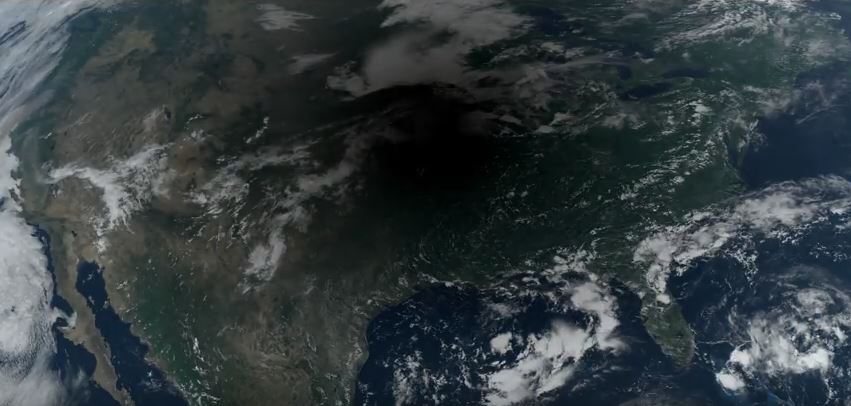
The 2017 Solar Eclipse as Seen by GOES-16: Scientists at the University of Wisconsin-Madison’s Space Science and Engineering Center (SSEC) and the Cooperative Institute for Meteorological Satellite Studies (CIMSS) observed the eclipse through the eye of one of the world’s most advanced weather satellites, GOES-16. The images were taken at a rate of one every five minutes. The resulting animation showed the shadow of the moon tracking west to east across the continental United States. The video, distributed through UW-Madison News and SSEC News, garnered more than 300,000 views on YouTube and Facebook: http://go.wisc.edu/184ew6 and http://go.wisc.edu/x1lx2c. The organizations also developed a website with eclipse information, local events, and other satellite viewing options that received more than 5000 visits in the days leading up to the eclipse: http://go.wisc.edu/8q2bkh. (K. Bah, CIMSS, 608-262-4462, J. Nelson, CIMSS, 608-263-6013, E. Verbeten, SSEC, 608-263-4206, T. Schmit, E/RA2, 08-263-0291, K. Winiecki, SSEC, 608-262-0987, J. Phillips, SSEC, 608-262-8164)
 (Click image to enlarge)
Figure caption: GOES-16 image of solar eclipse on 21 August 2017.
ITEMS FOR THE ADMINISTRATOR:
ITEMS FOR THE ASSISTANT ADMINISTRATOR:
ITEMS FOR THE OFFICE DIRECTOR, STAR:
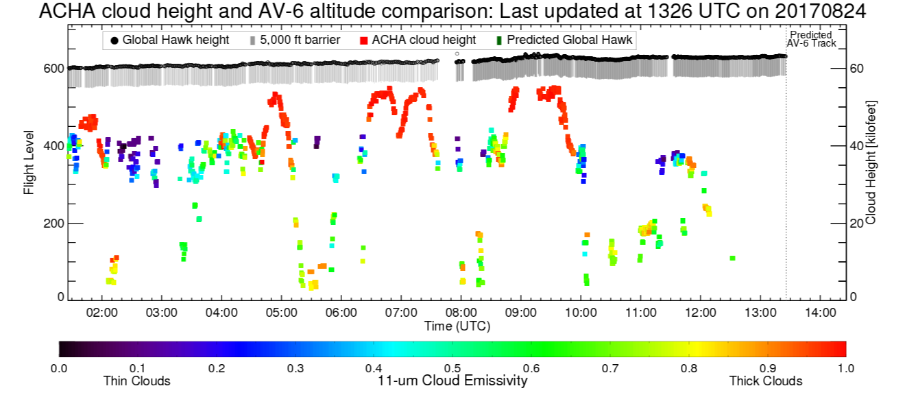
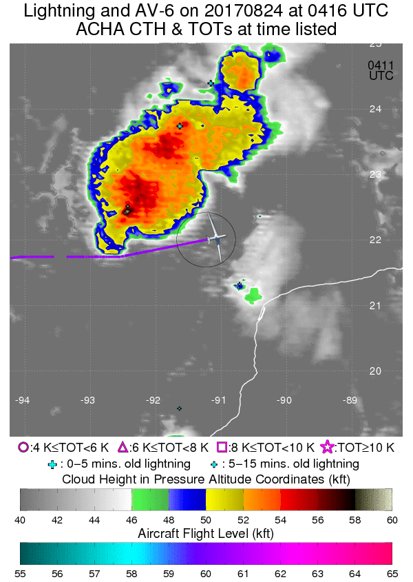
CIMSS Supports Global Hawk missions into Hurricane Harvey: The Cooperative Institute for Meteorological Satellite Studies (CIMSS) at the University of Wisconsin (UW) is once again providing tailored satellite product support for the NOAA Unmanned Aerial Vehicles project. The NASA Global Hawk is flying missions supported by NOAA into Hurricane Harvey in the Gulf of Mexico, collecting key data in advance of a potential landfall in Texas. CIMSS is providing critical mission flight guidance and hazard avoidance in the form of cloud-top height estimates, overshooting tops, wind shear and derived winds from the GOES satellites. These derived products are being produced from rapid scans being provided by NESDIS, including experimental/demonstrational 1-min data from GOES-16. Examples of the real-time product support are shown in the accompanying figures. (C. Velden, CIMSS, 608-262-9168; Sarah Griffin, CIMSS; A. Heidinger, E/RA2, 608-263-6757, S. Wanzong, CIMSS, 608-263-1950)
 (Click image to enlarge)
Figure caption: Graphic of Time-Height section of Global Hawk flight segment which is constantly updated in real time showing flight level and cloud tops. The 5000ft "curtain" below the plane is the avoidance zone for hazard safety.
 (Click image to enlarge)
Figure caption: Segment of Global Hawk flight pattern sampling TC Harvey on August 23rd. The plane is shown jogging around very high cloud-top heights (NESDIS ACHA product) as part of potential hazard (turbulence) avoidance.
World Meteorological Organization Meeting on Volcanic Clouds: Mike Pavolonis (NOAA/NESDIS/STAR) participated in a meeting of the World Meteorological Organization (WMO) Volcanic Ash Science Advisory Group (VASAG), August 21-23, 2017. The United States Geological Survey (USGS) Cascades Volcano Observatory (Vancouver, WA) hosted the WMO VASAG meeting. The WMO VASAG, which is composed of 10 experts on volcanic clouds, meets approximately once per year to respond to International Civil Aviation Organization (ICAO) requests for scientific guidance on matters related to volcanic clouds. ICAO is in the process of reviewing operational procedures for volcanic aviation hazards, with the goal of improving operational efficiency while ensuring safe operations. The WMO VASAG ensures that all proposed changes to operating procedures are scientifically sound, including the use of quantitative satellite products to better characterize volcanic cloud hazards. The work of the VASAG is very relevant to NOAA's mission, as NOAA operates two Volcanic Ash Advisory Centers. (M. Pavolonis, E/RA2, 608-263-9597, Mike.Pavolonis@noaa.gov)
ITEMS FOR THE DIVISION CHIEF, CoRP:
Critical Design Review for Advanced Dvorak Technique Project: A critical design review (CDR) for a major update to the Advanced Dvorak Technique (ADT) was held on August 23, 2017. The ADT is a computer-based technique, developed at the Cooperative Institute for Meteorological Satellite Studies (CIMSS), to objectively determine tropical cyclone (TC) intensity using operational geostationary satellite infrared imagery. The ADT operates globally, and can classify TC intensity from storm formation, through development and maturation, to dissipation. (C. Velden, CIMSS, 608-262-9168; T. Olander, CIMSS, 608-265-8005; J. Key, E/RA2, 608-263-2605, jkey@ssec.wisc.edu)
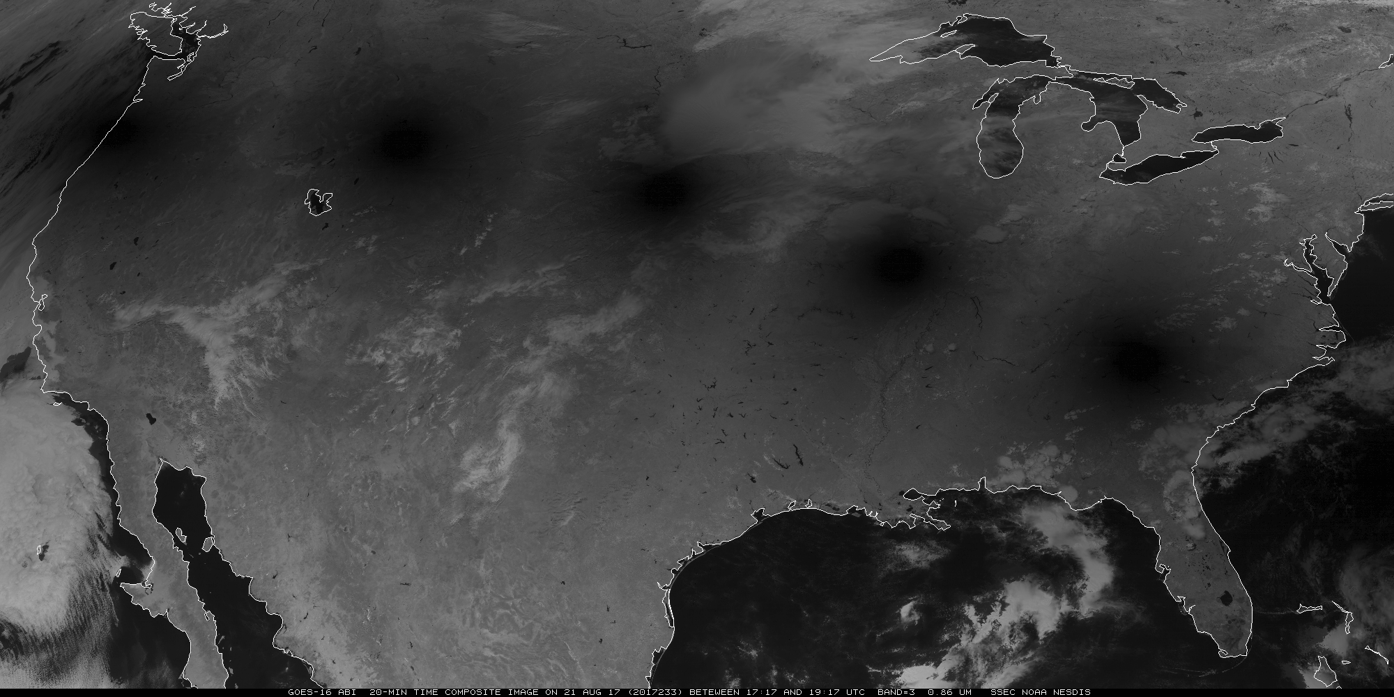
Satellites View the Great American Eclipse of 2017: Numerous satellites monitored the Great Eclipse of August 21, 2017. This included a research request for 1-minute mesoscale sectors from Geostationary Operational Environmental Satellite (GOES)-16, to supplement routine contiguous U.S. and full disk sectors. Cooling and the modification of the cumulus fields associated with the shadow were clearly seen. A number of polar-orbiting satellites also observed the shadow, such as Terra and Suomi National Polar-orbiting Partnership (NPP). The CIMSS Satellite Blog http://cimss.ssec.wisc.edu/goes/blog/archives/24751 showcases many of these images and animations. See also the "In the News" item above. (S. Bachmeier, CIMSS, 608-263-3958; T. Schmit, E/RA2, 608-263-0291, tim.j.schmit@noaa.gov)
 (Click image to enlarge)
Figure caption: Time composite (every 20 minutes) of the eclipse shadow from the GOES-16 Advanced Baseline Imager (ABI) 0.86 um near-infrared band.
VISITORS:
NEXT WEEK:
LOOKING AHEAD:
| Archived Weeklies Page | Submit a report item |