[ Archive ]
| CIMSS-NOAA Weekly Report [ Archive ] |
ASPB AND CIMSS WEEKLY HIGHLIGHTS FOR THE WEEK ENDING SEPTEMBER 1, 2017
IN THE PRESS:
SSEC and CIMSS Scientists In the News: Scientists from the University of Wisconsin-Madison Space Science and Engineering Center (SSEC) and the Cooperative Institute for Meteorological Satellite Studies provided their expertise and imagery related to Hurricane Harvey, flooding, and measuring thunderstorm potential: 1) NOAA ASPB scientist Tim Schmit talked with local NBC affiliate, WKOW 27, about Hurricane Harvey and how GOES-16 will help meteorologists track these storms in the future: http://go.wisc.edu/q7hpdj; 2) NASA Earth Observatory picked up a night-time Suomi NPP VIIRS image generated by William Straka III on 29 August 2017 showing Harvey's center of circulation had moved back into the Gulf of Mexico: http://go.wisc.edu/kw3294. Straka's images were also shared by @NOAASatellitePA: http://go.wisc.edu/62137m. 3) CIMSS scientist Shane Hubbard's flood projections related to Hurricane Harvey were picked up by the Washington Post on 29 August 2017: http://go.wisc.edu/1wul6u. He did an extended interview with the Washington Post on 31 August on the same topic: http://wapo.st/2x9O7j5. 4) Published this week: UW-Madison atmospheric and oceanic sciences graduate Jessica Gartzke and SSEC scientists developed a new method to predict thunderstorm potential over the Great Plains in near real-time by matching satellite measurements to radiosonde measurements to construct a picture of potential energy: http://go.wisc.edu/e2088v. (T. Schmit, E/RA2, 608-263-0291, W. Straka III, CIMSS, S. Hubbard, CIMSS,608-263-3712, J. Phillips, SSEC, 608-262-8164)
 (Click image to enlarge)
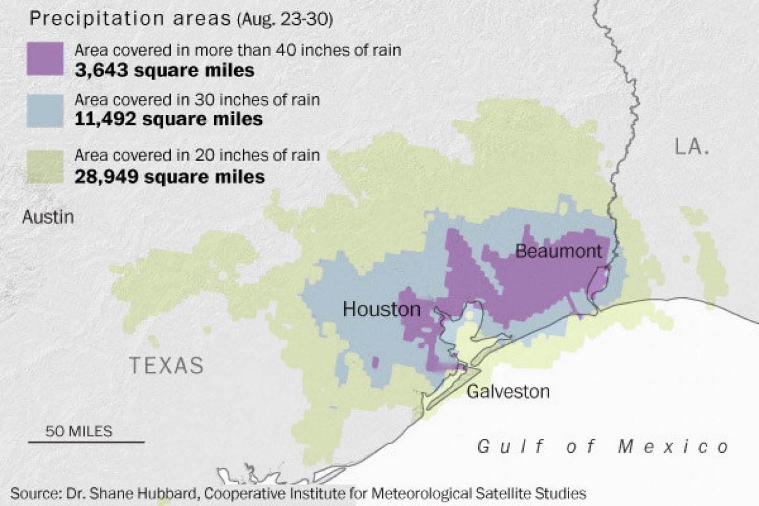
Figure caption: Precipitation areas, Aug. 23-30, 2017, resulting from Hurricane Harvey. Source: Shane Hubbard, CIMSS.
ITEMS FOR THE ADMINISTRATOR:
ITEMS FOR THE ASSISTANT ADMINISTRATOR:
ITEMS FOR THE OFFICE DIRECTOR, STAR:
GOES-S Teacher Workshop at Lockheed Martin: The Cooperative Institute for Meteorological Satellite Studies (CIMSS) organized a teacher workshop hosted by Lockheed Martin on August 23, 2017. Forty educators registered and thirty attended the exciting 1-day event. For those that made it, a unique experience ensued. A GOES-R ‘star-studded’ line-up kicked off the day with presentations by Laird Kantruss from Lockheed Martin (LM), GOES-R Program Director Mike Stringer and GOES-R Science Lead Steve Goodman. In addition, National Weather Service (NWS) meteorologist Paul Schlatter presented on GOES-16 contributions to the NWS Weather-Ready Nation initiative and Lockheed Martin Danielle Huaf shared LM Generation Beyond resources. And that was just the morning! After lunch educators were wowed by an up close view of the GOES-S Satellite in the clean room, along with finished but unassembled parts of GOES-T. The experience was awe-inspiring. As one teacher shared on the evaluation “It was amazing to see the actual spacecraft!” The full agenda is on-line at http://cimss.ssec.wisc.edu/education/goesr/GOES-S.html. Workshop evaluations collected at the end of the day resulted in seventeen participants giving the workshop an overall rating of “excellent”, ten chose “very good” and three chose “good”. Comments collected indicated that some teachers found the science content “over their heads” but everyone fully appreciated the experience. (M. Mooney, CIMSS, (608) 265-2123)
First GOES-R Series Virtual Course Seminar on the ABI: The first Geostationary Operational Environmental Satellite (GOES)-R Series Virtual Course Seminar was given on August 30, 2017. The topic was the Advanced Baseline Imager (ABI). This is part of the “inaugural Webinar Series for University Faculty: A free introduction for university faculty to the new capabilities offered by the latest-generation GOES-R series weather satellite. Seven live webinars by top experts in the field offered by the COMET® Program in partnership with NOAA NESDIS and the GOES-R Satellite Program Office”. More information about the recorded presentation on the ABI and upcoming seminars is available at http://courses.comet.ucar.edu/course/view.php?id=187. (T. Schmit, E/RA2, 608-263-0291, tim.j.schmit@noaa.gov)
CIMSS Blog Focuses on Hurricane Harvey: Researchers at the Cooperative Institute for Meteorological Satellite Studies (CIMSS) at the University of Wisconsin-Madison (UW-Madison) focused on the forecast and impacts of Hurricane Harvey this week in entries to the CIMSS Satelltie Blog. The entries included model data, geostationary and polar orbiting satellite data. The Geostationary Lightning Mapper (GLM) and Advanced Baseline Imager (ABI) on Geostationary Operational Environmental Satellite (GOES)-16 were featured prominently along with Suomin-NPP data, including the day-night band. Blog entries covered topics from general information about Hurricane Harvey, GLM lightning, increased turbidity in the region after the storm passed, power outages, and spectacular imagery from landfall. http://cimss.ssec.wisc.edu/goes/blog/?s=Harvey. (M. Gunshor, CIMSS, 608-263-1146, S. Lindstrom, CIMSS, S. Bachmeier, CIMSS) 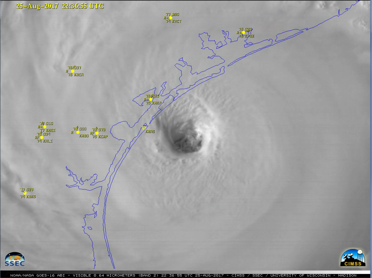 (Click image to enlarge)
Figure caption: Hurricane Harvey making landfall as seen by GOES-16 ABI visible band 2 (0.64um).
ITEMS FOR THE DIVISION CHIEF, CoRP:
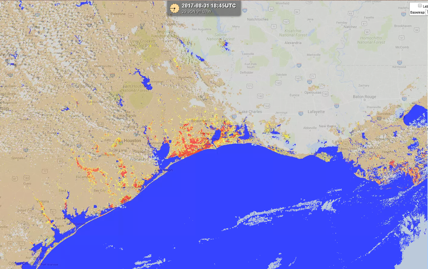
VIIRS Flood Product Over Houston: A flood detection product, developed by Sanmei Li and Donglian Sun at George Mason University (GMU), is generated routinely at the Cooperative Institute for Meteorological Satellite Studies (CIMSS) using Visible Infrared Imaging Radiometer Suite (VIIRS) direct broadcast data. This week, the product has captured flooding caused by Hurricane Harvey along the Gulf Coast in Texas and Louisiana. CIMSS distributes this product to the Federal Emergency Management Agency (FEMA), National Weather Service River Forecast Center offices, and it is publically available online via RealEarth (http://realearth.ssec.wisc.edu). (J. Hoffman, CIMSS, 608-780-1690, D. Santek, CIMSS, 608-263-7410)
 (Click image to enlarge)
Figure caption: VIIRS Flood Product displayed in RealEarth showing recent flooding in South Texas and Louisiana.
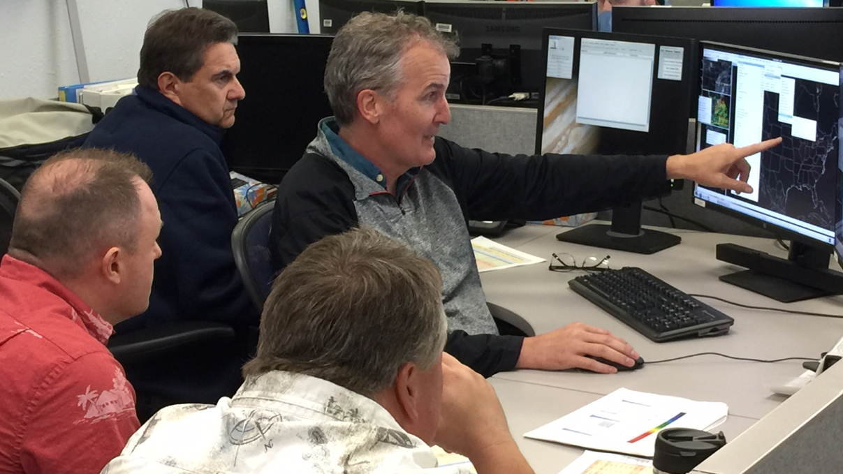
Visits to NWS MKE for GOES-16 Familiarization: The Geostationary Operational Environmental Satellite (GOES)-16 on-site familiarization of the NWS Forecast Office Milwaukee/Sullivan, WI was completed on August 31, 2017. The training was lead by folks from CIMSS and/or ASPB over six separate trips. The entire office staff reviewed the uses of the GOES-16 Advanced Baseline Imager (ABI) spectral bands, band differences, Red-Green-Blue (RGB) band combination and derived products. (J. Gerth, CIMSS; S. Lindstrom, CIMSS; T. Schmit, E/RA2, 608-263-0291, tim.j.schmit@noaa.gov)
 (Click image to enlarge)
Figure caption: S. Lindstrom, CIMSS, working with members of the Milwaukee/Sullivan Forecast Office.
VIIRS High-Resolution Forecast of Canadian Wildfire Smoke: High resolution 24 hour smoke trajectory forecasts (http://smoke.ssec.wisc.edu/idea-i-aerosolHR-live-test/index.php)initialized with Joint Polar Satellite System (JPSS) Visible Infrared Imaging Radiometer Suite (VIIRS) Aerosol Optical Depth retrievals on August 30, 2017 show transport of smoke from Canadian wildfires transported from over Lake Superior to southeastern Wisconsin on August 31, 2017. The wildfire smoke impacted surface fine particulate matter concentrations (<2.5 microns, PM2.5) at the Chiwaukee, WI monitor located on the Wisconsin-Illinois border along the western shore of Lake Michigan. Particulate concentrations reached levels >40 micrograms per cubic meter which are deemed unhealthy for sensitive groups. These real-time smoke forecasts are being developed as part of the JPSS Fire and Smoke Initiative and supports NWS and regional air quality forecasting (R.B. Pierce, E/RA2, 608-890-1892, brad.pierce@noaa.gov,J. Davies, SSEC, K. Strabala, CIMSS)
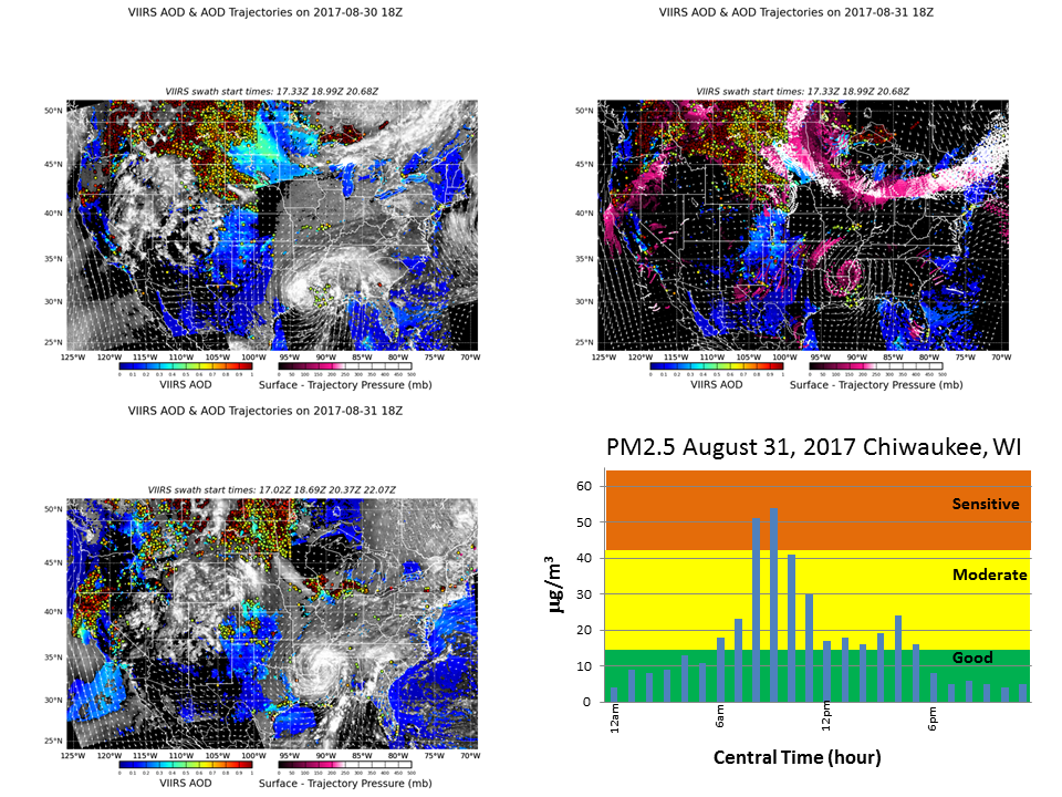 (Click image to enlarge)
Figure caption: The left panels show VIIRS Aerosol Optical Depth (AOD, and Cloud Optical Thickness (COT) and initial trajectory locations on August 30 (upper left) and 31 (lower left), 2017. The right panels show the 24 hour forecast smoke trajectories initialized on August 30, 2017 (upper right) and surface PM2.4 concentrations at the Chiwaukee, WI air quality monitor on August 31, 2017 (lower right)
VISITORS:
NEXT WEEK:
LOOKING AHEAD:
| Archived Weeklies Page | Submit a report item |