[ Archive ]
| CIMSS-NOAA Weekly Report [ Archive ] |
ASPB AND CIMSS WEEKLY HIGHLIGHTS FOR THE WEEK ENDING SEPTEMBER 8, 2017
IN THE PRESS:
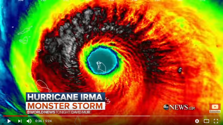
SSEC and CIMSS Scientists In the News: Scientists at the University of Wisconsin-Madison Space Science and Engineering Center (SSEC) and the Cooperative Institute for Meteorological Satellite Studies (CIMSS) provided expert commentary, interviews, and imagery to the media on topics ranging from flooding, Hurricane Harvey, and Hurricane Irma:
(J. Phillips, SSEC, 608-262-8164; S. Hubbard, CIMSS, 608-263-3712; C. Velden, CIMSS, 608-262-9168; D. Herndon, CIMSS, 608-262-6741; W. Straka, III, CIMSS)
 (Click image to enlarge)
Figure caption: Suomi NPP VIIRS image of Hurricane Irma. Credit: W. Straka III, CIMSS.
ITEMS FOR THE ADMINISTRATOR:
ITEMS FOR THE ASSISTANT ADMINISTRATOR:
ITEMS FOR THE OFFICE DIRECTOR, STAR:
Paper Published Comparing Shortwave Absorption Trends in the Polar Oceans: A paper titled "Increasing shortwave absorption over the Arctic Ocean is not balanced by trends in the Antarctic", by C. Katlein, C., S. Hendricks, and J. Key was published in the journal The Cryosphere (2017, 11, 2111-2116, https://doi.org/10.5194/tc-11-2111-2017). Using the NOAA AVHRR Polar Pathfinder - Extended (APP-x) dataset, which was developed by NOAA and Cooperative Institute for Meteorological Satellite Studies (CIMSS) scientists, it was shown that despite the observed increase of sea ice extent in the Antarctic, absorption of solar shortwave radiation in the Southern Ocean poleward of 60° latitude is not decreasing. The observations show that the small increase in Antarctic sea ice extent does not compensate for the combined effect of retreating Arctic sea ice and changes in cloud cover, which both result in a total increase in solar shortwave energy deposited into the polar oceans. (J. Key, E/RA2, 608-263-2605, jkey@ssec.wisc.edu)
Satellite Support for Hurricane Intensity Estimation: The intensities of three hurricanes are being monitored this week (Irma, Jose and Katia) with the help of GOES and polar satellite algorithms developed at the Cooperative Institutes in Madison and Ft. Collins. A consensus of these satellite intensity estimates (SATCON) is providing good agreements with aircraft measurements in Irma (see figure). The SATCON plots are being produced in real time and are being viewed by forecasters at the National Hurricane Center as part of a JPSS Proving Ground demonstration. (C. Velden, CIMSS, 608-262-9168; D. Herndon, CIMSS; T. Olander, CIMSS; G. Chirokova, CIRA; J. Knaff, RAMMB/CIRA).
 (Click image to enlarge)
Figure caption: Plot of SATCON intensity estimates for Hurricane Irma.
VIIRS Sea Ice Concentration has Positive Impact on Ice Edge Prediction: The Naval Oceanographic Office (NAVOCEAN or NAVO) recently reported that the assimilation of the Visible Infrared Imaging Radiometer Suite (VIIRS) sea ice concentration product in the Arctic Cap Nowcast/Forecast System (ACNFS) reduces ice edge error (position) by 25%. Furthermore, VIIRS ice concentration results in better ice edge information than using passive microwave-derived ice concentration alone due to its higher spatial resolution, which is particularly important along the edge of the pack ice. The VIIRS ice concentration product was developed by Cooperative Institute for Meteorological Satellite Studies (CIMSS) and NOAA scientists. (J. Key, E/RA2, 608-263-2605, jkey@ssec.wisc.edu)
ITEMS FOR THE DIVISION CHIEF, CoRP:
Jun Li Visits NASA JPL: Invited by JPL OSSE (Observing System Simulation Experiment), Cooperative Institute for Meteorological Satellite Studies (CIMSS) scientist Jun Li visited the NASA Jet Propulsion Lab (JPL) on 05 September 2017. He gave a seminar titled "Impact from CubeSat and GEO based sounding systems on high impact weather forecasts - an end-to-end OSSE study" (available upon request). He also discussed with the AIRS science team and OSSE team various topics including the linkage between observations and Earth science questions, applications of current and future NASA earth system observations for weather applications, radiative transfer simulation of observations, and better combination of observations and numerical models. (Jun Li, CIMSS, Jun.Li@ssec.wisc.edu, 608-698-9768)
ABI Presentation at the GOES-R Series Summit: T. Schmit gave a presentation on the Advanced Baseline Imager (ABI) at the Geostationary Operational Environmental Satellite (GOES)-R Series Summit in College Park, Maryland. This presentation showcased the improved attributes of the ABI and included imagery from the Great American Eclipse and Hurricane Harvey. The summit also included a number of user testimonials on how the ABI has been used in operations, both at the Weather Prediction Center and the Ocean Prediction Center. (T. Schmit, E/RA2, 608-263-0291, tim.j.schmit@noaa.gov)
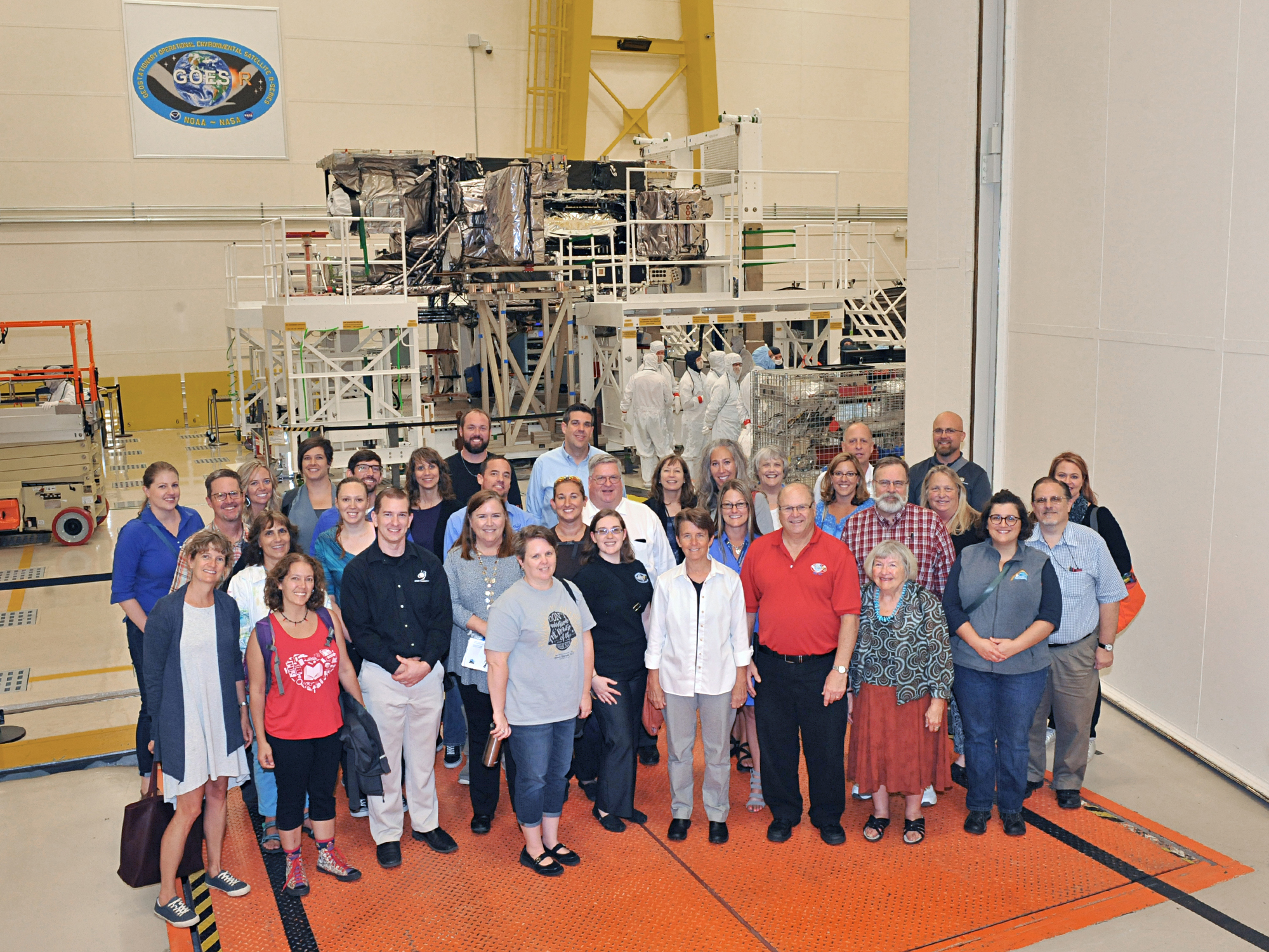
GOES-S Teacher Workshop Group Photo : Lockheed Martin released this group photo from the August 23 GOES-S Teacher Workshop showing participants and presenters in front of the fully integrated GOES-S Satellite. More information about the 1-day event can be can be found at http://cimss.ssec.wisc.edu/education/goesr/. (M. Mooney, CIMSS, (608) 213 5399)
 (Click image to enlarge)
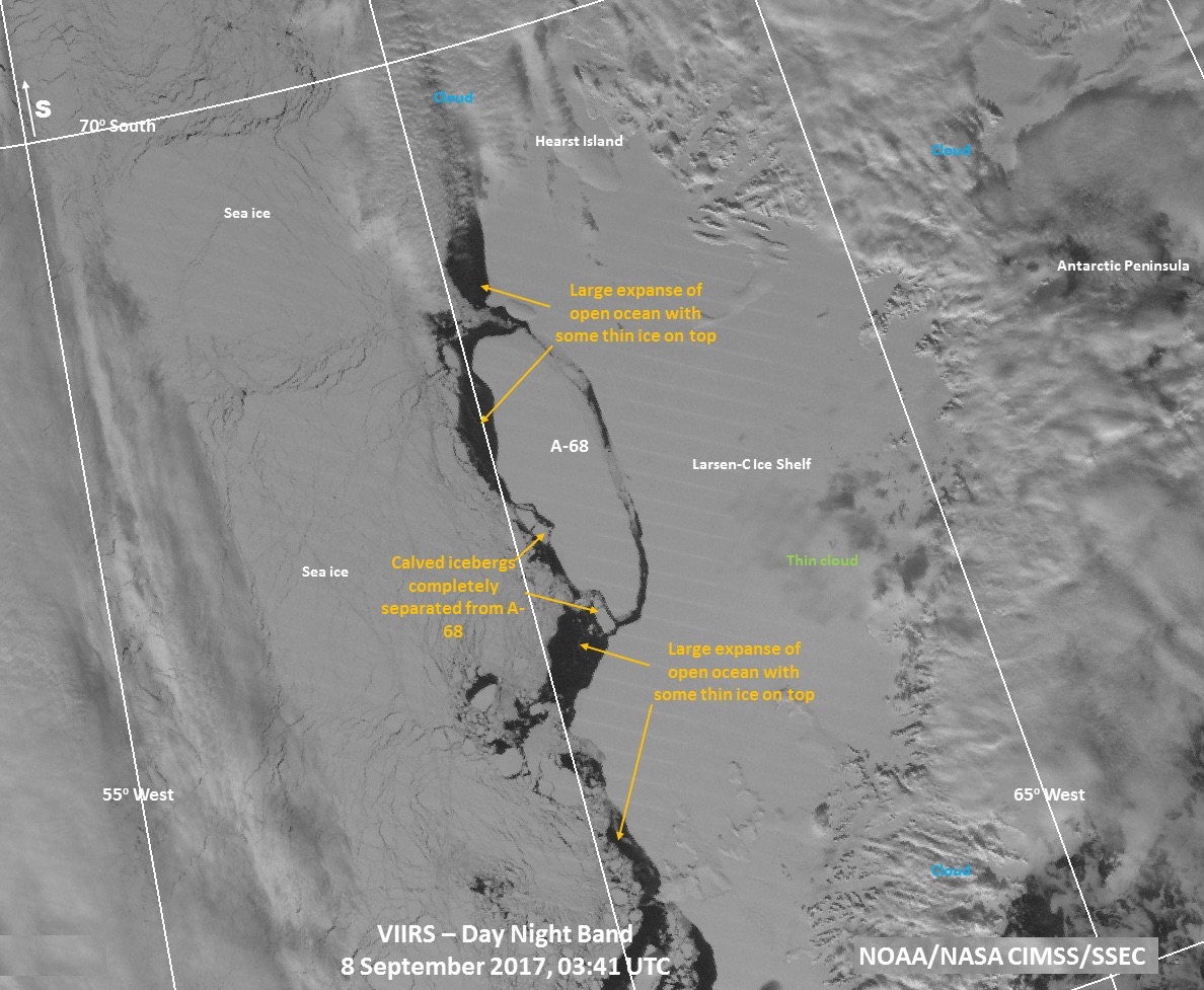
VIIRS Monitors Massive Iceberg in Antarctica: In mid-July, Antarctica shed a very large piece of the Larsen C ice shelf, located on the Antarctic Peninsula. A block of ice the size of Delaware broke off and is now an iceberg named A-68. This calving event has created one of the largest icebergs on record, though its size is not unprecedented in recent decades. William Straka III (Cooperative Institute for Meteorological Satellite Studies, CIMSS) and Jeff Key (STAR) have been monitoring A-68 since it separated from the ice shelf. A VIIRS day-night band (DNB) image on 8 September 2017 is shown below. Additional images and information are available on the Global Cryosphere Watch (GCW) website at http://globalcryospherewatch.org/interesting/archive/larsenc2017/. (W. Straka III, CIMSS; J. Key, E/RA2, 608-263-2605, jkey@ssec.wisc.edu)
 (Click image to enlarge)
Figure caption: The position and condition of iceberg A-68 on 8 September 2017 at 04:18 UTC, as viewed by the VIIRS day-night band (DNB).
VISITORS:
NEXT WEEK:
LOOKING AHEAD:
| Archived Weeklies Page | Submit a report item |