[ Archive ]
| CIMSS-NOAA Weekly Report [ Archive ] |
ASPB AND CIMSS WEEKLY HIGHLIGHTS FOR THE WEEK ENDING SEPTEMBER 15, 2017
IN THE PRESS:
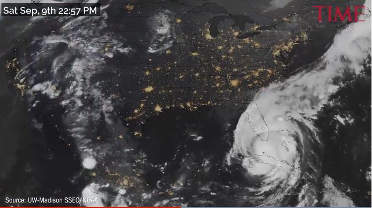
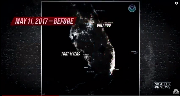
SSEC and CIMSS Scientists In the News: Scientists at the University of Wisconsin-Madison Space Science and Engineering Center (SSEC) and the Cooperative Institute for Meteorological Satellite Studies (CIMSS) continued to provided expert commentary, interviews, and imagery to the media on topics ranging from flooding, disaster planning, and advances in hurricane forecasting, and Hurricanes Harvey Irma. In addition to the stories highlighted below, see SSEC In the News for more media mentions: http://go.wisc.edu/56jzc3. SSEC scientists Kaba Bah and Rick Kohrs created an animation of Hurricanes Irma and José using data from GOES-16 and Suomi-NPP. It was picked up by TIME: http://go.wisc.edu/chuaff. Chris Velden, Derrick Herndon, and Sarah Griffin, CIMSS Tropical Cyclones Group, were interviewed this week by the Milwaukee Journal Sentinel, NPR, the Tampa Bay Times, WORT Radio, the Badger Herald, and WISC about advances in hurricane forecasting, storm tracks, and intensities: NPR: http://go.wisc.edu/6sv5rv; Milwaukee Journal Sentinel: http://go.wisc.edu/gxv2q4; WISC: http://go.wisc.edu/osvk8d. CIMSS scientist Shane Hubbard provided analyses and information on decision-making in response to natural disasters. This week, he was interviewed by the Houston Chronicle. Suomi NPP VIIRS images of Hurricane Harvey and Hurricane Irma processed by CIMSS researcher William Straka III were picked up by several outlets adn used by the JPSS Program Office: NBC Nightly News, ABC World News Tonight, http://go.wisc.edu/k3k2kq, http://go.wisc.edu/7rej0i; Vox: http://go.wisc.edu/770i5g. In addition, both pre- and post-Irma DNB Imagery was distributed to relevant agencies and utility companies in Florida as part of evaluating the usefulness for post-storm recovery of the power grid for future storms. (K. Bah, CIMSS, 608-262-4482; R. Kohrs, SSEC, 608-263-6312; C. Velden, CIMSS, 608-262-9168; D. Herndon, CIMSS, 608-262-6741; S. Hubbard, CIMSS, 608-263-3712;W. Straka, III; CIMSS, J. Phillips, SSEC, 608-262-8164)
 (Click image to enlarge)
Figure caption: Snapshot of a GOES-16 and Suomi-NPP animation of Hurricanes Irma and Jose. The animation is available at http://go.wisc.edu/chuaff. Credit: K. Bah, R. Kohrs, SSEC.
 (Click image to enlarge)
Figure caption: Suomi NPP VIIRS DNB image of power outages from Hurricane Irma used on NBC Nightly News. Credit: W. Straka III, CIMSS.
ITEMS FOR THE ADMINISTRATOR:
ITEMS FOR THE ASSISTANT ADMINISTRATOR:
ITEMS FOR THE OFFICE DIRECTOR, STAR:
Committee on Earth Observation Satellites Workshop: Mike Pavolonis (NOAA/NESDIS/STAR) participated in the 2017 Committee on Earth Observation Satellites (CEOS) Strategic Implementation Team (SIT) Technical Workshop September 13-14, 2017, in Frascati, Italy. M. Pavolonis attended the SIT workshop in support of NOAA’s contributions to the CEOS Working Group on Disasters. NOAA contributes significantly to data coordination, flood, and volcano initiatives within the Working Group on Disasters. Next month, the Assistant Administrator of NOAA/NESDIS will begin a two-year term as the CEOS SIT Chair. Work within STAR to develop multi-sensor products for operational volcanic hazard monitoring is well aligned with the priorities on the incoming SIT Chair. It is anticipated that STAR will continue to support volcanic hazard data fusion initiatives within the CEOS Working Group on Disasters. NOAA has an operational mandate to issue volcanic ash cloud advisories. Thus, participation in CEOS initiatives related to improving volcanic hazard detection and characterization benefits NOAA and it’s stakeholders. (M. Pavolonis, E/RA2, 608-263-9597, Mike.Pavolonis@noaa.gov)
Manuscript on Imager and Sounder Fusion Published: A paper titled “Fusion of satellite-based imager and sounder data to construct supplementary high spatial resolution narrowband IR radiances”, by E. Weisz, B. A. Baum and W. P. Menzel, has been published in the Journal of Applied Remote Sensing (Volume 11, Issue 3). Unlike the Moderate-Resolution Imaging Spectroradiometer (MODIS), the Visible Infrared Imaging Radiometer Suite (VIIRS) does not have any spectral bands sensitive to carbon dioxide and water vapor. The imager-sounder fusion technique uses VIIRS and CrIS (Cross-track Infrared Sounder) data to construct the missing bands at high spatial resolution (750 m). The article can be viewed online at http://dx.doi.org/10.1117/1.JRS.11.036022. (Elisabeth Weisz, CIMSS, 608-265-3954)
ITEMS FOR THE DIVISION CHIEF, CoRP:
Global Cryosphere Watch - Arctic PRCC Meeting: Jeff Key participate remotely in a meeting to discuss interactions between the World Meteorological Organization (WMO) Global Cryosphere Watch (GCW) program and the newly-formed WMO Polar Regional Climate Center for the Arctic. The meeting was held 13 September 2017 at Environment and Climate Change Canada (ECCC) in Montreal. Key also participated remotely in the GCW Portal Team meeting that followed the GCW-PRCC meeting on 14-15 September. (J. Key, E/RA2, 608-263-2605, jkey@ssec.wisc.edu)
CIMSS at the Satellite Training Advisory Team L2 Planning Meeting in Huntsville: Scott Lindstrom, Cooperative Institute for Meteorological Satellite Studies (CIMSS), attended the Satellite Training Advisory Team (STAT) Planning Meeting for Level 2 Products produced from GOES-16. The meeting occurred in Huntsville, AL, 12-14 September 2017 and overlapped with the Geostationary Lightning Mapper (GLM) 2017 Science Team Meeting. The outcome of the meeting was a list of training products that CIMSS is tasked with developing. (S. Lindstrom, CIMSS, 608-263-4425)
CIMSS Participation in GOES-16 Training at Environment Canada: Scott Lindstrom, Cooperative Institute for Meteorological Satellite Studies (CIMSS), was asked to present at a Training Telecon with Environment Canada on 11 September 2017. He described Forecast Applications for all 16 GOES-16 ABI Bands. This was part of a Train-the-Trainer exercise that continues in late October and is part of the spin-up to Environment Canada’s system-wide training of forecasters on the uses of GOES-16. (S. Lindstrom, CIMSS, 608 263 4425)
Visit to Italian Geophysical Institute: M. Pavolonis visited the Istituto Nazionale di Geofisica e Vulcanologia (INGV) in Rome, Italy on September 11 and September 15, 2017. A seminar was given on the NOAA/NESDIS mission and volcanic cloud remote sensing activities in NOAA/NESDIS/STAR. The objectives of the visit were to initiate collaboration on satellite remote sensing and begin planning a World Meteorological Organization (WMO) sponsored volcanic ash satellite product inter-comparison exercise. The development and validation of multi–sensor applications for operational volcanic hazard monitoring was identified as a topic of mutual interest and benefit to NOAA and INGV. Work on comparing and validating satellite derived ash cloud height products from NOAA and INGV was commenced during the visit. In addition, INGV is a major contributor to the WMO inter-comparison exercise, which is lead by NOAA/NESDIS/STAR. INGV may host the WMO inter-comparison workshop in 2018. It is anticipated that collaboration between NOAA and INGV will accelerate the development of advanced multi-sensor products for operational volcanic hazard monitoring. (M. Pavolonis, E/RA2, 608-263-9597, Mike.Pavolonis@noaa.gov)
CIMSS Satellite Blog Focuses on Hurricane Irma: Researchers blogging at the Cooperative Institute for Meteorological Satellite Studies (CIMSS) at the University of Wisconsin-Madison (UW-Madison) focused on the Florida landfall and aftermath of Hurricane Irma this week in entries to the CIMSS Satellite Blog (http://cimss.ssec.wisc.edu/goes/blog/?s=Irma). The entries include satellite data from GOES-16 and Suomi-NPP and chronicle the hurricane's path through the Caribbean, past Cuba, and finally into Florida. The final entry includes before and after Suomi-NPP true color imagery showing the before and after images displaying the changes, especially evident in the coastal waters of Florida. The blog entries highlight for the public the utility of both geostationary and polar orbiting satellite data and services provided by NOAA during a disaster. (S. Bachmeier, CIMSS, 608-263-3958, S. Lindstrom, CIMSS)
VISITORS:
NEXT WEEK:
LOOKING AHEAD:
| Archived Weeklies Page | Submit a report item |