[ Archive ]
| CIMSS-NOAA Weekly Report [ Archive ] |
ASPB AND CIMSS WEEKLY HIGHLIGHTS FOR THE WEEK ENDING SEPTEMBER 22, 2017
IN THE PRESS:
ITEMS FOR THE ADMINISTRATOR:
ITEMS FOR THE ASSISTANT ADMINISTRATOR:
ITEMS FOR THE OFFICE DIRECTOR, STAR:
Visit to EUMETSAT Cloud Team: Andy Heidinger conducted a GOES-R Visiting Scientist trip to the European Organisation for the Exploitation of Meteorological Satellites (EUMETSAT) in Darmstadt, Germany. He was hosted by Dr. Philip Watts who leads the cloud product development efforts at EUMETSAT for their geostationary and polar orbiting imagers. During the visit, discussions were held on multiple topics of mutual interest including (1) understanding the treatment of multilayer clouds in optimal estimation approaches, (2) the application of EUMETSAT cloud algorithms to GOES-16 and (3) the planning of the next meeting of the International Cloud Working Group (ICWG). During this visit, Heidinger gave a seminar and attended the Science Advisory Group Meeting for the METimage sensor, which is the meteorological imager on the EUMETSAT Polar System –Second Generation (EPS-SG). EUMETSAT expressed interest in formalizing and extending the relationship between the NOAA and EUMETSAT cloud teams. (A. Heidinger, E/RA2, 608-263-6757, andrew.heidinger@noaa.gov)
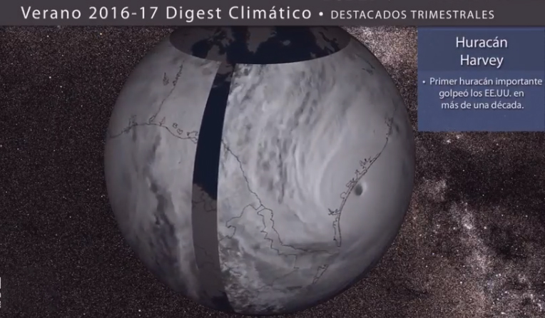
Dual Language SOS Product includes Hurricane Harvey GOES-16 Data: The Cooperative Institute for Meteorological Satellite Studies (CIMSS) published the summer 2017 Climate Digest this week featuring global weather and climate phenomena for June, July and August. The quarterly climate digest, produced seasonally, consists of a short movie distributed to the NOAA Science On a Sphere (SOS) Network of over 100 science centers. The video is also accessible on YouTube. Of note, rapid-scan GOES-16 imagery of Hurricane Harvey making landfall and Houston metro precipitation graphics developed at CIMSS are included in the SOS product, and for the first time, a Spanish language version was also released. Both versions conclude with a reference to NOAA’s National Weather Service Weather-Ready Nation initiative. More information can be found at http://sphere.ssec.wisc.edu/summer2017/. (M. Mooney, CIMSS, 608-265-2123, R. Kohrs, SSEC, (608) 263 6312, C. Suplinski, SSEC, 608-262-0502)
 (Click image to enlarge)
World Meteorological Organization Panel on Nowcasting: Mike Pavolonis (NOAA/NESDIS/STAR) participated in a meeting of the World Meteorological Organization (WMO) Sustained Coordinated Processing of Environmental Satellite Records for Nowcasting (SCOPE-Nowcasting) Executive Panel, September 18-20, 2017 in Geneva, Switzerland. Pavolonis is the NOAA representative on the SCOPE-Nowcasting Executive Panel, and was nominated to chair the panel. The overarching goal of SCOPE-Nowcasting is to demonstrate continuous and sustained provision of consistent, well-characterized satellite products for nowcasting (forecasts that range from minutes to 6 hours) and severe weather reduction. Meteorological satellite data, particularly from next generation satellites, contain a wealth of information for nowcasting applications such as severe weather, volcanic hazards, dust storms, and various aviation hazards. Rapid extraction of critical information from very large volumes of satellite data remains a challenge. The Executive Panel met to develop pilot projects aimed at increasing the value of satellite measurements for nowcasting, establishing/refining standards for nowcasting products, and improving access to near real-time nowcasting products. Previous SCOPE-Nowcasting pilot projects have led to improvements in product quality, access, and standards. Detailed information on the new pilot projects being developed will be made available at http://www.wmo.int/pages/prog/sat/meetings/SCOPE-Nowcasting-EP-1.php. (M. Pavolonis, E/RA2, 608-263-9597, Mike.Pavolonis@noaa.gov)
ITEMS FOR THE DIVISION CHIEF, CoRP:
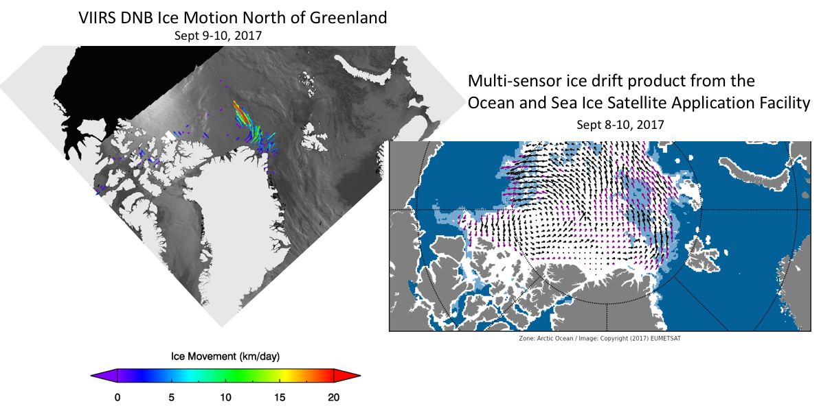
Ice Motion Tracked in VIIRS Day-Night Band: A new research product that uses Visible Infrared Imaging Radiometer Suite (VIIRS) Day-Night Band (DNB) Near Constant Contrast (NCC) imagery to create daily sea ice motion vectors is in the final stages of development. This product will expand upon the suite of daily ice motion products that use Advanced Microwave Scanning Radiometer 2 (AMSR2) and VIIRS infrared imagery. The VIIRS NCC product compares imagery from two orbits twenty-four hours apart using a statistical method that translates spatial displacements of sea ice features into motion. The DNB NCC imagery will provide a year-round resource for determining ice motion in the Arctic and Antarctic at ~1km resolution. Current ice motion products using passive microwave data are not reliable during the summer due to highly variable sea ice emissivity, and are much lower spatial resolution. (A. Letterly, CIMSS, 608-890-1981; J. Key, E/RA2, 608-263-2605, jkey@ssec.wisc.edu)
 (Click image to enlarge)
Figure caption: DNB NCC ice motion vectors (left) off the coast of NE Greenland compare favorably to the vectors from multi-sensor drift product from OSI-SAF (right). These data are from September 9-10, 2017.
CIMSS Presence at 9th European Conference on Severe Storms: Leigh Orf and Ralph Petersen, both from the Cooperative Institute for Meteorological Satellite Studies (CIMSS), made presentations at the 9th European Conference on Severe Storms in Pula, Croatia from 18 – 22 September 2017. The papers were: Leigh Orf, "Simulations of devastating tornadoes embedded within supercell thunderstorms"; Ralph Petersen, Brett Hoover, Anne-Sophie Daloz, Lee Cronce, Tim Wagner, Skylar Williams, Richard Mamrosh, Randy Baker, Patricia Pauley, and Nancy Baker, "Aircraft Moisture Observations: Their importance in Nowcasting and NWP"; and Ralph Petersen, Lee Cronce, John Mecikalski, and Chris Jewett, "Improving Convective Weather Nowcasts by Coupling Convective Initiation Products to GOES-R Legacy Sounding NearCasts of the Storm Environment." (L. Orf, CIMSS, 608-890-1983, R. Petersen, CIMSS, 608-263-4030)
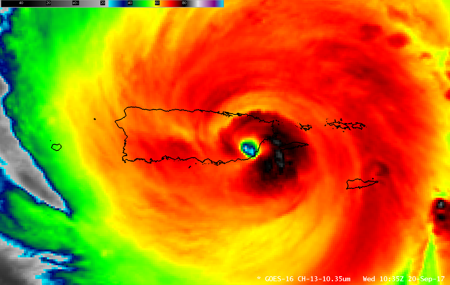
Hurricane Maria on the CIMSS Satellite Blog: The CIMSS Satellite Blog had daily updates on the progress of Maria across the Atlantic and northern Caribbean: formation as a Tropical Storm; Rapid Intensification; striking Dominica; landfall in Puerto Rico; Day Night Band imagery that showed post-Maria power on Puerto Rico; reorganization north of Hispaniola. (https://cimss.ssec.wisc.edu/goes/blog/?s=Maria) (S. Lindstrom, CIMSS ; 608 263 4425 ; S. Bachmeier, CIMSS, 608-263-3958 )
 (Click image to enlarge)
Figure caption: Maria makes landfall in Puerto Rico, GOES-16 ABI "Clean Window" Infrared Image (10.3 µm), 1035 UTC on 20 September 2017
VISITORS:
NEXT WEEK:
LOOKING AHEAD:
| Archived Weeklies Page | Submit a report item |