[ Archive ]
| CIMSS-NOAA Weekly Report [ Archive ] |
ASPB AND CIMSS WEEKLY HIGHLIGHTS FOR THE WEEK ENDING JANUARY 5, 2018
IN THE PRESS:
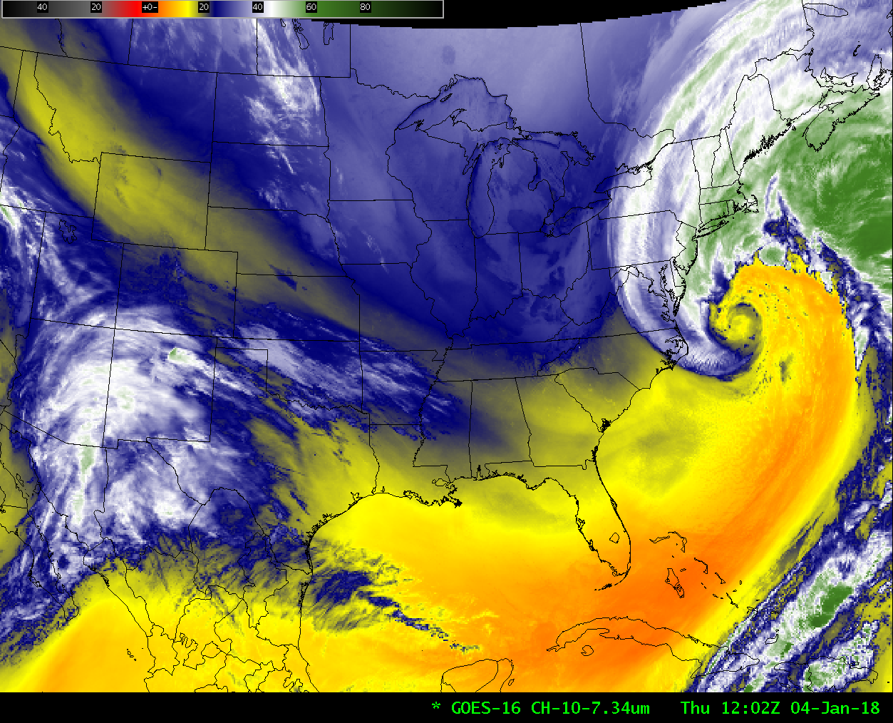
SSEC and CIMSS Scientists in the News: Scientists at the University of Wisconsin-Madison Space Science and Engineering Center (SSEC) and the Cooperative Institute for Meteorological Satellite Studies (CIMSS) provide expert commentary, interviews, and imagery to news media. In the news this week: 1) SSEC researcher Jordan Gerth’s op-ed on JPSS-1, and the importance of sustained funding for satellite technology and applied scientific research, was published by The Hill: "Weather satellite and scientists may face funding drought despite devastating hurricanes", http://go.wisc.edu/2jb69p. He was also the featured expert on the UW-Madison News page: https://experts.news.wisc.edu/. 2) CIMSS scientists Scott Bachmeier and Scott Lindstrom posted imagery and analyses of the January 3-4 East coast winter storm on the CIMSS Satellite Blog (http://cimss.ssec.wisc.edu/goes/blog/), which were picked up by Discover magazine: "The view from space as the so-called ‘bomb cyclone’ exploded into a dangerous winter storm", http://go.wisc.edu/gk2w38. (J. Phillips, SSEC, 608-262-8164)
 (Click image to enlarge)
Figure caption: GOES-16 low-level water vapor (7.3 µm) infrared imagery, 0102-1332 UTC on 4 January 2018. Credit: CIMSS.
ITEMS FOR THE ADMINISTRATOR:
ITEMS FOR THE ASSISTANT ADMINISTRATOR:
ITEMS FOR THE OFFICE DIRECTOR, STAR:
Manuscript on the assimilation of CrIS cloud-cleared radiances published: A manuscript entitled "The Impact of Cross-track Infrared Sounder (CrIS) Cloud-Cleared Radiances on Hurricane Joaquin (2015)and Matthew (2016) Forecasts" has been published in the Journal of Geophysical Research - Atmospheres, 122, DOI: 10.1002/2017JD027515. In this study, a novel approach is proposed to make use of ample partially cloudy scenes to take advantage of the thermodynamic information from cloudy skies through the assimilation of cloud-cleared CrIS radiances. By assimilating more information from cloudy regions, significant improvement in the NWP forecasting for Hurricane Joaquin (2015) and Hurricane Matthew (2016) is achieved. Comparing temperature, specific humidity, and U/V winds with radiosondes indicates that the data impacts are growing larger with longer time forecasts (beyond 72-hour forecast). The improvement on reducing the track forecast error is also achieved with the assimilation of cloud-cleared radiances. Co-authors are Wang Pei, Jun Li, Zhenglong Li, Agnes H. N. Lim, Jinlong Li (CIMSS), Timothy J. Schmit (STAR), and Mitchell D. Goldberg (JPSS). (Jun Li, CIMSS, 608-262-3755, Jun.Li@ssec.wisc.edu)
GOES-R Article Published in APWA Reporter: The article "GOES-R: What's new in orbit" was published in the January issue of the American Public Works Association (APWA) Reporter. Cooperative Institute for Meteorological Satellite Studies (CIMSS) researcher Mat Gunshor was asked by APWA to contribute to the APWA Reporter as part of an effort to bring American Meteorological Society (AMS) members and APWA members together on issues of common interest. The article was written to bring awareness to public works employees who may benefit from learning about the nation's newest geostationary satellite and it appears in the magazine between articles on National Weather Service (NWS) radar and the Weather Ready Nation strategic initiative, both authored by NWS employees. The magazine can be viewed freely online here: https://issuu.com/apwa/docs/201801_reporteronline. (M. Gunshor, CIMSS, 608-263-1146)
 (Click image to enlarge)
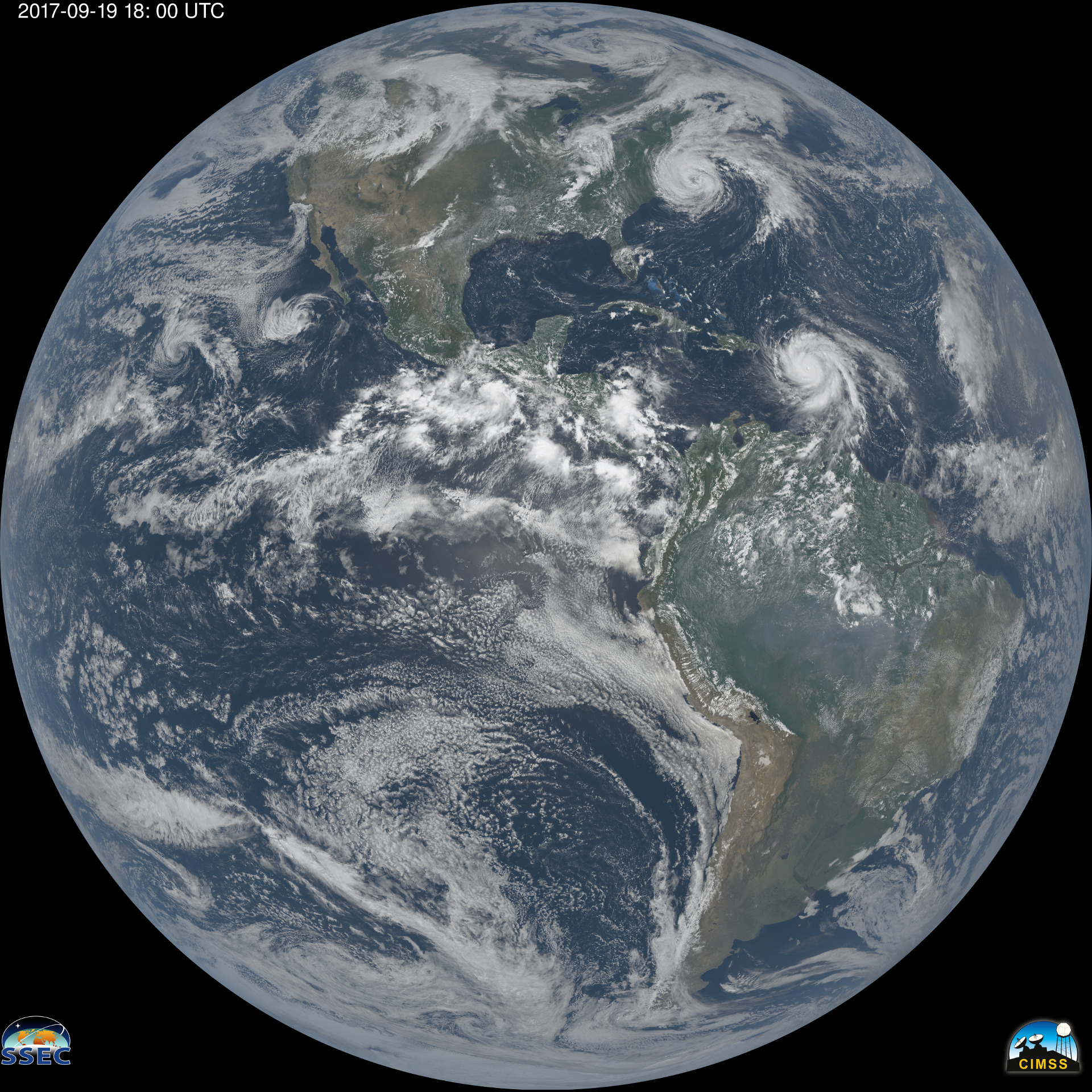
Figure caption: Full disk “natural true color” ABI image (pre-operational data) from September 19, 2017 at 18:00 UTC (2:00pm EDT) featuring Hurricanes Jose (off New England) and Maria (approaching the Caribbean). Color images such as this are generated with a combination of spectral bands to mimic the natural coloring of Earth as seen from space. Image courtesy of Kaba Bah (UW-Madison/CIMSS).
ITEMS FOR THE DIVISION CHIEF, CoRP:
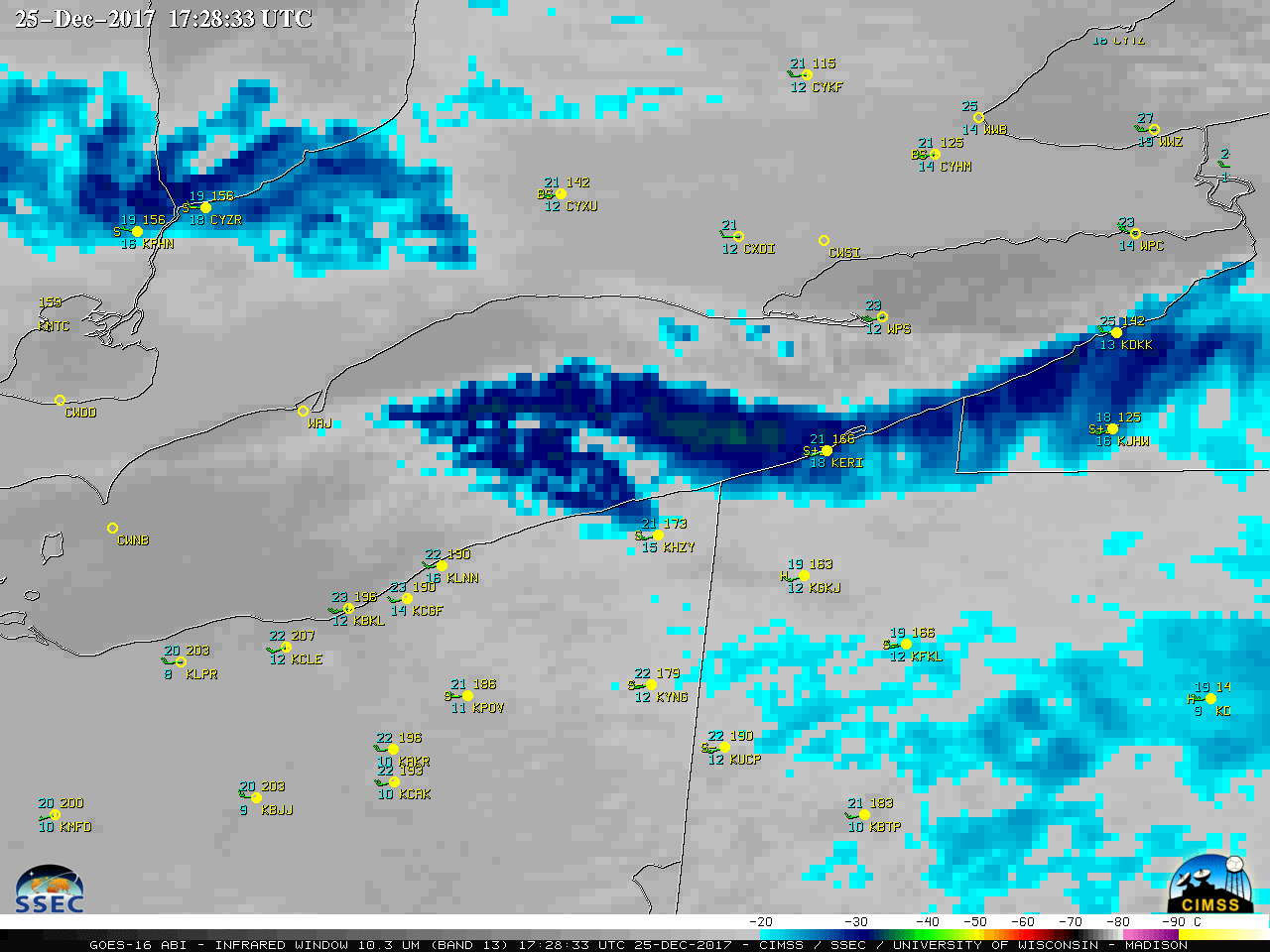
Satellite Imagery of Record-Setting Lake Effect Snow Event at Erie, Pennsylvania: The Cooperative Institute for Meteorological Satellite Studies (CIMSS) Satellite Blog was updated with a post documenting the record-setting lake effect snow event at Erie, Pennsylvania during December 25-27, 2017 (http://cimss.ssec.wisc.edu/goes/blog/archives/26473). A Geostationary Operational Environmental Satellite (GOES)-16 Mesoscale Sector provided 1-minute imagery during much of the event, which showed the evolution of the dominant lake effect snow bands which produced a storm total snowfall of 65.1 inches at Erie (which also set a new 2-day snowfall record for the state of Pennsylvania). (S. Bachmeier, CIMSS, 608-263-3958)
 (Click image to enlarge)
Figure caption: GOES-16 "Clean" Infrared Window (10.3 µm) image at 17:28:33 UTC on December 25, 2017, showing the lake effect snow band that was producing heavy snow at Erie, Pennsylvania (KERI).
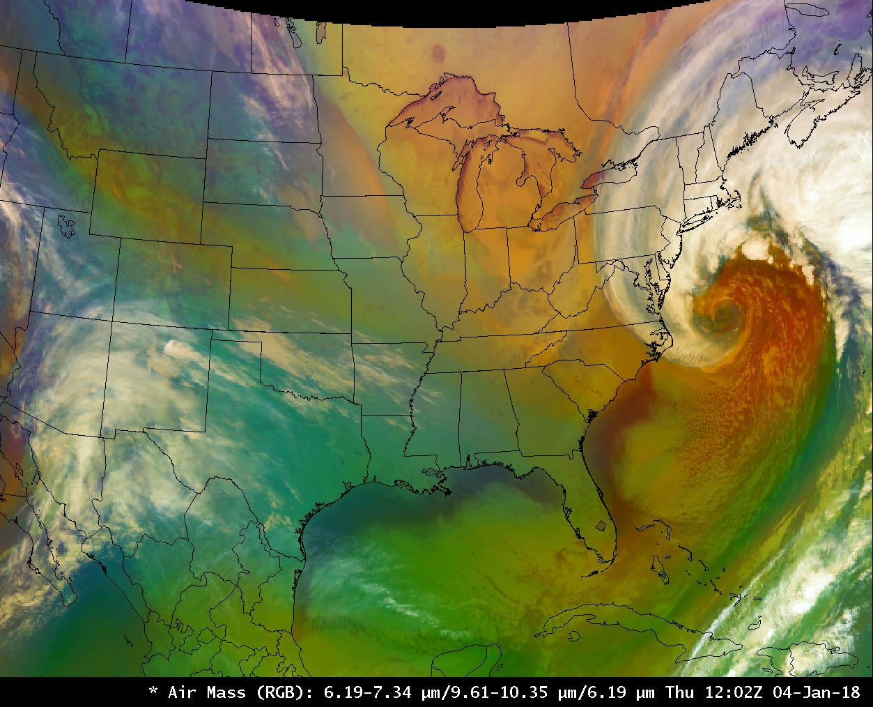
Satellite Imagery of Rapidly-Intensifying Eastern US Winter Storm: The Cooperative Institute for Meteorological Satellite Studies (CIMSS) Satellite Blog was updated with two posts documenting the rapidly-intensifying Eastern US winter storm on January 3-4, 2018 (http://cimss.ssec.wisc.edu/goes/blog/?s=explosive+cyclogenesis). Images and animations of Geostationary Operational Environmental Satellite (GOES)-16, Suomi National Polar-orbiting Partnership (NPP) Visible Infrared Imaging Radiometer Suite (VIIRS) and Landsat-8 showed the development of the storm, as well as some of the resulting snow and ice accumulations in the Deep South. (S. Lindstrom, CIMSS, 608-263-4425, S. Bachmeier, CIMSS)
 (Click image to enlarge)
Figure caption: GOES-16 Airmass Red-Green-Blue (RGB) product at 12:02 UTC on January 4, 2018.
VISITORS:
NEXT WEEK:
LOOKING AHEAD:
| Archived Weeklies Page | Submit a report item |