[ Archive ]
| CIMSS-NOAA Weekly Report [ Archive ] |
ASPB AND CIMSS WEEKLY HIGHLIGHTS FOR THE WEEK ENDING APRIL 20, 2018
IN THE PRESS:
ITEMS FOR THE ADMINISTRATOR:
ITEMS FOR THE ASSISTANT ADMINISTRATOR:
ITEMS FOR THE OFFICE DIRECTOR, STAR:
Manuscript on Advanced IR Sounder published in BAMS: An overview paper on advanced infrared sounder development and applications, titled "Satellite based atmospheric infrared sounder development and applications", has been published in the Bulletin of American Meteorological Society (vol 99, No.03). Co-authors are W. Paul Menzel (CIMSS), Timothy J. Schmit (STAR), Jun Li (CIMSS) and Peng Zhang (CMA). (Jun Li, 608-262-3755, Jun.Li@ssec.wisc.edu).
American Meteorological Society Award: The Banner I. Miller Award is presented for an outstanding contribution to the science of hurricane and tropical weather forecasting published in a journal with international circulation during the 48 months prior to the deadline for nominations. The biennial award is presented at each Conference on Hurricanes and Tropical Meteorology. The 33rd conference met this week in Ponte Vedra, Florida, and announced this year's award winners: Jason Dunion (University of Miami Cooperative Institute for Marine and Atmospheric Studies), Christopher Thorncroft (University of Albany), and Christopher Velden (University of Wisconsin Cooperative Institute for Meteorological Satellite Studies) for their paper "The Tropical Cyclone Diurnal Cycle of Mature Hurricanes". (C. Velden, CIMSS, 608-262-9168)
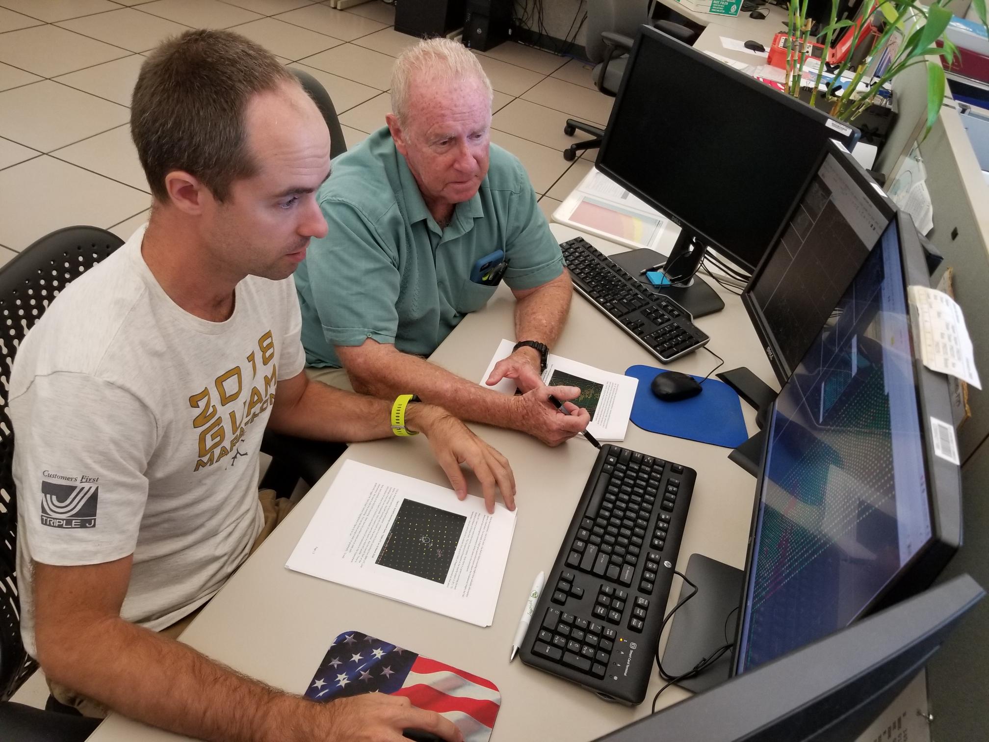
Workshops Held at NWS Guam Forecast Office: During the week of 16 April 2018, four scientists from the Cooperative Institute for Meteorological Satellite Studies (CIMSS), Kathy Strabala, Scott Lindstrom, Liam Gumley, and Jordan Gerth, led two, two-day workshops at the National Weather Service (NWS) forecast office in Barrigada, Guam. The workshops contained presentations and lab exercises to familiarize the meteorologists at the Guam field office with the data collected from an on-site L/X-band receiving antenna. The goal of the workshop was to increase the use of polar-orbiting satellite imagery and products, particularly from the Joint Polar Satellite System (JPSS), in the tropics. The University of Wisconsin partnered with NOAA to install the antenna at the field office in 2017, which provides imagery directly to the Advanced Weather Interactive Processing System (AWIPS), the only such configuration in the country. (J. Gerth, CIMSS, 608-263-4942)
 (Click image to enlarge)
Figure caption: NWS Guam meteorologist Brandon Aydlett and Warning Coordination Meteorologist (WCM) Chip Guard review a set of profiles from the NOAA Unique Combined Atmospheric Processing System (NUCAPS) in AWIPS on 20 April 2018.
NOAA-20 Enterprise Cloud Mask Beta Maturity Review: The Beta Maturity Review for the NOAA-20 Enterprise Cloud Mask (ECM) was held this week. This was the first review of a NOAA-20 Enterprise Algorithm. The ECM passed this review and is now declared Beta and will be made available to users. The review noted some major issues that need to be addressed. First, roughly one third of the ECM files are not being made available on any given day. Secondly, there remains a large discrepancy in the ECM results generated between STAR and NESDIS Operations. The solving of these issues must occur quickly as they pose a risk to other Enterprise Algorithms that rely on the ECM. The Provisional Review for the ECM and the Beta Reviews for the other Enterprise Cloud Products will be held in July 2018. (A. Heidinger, E/RA2, 608-263-6757, andrew.heidinger@noaa.gov)
ITEMS FOR THE DIVISION CHIEF, CoRP:
Seminar presented at Leech Lake Tribal College: A seminar was presented by Bob Rabin at the Leech Lake Tribal College (Minnesota). The seminar included current research using data from the GOES-16 Advanced Baseline Imager and Geostationary Lightning Mapper. (R. Rabin, NOAA/NSSL and CIMSS, 608-264-5325/405-366-0583)
Visit to National Weather Service Forecast Office: John Cintineo (Cooperative Institute for Meteorological Satellite Studies, CIMSS), Justin Sieglaff (CIMSS), and Mike Pavolonis (NOAA/NESDIS/STAR) visited the National Weather Service (NWS) Weather Forecast Office (WFO) in Milwaukee/Sullivan, WI on April 17, 2018. The purpose of the visit was to conduct a training and discussion session on the NOAA/CIMSS ProbSevere (“probability of severe”) model. The ProbSevere session, which was part of a special day at the Milwaukee WFO dedicated to training and research and development, included an extended discussion on current and future ProbSevere capabilities. Nearly every forecaster at the Milwaukee WFO was able to participate and the discussions were extremely productive. This severe weather season, the Milwaukee WFO will evaluate an enhanced version of ProbSevere that includes hazard specific (wind, hail, tornado) predictions. Targeted product evaluation exercises, with local NWS offices, and in-person user engagement are an important part of the research process. (M. Pavolonis, E/RA2, 608-263-9597, Mike.Pavolonis@noaa.gov)
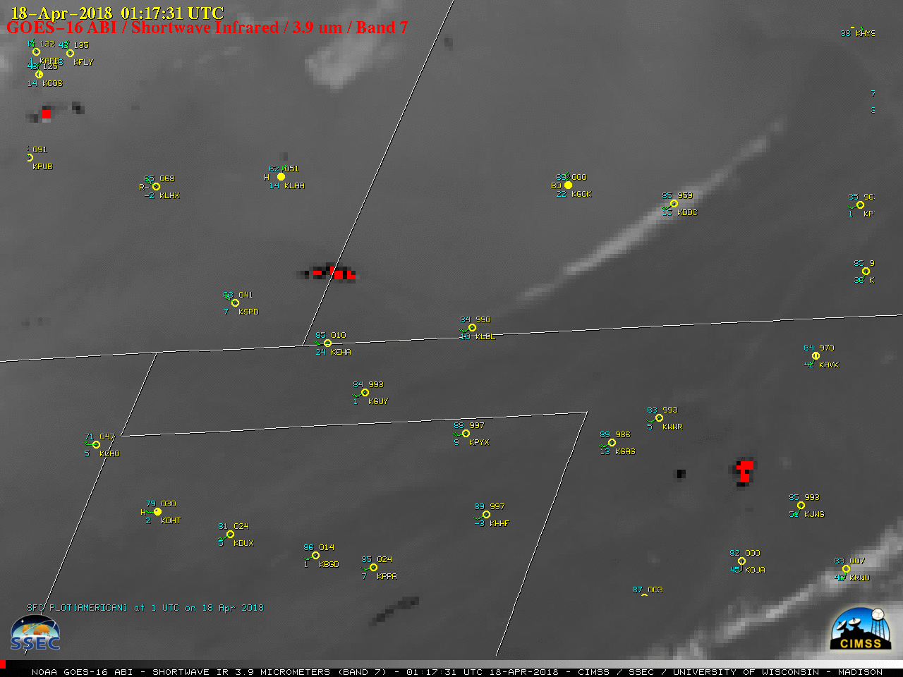
Satellite Images of Large Grass Fires in the Southern Plains: The Cooperative Institute for Meteorological Satellite Studies (CIMSS) Satellite Blog was updated with a post showing a variety of satellite images of large grass fires in the Southern Plains on April 17, 2018 (http://cimss.ssec.wisc.edu/goes/blog/archives/27795). Geostationary Operational Environmental Satellite (GOES)-16 images at 1-minute intervals displayed the rapid wind-driven growth of a few of the larger fires on April 17, and NOAA-20 Visible Infrared Imaging Radiometer Suite (VIIRS) images showed nighttime visible and thermal signatures of some of the fires on April 18. Moderate Resolution Imaging Spectroradiometer (MODIS) and Landsat-8 images showed signatures of some of the more prominent burn scars on April 18 and 19. (S. Bachmeier, CIMSS, 608-263-3958, W. Straka, CIMSS)
 (Click image to enlarge)
Figure caption: GOES-16 Shortwave Infrared (3.9 µm) image, with plots of surface reports. Thermal signatures of 2 prominent wildfires (red pixels) are seen for the Badger Hole Fire along the Colorado/Kansas border and the Rhea Fire in northwest Oklahoma.
VISITORS:
NEXT WEEK:
LOOKING AHEAD:
| Archived Weeklies Page | Submit a report item |