[ Archive ]
| CIMSS-NOAA Weekly Report [ Archive ] |
ASPB AND CIMSS WEEKLY HIGHLIGHTS FOR THE WEEK ENDING JUNE 8, 2018
IN THE PRESS:
SSEC and CIMSS Scientists in the News: Scientists at the University of Wisconsin-Madison (UW) Space Science and Engineering Center (SSEC) and the Cooperative Institute for Meteorological Satellite Studies (CIMSS) provide expert commentary, interviews, and imagery to news media. In the news this week: 1) UW News and SSEC News published stories on NCEI scientist Jim Kossin’s new study in Nature on June 6 showing that some hurricanes are moving more slowly, spending increased time over land and leading to catastrophic local rainfall and flooding (http://www.ssec.wisc.edu/news/articles/10934, https://news.wisc.edu/hurricanes-are-slowing-down-and-thats-bad-news/); 2) UW News and SSEC News published stories on SSEC scientist Shane Hubbard’s natural disaster and flood mitigation strategies for San Juan, Puerto Rico, before and after Hurricane Maria (https://news.wisc.edu/uw-collaboration-builds-resilience-in-the-wake-of-hurricane-maria/, http://www.ssec.wisc.edu/news/articles/10900); 3) These and other stories were picked up by news outlets from The Washington Post to Popular Mechanics and National Geographic to The Weather Channel and can be found in SSEC in the News (http://www.ssec.wisc.edu/news/articles/category/ssec-in-the-news). (J. Phillips, SSEC, 608-262-8164, S. Hubbard, CIMSS, J. Kossin, NCEI/NOAA, R. Kohrs, SSEC).
 (Click image to enlarge)
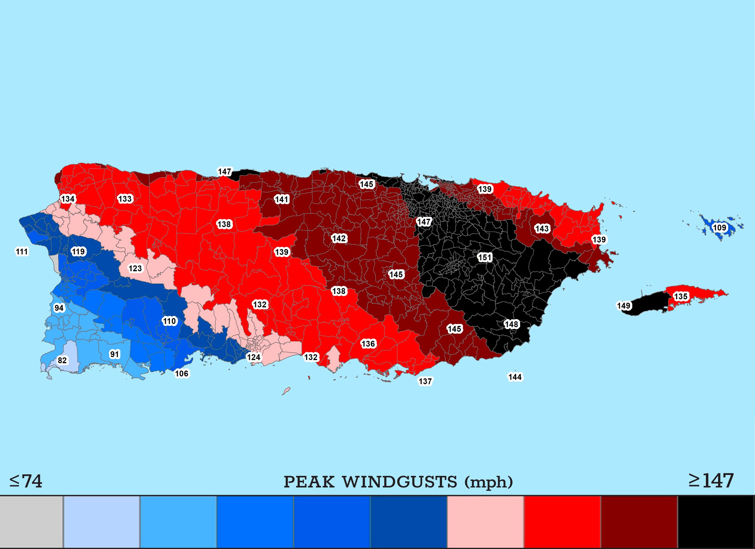
Figure caption: Based on the likely track for Hurricane Maria, SSEC scientist Shane Hubbard produced a map of estimated windspeeds, representing the estimated peak winds within each of Puerto Rico’s census tracts. Local effects (e.g., topography, buildings, trees, open terrain) will impact speeds locally. Credit: Shane Hubbard.
SSEC and CIMSS Scientists in Social Media: Scientists at the University of Wisconsin-Madison (UW) Space Science and Engineering Center (SSEC) and the Cooperative Institute for Meteorological Satellite Studies (CIMSS) provide expert commentary, interviews, and imagery to social media. 1) CIMSS Satellite Blog posts covered the eruption of Guatemala’s Fuego volcano, American Airlines flight 1897 that encountered convection and damaging hail, and Aletta, the first hurricane of the eastern Pacific Ocean season. Accompanying images and animations were derived from Geostationary Operational Environmental Satellite (GOES)-16 Advanced Baseline Imager (ABI) and instruments on-board NOAA-20, such as the Visible Infrared Imaging Radiometer Suite (VIIRS) (http://cimss.ssec.wisc.edu/goes/blog/); 2) @UWSSEC, @UWCIMSS, and @CIMSS_Satellite Twitter accounts were active with tweets on blog post topics, hail storms in South Dakota, Saharan dust as seen from GOES-16 ABI, training and presentations at the Cooperative Research Program (CoRP) Symposium, and a CIMSS Natural Color image of preliminary, non-operational GOES-17 ABI on May 31, 2018, to name a few. (M. Gunshor, CIMSS, S. Bachmeier, CIMSS, S. Lindstrom, CIMSS, J. Phillips, SSEC, R. Kohrs, SSEC, T. Schmit, E/RA2, 608-263-0291, tim.j.schmit@noaa.gov)
 (Click image to enlarge)
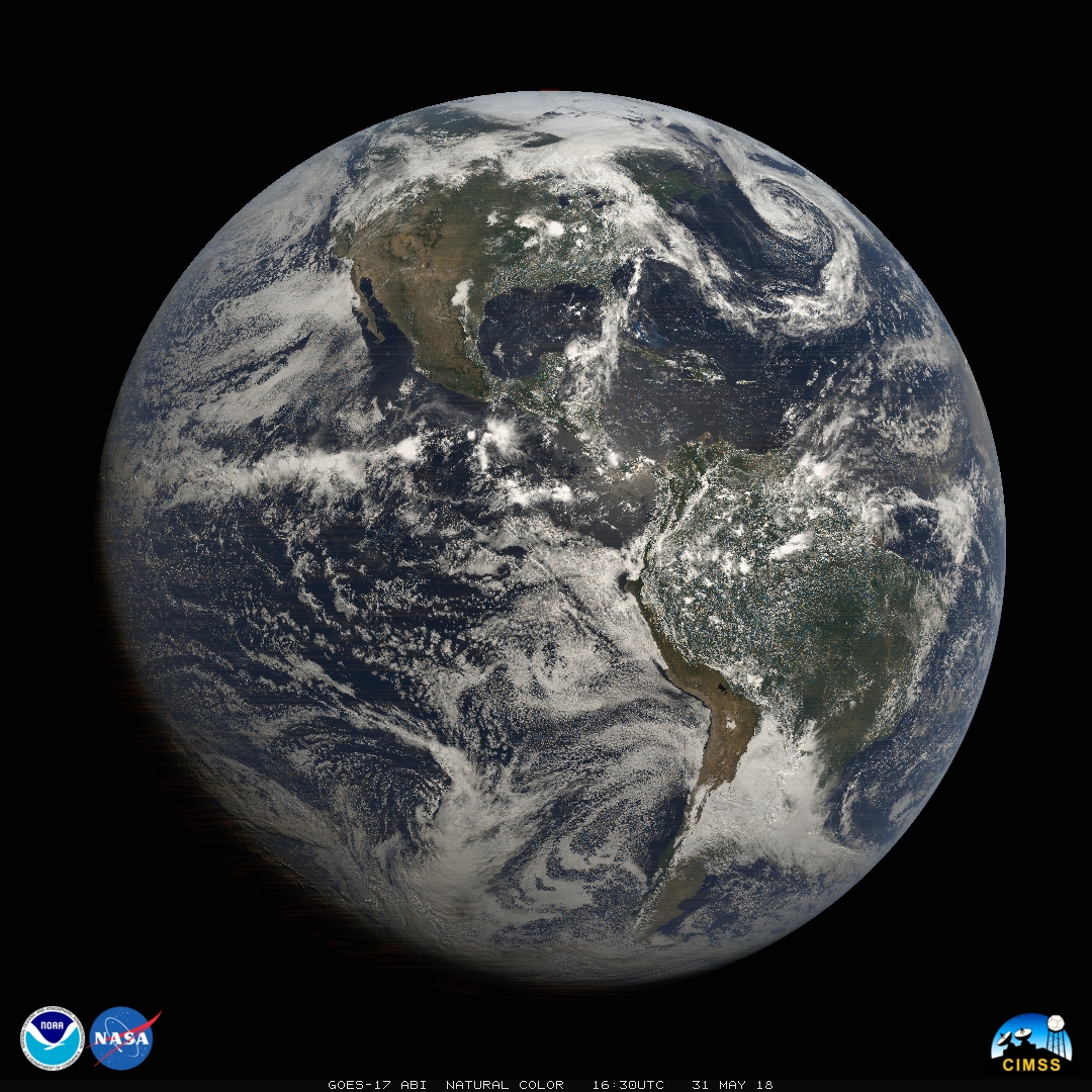
Figure caption: While GOES-17 ABI is still undergoing post-launch testing, preliminary non-operational visible data look gorgeous in this "CIMSS natural color" composite image from May 31 at 16:30 UTC. Image made using blue, red, and near-IR veggie band. Image Credit: Mat Gunshor
ITEMS FOR THE ADMINISTRATOR:
ITEMS FOR THE ASSISTANT ADMINISTRATOR:
ITEMS FOR THE OFFICE DIRECTOR, STAR:
CIMSS Hosts Annual CoRP Symposium: The 2018 Cooperative Research Program Symposium was held 6-7 June 2018 at the University of Wisconsin—Madison, hosted by the Cooperative Institute for Meteorological Satellite Studies. The theme for this year's symposium was "Turning NOAA Science into Information for Societal Benefit." Sixty students, researchers, and professors from the NESDIS' Center for Satellite Applications and Research (STAR) cooperative institutes (also at Colorado State University, University of Maryland, and City College of New York) convened to hear talks and review posters presented by the students and recent graduates. The two days also included a panel presentation from current and former students who have moved into the work force discussing their career paths, an offering of some suggestions on how to communicate more effectively with peers and the general public, and a training session on understanding and using satellite data. Scott Lindstrom, CIMSS, and Tim Schmit, NOAA/ASPB, gave satellite training to about a dozen students. Following a lecture on the Advanced Baseline Imagery (ABI) and its capabilities and channels, the students were tasked to complete short laboratory exercises on weighting functions (principally for water vapor imagery) and on satellite interpretation, the latter using the CIMSS-developed Satellite Information and Familiarization Tool (SIFT). Brad Pierce gave an invited talk on the 2017 Lake Michigan Ozone Study at the CoRP Symposium. (P. Menzel, CIMSS, 608-263-4930, paulm@ssec.wisc.edu; S. Lindstrom, CIMSS, 608-263-4425; T. Schmit, E/RA2, 608-263-0291, tim.j.schmit@noaa.gov;R.B. Pierce, E/RA2, 608-890-1892, brad.pierce@noaa.gov)
 (Click image to enlarge)
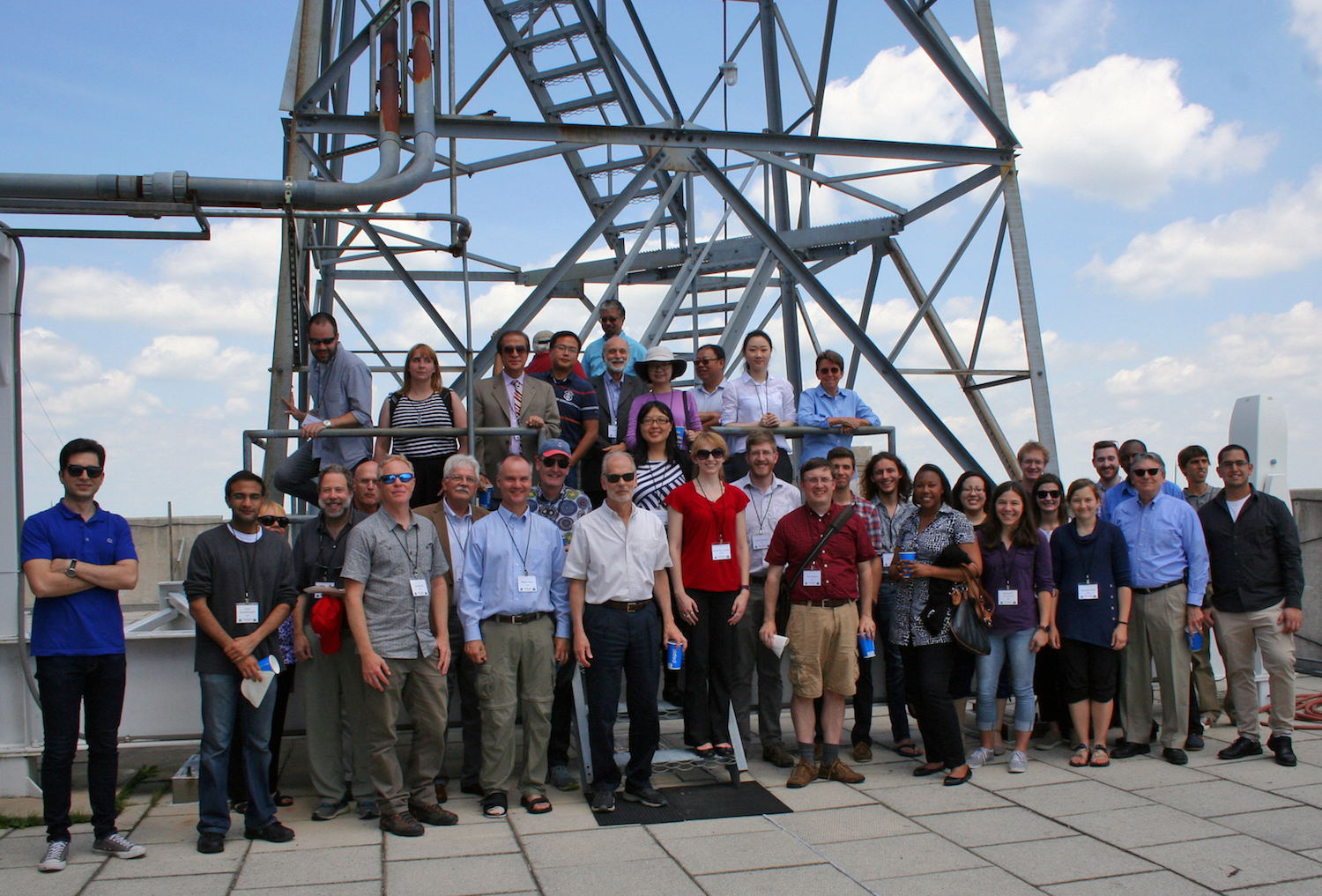
Figure caption: CoRP Symposium participants on the roof of the Atmospheric, Oceanic, and Space Science building, where CIMSS is located.
GOES-16 Cloud and Moisture Imagery Reach Full Validation Maturity: An Advanced Baseline Imager (ABI) Full Validation Peer Stakeholder - Product Validation Review (PS-PVR) was held on June 1, 2018 for Geostationary Operational Environmental Satellite (GOES)-16 Cloud and Moisture Imagery (CMI) and L1b Radiances. On June 5, 2018 it was announced that CMI has reached Full Validation maturity, successfully passing the review, along with Level 1b radiances. Mat Gunshor of the Cooperative Institute for Meteorological Satellite Studies (CIMSS) in Wisconsin and Tim Schmit of NOAA/NESDIS/STAR gave presentations on CMI post-launch validation activities, current status, and the path forward on remaining issues. (M. Gunshor, CIMSS, 608-263-1146, T. Schmit, E/RA2, 608-263-0291, tim.j.schmit@noaa.gov).
 (Click image to enlarge)
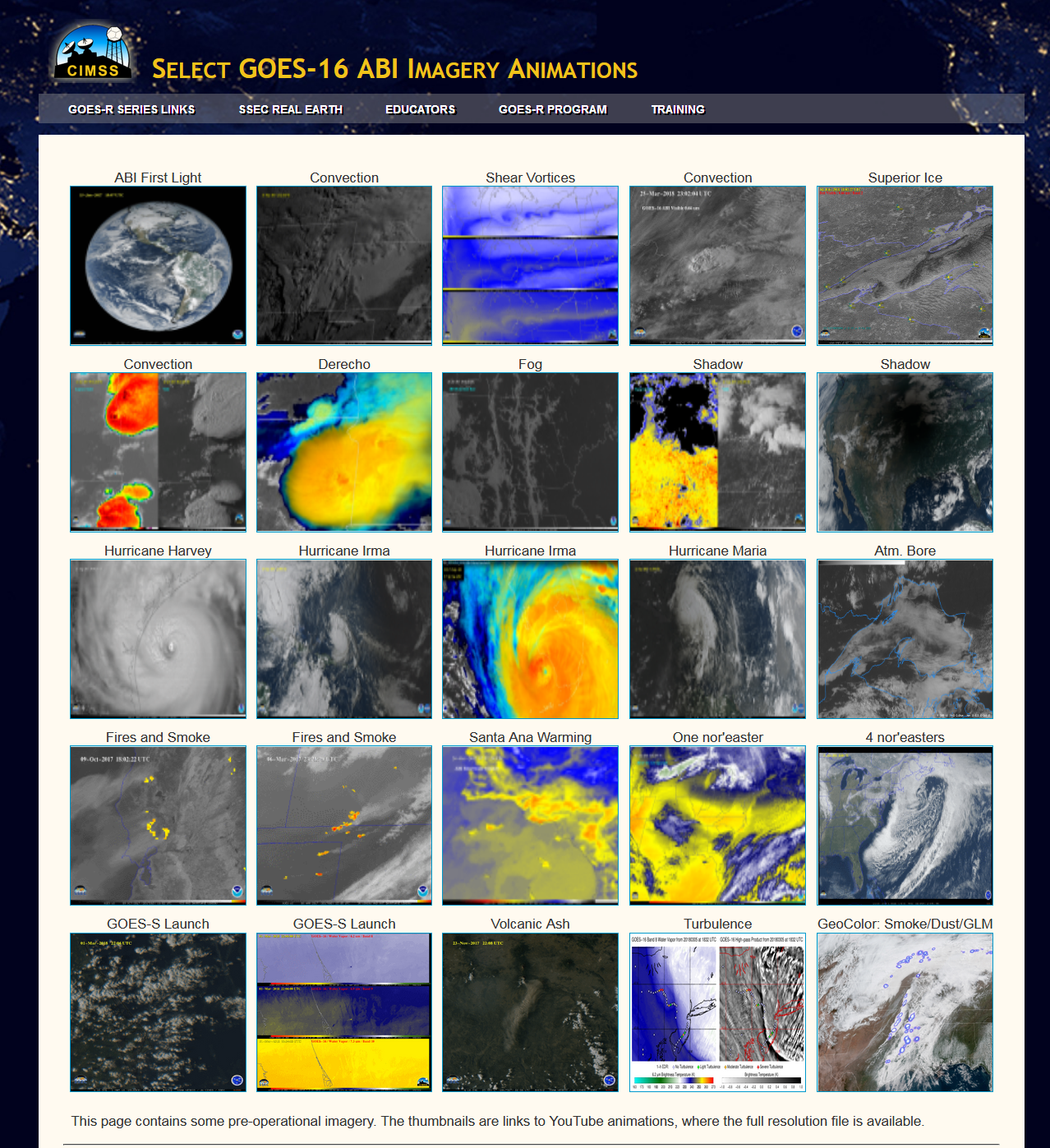
Figure caption: ABI animations that capture a wide range of environmental phenomena: https://cimss.ssec.wisc.edu/goes/abi/youtube/ABI_loops25.html.
CGMS 46 Presentations: The 46th meeting of the Coordination Group for Meteorological Satellites (CGMS) met this week in Bengaluru, India. Andrew Heidinger and Steve Wanzong participated remotely in the Satellite Data and Products Sections. Both represented different CGMS Working Groups. Heidinger presented on the status of the International Cloud Working Group (ICWG) whose next meeting is in November in Madison, Wisconsin. Wanzong presented the highlights of the recent International Winds Working Group (IWWG) held this April in JeJu Island, South Korea. He also presented a summary of the IWWG presentation during the CGMS Plenary. All presentations were given remotely. The CGMS meetings are important in that they generate actions to the Working Groups which prioritize their activities in the coming year. (A. Heidinger, E/RA2, 608-263-6757, andrew.heidinger@noaa.gov, S. Wanzong, CIMSS, 608-263-1950)
Review Paper Discussing Rapid Onset Flash Droughts Published: A manuscript entitled “Flash droughts: A review and assessment of the challenges imposed by rapid-onset droughts in the United States” by Jason Otkin et al. was published in the May issue of the Bulletin of the American Meteorological Society. This paper provides an overview of recent research on flash droughts and presents a preferred definition for these features of the climate system that focuses on their rate of development rather than their duration. There are two primary reasons for favoring the intensification approach over the duration approach. First, longevity and impact are fundamental characteristics of drought. Thus, short-term events lasting only a few days and having minimal impacts are inconsistent with the general understanding of drought and therefore should not be considered flash droughts. Second, by focusing on their rapid rate of intensification, the proposed flash drought definition highlights the unique challenges faced by vulnerable stakeholders who have less time to prepare for its adverse effects when they develop so quickly. It is hoped that this article will lead to a consistent definition for flash drought that focuses on its rate of intensification. (J. Otkin, CIMSS, 608-265-2476)
Regional Coordinator for NOAA Great Lakes Regional Collaboration Team Visit: Jennifer Day, Regional Coordinator for the NOAA Great Lakes Regional Collaboration Team (GLRCT), and team member Doug Kluck, NOAA Regional Climate Services Director, Central Region visited the Cooperative Institute for Meteorological Satellite Studies (CIMSS) to meet Advanced Satellite Products Branch (ASPB) and CIMSS staff and management to discuss NOAA activities in the Great Lakes Region (R.B. Pierce, E/RA2, 608-890-1892, brad.pierce@noaa.gov)
ITEMS FOR THE DIVISION CHIEF, CoRP:
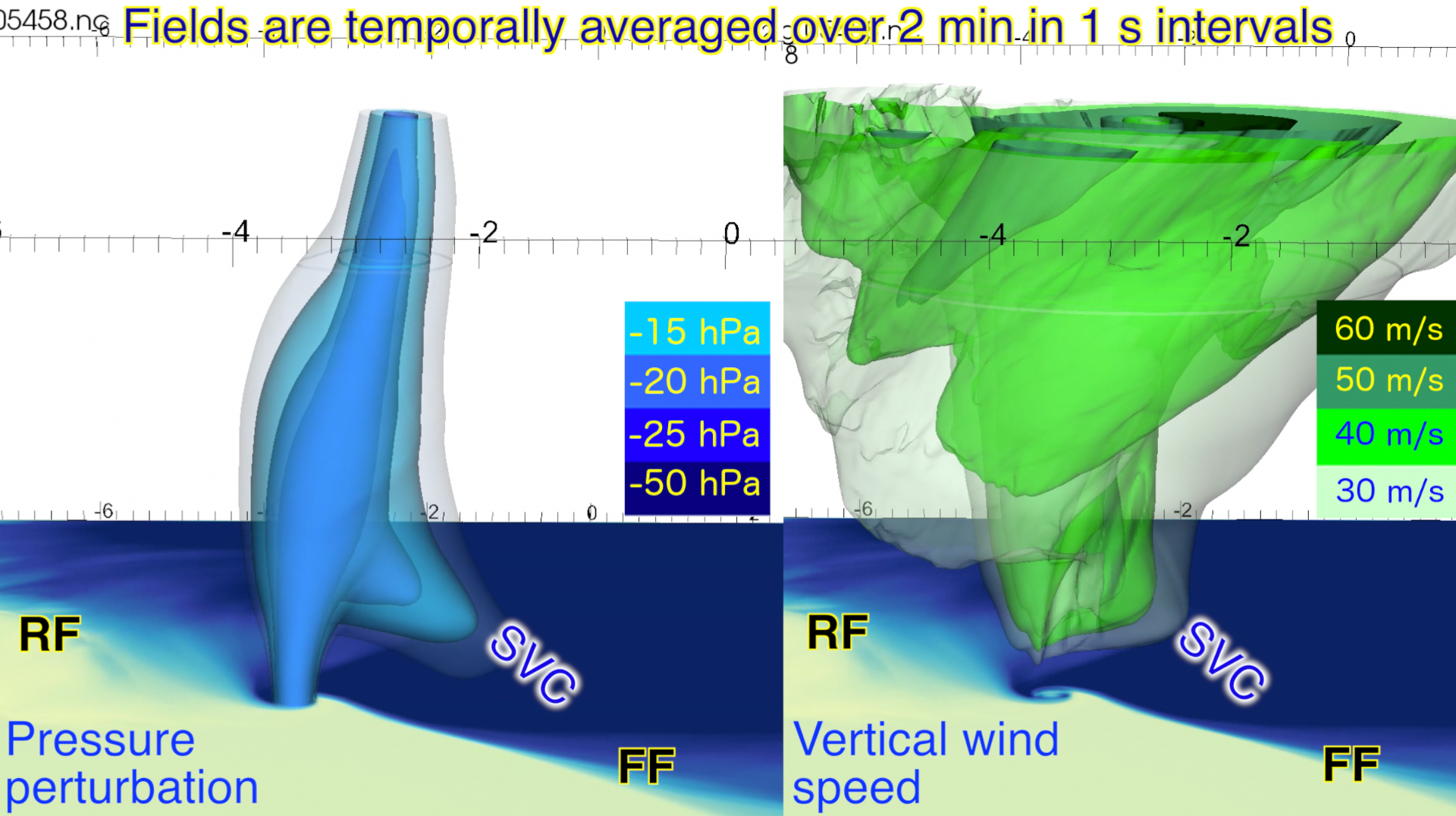
CIMSS Scientist presents at Blue Waters Supercomputer Symposium: Cooperative Institute for Meteorological Satellite Studies (CIMSS) scientist Leigh Orf presented "Understanding the Development and Evolution of Violent Tornadoes in Supercell Thunderstorms" at the fifth annual Blue Waters Symposium in Sunriver, OR. A video of the presentation is available at https://youtu.be/UTg9teBZsK0. (L. Orf, CIMSS, 608-890-1983)
 (Click image to enlarge)
Figure caption: The relationship between the newly identified streamwise vorticity current (SVC), pressure, and updraft fields is presented, showing that the SVC is correlated with a drop in pressure and lowering of the mesocyclone, helping to create and maintain an EF5 tornado.
Presentation at JCSDA 16th Workshop on Satellite Data Assimilation: Tom Greenwald gave a presentation titled "Optimizing the CRTM for Improved Performance of All-Sky Radiance Data Assimilation" at the 16th Annual Joint Center for Satellite Data Assimilation (JCSDA) Science and Technical Workshop in Boulder, CO, 30 May – June 1. By significantly improving the efficiency of scattering calculations in the Community Radiative Transfer Model (CRTM), the runtime for a Hybrid 4D EnVar data assimilation experiment using all-sky Global Precipitation Measurement Microwave Imager (GMI) observations was reduced by almost 20% as compared to using the most recent version of the CRTM. (T. Greenwald, CIMSS, 608-263-3629)
Talk on hyperspectral infrared sounder assimilation given at AOGS: Jun Li attend the Asia Oceania Geoscience Society (AOGS) 15th Annual Meeting held 3-8 June 2018 in the Hawaii Convention Centre (HCC), Honolulu, Hawaii, and gave an invited talk titled "Challenges and progress on the assimilation of hyperspectral infrared radiances in cloudy skies". (Jun Li, 608-262-3755, Jun.Li@ssec.wisc.edu)
Eastern Snow Conference: The 75th Annual Eastern Snow Conference Meeting was held at the NOAA Center for Weather and Climate Prediction in College Park, Maryland, June 5-8 2018. Cooperative Institute for Meteorological Satellite Studies (CIMSS) research scientist Yinghui Liu participated the conference, and presented a poster on the "current status of GOES-R fractional snow cover product". (Y. Liu, CIMSS, 608-265-8620)
NWS Pacific Region Receives Additional Satellite Data: From 4 to 8 June 2018, Jordan Gerth of the Cooperative Institute for Meteorological Satellite Studies (CIMSS), visited the National Weather Service (NWS) Pacific Region Headquarters (PRH) and Honolulu Forecast Office (HFO) in Honolulu, Hawaii, to introduce new polar-orbiting satellite imagery and products to operational meteorologists. The use-inspired science data created with the Community Satellite Processing Package (CSPP) was integrated into the Advanced Weather Interactive Processing System (AWIPS). The raw data is captured and processed on antennas that NOAA funded to mitigate the risk of a gap in the weather satellite constellation and enhance NWS operations. These additions were particularly timely due to the ongoing eruption of the Kilauea volcano, the beginning of hurricane season, and complications with the imager on the latest Geostationary Operational Environmental Satellite (GOES-17). (J. Gerth, CIMSS, 608-263-4942)
VISITORS:
NEXT WEEK:
LOOKING AHEAD:
| Archived Weeklies Page | Submit a report item |