[ Archive ]
| CIMSS-NOAA Weekly Report [ Archive ] |
ASPB AND CIMSS WEEKLY HIGHLIGHTS FOR THE WEEK ENDING AUGUST 10, 2018
IN THE PRESS:
ITEMS FOR THE ADMINISTRATOR:
ITEMS FOR THE ASSISTANT ADMINISTRATOR:
ITEMS FOR THE OFFICE DIRECTOR, STAR:
ITEMS FOR THE DIVISION CHIEF, CoRP:
Manuscript on geostationary advanced infrared sounder for local severe storm forecast published: A manuscript titled "Value-added Impact of Geostationary Hyperspectral Infrared Sounders on Local Severe Storm Forecasts — via a Quick Regional OSSE", has been published in Advances in Atmospheric Sciences, 35(10): 1217 - 1230. Co-authors are Zhenglong Li, Jun Li, Pei Wang, Agnes Lim, Jinlong Li (CIMSS), Timothy J. Schmit (STAR), Robert Atlas (AOML), Sid-Ahmed Boukabara (STAR), and Ross N. Hoffman (STAR). (Jun Li, CIMSS, tel: 608-262-3755, Jun.Li@ssec.wisc.edu)
GOES-16 Training at the 14th AMS Symposium on Urban Environment (NYC): Scott Lindstrom, CIMSS, gave a 2-hour presentation on Satellite-derived estimates of vertical profiles of temperature and moisture, including convective stability indices and total Precipitable water at a Workshop at the 14th AMS Symposium on Urban Environment (combined with the 10th International Conference on Urban Climate (ICUC)). 11 students learned about GOES-16 Baseline Products and about Polar Satellite products (including NUCAPS, MIRS and MIMIC), and where to find them online. (Scott Lindstrom, CIMSS, 608 263 4425)
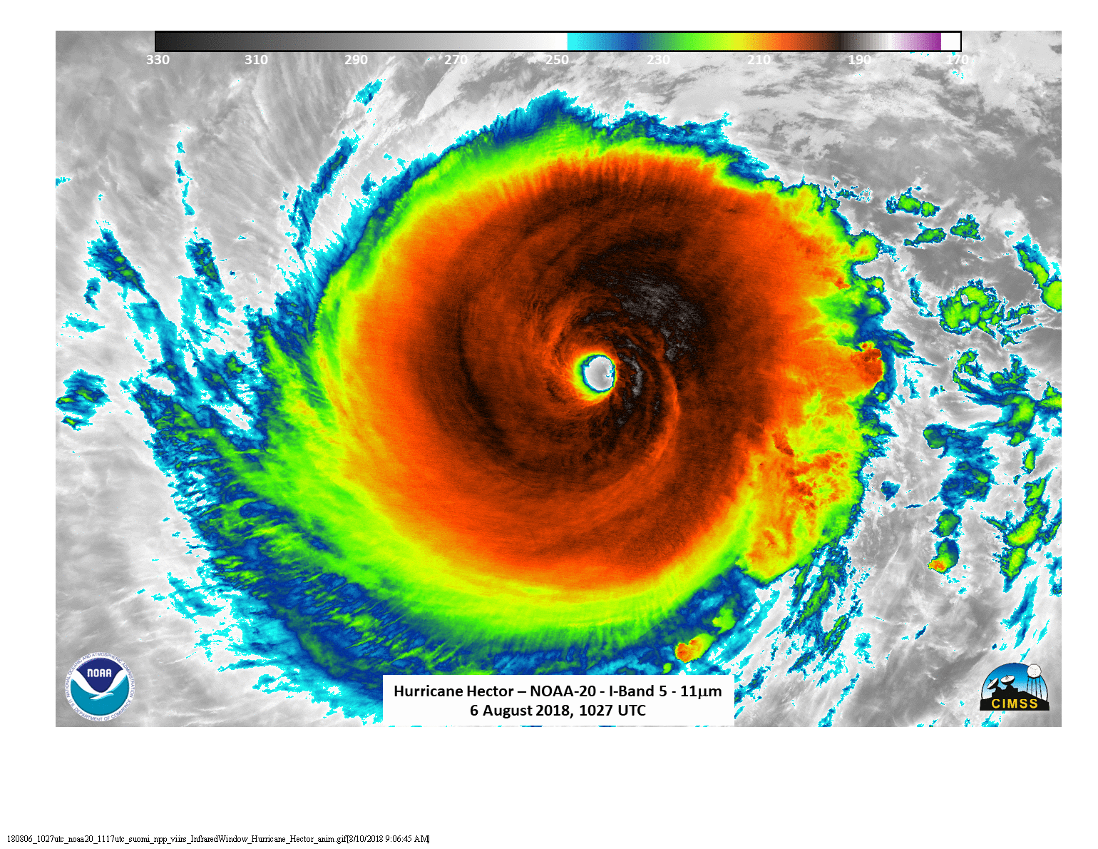
SSEC and CIMSS Scientists in the News: SSEC and CIMSS Scientists in the News: Scientists at the University of Wisconsin-Madison (UW) Space Science and Engineering Center (SSEC) and the Cooperative Institute for Meteorological Satellite Studies (CIMSS) provide expert commentary, interviews, and imagery to news media. In the news this week: 1) In early August, the NOAA National Centers for Environmental Information released its 28th annual State of the Climate report for 2017. SSEC, CIMSS, and Department of Atmospheric and Oceanic Sciences authors contributed analyses and observations of global cloudiness, atmospheric circulation over Antarctica, and new techniques that use the latest GOES satellites to improve hurricane forecasts. SSEC News highlighted these contributions and other report highlights: https://www.ssec.wisc.edu/news/articles/11156. 2) CIMSS Satellite Blog contributors Scott Bachmeier and Scott Lindstrom published posts on the "Holy Fire in southern California as viewed by 4 GOES" (August 9), "Stereoscopic views of convection along the Texas Gulf Coast" (August 8), "Subtropical Storm Debby" (August 7), "Hurricane John" (August 7), "Hurricane Hector" (August 6), "Smoke from Mendocino complex fires in California" (August 4), "Alonsa, Manitoba EF-4 tornado" (August 3), "Transport of Saharan air layer dust across the Atlantic" (August 3). Read more at the CIMSS Satellite Blog: http://cimss.ssec.wisc.edu/goes/blog/.(J. Phillips, SSEC, 608-262-8164, S. Bachmeier, CIMSS, S. Lindstrom, SSEC)
 (Click image to enlarge)
Figure caption: NOAA-20 infrared window image showing well-defined eye of Hurricane Hector after reaching Category 4 intensity on 06 August 2018. Credit: William Straka, CIMSS.
VISITORS:
NEXT WEEK:
LOOKING AHEAD:
| Archived Weeklies Page | Submit a report item |