[ Archive ]
| CIMSS-NOAA Weekly Report [ Archive ] |
ASPB AND CIMSS WEEKLY HIGHLIGHTS FOR THE WEEK ENDING AUGUST 24, 2018
IN THE PRESS:
SSEC and CIMSS Scientists in the News: Scientists at the University of Wisconsin-Madison (UW) Space Science and Engineering Center (SSEC) and the Cooperative Institute for Meteorological Satellite Studies (CIMSS) provide expert commentary, interviews, and imagery to news media. In the news this week: 1) Members of Congress from Wisconsin toured SSEC and CIMSS this week to learn about important and innovative federally-funded research conducted at UW-Madison (https://news.wisc.edu/thank-you-dairy-much/. 2) CIMSS Satellite Blog contributors Scott Bachmeier and Scott Lindstrom provided extensive coverage of "Hurricane Lane" (August 22-23), "Flash flooding in Southern Wisconsin" (August 20), and "Typhoon Soulik in the northwest Pacific Ocean" (August 20. Read more at the CIMSS Satellite Blog (http://cimss.ssec.wisc.edu/goes/blog/). (J. Phillips, SSEC, 608-262-8164, S. Ackerman, SSEC/CIMSS, S. Bachmeier, CIMSS, S. Lindstrom, SSEC)
 (Click image to enlarge)
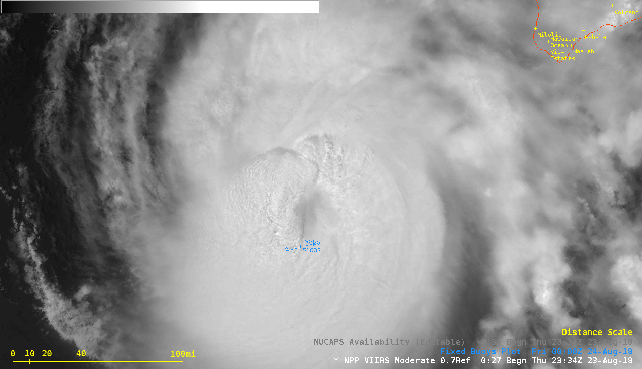
Figure caption: Suomi NPP VIIRS Day/Night Band (0.7 µm) image of Hurricane Lane at 2334 UTC on 23 August 2018. Credit: CIMSS.
ITEMS FOR THE ADMINISTRATOR:
ITEMS FOR THE ASSISTANT ADMINISTRATOR:
ITEMS FOR THE OFFICE DIRECTOR, STAR:
Key Satellite Products being used to Monitor Hurricane Lane: As Hurricane Lane threatens the Hawaiian Islands, the GOES-15 satellite is providing critical information in the form of multispectral satellite imagery and derived products. Two of the key products being employed liberally by operational forecasters at NOAA's Central Pacific Hurricane Center (CPHC) to analyze the current state of Lane and its environment as it approaches Hawaii are the Advanced Dvorak Technique (ADT) estimates of intensity, and vertical wind shear (VWS) analyses derived from high-density GOES atmospheric motion vectors. These two products were developed at the Cooperative Institute for Meteorological Satellite Studies (CIMSS) at the University of Wisconsin (UW), and are available in real time as part of the CIMSS satellite products hurricane demonstration site at http://tropic.ssec.wisc.edu/tropic.php. An example of their critical use in the analysis of Lane is an excerpt below from a CPHC public forecast discussion. (C. Velden, CIMSS, 608-262-9168; T. Olander, CIMSS, 608-265-8005)
WTPA42 PHFO 222100 TCDCP2 Hurricane Lane Discussion Number 33 NWS Central Pacific Hurricane Center Honolulu HI EP142018 1100 AM HST Wed Aug 22 2018 Lane continues to be a very impressive hurricane. As of the 1800 UTC analysis time, the cloud pattern had improved over the last several hours with clearing and warming in the eye, and convection becoming more symmetric around the eyewall. Satellite intensity estimates from PHFO, JTWC, and SAB were unanimous at 6.5, and the CIMSS-ADT had 6.3. Based on this, we elected to maintain Lane at 135 kt for this advisory. The UW-CIMSS shear analysis shows that Lane is located within an area of moderate southwesterly shear. The tropical cyclone is expected to begin moving under increasing shear in the coming days which is expected to start a long-awaited weakening trend. Around 72 hours or so, the shear is expected to weaken the core of the tropical cyclone enough to initiate more rapid weakening that is shown for the remainder of the forecast period.
Participation in NTIA Workshop on Spectrum: Jordan Gerth, of the Cooperative Institute for Meteorological Satellite Studies (CIMSS), attended the National Telecommunications and Information Administration (NTIA) Spectrum Management Training Course in Washington, DC, from 20 through 24 August 2018. Participants learned spectrum management authorities and principles, and discussed potential solutions to spectrum interference challenges. J. Gerth was the only NOAA-affiliated participant; other participants in the workshop were from agencies in the federal government, including the armed services and Office of Management and Budget (OMB). As part of the visit, J. Gerth met with NOAA personnel in the Herbert C. Hoover federal building where the Department of Commerce is located. Effective spectrum management is essential to NOAA’s ability to collect remote observations. (J. Gerth, CIMSS, 608-263-4942)
ITEMS FOR THE DIVISION CHIEF, CoRP:
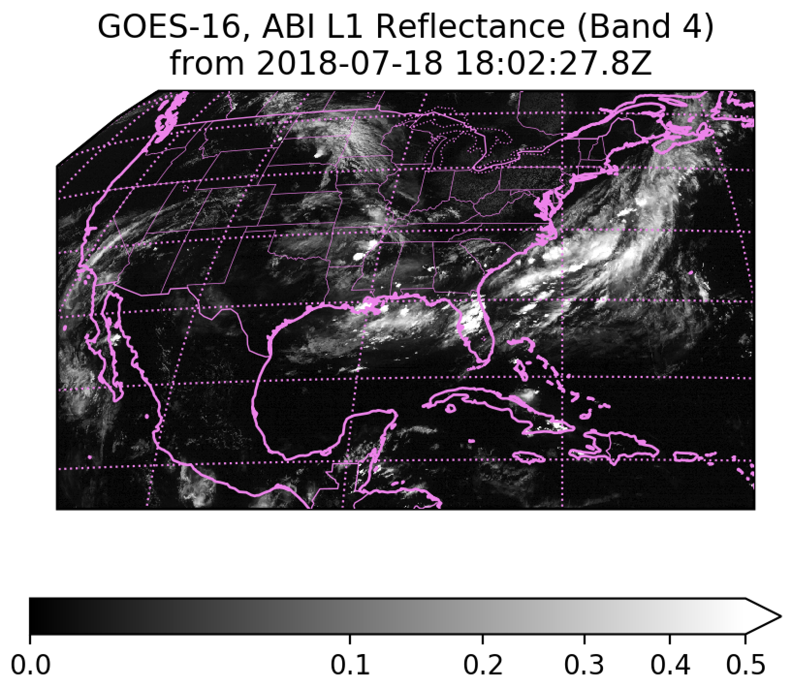
CSPP Geo Software Released: GOES Rebroadcast (GRB) Version 1.0: The Community Satellite Processing Package for Geostationary Data (CSPP Geo) team released Version 1.0 of the GRB software package. CSPP Geo software is widely used at GRB receiving stations throughout the GOES-16 receiving area. The GRB software is capable of processing direct broadcast data received from GOES-16, reconstructing products from all instruments as they were generated on the ground system, and plotting data from the Advanced Baseline Imager (ABI). This release adds provisional support for GOES-17 processing, various stability and performance improvements, and features requested by users. For more information on this release, and to obtain software and documentation, refer to http://cimss.ssec.wisc.edu/csppgeo/grb_v1.0.html. Contact csppgeo.issues@ssec.wisc.edu with any questions, comments, or technical support requests.
 (Click image to enlarge)
Figure caption: GOES-16 ABI quicklook image generated with CSPP Geo software.
VISITORS:
NEXT WEEK:
LOOKING AHEAD:
| Archived Weeklies Page | Submit a report item |