[ Archive ]
| CIMSS-NOAA Weekly Report [ Archive ] |
ASPB AND CIMSS WEEKLY HIGHLIGHTS FOR THE WEEK ENDING OCTOBER 19, 2018
IN THE PRESS:
SSEC and CIMSS Scientists in the News: Scientists at the University of Wisconsin-Madison (UW) Space Science and Engineering Center (SSEC) and the Cooperative Institute for Meteorological Satellite Studies (CIMSS) provide expert commentary, interviews, and imagery to news media and participate in events to promote science. In the news this week: 1) Jean Phillips delivered a lecture on data reuse and data citation for the Emerging Research Scholars program, a UW-Madison campus-wide series of workshops aimed at helping undergraduates develop essential data management skills. 2) The GOES-R Quarterly Newsletter highlighted SSEC scientist Scott Lindstrom's contributions to the CIMSS Satellite Blog (p.1) and workshops that he led in Mexico City and São Paulo,Brazil to teach experienced users about new GOES satellite data and products (p.4) (https://go.wisc.edu/qjbz5h). 3) CIMSS Satellite blog contributor Scott Bachmeier published posts on "Post-Tropical Cyclone Leslie making landfall in Portugal" (Oct. 13), "Blowing dust along the southwest coast of Greenland" (Oct. 14), and "Subtle signature of temperature advection seen in GOES-16 infrared imagery" (Oct. 18). Read more at the CIMSS Satellite Blog (http://cimss.ssec.wisc.edu/goes/blog/). 4) This week, WHNT News 19 of Huntsville, AL featured a VIIRS DNB image by William Straka III showing power outages after Hurricane Michael and WISC-TV, the CBS affiliate in Madison, published a story on connecting students with scientists at CIMSS and UW-Madison to promote careers in science. More media mentions at: https://www.ssec.wisc.edu/news/articles/category/ssec-in-the-news. (J. Phillips, SSEC, 608-262-8164, S. Bachmeier, CIMSS, S. Lindstrom, SSEC, W. Straka III, CIMSS)
 (Click image to enlarge)
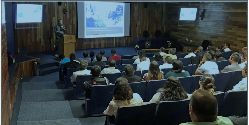
Figure: SSEC's Scott Lindstrom led the GOES-16 Workshop at Mexico’s National University last July to teach experienced users about new GOES satellite data, products, and techniques. Credit: Jim McNitt.
ITEMS FOR THE ADMINISTRATOR:
ITEMS FOR THE ASSISTANT ADMINISTRATOR:
ITEMS FOR THE OFFICE DIRECTOR, STAR:
AMSU Helps ReClassify Pre-Landfalling Alberto to a Tropical Storm: The first designated tropical disturbance of the year was originally classified as a Subtropical Storm (Alberto). However, careful post-analysis by the National Hurricane Center (NHC) has reclassified the system to a Tropical Storm. Instrumental in this change in the record books was an analysis of AMSU data that determined a warm-core thermal structure had developed. The just-released NHC Tropical Cyclone Report on Alberto highlights CIMSS' analyses: A transition from a subtropical to tropical storm occurred on 27 May, with the radius of maximum winds decreasing to about 40 n mi, the deep convection becoming more symmetric and collocated with the low-level center, and Alberto becoming more separated from the upper-level low over the Gulf of Mexico. In addition, as shown in analyses from the Cooperative Institute for Meteorological Satellite Studies, the cyclone developed a deeper warm core, an evolution which was evident in AMSU data in channels 5 (550 mb), 6 (350 mb), and 7 (200 mb) from 1411 UTC 27 May to 0129 UTC 28 May. Model analyses also detected the development of a deeper warm core. Based on these satellite and model data, Alberto is analyzed to have completed its transition from a subtropical storm to a tropical storm by 0000 UTC 28 May. While Alberto was carried operationally as a subtropical cyclone until it was declared tropical late on 29 May when the system was inland over western Tennessee, NHC forecasters recognized ambiguity in the storm’s structure and classification prior to landfall. A post-storm analysis, in particular of the above-mentioned AMSU data, is the basis for the current determination that Alberto became a tropical storm by 0000 UTC 28 May. (C. Velden, CIMSS, 608-262-9168; D. Herndon, CIMSS, 608-262-6741)
World Meteorological Organization Workshop on Volcanic Ash: A World Meteorological Organization (WMO) workshop on satellite-derived volcanic ash products was held in Catania, Italy 8-12 October 2018. The workshop was in support of the final phase of a WMO Sustained Coordinated Processing of Environmental Satellite Data for Nowcasting (SCOPE-Nowcasting) initiative to improve operational volcanic ash cloud detection and tracking in support of aviation safety and efficiency (volcanic ash is a major aviation hazard). Michael Pavolonis (NOAA/NESDIS/STAR), who leads the WMO volcanic ash initiative and chairs the WMO SCOPE-Nowcasting Executive Panel, attended the workshop. NOAA has an operational mandate to monitor for airborne volcanic ash 24/7, so this WMO activity is extremely relevant to the NOAA mission. The primary outcome of the workshop, which was attended by premier experts on satellite remote sensing of volcanic ash, is a report on the current state of volcanic ash products and a roadmap for overcoming key challenges that limit operational usage of satellite-derived products. The International Civil Aviation Organization (ICAO) will weigh the outcomes of the workshop while developing future requirements for aviation operations in volcanic ash contaminated airspace. Any changes to ICAO requirements may impact how Volcanic Ash Advisory Centers, including those within NOAA, operate. (M. Pavolonis, E/RA2, 608-263-9597, Mike.Pavolonis@noaa.gov)
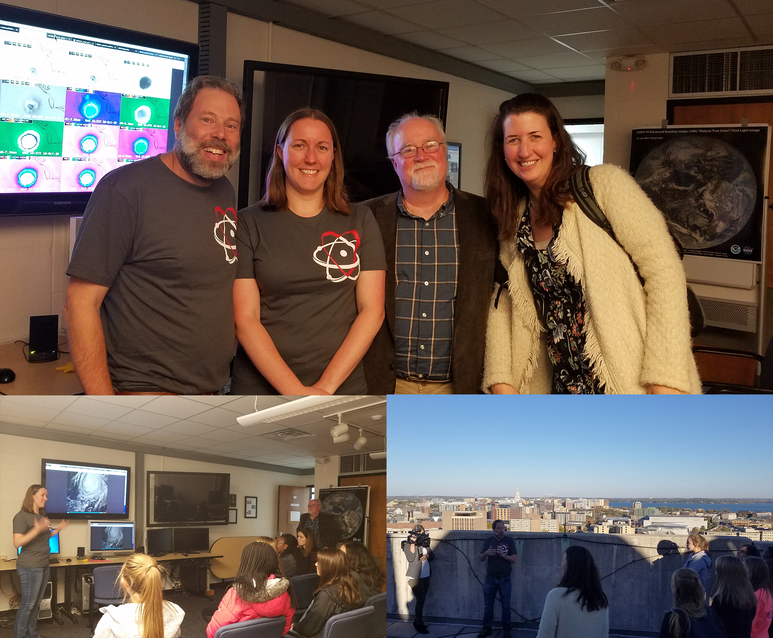
Science-A-Thon: Several scientists at the University of Wisconsin-Madison Space Science and Engineering Center (SSEC) and Cooperative Institute for Meteorological Satellite Studies (CIMSS) shared their "day of science" via social media this week in support of the Earth Science Women's Network (ESWN). To top it off, NOAA's Tim Schmit (aka @GOESGuy) and CIMSS's Sarah Griffin (@smgriffin00) along with SSEC Director Brad Pierce and Science-A-Thon founder Professor Tracey Holloway co-hosted local high school students visiting the Center to learn about weather satellites, tropical cyclones and the birthplace of satellite meteorology, while a local TV crew filmed the visit. The weather was perfect and students and TV crew were all impressed by GOES-16 capabilities and imagery. For more information see http://bit.ly/2EyPL39. (S. Griffin, CIMSS, 608-262-0986, T. Schmit, E/RA2, 608-263-0291, M. Mooney, CIMSS, 608-265-2123)
 (Click image to enlarge)
New AMS Committee on Radio Frequency Allocations: Jordan Gerth, of the Cooperative Institute for Meteorological Satellite Studies (CIMSS), will chair the new American Meteorological Society (AMS) Committee on Radio Frequency Allocations and lead the development of a new AMS policy statement on radio frequency allocations. Due to the importance of radio frequency allocations for observing the atmosphere and transmitting weather information, the new Committee, previously ad hoc, is organized under the Commission on the Weather, Water, and Climate Enterprise (CWWCE) Board on Enterprise Economic Development (BEED) and will coordinate with the AMS committees on satellite and radar meteorology. (J. Gerth, CIMSS, 608-263-4942)
ITEMS FOR THE DIVISION CHIEF, CoRP:
CIMSS Participation in Western Region Webinar on GOES-16/GOES-17: Chris Schmidt, Scott Lindstrom, and Jordan Gerth, all from the Cooperative Institute for Meteorological Satellite Studies (CIMSS), presented information on Fires and Fire Detection, Fog and Fog Detection, and wintertime supercooled water clouds, respectively, at a 1-hour webinar designed to focus on GOES-R Applications for the National Weather Service Western Region, which sponsored the webinar. Approximately 60 National Weather Service science and operations officers (SOOs) and forecasters attended the webinar. (C. Schmidt, CIMSS, 608 262 7973; S. Lindstrom, CIMSS, 608 263 4425; J. Gerth, CIMSS, 608 263 4942).
Presentation on NOAA research activities given at tribal college: Bob Rabin (NSSL) gave a presentation on NOAA research activities and operational products to a class in environmental science at the Keweenaw Bay Objiwa Tribal Community College in L'anse MI. Real-time GOES-16 satellite imagery and conditions of Lake Superior produced by the Great Lakes Environmental Research Laboratory (such as wave height, currents and water surface temperature) were highlighted. (R. Rabin, NOAA/NSSL and CIMSS, 608-264-5325/405-366-0583)
Samoa Meteorology Division Thankful for CIMSS: Following an engaging dialogue at the Asia-Oceania Meteorological Satellite Users’ Conference (AOMSUC-9), in Jakarta, Indonesia, senior forecaster Silipa Mulitalo from the (Independent) Samoa Meteorology Division wrote to Jordan Gerth of the Cooperative Institute for Meteorological Satellite Studies (CIMSS) on 13 October 2018 that they are “fortunate” to use data from CIMSS as part of daily operations “all year round”. The Samoa Meteorology Division is interested in a closer, sustained interaction with NOAA and CIMSS. The comments were shared with the National Weather Service (NWS) Pacific Region Headquarters, which has an office in American Samoa, approximately 50 miles from Independent Samoa. J. Gerth has previously trained NWS meteorologists in American Samoa on meteorological satellite applications. (J. Gerth, CIMSS, 608-263-4942)
VISITORS:
NEXT WEEK:
LOOKING AHEAD:
| Archived Weeklies Page | Submit a report item |