[ Archive ]
| CIMSS-NOAA Weekly Report [ Archive ] |
ASPB AND CIMSS WEEKLY HIGHLIGHTS FOR THE WEEK ENDING OCTOBER 26, 2018
IN THE PRESS:
SSEC and CIMSS Scientists in the News: Scientists at the University of Wisconsin-Madison (UW) Space Science and Engineering Center (SSEC) and the Cooperative Institute for Meteorological Satellite Studies (CIMSS) provide expert commentary, interviews, and imagery to news media and participate in events to promote science. In the news this week: 1) CIMSS scientists Sarah Griffen, Chris Velden, and William Straka III provided information and imagery for stories related to Hurricane Willa, Super Typhoon YuTu, and the role of satellites in monitoring hurricanes that were carried by WTMJ Radio, Popular Science, ABC News, The Washington Post, USA Today, the Huffington Post, the Canadian Broadcasting Corporation, among others. These, and other media mentions are available at: https://www.ssec.wisc.edu/news/articles/category/ssec-in-the-news. 2) CIMSS scientist Jun Li and colleagues investigated the utility of using hyperspectral infrared sounders as a way to augment global coverage of weather data by conducting an Observing System Simulation Experiment. SSEC News published a story about their study: https://www.ssec.wisc.edu/news/articles/11426. (J. Phillips, SSEC, 608-262-8164, S. Griffen, CIMSS, C Velden, CIMSS, W. Straka III, CIMSS, J. Li, CIMSS, E. Verbeten, SSEC)
 (Click image to enlarge)
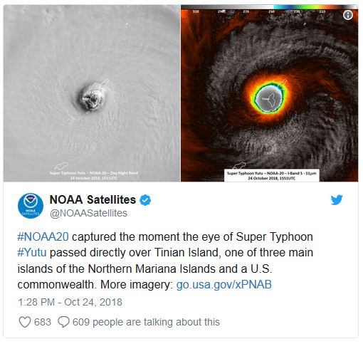
Figure: NOAA-20 image of Super Typhoon YuTu on 24 October 2018 at 1551UTC. Credit: William Straka III, CIMSS, NOAA.
ITEMS FOR THE ADMINISTRATOR:
ITEMS FOR THE ASSISTANT ADMINISTRATOR:
ITEMS FOR THE OFFICE DIRECTOR, STAR:
CIMSS Covers the Landfall of Super Typhoon Yutu on Tinian and Saipan: The Cooperative Institute for Meteorological Satellite Studies (CIMSS) Satellite Blog showed Himawari-8 infrared imagery (courtesy of the Japanese Meteorological Agency (JMA)) of the development (http://cimss.ssec.wisc.edu/goes/blog/archives/30398) and landfall (http://cimss.ssec.wisc.edu/goes/blog/archives/30407) of Super Typhoon Yutu on Tinian and Saipan, United States territories in the western Pacific. The blog posts also included microwave imagery from the Direct Broadcast (DB) antenna at the National Weather Service office on Guam. That antenna was installed with NOAA funds and is operated by CIMSS. NWS meteorologists in Guam relied on imagery created from software developed at the Space Science and Engineering Center (SSEC) to monitor its progress. Imagery and products are created in real-time with the SSEC Community Satellite Processing Package (CSPP) and ‘Polar2Grid’ software. Another SSEC software package, ‘AXI’ tools, is used to convert Himawari imagery into tiles that are ingested into the Advanced Weather Interactive Processing System (AWIPS). The staff at the NWS Guam office has been highly complimentary of SSEC’s role in providing meteorological training and support for their technical systems. Many SSEC scientists and developers have been part of the multi-year effort. (S. Bachmeier, CIMSS; S. Lindstrom, CIMSS, 608-263-4425; W. Straka III, CIMSS, 608-262-5128; K. Strabala, CIMSS, 608-263-8752; J. Gerth, CIMSS, 608-263-4942)
 (Click image to enlarge)
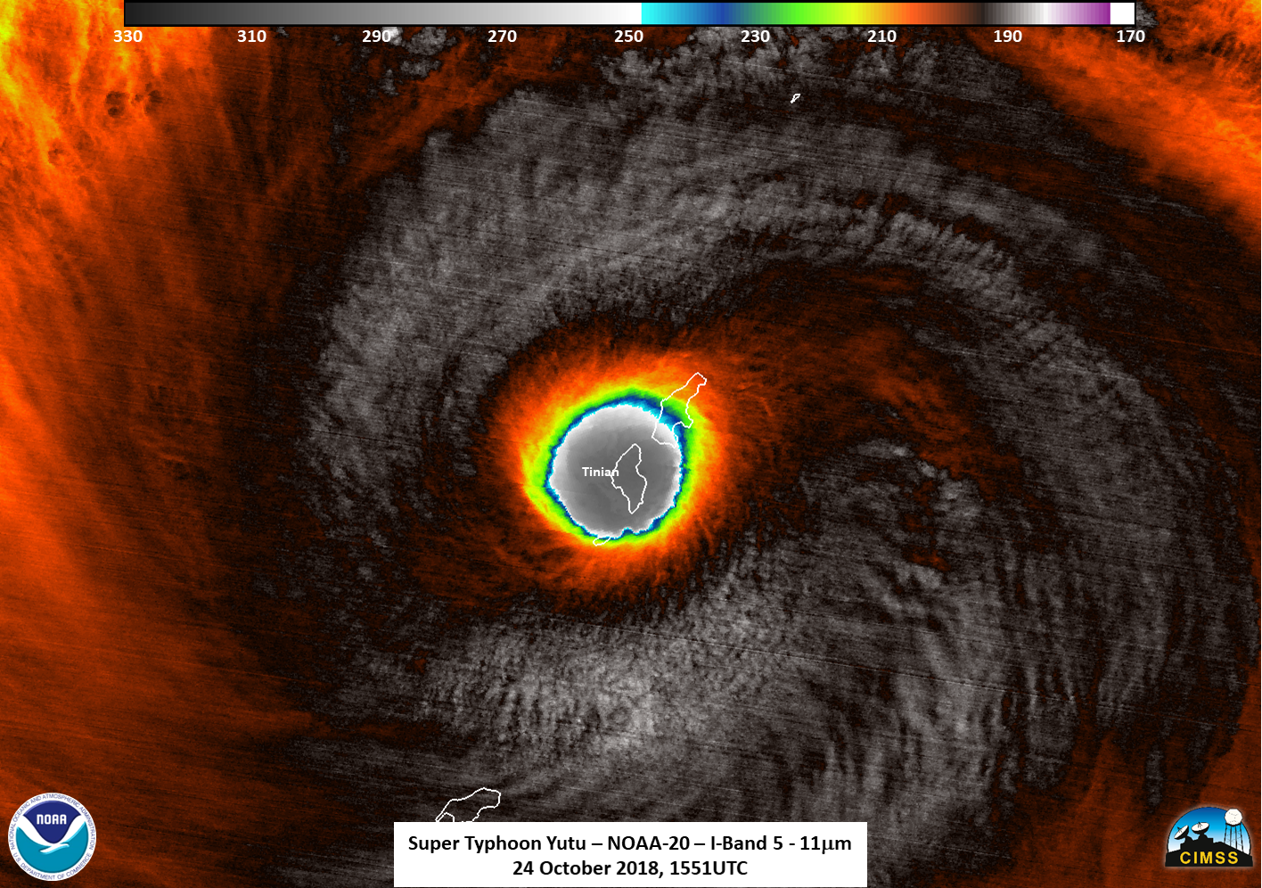
Figure: NOAA-20 Visible-Infrared Imaging Radiometer Suite (VIIRS) Band I05 (11.45 micrometers) imagery at 1551 UTC on 24 October; the island of Tinian is entirely within the eye of the Yutu.
Satellite Visualization Software Released: Following a three-year development effort, the Space Science and Engineering Center (SSEC) released the first full version (1.0.0) of the Satellite Information Familiarization Tool (SIFT). SIFT is multi-platform software built on Python with a graphical user interface for displaying, animating, and interrogating geostationary satellite imagery. The primary developers of SIFT are Ray Garcia and Dave Hoese. The National Weather Service (NWS) funded the development of SIFT starting in 2015. Interest in SIFT continues to grow with international users to support operational, science, and training activities. SIFT is open source, with versions for Windows, Mac, and Linux and sample data available for download at http://sift.ssec.wisc.edu/. (J. Gerth, CIMSS, 608-263-4942)
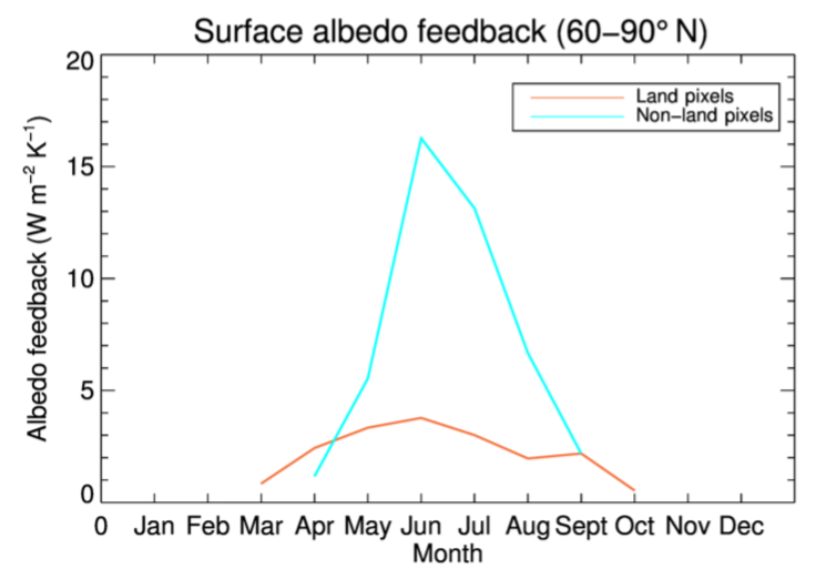
Paper on Changes in Arctic Sea Ice Outweigh Changes in Snow Cover: A paper titled "Arctic climate: changes in sea ice extent outweigh changes in snow cover", by A. Letterly, J. Key, and Y. Liu, was published in The Cryosphere (https://doi.org/10.5194/tc-12-3373-2018). Using a 34-year satellite-based climate data record, the authors show that the positive trend in solar absorption over the Arctic Ocean is more than double that over Arctic land, and the magnitude of the ice–albedo feedback is four times that of the snow–albedo feedback in summer. Therefore, decreasing sea ice cover, not changes in terrestrial snow cover, has been the dominant radiative feedback mechanism over the last few decades. (J. Key, E/RA2, 608-263-2605, jeff.key@noaa.gov; A. Letterly, CIMSS, 608-890-1981; Y. Liu, CIMSS, 608-265-8620)
 (Click image to enlarge)
Figure: The snow–albedo and ice–albedo feedbacks for Arctic land (orange) and ocean (cyan) for the period 1982–2015.
ITEMS FOR THE DIVISION CHIEF, CoRP:
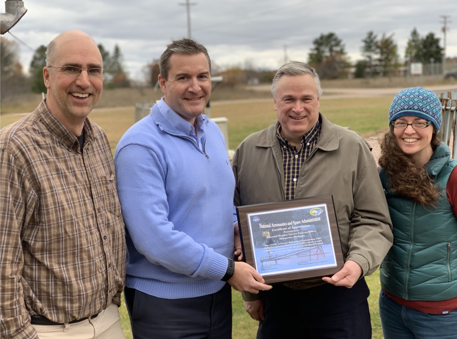
NWS Marquette Receives GPM Certificate of Appreciation: The National Weather Service (NWS) Marquette, Michigan office staff members were awarded a “Certificate of Appreciation” from the National Aeronautics and Space Administration (NASA) Global Precipitation Measurement (GPM) mission leadership. The NWS Marquette office is collaborating with NASA, the University of Wisconsin – Madison (UW), and Michigan Technological University (MTU) by hosting, deploying, and maintaining a suite of instruments that measure precipitation, with specific focus on snowfall. This work is supporting efforts to better estimate snow accumulation from satellite-based sensors. As well as to help illuminate relationships between snowflake microphysical properties and different types of snow events. GPM Science Team Members and project collaborators, Dr. Mark Kulie and Dr. Claire Pettersen, recently presented this “Certificate of Appreciation” to NWS MQT on behalf of NASA. The Director of the NWS, Dr. Louis Uccellini, also joined the award presentation remotely to congratulate the NWS Marquette, Michigan office staff. (Claire Pettersen, SSEC, 608-772-6270; Mark Kulie, SSEC)
 (Click image to enlarge)
Figure: Pictured above (L to R): Dr. Mark Kulie (Research Associate Professor, MTU), David Beachler (Science and Operations Officer), Robin Turner (Meteorologist in Charge), and Dr. Claire Pettersen (Associate Instrumentation Innovator, UW)
CIMSS Scientist Presents at Severe Local Storms Conference:Cooperative Institute for Meteorological Satellite Studies (CIMSS) scientist Leigh Orf presented the talk "The Role of the Streamwise Vorticity Current in Tornado Genesis and Maintenance" at the 29th Conference on Severe Local Storms in Stowe, VT on October 22, 2018. Link: https://youtu.be/yMHsip9DAUY. (L. Orf, CIMSS, 608-890-1983)
NOAA/NASA FIREX-AQ Science Team Meeting: Brad Pierce attended the joint NASA NOAA Fire Influence on Regional to Global Environments and Air Quality (FIREX-AQ (https://www.esrl.noaa.gov/csd/projects/firex-aq/) Science Team Meeting in Boulder, CO and presented an overview of satellite support and science objectives during the FIREX-AQ field campaign. FIREX-AQ will occur during the summer of 2019 and include a western phase, which will focus on western wild fires, and an eastern phase, which will focus on agricultural fires in the south eastern US. (R.B. Pierce, SSEC, 608-890-1892, brad.pierce@ssec.wisc.edu.
VISITORS:
NEXT WEEK:
LOOKING AHEAD:
| Archived Weeklies Page | Submit a report item |