[ Archive ]
| CIMSS-NOAA Weekly Report [ Archive ] |
ASPB AND CIMSS WEEKLY HIGHLIGHTS FOR THE WEEK ENDING NOVEMBER 23, 2018
IN THE PRESS:
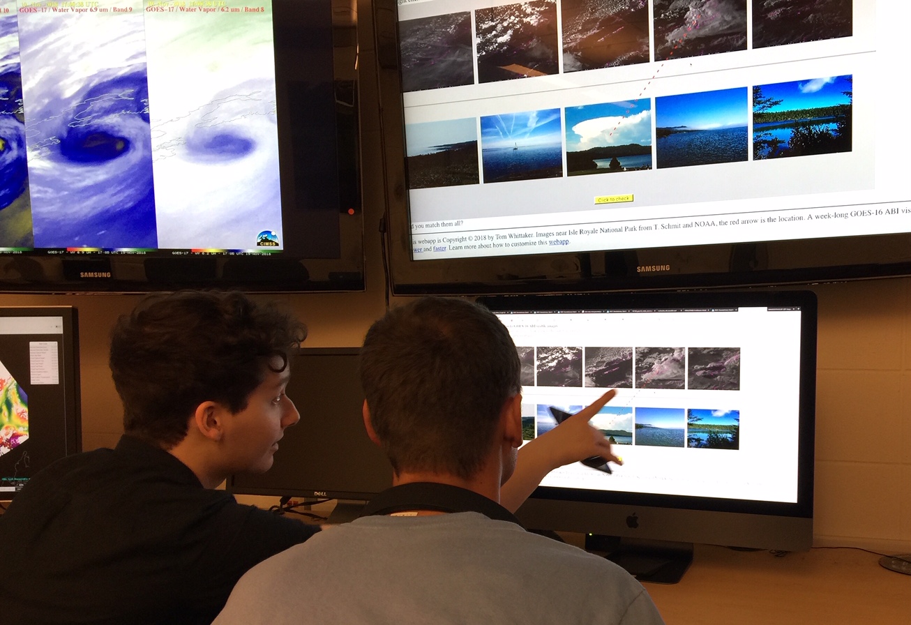
Interviews for a Video on GOES-R: Harry Dove-Robinson and Terrence Cook visited the Space Science and Engineering Center (SSEC) on November 20 and 21, 2018. Harry is an undergraduate student at Drexel University. The two of them produce videos about meteorology and are making a new piece on Geostationary Operational Environmental Satellite system (GOES)-R. Tim Schmit (NOAA) and Jerrold Robaidek, Scott Lindstrom and Chris Schmidt (SSEC) were interviewed. (T. Schmit, E/RA2, 608-263-0291)
 (Click image to enlarge)
Figure: Harry Dove-Robinson and Terrence Cook matching satellite imagery with ground-based photos.
ITEMS FOR THE ADMINISTRATOR:
ITEMS FOR THE ASSISTANT ADMINISTRATOR:
ITEMS FOR THE OFFICE DIRECTOR, STAR:
Paper on GIIRS published: A manuscript titled "Enhancing the fast radiative transfer model for FengYun-4 GIIRS by using local training profiles" has been published in JGR-Atmospheres ((DOI: 10.1029/2018JD029089, https://agupubs.onlinelibrary.wiley.com/doi/epdf/10.1029/2018JD029089). Coauthors are Di Di (CMA), Jun Li (CIMSS), Wei Han, Wenguang Bai, Chunqiang Wu (CMA), and W. Paul Menzel (CIMSS). (Jun Li, CIMSS, 608-262-3755, Jun.Li@ssec.wisc.edu)
Meeting on Proposed Changes to International Airways Volcano Watch: The World Meteorological Organization (WMO) Volcanic Ash Science Advisory Group (VASAG) met 5–9 November 2018 to evaluate the scientific merits of proposed changes to the International Airways Volcano Watch (IAVW). The IAVW is the International Civil Aviation Organization (ICAO) framework for aviation operations in airspace impacted by volcanic activity. Mike Pavolonis (NOAA/NESDIS/STAR) is a member of the VASAG and attended the meeting, which was hosted by the Civil Aviation Authority of New Zealand in Wellington. If the proposed changes to the IAVW, which are strongly supported by aviation stakeholders, are enacted, Volcanic Ash Advisories (VAAs) issued by Volcanic Ash Advisory Centers (VAACs) will be required to include quantitative information on ash concentration and the associated uncertainty, which is a major change. The proposed changes are primarily driven by advancements in satellite remote sensing (with NOAA playing a leading role) and engine testing. The WMO VASAG concluded that operational satellite remote sensing and dispersion modeling capabilities must continue to evolve over the next several years in order to support the proposed changes to the IAVW. The evolution of the IAVW is relevant to NOAA, as NOAA is a significant contributor to the IAVW. Continued investment in improving operational satellite remote sensing and dispersion modeling capabilities in NOAA is critical for meeting future IAVW requirements. (M. Pavolonis, E/RA2, 608-263-9597, Mike.Pavolonis@noaa.gov)
New Zealand Met Service Visit: Mike Pavolonis (NOAA/NESDIS/STAR) visited the New Zealand Met Service in Wellington, New Zealand from November 12-16, 2018. The Met Service, which operates a Volcanic Ash Advisory Center (VAAC), routinely utilizes satellite-based volcanic cloud products from the VOLcanic Cloud Analysis Toolkit (VOLCAT) developed by NOAA/NESDIS/STAR. Pavolonis met with VAAC forecasters and gave a training seminar on VOLCAT. The Met Service expressed their appreciation for the VOLCAT products, which have enhanced their operational capabilities. In addition, a mutually beneficial collaboration on integrating VOLCAT products with dispersion models was advanced during the visit. A new tool that automatically initiates a dispersion model forecast, when VOLCAT generates a volcanic eruption alert, was developed. (M. Pavolonis, E/RA2, 608-263-9597, Mike.Pavolonis@noaa.gov)
ITEMS FOR THE DIVISION CHIEF, CoRP:
CIMSS Comparing GOES-16 to GOES-17 and FPM Temperatures: Plots of the GOES-17 Longwave Infrared (LWIR) Focal Plane Module (FPM)temperatures and comparing GOES-16 to GOES-17 imagery are being generated at the Cooperative Institute for Meteorological Satellite Studies (CIMSS) and are being shared on the web. This information is meant to help users understand the impacts of the GOES-17 cooling issue on data and image quality. The plots, which include GOES-16 and GOES-17 means for a central comparison area, as well a GOES-17 minus GOES-16 difference, are also being used to determine when different bands drop out, and return, due to the increased operating temperature of GOES-17. This page is not intended to be an operational tool and plots are generated hourly, since engineering telemetry data containing FPM temperatures are received once per hour, generally with a 3 hour lag (http://cimss.ssec.wisc.edu/goes-r/abi-/band_statistics_imagery.html). (M. Gunshor, CIMSS, 608-263-1146, J. Nelson, CIMSS, T. Schmit, E/RA2, 608-263-0291, tim.j.schmit@noaa.gov)
CIMSS Forecast Support for the NCAA D1 Cross Country Championship in Madison: Scott Lindstrom, Cooperative Institute for Meteorological Satellite Studies (CIMSS), provided forecast and weather nowcast decision support for the National Collegiate Athletic Association (NCAA) D1 Cross Country Championships that were held at the Thomas Zimmer Championship Course in Madison on Saturday 17 November. Women's 6K and Men's 10K races occurred on top of an inch or so of fresh snow. (Scott Lindstrom, CIMSS, 608 263 4425)
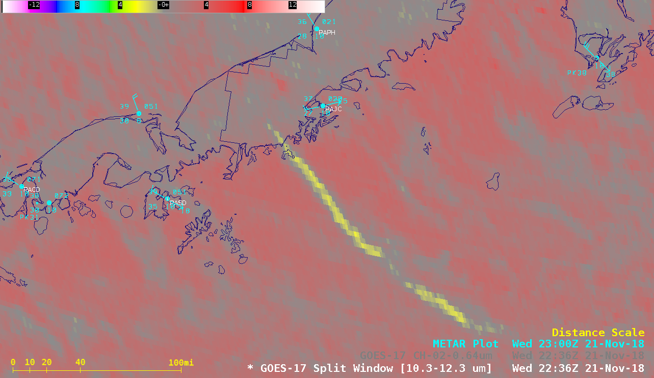
GOES-17 imagery over Alaska and Hawaii: The Cooperative Institute for Meteorological Satellite Studies (CIMSS) Satellite Blog was updated with posts containing Geostationary Operational Environmental Satellite (GOES)-17 imagery. On November 21, 2018 the Anchorage, Alaska National Weather Service forecast office requested a Mesoscale Domain Sector to provide 1-minute images for monitoring an ongoing volcanic eruption of Mount Veniaminof (http://cimss.ssec.wisc.edu/goes/blog/archives/30775). On the same day, GOES-17 Water Vapor images of Hawaii revealed interesting thermal signatures of the island terrain (http://cimss.ssec.wisc.edu/goes/blog/archives/30784). GOES-17 data remains preliminary and non-operational until it takes over duties as the GOES-West satellite in December 2018. (S. Bachmeier, CIMSS, 608-263-5974)
 (Click image to enlarge)
Figure: GOES-17 Split Window Difference (10.3-12.3 µm) image at 22:36 UTC, showing the volcanic ash plume from Mount Veniaminof drifting southeastward over the Gulf of Alaska.
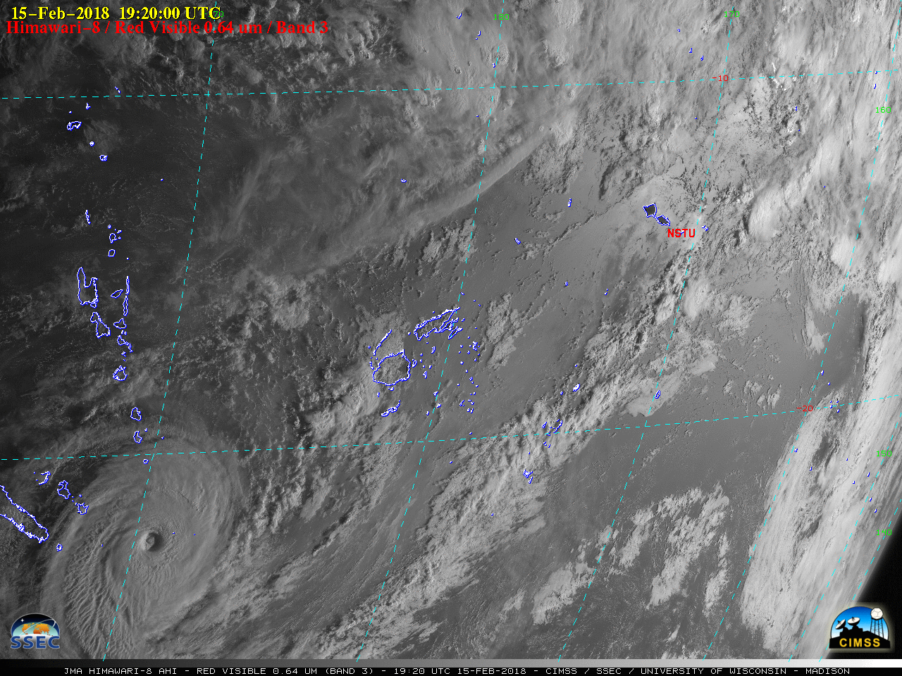
Himawari images of Cyclone Gita in the South Pacific Ocean: At the request of the National Weather Service (NWS) Pacific Region Headquarters, animations of Himawari-8 and Himawari-9 visible and infrared imagery of Cyclone Gita in the South Pacific Ocean (during the period February 3-15, 2018) were prepared for use in a Regional Service Assessment for the NWS office in American Samoa. Himawari-8/9 images were processed using data from the Space Science and Engineering Center (SSEC) Data Center archive. (S. Bachmeier, CIMSS, Jordan Gerth, CIMSS)
 (Click image to enlarge)
Figure: Himawari-8 Visible image of Cyclone Gita on February 15, 2018.

VISITORS:
NEXT WEEK:
LOOKING AHEAD:
| Archived Weeklies Page | Submit a report item |