[ Archive ]
| CIMSS-NOAA Weekly Report [ Archive ] |
ASPB AND CIMSS WEEKLY HIGHLIGHTS FOR THE WEEK ENDING FEBRUARY 15, 2019
IN THE PRESS:
ITEMS FOR THE ADMINISTRATOR:
ITEMS FOR THE ASSISTANT ADMINISTRATOR:
ITEMS FOR THE OFFICE DIRECTOR, STAR:
New Paper Published in Nature Communications: The paper "Recent increases in tropical cyclone intensification rates" by Kieran T. Bhatia, Gabriel A. Vecchi, Thomas R. Knutson, Hiroyuki Murakami, Keith W. Dixon and Carolyn E. Whitlock (GFDL), and James Kossin (NCEI) was published on in Nature Communications on 7 February 2019 (https://www.nature.com/articles/s41467-019-08471-z) and has been discussed in the Washington Post (https://wapo.st/2X1DbPc), CBS News (https://cbsn.ws/2X1DHwC), and the Miami Herald (https://hrld.us/2X2ujJ3). (J. Kossin, NCEI, 608-265-5356)
Manuscript Published in Weather and Forecasting: A manuscript entitled "Tropical Cyclone Forecasts Impact Assessment from the Assimilation of Hourly Visible, Shortwave, and Clear-Air Water Vapor Atmospheric Motion Vectors in HWRF" authored by Agnes H.N. Lim (CIMSS), James A. Jung (CIMSS), Sharon E. Nebuda (CIMSS), Jaime M. Daniels (NESDIS), Wayne Bresky (NESDIS), Mingjing Tong (EMC), and Vijay Tallapragada (EMC) was published in Weather and Forecasting. The manuscript documented the use of hourly shortwave infrared, clear air water vapor and visible atmospheric motion vectors (AMVs) derived from GOES-13 in HWRF and their forecast impacts. (A. Lim, CIMSS, 608-263-6720)
Manuscript on local severe storm tracking and warning in pre-convection stage using advanced geostationary imager data published: A manuscript titled "Local Severe Storm Tracking and Warning in Pre-Convection Stage from the New Generation Geostationary Weather Satellite Measurements" has been published in Remote Sensing (2019, 11(4), 383; doi:10.3390/rs11040383, https://www.mdpi.com/2072-4292/11/4/383/pdf). Co-authors are Zijing Liu (CMA), Min Min (CMA), Jun Li (CIMSS), Zhenglong Li (CIMSS) et al. (Jun Li, CIMSS, Jun.Li@ssec.wisc.edu, 608-262-3755)
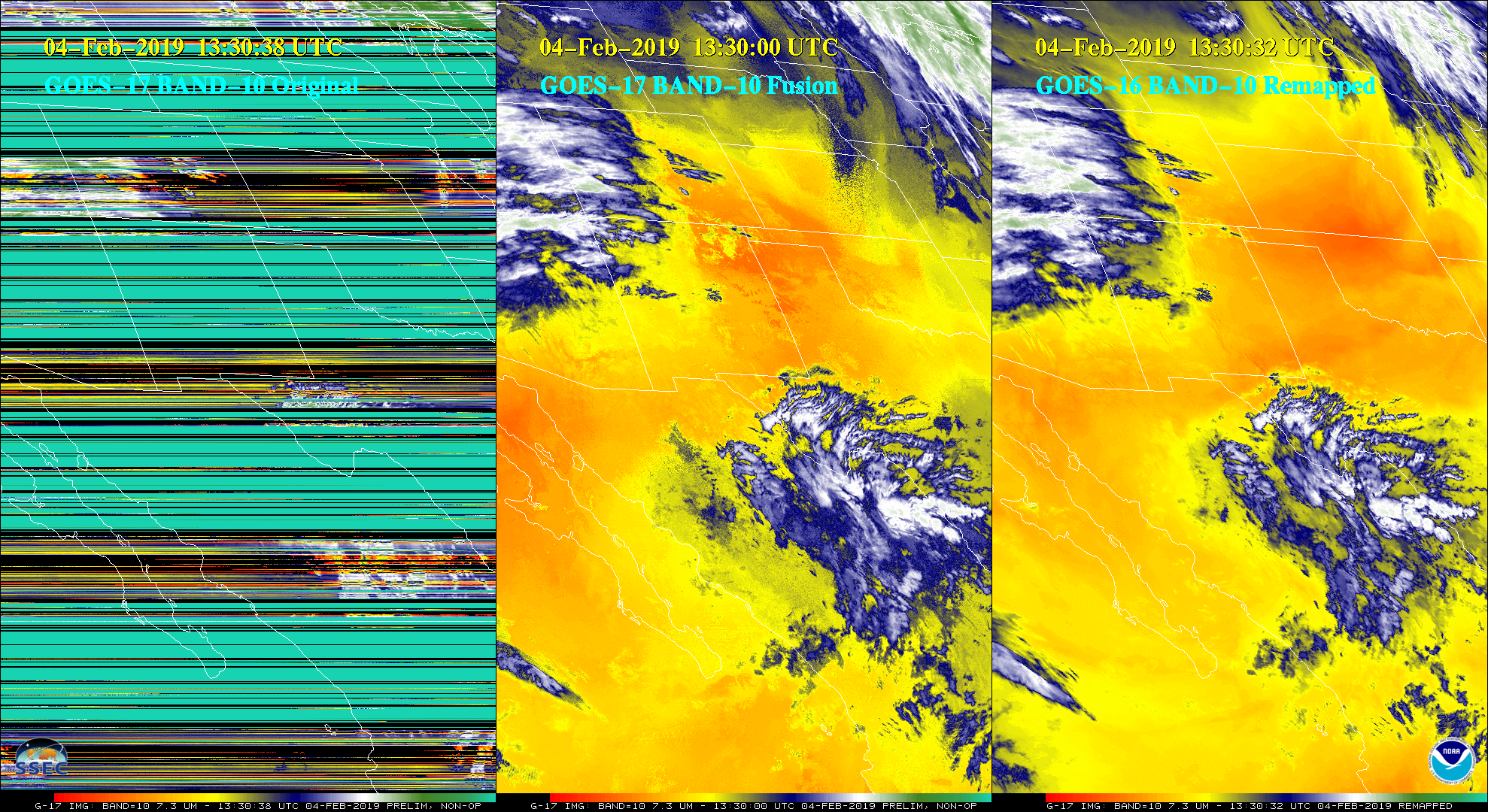
GOES-17 Fusion Imagery Available Online: Scientists at the University of Wisconsin-Madison Space Science and Engineering Center (SSEC) and Cooperative Institute for Meteorological Satellite Studies (CIMSS) have developed a data fusion product to mitigate the impacts of the nocturnal Loop Heat Pipe (LHP) issue on the Geostationary Operational Environmental Satellite (GOES)-17 Advanced Baseline Imager (ABI) qualitative imagery. Data Fusion uses relationships in the infrared (IR) bands during stable instrument temperature times to generate experimental imagery for affected IR bands when the LHP issue makes the operational imagery unusable. Thus users of Data Fusion imagery will be able to maintain imagery continuity when LHP issues occur. The Fusion Product is still experimental and CIMSS appreciates feedback on its viability for various uses. Fusion imagery is being generated and put on the SSEC Geostationary Satellite Imagery web site in near-real-time at https://www.ssec.wisc.edu/data/geo/#/animation?satellite=goes-17-fusion. More information can be found on the CIMSS Satellite Blog at http://cimss.ssec.wisc.edu/goes/blog/archives/31740. (M. Gunshor, CIMSS, matg@ssec.wisc.edu, E. Weisz, CIMSS, W.P. Menzel, CIMSS, R. Kohrs, SSEC, J. Nelson, CIMSS, S. Lindstrom, CIMSS, T. Schmit, E/RA2, 608-263-0291, tim.j.schmit@noaa.gov)
 (Click image to enlarge)
Figure: GOES-17 original ABI band 10 (lower-level water vapor), GOES-17 Fusion, and GOES-16 (remapped) imagery for 04 February 2019 at 13:30 UTC.
ITEMS FOR THE DIVISION CHIEF, CoRP:
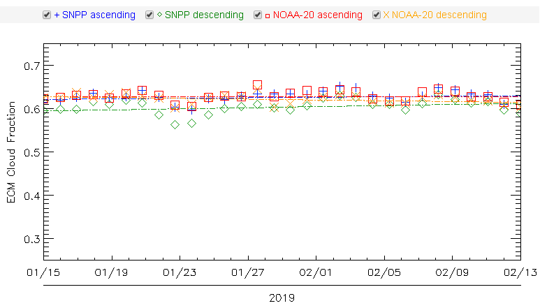
New VIIRS Cloud Product Evaluation Web Page: The cloud product NOAA Algorithm Working Group (AWG) at the Cooperative Institute for Meteorological Satellite Studies (CIMSS) has developed a new web page to monitor Visible Infrared Imaging Radiometer Suite (VIIRS) cloud products (http://cimss.ssec.wisc.edu/clavrx/viirs_img/). The page was designed to help more quickly identify strengths and weaknesses in cloud products. To help identify outlier conditions, the page includes tools to monitor weekly, monthly, and seasonal trends in cloud products. The website also includes visualization tools to display static imagery or animations of recent cloud products. (J. Hoffman, CIMSS, 608-890-1690, A. Heidinger, E/RA2, 608-263-6757, andrew.heidinger@noaa.gov))
 (Click image to enlarge)
Figure: Daily cloud fraction Enterprise Cloud Mask from VIIRS on SNPP and NOAA-20 (ascending and descending orbits) over the past month.
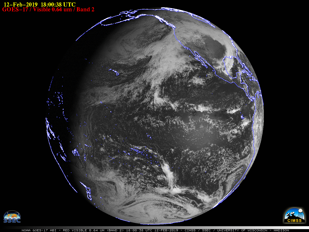
CIMSS Satellite Blog Updates: The Cooperative Institute for Meteorological Satellite Studies (CIMSS) Satellite Blog (http://cimss.ssec.wisc.edu/goes/blog/) was updated with the posts "Moisture Streaming towards Southern California" (February 14), "Dry air over Florida" (February 14), "Data Fusion to mitigate Loop Heat Pipe data dropouts with GOES-17" (February 13), "Seattle, Washington as viewed by 4 GOES" (February 13), "Turbulence over the western United States" (February 13), "GOES-17 becomes the operational GOES-West satellite" (February 12), and "Strong midlatitude cyclone north of Hawai’i" (February 10). (S. Bachmeier, CIMSS, 608-263-3958, S. Lindstrom, CIMSS, 608-263-4425)
 (Click image to enlarge)
Figure: GOES-17 Full Disk "Red" Visible (0.64 µm) image at 1800 UTC on February 12, 2019 when GOES-17 was declared the operational GOES-West satellite.
VISITORS:
NEXT WEEK:
LOOKING AHEAD:
| Archived Weeklies Page | Submit a report item |