[ Archive ]
| CIMSS-NOAA Weekly Report [ Archive ] |
ASPB AND CIMSS WEEKLY HIGHLIGHTS FOR THE WEEK ENDING MARCH 8, 2019
IN THE PRESS:
SSEC and CIMSS Scientists in the News: Scientists at the University of Wisconsin-Madison (UW) Space Science and Engineering Center (SSEC) and the Cooperative Institute for Meteorological Satellite Studies (CIMSS) provide expert commentary, interviews, and imagery to news media and participate in events to promote science. In the news this week: 1) SSEC and CIMSS are encouraging high school seniors with demonstrated achievement in the physical sciences to apply for the Verner E. Suomi Scholarship by March 14. More information is at https://www.ssec.wisc.edu/news/articles/11716/. 2) CIMSS Satellite Blog contributors Scott Bachmeier and Scott Lindstrom published posts on "Standing wave clouds over Virginia and North Carolina" (Mar. 7), "NUCAPS soundings and GOES-16 derived stability index lifted index comparison" (Mar. 6), "Tehuano wind event" (Mar. 5-6), "The Default location of GOES-17 Mesoscale Sector #2 has moved" (Mar. 5), "Tornado outbreak in Alabama and Georgia" (Mar. 3), "Cold temperatures in Montana" (Mar. 3). Read more at the CIMSS Satellite Blog (http://cimss.ssec.wisc.edu/goes/blog/). (S. Bachmeier, CIMSS, S. Lindstrom, SSEC, J. Phillips, SSEC)
 (Click image to enlarge)
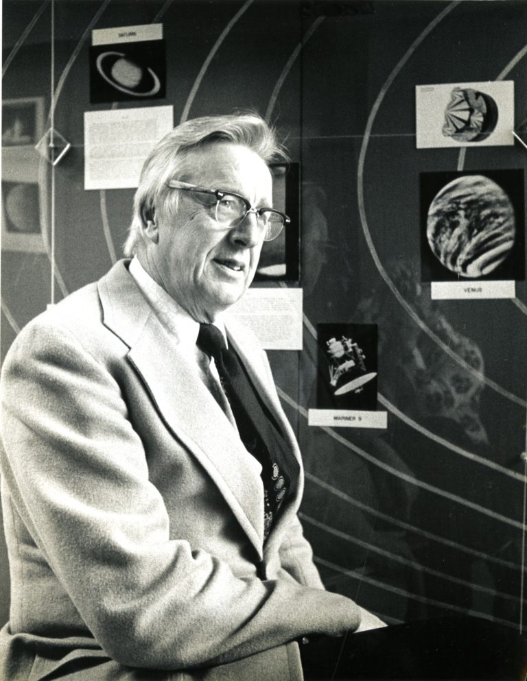
Figure: Professor Verner E. Suomi. Credit: UW-Madison Archives.
 (Click image to enlarge)
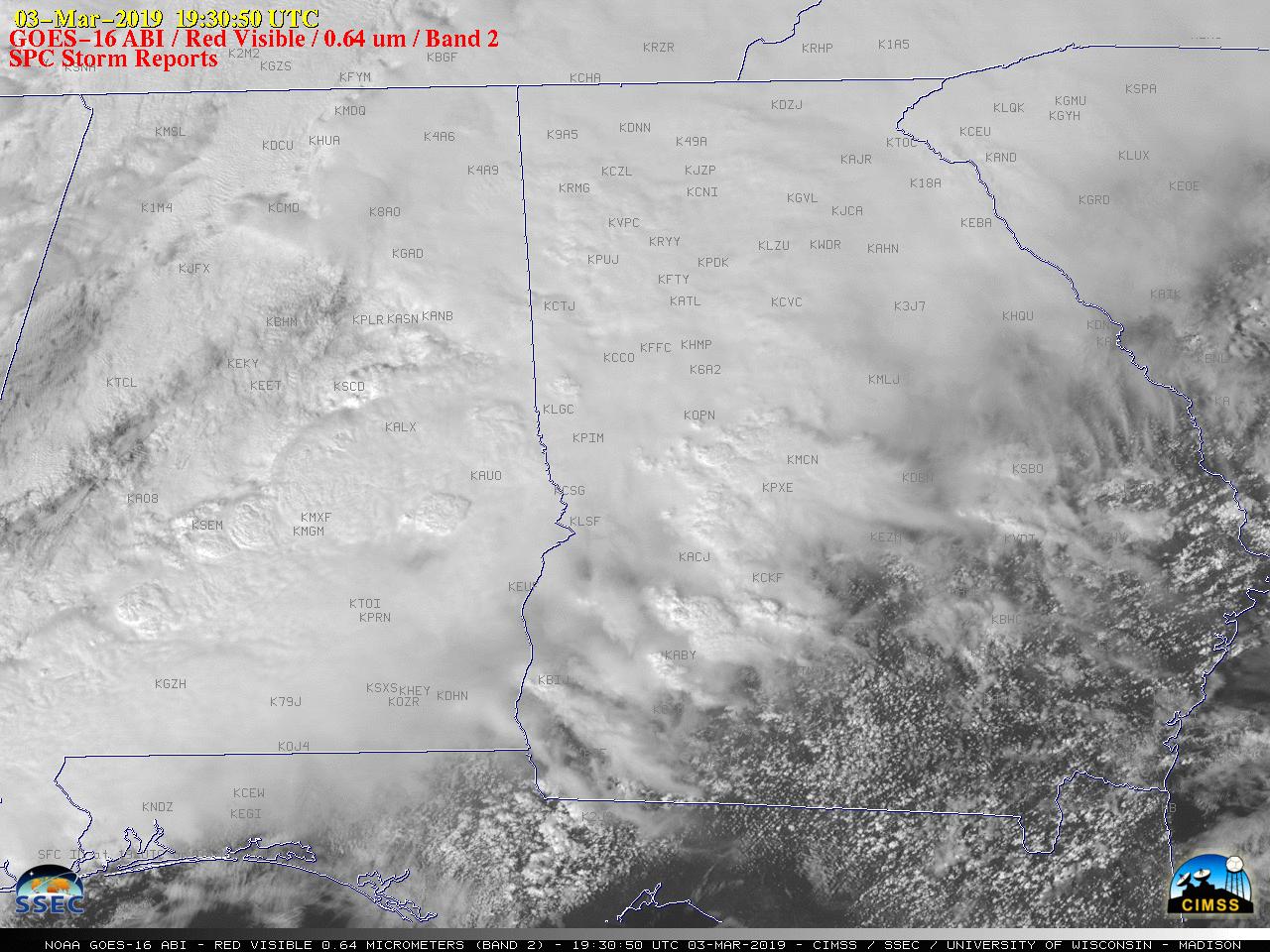
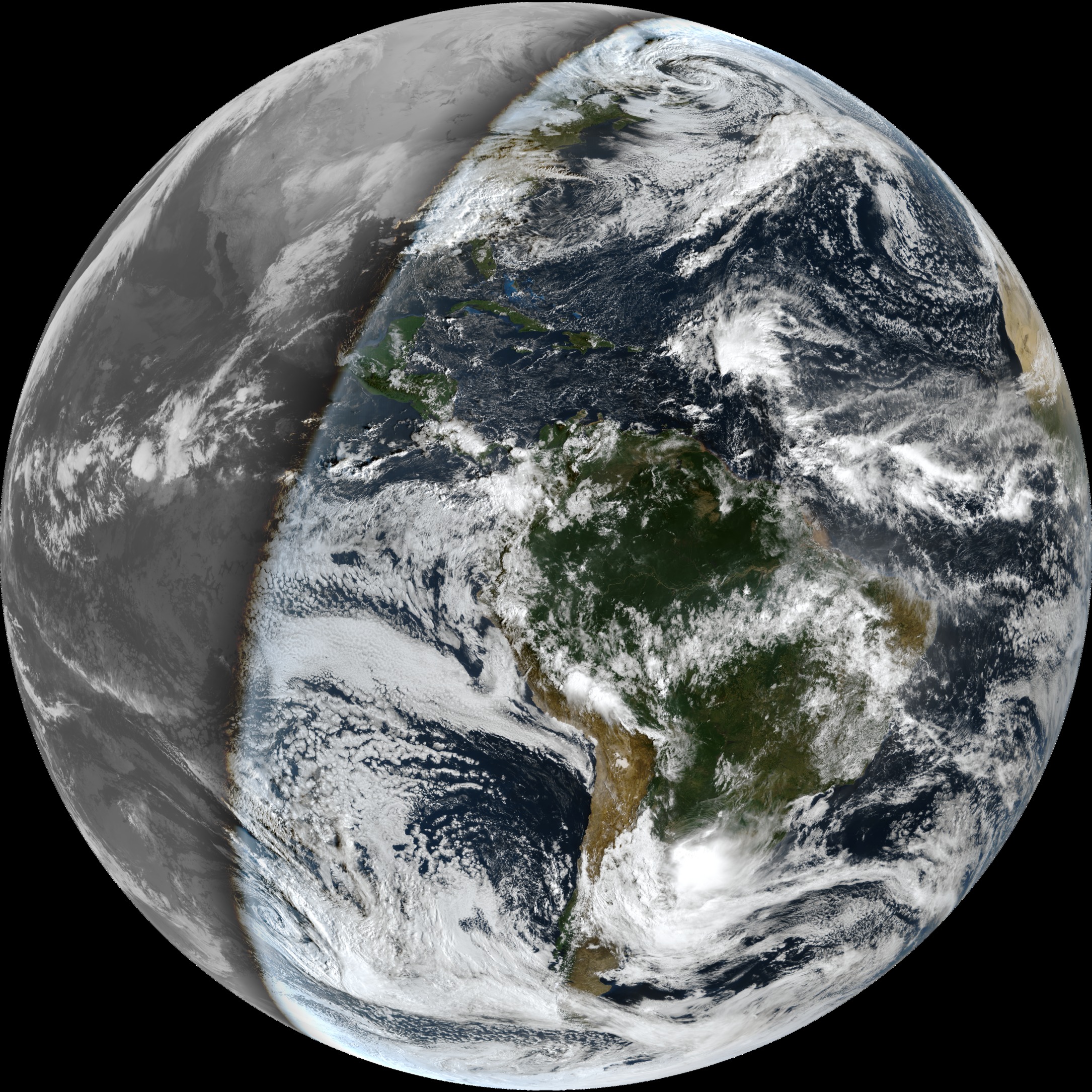
Figure: An outbreak of severe thunderstorms in Alabama and Georgia on 03 March 2019, produced large hail, damaging winds and tornadoes according to SPC storm reports. 1-minute Mesoscale Domain Sector GOES-16 (GOES-East) “Red” Visible (0.64 µm) images showed the development of numerous thunderstorms along and ahead of an advancing cold front. Credit: CIMSS.
ITEMS FOR THE ADMINISTRATOR:
ITEMS FOR THE ASSISTANT ADMINISTRATOR:
ITEMS FOR THE OFFICE DIRECTOR, STAR:
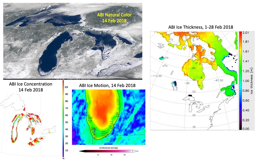
GOES-R Cryosphere Products Algorithm Readiness Review: The GOES-R NOAT Cryosphere Products Algorithm Readiness Review (ARR) was held March 3, 2019. Participants from STAR presented the risks and actions, requirements, software architecture, and the algorithm package for three Advanced Baseline Imager (ABI) products: ice concentration, ice thickness and age, and ice motion. The algorithm developers from the Cooperative Institute for Meteorological Satellite Studies (CIMSS) and STAR presented validation results for those products. The results were positive, with all products meeting accuracy requirements. (J. Key, E/RA2, 608-263-2605, jeff.key@noaa.gov)
 (Click image to enlarge)
Figure: ABI natural color image on 14 February 2018 (top left) of the Great Lakes, ABI ice concentration and motion for the same day (bottom left and right), and ABI ice thickness over Hudson Bay and Baffin Bay averaged over the entire month (right).
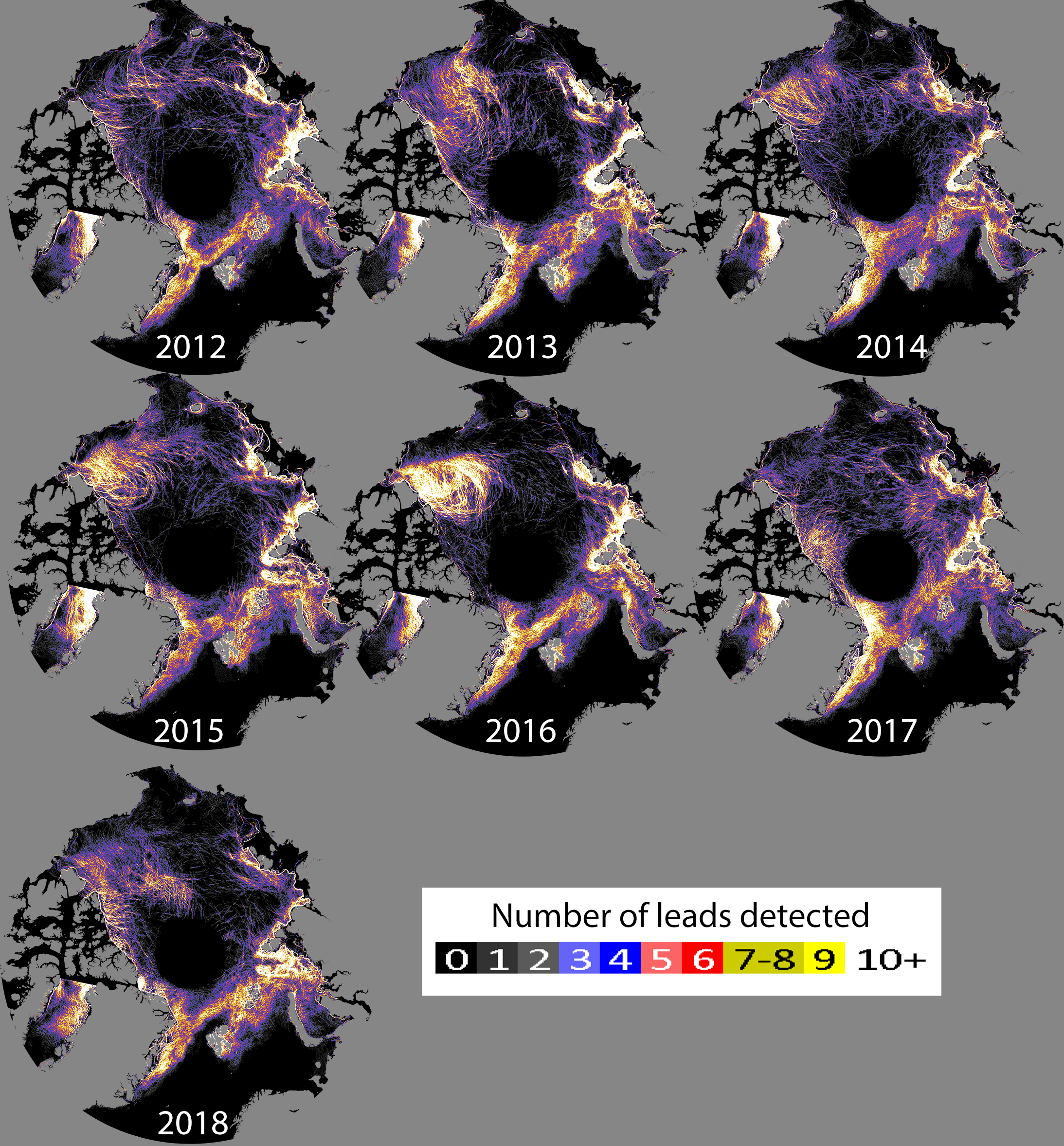
Manuscript on Sea Ice Leads Published: A manuscript entitled "The Detection and Characterization of Arctic Sea Ice Leads with Satellite Imagers", has been published in Remote Sensing (2019, 11(5), 521; https://doi.org/10.3390/rs11050521). Authors are Jay Hoffman (CIMSS), Steve Ackerman (CIMSS), Yinghui Liu (ASPB), and Jeff Key (ASPB). More information on the project is available at https://www.ssec.wisc.edu/leads. (J. Hoffman, CIMSS 608-890-1690)
 (Click image to enlarge)
Figure: Lead frequency map by year 2012-2018. Color coded legend represents number of days with a lead detected between January through April.
Geo2Grid Image Creation Software Package Released: The Community Satellite Processing Package (CSPP) for Geostationary Satellites (Geo) group at the University of Wisconsin-Madison released a software package that provides the capability to create high quality single band and combined Red/Green/Blue (RGB) image files in an easy and efficient manner from geostationary imager data files. The software supports the Geostationary Operational Environmental Satellite (GOES)-16 and GOES-17 Advanced Baseline Imager (ABI) and the Himawari-8 Advanced Himawari Imager (AHI). Creation of the images is carried out by simple bash shell script commands, which wrap underlying Python code. The software features sharpening, and Rayleigh correction as part of the true color image creation, allows latitude/longitude subsetting, and supports combining different bands/RGBs into day/night images. The release also includes utility scripts to overlay borders, coastlines and grids on the image files and to create animations from the output files. (G. Martin, CIMSS, 608-263-6794, D. Hoese, SSEC, K. Strabala, CIMSS)
 (Click image to enlarge)
Figure: Geo2Grid image of combined GOES-16 ABI true color (daytime) and Channel 14 brightness temperatures (nighttime) using observations from 12 November 2018, 12:30 UTC.
ITEMS FOR THE DIVISION CHIEF, CoRP:
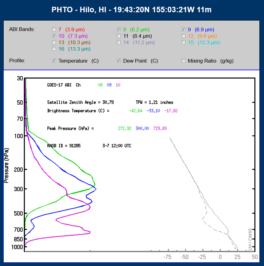
CIMSS Provides Realtime GOES-17 Weighting Functions: Researchers at the Cooperative Institute for Meteorological Satellite Studies (CIMSS) have updated the real-time web page displaying weighting functions for the Geostationary Operational Environmental Satellite (GOES) Imagers, now including GOES-17 (all infrared bands), along with GOES-15 and -16. The weighting functions are calculated using the Pressure-Layer Fast Algorithm for Atmospheric Transmittances fast forward model on atmospheric profiles derived from radiosondes at stations across the hemisphere. The interactive web page (http://cimss.ssec.wisc.edu/goes/wf) updates twice a day with 00 UTC and 12 UTC radiosonde data. These pages can be used to better understand water vapor imagery: https://twitter.com/CIMSS_Satellite/status/1101291157546516483 or https://cimss.ssec.wisc.edu/goes/blog/archives/31848. (M. Gunshor, CIMSS, 608-263-1146, S. Bachmeier, CIMSS, 608-263-3958, T. Schmit, E/RA2, 608-263-0291, tim.j.schmit@noaa.gov)
 (Click image to enlarge)
Figure: Sample GOES-17 clear-sky weighting functions for the ABI mid-level water vapor bands over Hawaii.
VISITORS:
NEXT WEEK:
LOOKING AHEAD:
| Archived Weeklies Page | Submit a report item |