[ Archive ]
| CIMSS-NOAA Weekly Report [ Archive ] |
ASPB AND CIMSS WEEKLY HIGHLIGHTS FOR THE WEEK ENDING MARCH 22, 2019
IN THE PRESS:
SSEC and CIMSS Scientists in the News: Scientists at the University of Wisconsin-Madison (UW) Space Science and Engineering Center (SSEC) and the Cooperative Institute for Meteorological Satellite Studies (CIMSS) provide expert commentary, interviews, and imagery to news media and participate in events to promote science. In the news this week: 1) CIMSS scientist Jordan Gerth was interviewed about the Federal Communications Commission's spectrum proposal that could potentially "harm the accuracy of weather models relied on by forecasters." Read more in SSEC in the News (https://go.wisc.edu/5ams8d). 2) CIMSS scientist Jason Otkin's drought research was featured in a story by NESDIS News (https://go.wisc.edu/25ff86). 3) CIMSS Satellite Blog contributor Scott Bachmeier published posts on "Tropical Cyclone Veronica north of Australia" (Mar. 21), "Record warmth in Alaska and Canada" (Mar. 19), "Chemical plant fire near Houston, Texas" (Mar. 18), "Signatures of fresh snowfall in the Dakotas" (Mar. 17), and "Gas explosion and fire in Los Angeles, California" (Mar. 16). Read more at the CIMSS Satellite Blog (http://cimss.ssec.wisc.edu/goes/blog/). (J. Gerth, CIMSS, J. Otkin, CIMSS, S. Bachmeier, CIMSS, J. Phillips, SSEC)
 (Click image to enlarge)
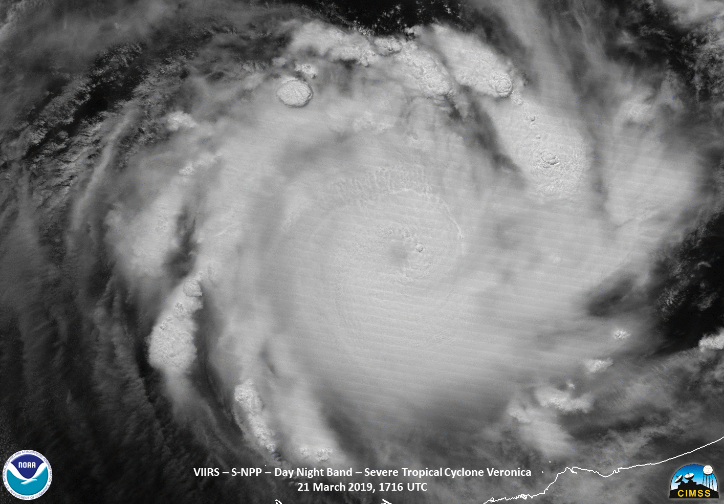
Figure: Suomi NPP VIIRS Day/Night Band (0.7 µm) and Infrared Window (11.45 µm) images showed Category 4 Cyclone Veronica off the northern coast of Western Australia at 1716 UTC on 21 March 2019. Credit: CIMSS.
 (Click image to enlarge)
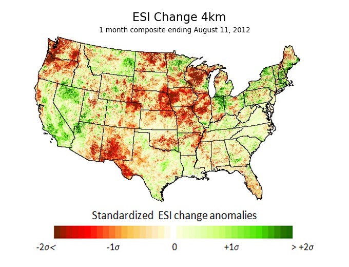
Figure: This image shows how the 1-month ESI changed over a 1-week period. These are "standardized" changes rather than actual raw changes in the ESI, and that allows you to more cleanly assess how unusual the changes are with respect to the local climatology. The red and brown colors across the Midwest show that conditions were deteriorating very rapidly compared to climatology. Credit:Jason Otkin, CIMSS.
ITEMS FOR THE ADMINISTRATOR:
ITEMS FOR THE ASSISTANT ADMINISTRATOR:
ITEMS FOR THE OFFICE DIRECTOR, STAR:
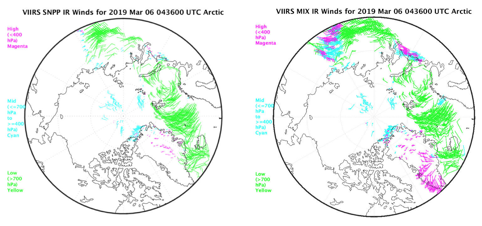
New Tandem VIIRS Winds Product: A new satellite-derived wind product has been developed at the Cooperative Institute for Meteorological Satellite Studies (CIMSS) that uses cloud tracking features from S-NPP and NOAA-20 together. With both satellites in the same orbit but separated by approximately 50 minutes, and both having VIIRS, we now have the capability of generating a “tandem” winds product. By using the CLAVR-x cloud properties (ACHA, A. Heidinger) and the cluster wind retrieval method developed for GOES-R and used operationally for the VIIRS single-satellite wind product, Cloud Motion Vectors (CMVs) are now being generated routinely every 50 minutes over the polar regions using the tandem S-NPP/NOAA-20 configuration. Figure 1 gives an example of the tandem and single-satellite winds from the infrared (IR) window channel over the Arctic, showing good agreement with the single-satellite winds. The single-satellite derived CMVs are available at a 100-minute time step; the tandem VIIRS winds have a 50-minute time step. In addition to being available faster, the tandem winds have greater spatial coverage because of the large overlap between the orbital swaths of the two satellites. The next steps are to quantitatively compare the tandem winds to single-satellite S-NPP, NOAA-20, and MODIS winds, and to validate the product with rawinsondes. Furthermore, with both satellites crossing the equator 14 times a day, global coverage of the tandem VIIRS winds product is possible. The plan is to extend this product into lower latitudes in the near future. (R. Dworak, CIMSS, 608-265-8620; D. Santek, CIMSS, 608-263-7410; S. Wanzong, CIMSS, 608-263-1950; Key, E/RA2, 608-263-2605, jeff.key@noaa.gov)
 (Click image to enlarge)
Figure: Plots of IR winds at the same date and time over the Arctic, 06 March 2019 at 0436 UTC, from S-NPP alone (left) and from the combination of S-NPP and NOAA-20 (right).
ITEMS FOR THE DIVISION CHIEF, CoRP:
Training at National Weather Service Offices in Alaska: During the week of 18 March 2019, Jordan Gerth and Scott Lindstrom, of the Cooperative Institute for Meteorological Satellite Studies (CIMSS), held conversations on applications for NOAA weather satellite imagery with small groups of operational meteorologists at National Weather Service (NWS) forecast offices in Anchorage, Alaska, and Juneau, Alaska, supplementing earlier online training. There were up to four conversations each day, with each group conversation lasting approximately three hours. During the conversations, live data from the Geostationary Operational Environmental Satellite R-Series (GOES-R) and Joint Polar Satellite System (JPSS) that had been integrated into the Advanced Weather Interactive Processing System (AWIPS) were discussed. The NWS Alaska Region covered the cost for the training sessions, which will continue next week in Anchorage, Alaska, and Fairbanks, Alaska, to reach as many staff members as possible. (J. Gerth, CIMSS, 608-263-4942, S. Lindstrom, CIMSS)
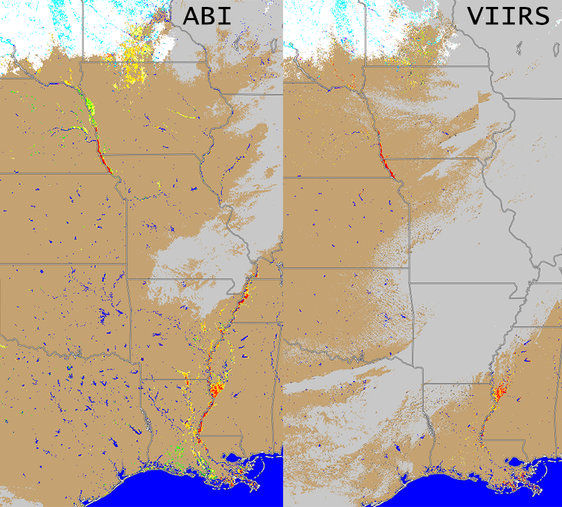
VIIRS and ABI Flood Product Coverage in the Midwest: Using Visible Infrared Imaging Radiometer Suite (VIIRS) and the Geostationary Operational Environmental Satellite (GOES)-16, the Cooperative Institute for Meteorological Satellite Studies (CIMSS) is running two flood detection products - developed by Sanmei Li and Donglian Sun at George Mason University (GMU). Both products have captured the flooding in the Midwest and are routinely produced at CIMSS using data from the CIMSS Direct Broadcast and GOES Rebroadcast (GRB) antennae. Each product has advantages: the GOES product uses clear-sky compositing to reduce the impact of cloud cover, while the VIIRS product has finer spatial resolution. The products are routinely distributed to the National Weather Service River Forecast Center (RFCs) offices via Advanced Weather Interactive Processing System (AWIPS2) as well as FTP to the Federal Emergency Management Agency (FEMA) and publicly available online via RealEarth (http://realearth.ssec.wisc.edu). Both the RFCs and FEMA are utilizing these critical products in their decision making as well as for situational awareness. Interactions with other state and Federal agencies are also beginning to take shape as this critical product becomes more widely know through coordination calls with state and Federal agencies during the ongoing floods in several states. (J. Hoffman, CIMSS, W. Straka III, CIMSS, S. Batzli, SSEC/ERSC)
 (Click image to enlarge)
Figure: Flood product example from 20 March 2019 showing flooding in the Midwest and Lower Mississippi regions from GOES-16 ABI (left) and SNPP/NOAA-20 VIIRS (right).
VISITORS:
NEXT WEEK:
LOOKING AHEAD:
| Archived Weeklies Page | Submit a report item |