[ Archive ]
| CIMSS-NOAA Weekly Report [ Archive ] |
ASPB AND CIMSS WEEKLY HIGHLIGHTS FOR THE WEEK ENDING APRIL 5, 2019
IN THE PRESS:
SSEC and CIMSS Scientists in the News: Scientists at the University of Wisconsin-Madison (UW) Space Science and Engineering Center (SSEC) and the Cooperative Institute for Meteorological Satellite Studies (CIMSS) provide expert commentary, interviews, and imagery to news media and participate in events to promote science. In the news this week: 1) CIMSS Director Tristan L'Ecuyer announced Nuo Chen as the first recipient of the William L. Smith, Sr. Graduate Scholarship. Chen will pursue a Ph.D. in the UW’s Department of Atmospheric and Oceanic Sciences and collaborate with CIMSS researchers to study tropical cyclone intensification and methods for improving their forecasts through data assimilation (https://www.ssec.wisc.edu/news/articles/11859/). 2) CIMSS Director Tristan L'Ecuyer talked with Forbes about the upcoming Polar Radiant Energy in the Far Infrared Experiment (PREFIRE). Data gathered from the Cubesat mission is expected to help improve climate models over the Arctic (https://go.wisc.edu/95zlle). 3) CIMSS Satellite Blog contributors Scott Bachmeier and Scott Lindstrom published posts on "Hurricane force low off the US East Coast" (Apr. 2), "Mode 6 is now the default scanning strategy of both GOES-16 and GOES-17" (Apr. 2), "Spring Hill Fire in New Jersey" (Mar. 31, Apr. 1), and "GOES-16 GLM signature of a meteor over Florida" (Mar. 30). Read more at the CIMSS Satellite Blog (http://cimss.ssec.wisc.edu/goes/blog/). (J. Phillips, SSEC, 608-262-8164, T. L'Ecuyer, CIMSS, S. Bachmeier, CIMSS, S. Lindstrom, SSEC)
 (Click image to enlarge)
Figure: Nuo Chen, an undergraduate student at Nanjing University of Information Science and Technology, was selected as the first recipient of the William L. Smith, Sr. Graduate Scholarship. Credit: Nuo Chen.
 (Click image to enlarge)
Figure: On 2 April 2019, 1-minute Mesoscale Domain Sector GOES-16 (GOES-East) “Red” visible (0.64 µm) images showed a cluster of deep convection just to the north of the center of a rapidly-intensifying midlatitude cyclone off the coast of North Carolina. Credit: CIMSS.
ITEMS FOR THE ADMINISTRATOR:
ITEMS FOR THE ASSISTANT ADMINISTRATOR:
ITEMS FOR THE OFFICE DIRECTOR, STAR:
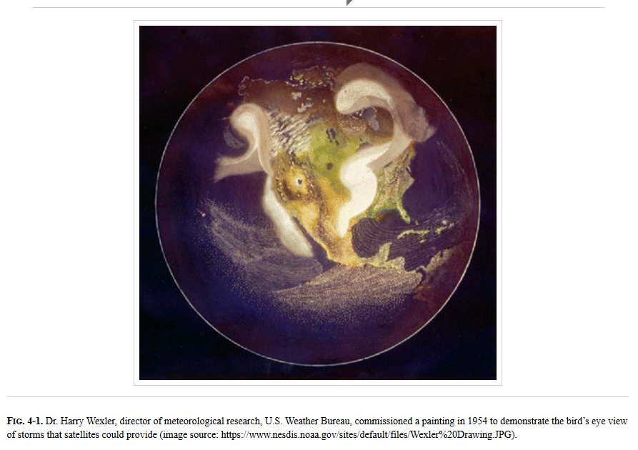
AMS Monograph Published on Clouds from Satellites: Many monographs are planned as part of the 100th anniversary of the American Meteorological Society (AMS). One of these covers the remote sensing of clouds and was recently published: https://journals.ametsoc.org/doi/full/10.1175/AMSMONOGRAPHS-D-18-0009.1. The citation is: Ackerman, S.A., S. Platnick, P.K. Bhartia, B. Duncan, T. L’Ecuyer, A. Heidinger, G. Skofronick-Jackson, N. Loeb, T. Schmit, and N. Smith, 2018: Satellites See the World’s Atmosphere. Meteorological Monographs, 59, 4.1–4.53, https://doi.org/10.1175/AMSMONOGRAPHS-D-18-0009.1. (T. Schmit, E/RA2, 608-263-0291, tim.j.schmit@noaa.gov; S. Ackerman, CIMSS, 608-263-3647)
 (Click image to enlarge)
Figure: Figure 4-1 from the AMS monograph on Satellites. Shows the 1954 painting of what the Earth might look like from space.
Polar Winds from Metop-C: The polar winds team at the Cooperative Institute for Meteorological Satellite Studies (CIMSS) has begun deriving winds over the Arctic and Antarctic using data from the recently launched Metop-C satellite. This utilizes the same technique that is applied to the Advanced Very High Resolution Radiometer (AVHRR) 11 micron images from the other Metop and NOAA polar orbiting satellites. Initial evaluation of the Metop-C winds at CIMSS and Fleet Numerical Meteorology and Oceanography Center (FNMOC) indicate the quality is similar to the Metop-A and -B AVHRR polar winds. (D. Santek, CIMSS, 608-263-7410; J. Key, E/RA2, 608-263-2605)
 (Click image to enlarge)
Figure: Cloud drift winds over the Arctic derived from a time sequence of Metop-C Advanced Very High Resolution Radiometer (AVHRR) 11 micron images. The wind vectors are color-coded according to height as noted in the figure.
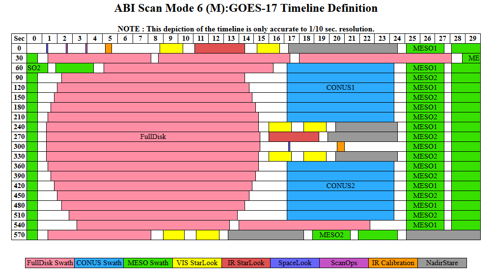
New Scan mode now Operational for both GOES ABIs: On April 2, 2019, new scan modes became routine for both Geostationary Operational Environmental Satellite (GOES)-16 and GOES-17 Advanced Baseline Imager (ABI) which help to improve detection, characterization and monitoring of a broad range of environmental phenomena (mid-latitude and tropical cyclones, fires, volcanic eruptions, aviation hazards, and potential meteor explosions). These modes allow for 10-min (improved from 15-min) full disk scans, plus the 5-min PACUS/CONUS (Pacific/Contiguous U.S.) scans, plus two 1-min mesoscale scans (per satellite). This means that the Full Disk imagery will be at the same cadence as from ABI-like imagers from Japan, S. Korea, and soon Europe; and now at the rate envisioned in 1964 by Professor Verner E. Suomi for the Applications Technology Satellite-1. Additionally, several derived products are now generated more frequently. The genesis of this scan mode began in 2014; more information is on the Cooperative Institute for Meteorological Satellite Studies (CIMSS) Satellite Blog (https://cimss.ssec.wisc.edu/goes/blog/archives/32657). Note that slightly different timelines are used for GOES-16 and GOES-17 (https://www.goes-r.gov/users/abiScanModeInfo.html). (T. Schmit, E/RA2, 608-263-0291, tim.j.schmit@noaa.gov; S. Lindstrom, CIMSS; S. Bachmeier, CIMSS, 608-263-3958; M. Gunshor, CIMSS, 608-263-1146)
 (Click image to enlarge)
Figure: ABI Scan Mode 6 version M timeline, used by GOES-17 (GOES West), which display time (over 10 minutes) on both of the axes and shows the type of scanning (either for calibration or navigation, or collecting energy from the Earth).
ITEMS FOR THE DIVISION CHIEF, CoRP:
CIMSS-led Training at Green Bay National Weather Service Forecast Office: Jordan Gerth and Scott Lindstrom, of the Cooperative Institute for Meteorological Satellite Studies (CIMSS), led convective-season training for operational meteorologists at the National Weather Service forecast office in Green Bay, Wisconsin, on Thursday and Friday, 4 and 5 April 2019. These were one-on-few conversations in front of the Advanced Weather Interactive Processing System (AWIPS) workstations at the office, with focus on the Geostationary Operational Environmental Satellite R-Series (GOES-R) Advanced Baseline Imager (ABI) bands, Channel Differences, Derived Products (including NOAA/CIMSS ProbSevere) and Red-Green-Blue (RGB) composites that are most pertinent to convective forecasting and mesoanalyst roles in operations. Geostationary Lightning Mapper (GLM) data were also discussed. Both trainers led three 3-hour sessions over 1.5 days. The training was done at the request of Gene Brusky, Science and Operations Officer (SOO) at the Green Bay office, and involved all meteorologists on station. (J. Gerth, CIMSS, 608-263-4942, S. Lindstrom, CIMSS)
ISSCWG Meeting: Members of the Advanced Satellite Products Branch (ASPB) and the Cooperative Institute for Meteorological Satellite Studies (CIMSS) attended the first meeting of the International Satellite Solar and Cloud Working Group (ISSCWG) which was held at the Royal Netherlands Meteorological Institute (KNMI) in Utrecht, Netherlands. ISSCWG seeks to coordinate the generation of cloud properties from satellites for use in solar energy applications. A. Walther (CIMSS) attended the meeting in person and briefed the audience on the NOAA cloud properties suite and its use in the National Renewable Energy Lab's (NREL's) solar flux models. A. Heidinger (ASPB) and M. Foster (CIMSS) attended remotely. The solar energy application represents a major customer for NOAA's cloud properties and participation in the ISSCWG is critical. (A. Heidinger, E/RA2, 608-263-6757, andrew.heidinger@noaa.gov)
VISITORS:
NEXT WEEK:
LOOKING AHEAD:
| Archived Weeklies Page | Submit a report item |