[ Archive ]
| CIMSS-NOAA Weekly Report [ Archive ] |
ASPB AND CIMSS WEEKLY HIGHLIGHTS FOR THE WEEK ENDING APRIL 26, 2019
IN THE PRESS:
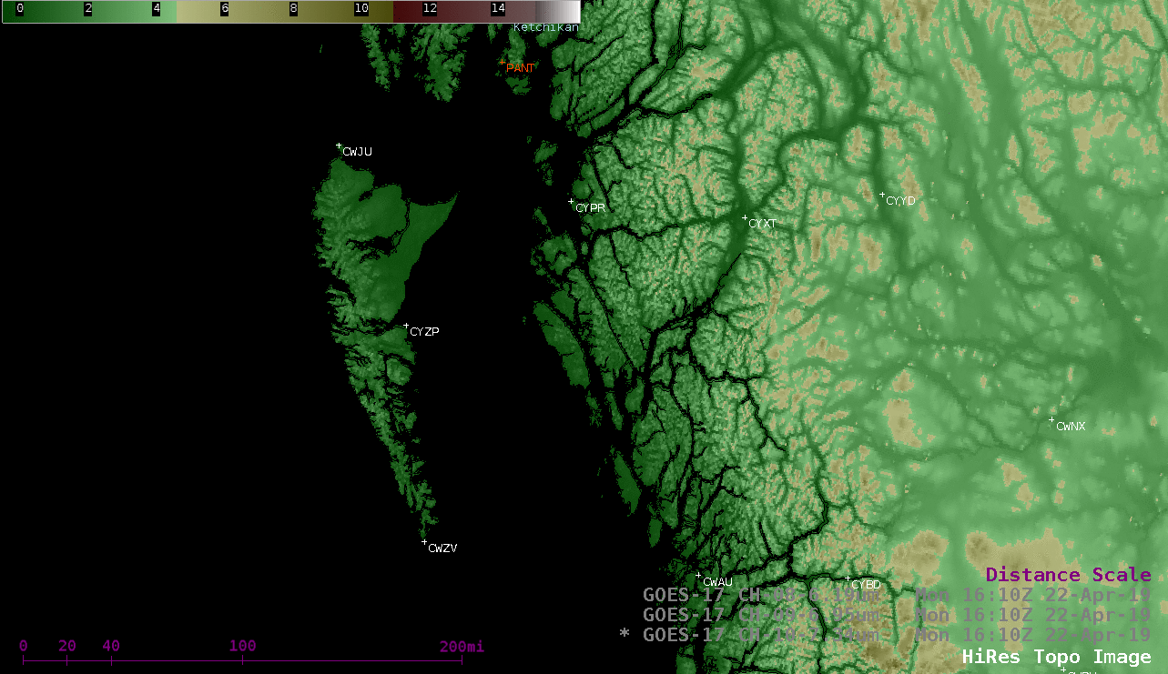
SSEC and CIMSS Scientists in the News: Scientists at the University of Wisconsin-Madison (UW) Space Science and Engineering Center (SSEC) and the Cooperative Institute for Meteorological Satellite Studies (CIMSS) provide expert commentary, interviews, and imagery to news media and participate in events to promote science. In the news this week: 1) CIMSS Director Tristan L’Ecuyer shared his vision for the institute and what he has learned in his first three months in a Q&A with SSEC News (https://www.ssec.wisc.edu/news/articles/11920/). 2) CIMSS Satellite Blog contributor Scott Bachmeier published posts on "Orographically-trapped waves near Haida Gwaii" (Apr. 22), "Flooding in North Dakota, Minnesota and South Dakota" (Apr. 22), and " Unusually dry air over the Upper Midwest" (Apr. 20). Read more at the CIMSS Satellite Blog (http://cimss.ssec.wisc.edu/goes/blog/). (J. Phillips, SSEC, 608-262-8164, T. L'Ecuyer, CIMSS, S. Bachmeier, CIMSS)
 (Click image to enlarge)
Figure: Tristan L’Ecuyer, new director of the UW-Madison Cooperative Institute for Satellite Meteorological Studies (CIMSS). Credit: Eric Verbeten, SSEC.
 (Click image to enlarge)
Figure: GOES-17 (GOES-West) low-level (7.3 µm), mid-level (6.9 µm) and upper-level (6.2 µm) water vapor images on 22 Apr. 2019 revealed orographically-trapped waves propagating westward against the ambient flow over the Haida Strait (between Haida Gwaii and British Columbia) in the wake of a cold frontal passage. The waves formed downwind of Haida Gwaii's 2000-3000 foot terrain and moved eastward, but were reflected back to the west by higher 6000-8000 foot terrain farther inland over British Columbia. Credit: CIMSS.
ITEMS FOR THE ADMINISTRATOR:
ITEMS FOR THE ASSISTANT ADMINISTRATOR:
ITEMS FOR THE OFFICE DIRECTOR, STAR:
Participation in NOAA Workshop on Artificial Intelligence: Allen Huang, Dave Hyman, Tony Wimmers, Willem Marais (Cooperative Institute for Meteorological Satellite Studies, CIMSS), and Mike Pavolonis (NOAA/NESDIS/STAR/ASPB) participated in the 1st NOAA Workshop on Leveraging Artificial Intelligence (AI) in the Exploitation of Satellite Earth Observations and Numerical Weather Prediction (NWP). The workshop was held in College Park, MD from April 23-25, 2019. The CIMSS and ASPB participants contributed oral presentations or posters on recent satellite related developments that utilize or support AI, including data preparation, tropical cyclone analysis, severe weather prediction, and cloud/aerosol classification. In addition, Allen Huang, who served on the workshop organizing committee, moderated a panel discussion on the use of AI in scientific research. The workshop was attended by scientists from academia, government, and the private sector. There was unanimous agreement among the workshop participants that AI is a critical tool for addressing many earth science challenges. (M. Pavolonis, E/RA2, 608-263-9597, Mike.Pavolonis@noaa.gov)
 (Click image to enlarge)
Figure: 1st NOAA Workshop on Leveraging Artificial Intelligence (AI) in the Exploitation of Satellite Earth Observations and Numerical Weather Prediction (NWP) participants.
Manuscript Published on Quantitative Precipitation Estimation with Machine Learning from Combined NWP and AHI: A manuscript titled "Estimating Summertime Precipitation from Himawari-8 and Global Forecast System Based on Machine Learning" has been published in IEEE Transactions on Geoscience and Remote Sensing (Volume: 57, Issue:5, Pages: 2557-2570, Digital Object Identifier: 10.1109/TGRS.2018.2874950). Co-authors are Min Min (CMA) et al. and Jun Li (CIMSS). (Jun Li, Jun.Li@ssec.wisc.edu, 608-262-3755)
Manuscript Published on Historical Aerosol Optical Depth Record over Land from AVHRR: A manuscript titled "A Long-Term Historical Aerosol Optical Depth Data Record (1982–2011) Over China From AVHRR" has been published on IEEE Transactions on Geoscience and Remote Sensing (Volume: 57, Issue:5, Pages: 2467 - 2480, Digital Object Identifier: 10.1109/TGRS.2018.2873944). Co-authors are Ling Gao (CMA), Lin Chen (CMA), Jun Li (CIMSS), Andrew K. Heidinger (STAR) et al. (Jun Li, CIMSS, Jun.Li@ssec.wisc.edu, 608-262-3755)
ITEMS FOR THE DIVISION CHIEF, CoRP:
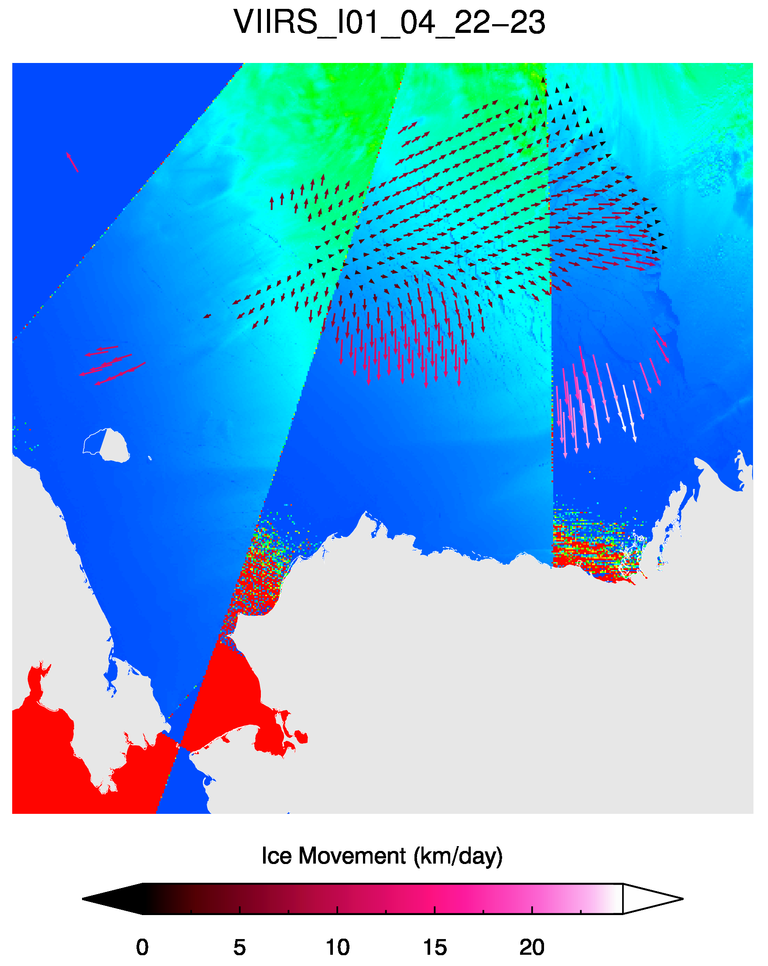
High-Resolution Ice Motion using VIIRS I01-Band: Arctic sea ice motion from Visible Infrared Imaging Radiometer Suite (VIIRS) I01-band daily brightness temperature composites is showing positive results during initial testing. This development is the next step in determining (near-) real-time changes in sea and lake ice from polar-orbiting satellites. Differences between two 375 m VIIRS I-band daily composites can be used to track the small-scale changes in position of individual ice floes as well as changing features in the older ice of the Central Arctic. The output of this product provides the magnitude and direction of sea ice motion throughout the Arctic Ocean. The high spatial resolution of ice motion using the VIIRS I-band (375 m) rather than M-band (750 m) will be useful in the upcoming comparison with Synthetic Aperture Radar (SAR) ice motion, which can detect changes down to 100 m resolution. Output showing movement of the sea ice at this scale can be much more detailed than from other, more conventional microwave-based products such as from Advanced Microwave Scanning Radiometer 2 (AMSR2), which is used for an ice motion product with a spatial resolution of 6.25 km. (A. Letterly, CIMSS, 608-890-1981)
 (Click image to enlarge)
Figure: An example of ice motion output vectors over the Beaufort Sea during April 22-23, 2019. Each arrow represents the typical ice motion in a 25x25 km area. Cracks in the divergent ice areas can be seen in the underlying VIIRS IO1-band image.
Keynote Presentation at Taiwan Severe Weather Workshop: Jordan Gerth, of the Cooperative Institute for Meteorological Satellite Studies (CIMSS), gave a keynote presentation as part of the Severe Weather and Extreme Precipitation (SWEP) workshop, held at Academia Sinica in Taipei, Taiwan (Republic of China), from 24 to 26 April 2019. The title of his presentation was “Compositing visible, near-infrared, and infrared wavelengths for meteorological feature identification”. He also visited the Taiwan Central Weather Bureau (CWB) and gave a presentation on incorporating satellite imagery and products into the Advanced Weather Interactive Processing System (AWIPS), which the CWB also uses for operations. Academia Sinica, the preeminent academic research institution in Taiwan, sponsored the trip. (J. Gerth, CIMSS, 608-263-4942)
VISITORS:
NEXT WEEK:
LOOKING AHEAD:
| Archived Weeklies Page | Submit a report item |