[ Archive ]
| CIMSS-NOAA Weekly Report [ Archive ] |
ASPB AND CIMSS WEEKLY HIGHLIGHTS FOR THE WEEK ENDING MAY 17, 2019
IN THE PRESS:
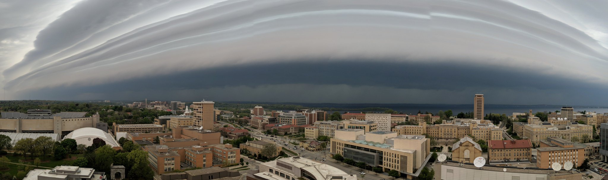
SSEC and CIMSS Scientists in the News: Scientists at the University of Wisconsin-Madison (UW) Space Science and Engineering Center (SSEC) and the Cooperative Institute for Meteorological Satellite Studies (CIMSS) provide expert commentary, interviews, and imagery to news media and participate in events to promote science. In the news this week: 1) The Wall Street Journal interviewed CIMSS researcher Jordan Gerth on the 5G expansion and its potential to interfere with weather forecasts (https://go.wisc.edu/71lgwm). 2) Images of a shelf cloud approaching Madison, WI on May 16, 2019 ahead of a storm appeared on social media, including one widely-shared photo by CIMSS researcher Sarah Griffin (https://twitter.com/smgriffin00; https://go.wisc.edu/459d3b). 3) CIMSS Satellite Blog contributors Scott Bachmeier and Scott Lindstrom published posts on "NUCAPS sounding availability" (May 16), "High pressure centered over Louisiana" (May 15), "Severe thunderstorms in North Carolina" (May 13), "Asian dust entrained into a midlatitude cyclone" (May 12), and "Ash fall streak from the Sheveluch volcano in Kamchatka" (May 12). Read more at the CIMSS Satellite Blog (http://cimss.ssec.wisc.edu/goes/blog/). (J. Gerth, CIMSS, S. Griffin, CIMSS, S. Bachmeier, CIMSS, S. Lindstrom, SSEC)
 (Click image to enlarge)
Figure: Storm approaching the University of Wisconsin-Madison campus area on the morning of May 16, 2019. Credit: S. Griffin, CIMSS.
 (Click image to enlarge)
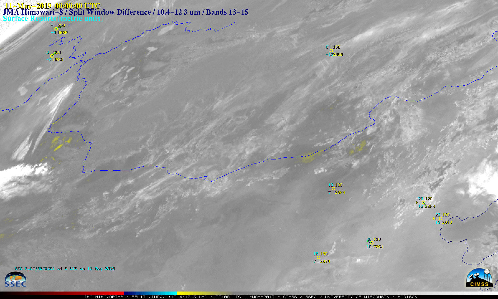
Figure: JMA Himawari-8 Split Window Difference (10.4-12.3 µm) images showed the signature of dust (yellow to cyan enhancement) moving eastward from the desert source region in northwestern China and becoming wrapped into the circulation of the midlatitude cyclone along the Mongolia/China border on May 11, 2019. Credit: CIMSS.
ITEMS FOR THE ADMINISTRATOR:
ITEMS FOR THE ASSISTANT ADMINISTRATOR:
ITEMS FOR THE OFFICE DIRECTOR, STAR:
Great Lakes Regional Collaboration Team Meeting: Claire Pettersen (Cooperative Institute for Meteorological Satellite Studies, CIMSS), Shane Hubbard (CIMSS), Brad Pierce (Space Science and Engineering Center, SSEC) and Mark Kulie (NOAA/NESDIS/STAR/Advanced Satellite Products Branch, ASPB) participated in the 2019 Great Lakes Regional Collaboration Team (GLRCT) Annual In-Person meeting at the University of Wisconsin-Madison from May 14-16, 2019. Pettersen and Kulie presented during the “Celebrating our Work in Wisconsin” session and both served as panel members for the “Science and Research Partnership” session, while Hubbard served as a presenter/panelist at the “Congressional Roundtable: Science and Citizen Safety” session. Pierce provided introductory remarks and a CIMSS/SSEC overview for the Congressional Roundtable session. Pettersen and Kulie also served as the respective CIMSS and ASPB GLRCT team representatives. The goals of the meeting were to provide a forum for GLRCT members to interact and increase their respective knowledge of the GLRCT and team members, strengthen the cohesiveness of the team and improve team effectiveness, increase member knowledge of and interaction with regional partners in the area, host a Wisconsin Congressional Roundtable session, host a Tribal Engagement Workshop, and host an emergency response workshop. (M. Kulie, E/RA2, 608-263-6583, mark.kulie@noaa.gov, C. Pettersen CIMSS/SSEC, 608-772-6270, S. Hubbard CIMSS/SSEC, 608-263-3712, R. B. Pierce 608-890-1892)
GOES-17 Cloud and LAP Pass Provisional Stage Reviews: A Geostationary Operational Environmental Satellite (GOES)-17 Advanced Baseline Imager (ABI) Provisional Peer Stakeholder - Product Validation Review (PS-PVR) was held for selected cloud products and Legacy Atmospheric profile (LAP) retrieval products. The cloud products included mask, phase and height. The LAP products include temperature and moisture profiles, total precipitable water and several derived stability indices. Both the cloud and LAP products passed to the provisional stage, and focused on the time of stable GOES-17 detector temperatures. The provisional stage means that the products are ready for operational use but has documented known issues; for example the GOES-17 Loop Heat Pipe issue which will be addressed at a later delta review. (A. Heidinger, E/RA2, 608-263-6757, andrew.heidinger@noaa.gov; T. Schmit, E/RA2, 608-263-0291, tim.j.schmit@noaa.gov)
JPSS Maturity Reviews: The Joint Polar Satellite System (JPSS) Cryosphere, Cloud and Volcanic Ash Teams participated in their NOAA-20 Maturity Reviews this week. The products reviewed by the Cryosphere Team includedVisible Infrared Imaging Radiometer Suite (VIIRS) Snow Cover, Ice Surface Temperature, Ice Concentration, Ice Age/Thickness. The ice products were recommended by the Team for Provisional Maturity. The products reviewed by the Cloud Team are attempting to achieve Validated Maturity and include cloud probability, cloud phase/type, cloud height/temperature/pressure, cloud optical depth and particle size, cloud water path, cloud base height and cloud cover layers. In addition, the VIIRS Polar Winds Products underwent a maturity review for Validated Maturity. Lastly, the VIIRS Volcanic Ash products were also reviewed for Validated Maturity. Results of these reviews are pending. Once the results are known, the teams will write README files to capture all of the issues remaining in each of the products. Each team was comprised of many individuals from multiple organizations. (A. Heidinger, E/RA2, 608-263-6757, andrew.heidinger@noaa.gov; J. Key, E/RA2, 608-263-2605, jeff.key@noaa.gov; M. Pavolonis, E/RA2, 608-263-9597, mpav@ssec.wisc.edu)
Manuscript Published on Convolving Hyperspectral Infrared Sounder to Broadband: A manuscript entitled "The Radiance Differences between Wavelength and Wavenumber Spaces in Convolving Hyperspectral Infrared Sounder Spectrum to Broadband for Intercomparison" has been published in the journal Remote Sensing. This article was the collaborative work between the Cooperative Institute for Meteorological Satellite Studies (CIMSS) and the China Meteorological Administration (CMA) and co-authors are Di Di (CMA), Min Min (CMA), Jun Li (CIMSS), and Mathew M. Gunshor (CIMSS). The focus is to quantify the differences in methodology in three aspects critical to remote sensing studies involving infrared sensing concerning measurements made in wavelength vs wavenumber space. The differences between interpolating a broadband spectral response function (SRF) to hyperspectral radiance spectral resolution or vice versa, the differences in calculating brightness temperatures from a broadband multispectral imager by calculating the central wavelength versus the central wavenumber, and the the differences between convolving the radiances to SRF in wavelength or wavenumber space were all quantified. The paper is available at https://www.mdpi.com/2072-4292/11/10/1177/pdf. (J. Li, CIMSS, 608-262-3755, M. Gunshor, CIMSS)
ITEMS FOR THE DIVISION CHIEF, CoRP:
Manuscript Accepted for Publication in Weather and Forecasting: The article "The Advanced Dvorak Technique (ADT) for Estimating Tropical Cyclone Intensity: Update and New Capabilities" has been accepted for publication in the AMS journal Weather and Forecasting. This publication outlines the latest advancements to the ADT-Version 9.0 algorithm, which is currently being implemented into NOAA Operations, and will be released to interested users this coming summer/fall. Authors are Tim Olander and Chris Velden of CIMSS. Real-time output from the algorithm is available on the CIMSS Tropical Cyclone webpage at http://tropic.ssec.wisc.edu/real-time/adt. (T. Olander, CIMSS, 608-265-8005)
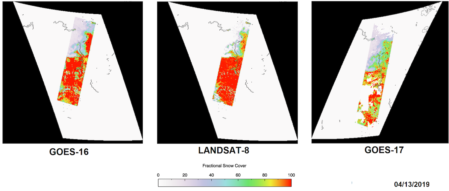
Fractional Snow Cover Agreement among GOES-16,-17, Landsat: Comparisons between the Fractional Snow Cover (FSC) product from the Geostationary Operational Environmental Satellite (GOES) 16 and GOES-17 Advanced Baseline Imager (ABI) show agreement with derived snow cover from Landsat-8. The high-resolution snow cover from Landsat will be used to compare and validate the ABI fractional snow products in the upcoming Enterprise snow cover algorithm migration process. The results of the FSC algorithm (used for ABI) are shown below compared to Landsat over North Dakota and South Dakota during April 13, 2019. Results of the Visible Infrared Imaging Radiometer Suite (VIIRS) single-channel reflectance snow algorithm applied to GOES imagery will be available, soon. (A. Letterly, CIMSS, 608-890-1981)
 (Click image to enlarge)
Figure: Fractional Snow Cover from GOES-16 ABI (left), Landsat-8 (center), and GOES-17 ABI (right) capture the snow cover in the Dakotas along the Missouri River on April 13, 2019. All three satellite products show decreased snow cover fraction to the north and increasing snow cover to the east and south.
VISITORS:
NEXT WEEK:
LOOKING AHEAD:
| Archived Weeklies Page | Submit a report item |