[ Archive ]
| CIMSS-NOAA Weekly Report [ Archive ] |
ASPB AND CIMSS WEEKLY HIGHLIGHTS FOR THE WEEK ENDING JUNE 7, 2019
IN THE PRESS:
SSEC and CIMSS Scientists in the News: Scientists at the University of Wisconsin-Madison (UW) Space Science and Engineering Center (SSEC) and the Cooperative Institute for Meteorological Satellite Studies (CIMSS) provide expert commentary, interviews, and imagery to news media and participate in events to promote science. In the news this week: 1) CIMSS researcher Derrick Herndon explained the benefits of the new Geostationary Operational Environmental Satellites (GOES) to hurricane forecasting. The story was published in The Palm Beach Post: https://go.wisc.edu/28d8f4. 2) NOAA NESDIS contacted CIMSS scientist Scott Bachmeier for more information on his Tweet of June 2 on smoke from the Alberta, Canada wildfire that reached the British Isles: https://go.wisc.edu/r27onb. 3) CIMSS Satellite Blog contributor Scott Bachmeier published posts on "Lake Michigan lake breeze" (June 5), "Severe thunderstorms in Minnesota" (June 4), "Thunderstorms in the Alaska Interior" (June 2), and "Flooding along portions of the Mississippi River" (June 1). Read more at the CIMSS Satellite Blog: http://cimss.ssec.wisc.edu/goes/blog/. (D. Herndon, CIMSS, S. Bachmeier, CIMSS, J. Phillips, SSEC, 608-262-8164)
 (Click image to enlarge)
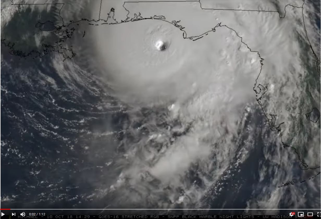
Figure: GOES-East satellite imagery of Category 5 Hurricane Michael making landfall near Mexico Beach, FL on Oct. 10, 2018: https://youtu.be/Lsy_8YHBJn8. Credit: Space Science and Engineering Center, University of Wisconsin-Madison.
 (Click image to enlarge)
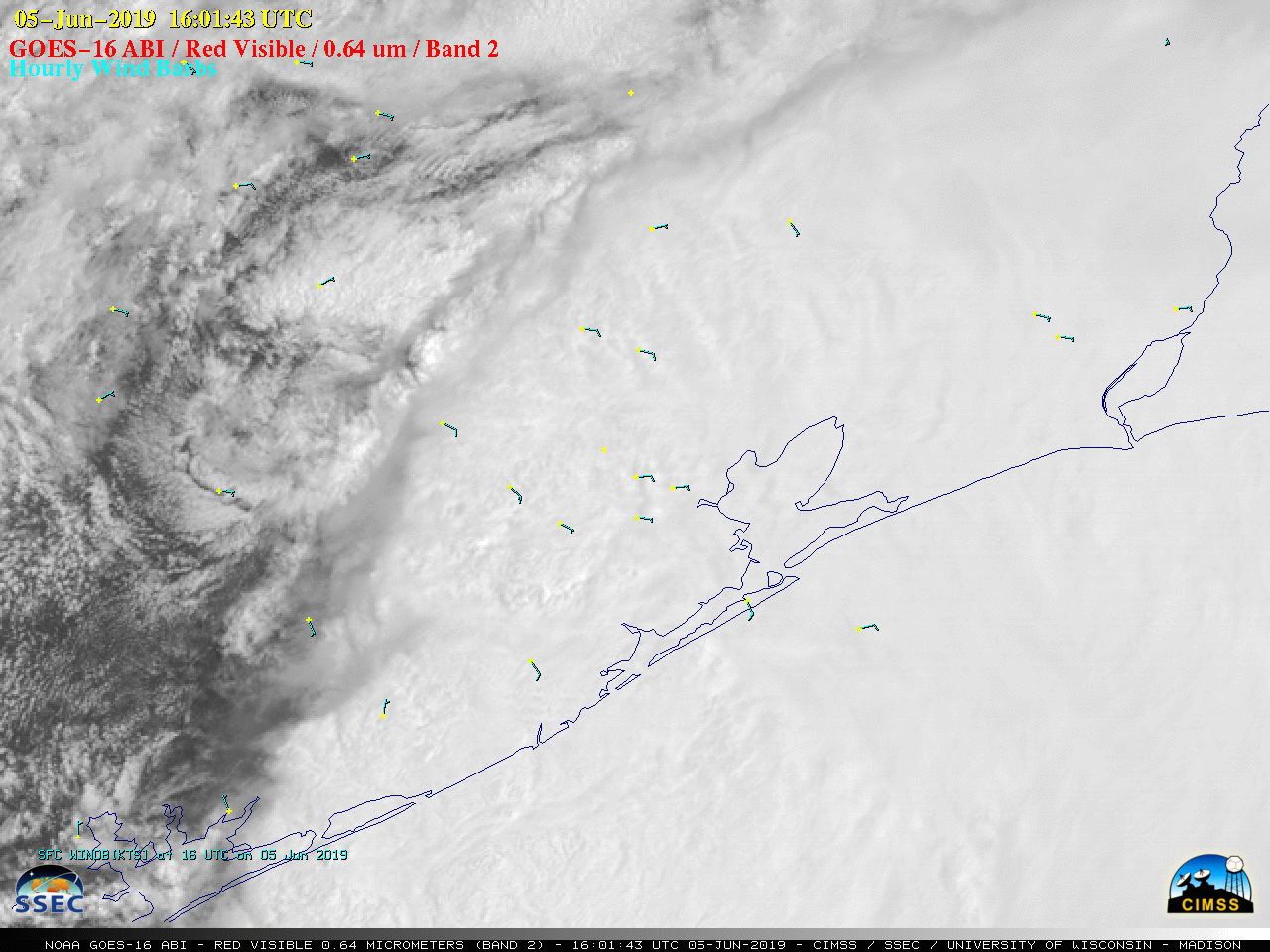
Figure: A CIMSS Satellite Blog post describes GOES-16 (GOES-East) “Red” Visible (0.64 µm) imagery that revealed a mesoscale vortex near the Texas coast on 05 June 2019. Credit: Cooperative Institute for Meteorological Satellite Studies, University of Wisconsin-Madison.
ITEMS FOR THE ADMINISTRATOR:
ITEMS FOR THE ASSISTANT ADMINISTRATOR:
ITEMS FOR THE OFFICE DIRECTOR, STAR:
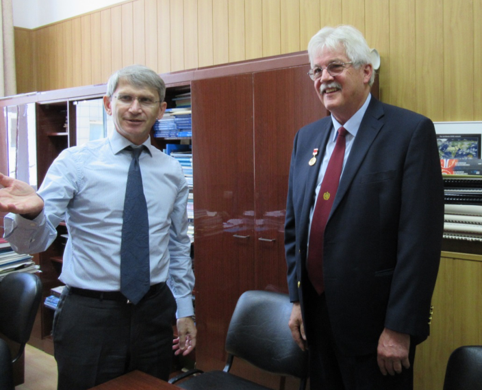
Satellite Training in Moscow: Paul Menzel attended the WMO (World Meteorological Organization) training event on satellite monitoring and nowcasting of high impact weather events for National Hydrometeorological Services of CIS (Commonwealth of Independent States) countries held in Moscow, Russia from 4 to 7 June 2019. The training was conducted by SRC (State Research Center) Planeta of Roshydromet with EUMETSAT assistance. Sixty-five (65) meteorologists attended. Dr Menzel gave an invited talk on "A Historical Perspective on Nowcasting with Geostationary Measurements." Prior to the training event, SRC Planeta awarded Dr. Menzel the Yuri Gagarin Medal in recognition for his decades of contributions to environmental satellite applications research and training. (P. Menzel, CIMSS, 608-263-4930, paulm@ssec.wisc.edu)
 (Click image to enlarge)
Figure: SRC Planeta Director Dr. Vasily Asmus awarding Dr Menzel the Yuri Gagarin Medal on 4 June 2019.
Articles Published: Three articles were recently published in Nature journals (links are available at https://www.ssec.wisc.edu/~kossin/pubs.html): Kossin, J. P., 2019: Reply to: Moon, I.-J. et al.; Lanzante, J. R. Nature, 570, E16-E22. Hall, T. M., and J. P. Kossin, 2019: Hurricane stalling along the North American coast and implications for rainfall. npj Clim. Atmos. Sci., 2, doi:10.1038/s41612-019-0074-8. Ting, M., J. P. Kossin, S. J. Camargo, and C. Li, 2019: Past and future hurricane intensity change along the U.S. East Coast. Scientific Reports, 9:7795, 10.1038/s41598-019-44252-w. All three papers document changes in hurricane behavior along the U.S. coast. In particular, there has been a significant and substantial trend toward slower-moving and meandering hurricanes over the conterminous U.S., such as Harvey (2017) or Florence (2018), over the past 100 years. There is also evidence that a natural climate barrier to hurricanes that resides along the U.S. East Coast is being eroded by greenhouse gas concentrations. The combination of these effects has likely increased U.S. hurricane risk substantially and will continue to increase risk over this century. (J. Kossin, CIMSS, 608-265-5356)
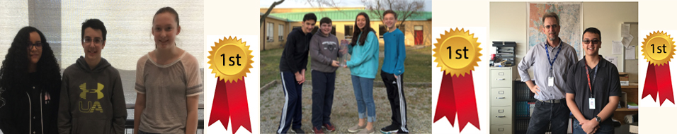
GOES 16/17 Virtual Science Fair Winners Announced: Winning projects in the first-ever GOES-16/17 (Geostationary Operational Environmental Satellite) Virtual Science Fair were announced this week from the Cooperative Institute for Meteorological Satellite Studies (CIMSS). Two Middle School teams tied for 1st place: Auburn, Massachusetts and Medford, New Jersey. The High School 1st place project was from Santa Fe, New Mexico. See all the posters and watch student presentations at http://cimss.ssec.wisc.edu/education/goesr/vsf. (M. Mooney, CIMSS, 608-265-2123, T. Schmit, E/RA2, 608-263-0291, M. Gunshor, CIMSS608-263-1146)
 (Click image to enlarge)
ITEMS FOR THE DIVISION CHIEF, CoRP:
Presentation at the 2019 Joint Center for Satellite Data Assimilation Workshop: Tom Greenwald (Cooperative Institute for Meteorological Satellite Studies, CIMSS) presented at the 17th Joint Center for Satellite Data Assimilation (JCSDA) Science and Technical Workshop held at NASA Headquarters in Washington, DC. Greenwald is a core member of the Community Radiative Transfer Model (CRTM) development team. His talk, “Fast Solvers and Polarization in the CRTM”, provided updates on speed improvements in the radiative scattering components of the CRTM as well as plans for the inclusion of full polarization. (T. Greenwald, CIMSS, 608-263-3629)
Technology Maturation Program Kick-off meeting: On June 6, the Fiscal Year 2019 Kick-off meeting was held for the Technology Maturation Program (TMP). Two tasks from the Cooperative Institute for Meteorological Satellite Studies (CIMSS) were presented: "Exploiting the TROPOMI sensor" and "Demonstrating the Benefits of a Tundra Orbit". Both were positively received and are in their second years. (T. Schmit, E/RA2, 608-263-0291, tim.j.schmit@noaa.gov; R.B. Pierce, SSEC; J. Li, CIMSS, 608-262-3755; Z. Li, CIMSS, 608-890-1982)
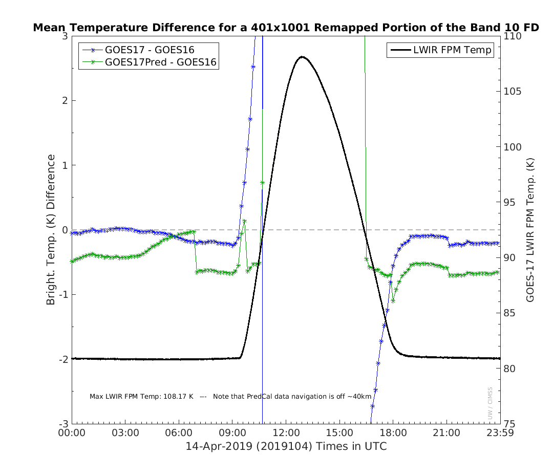
First Look at April GOES-17 Predictive Calibration dataset: The Cooperative Institute for Meteorological Satellite Studies (CIMSS) acquired two days of Geostationary Operational Environmental Satellite (GOES)-17 Advanced Baseline Imager (ABI) data, reprocessed by Harris Corp., with the planned Predictive Calibration modification. These April 13-14 data are from the hottest time of the year for the GOES-17 focal plane temperatures. The data were compared, as well as the original GOES-17 data, to the corresponding GOES-16 data. Within one day of data acquisition, feedback was given to the GOES-R Program Office and others, including the overall improvement in the calibration and a description of several unexpected artifacts, such as a 40 km offset and several discontinuities. During the times just before and after saturation, the predictive calibration results were much improved over the original values. (M. Gunshor, CIMSS, 608-263-1146; J. Nelson, CIMSS, 608-263-6013; W. Straka III, CIMSS; T. Schmit, E/RA2, 608-263-0291, tim.j.schmit@noaa.gov)
 (Click image to enlarge)
Figure: A GOES-16 versus GOES-17 brightness temperature difference plot covering the co-located region between the satellites. There is a GOES-17 version with the original data and one with the predictive calibration results. During the times just before and after saturation, the predictive calibration results were much improved over the original values.
VISITORS:
NEXT WEEK:
LOOKING AHEAD:
| Archived Weeklies Page | Submit a report item |