[ Archive ]
| CIMSS-NOAA Weekly Report [ Archive ] |
ASPB AND CIMSS WEEKLY HIGHLIGHTS FOR THE WEEK ENDING JUNE 14, 2019
IN THE PRESS:
SSEC and CIMSS Scientists in the News: Scientists at the University of Wisconsin-Madison (UW) Space Science and Engineering Center (SSEC) and the Cooperative Institute for Meteorological Satellite Studies (CIMSS) provide expert commentary, interviews, and imagery to news media and participate in events to promote science. In the news this week: 1) This spring, the Automatic Weather Station Program led by SSEC scientist Matthew Lazzara received endorsement from the international sponsors of the Year of Polar Prediction (YOPP). Over the last 40 years, the UW has developed one of the largest Antarctic meteorological observing networks. See article 14 in the YOPP Newsletter: https://go.wisc.edu/22go83. 2) CIMSS Satellite Blog contributor Scott Bachmeier published posts on the "Reflection of sunlight from the Topaz Solar Farm in southern California" (June 12), "Anomalous cutoff low over the Beaufort Sea" (June 12), "30-second imagery of severe thunderstorms across Nebraska and Kansas" (June 8), and "Inland intrusion of marine stratus in south-central Alaska" (June 8). Read more at the CIMSS Satellite Blog: http://cimss.ssec.wisc.edu/goes/blog/. (M. Lazzara, SSEC, S. Bachmeier, CIMSS, J. Phillips, SSEC, 608-262-8164)
 (Click image to enlarge)
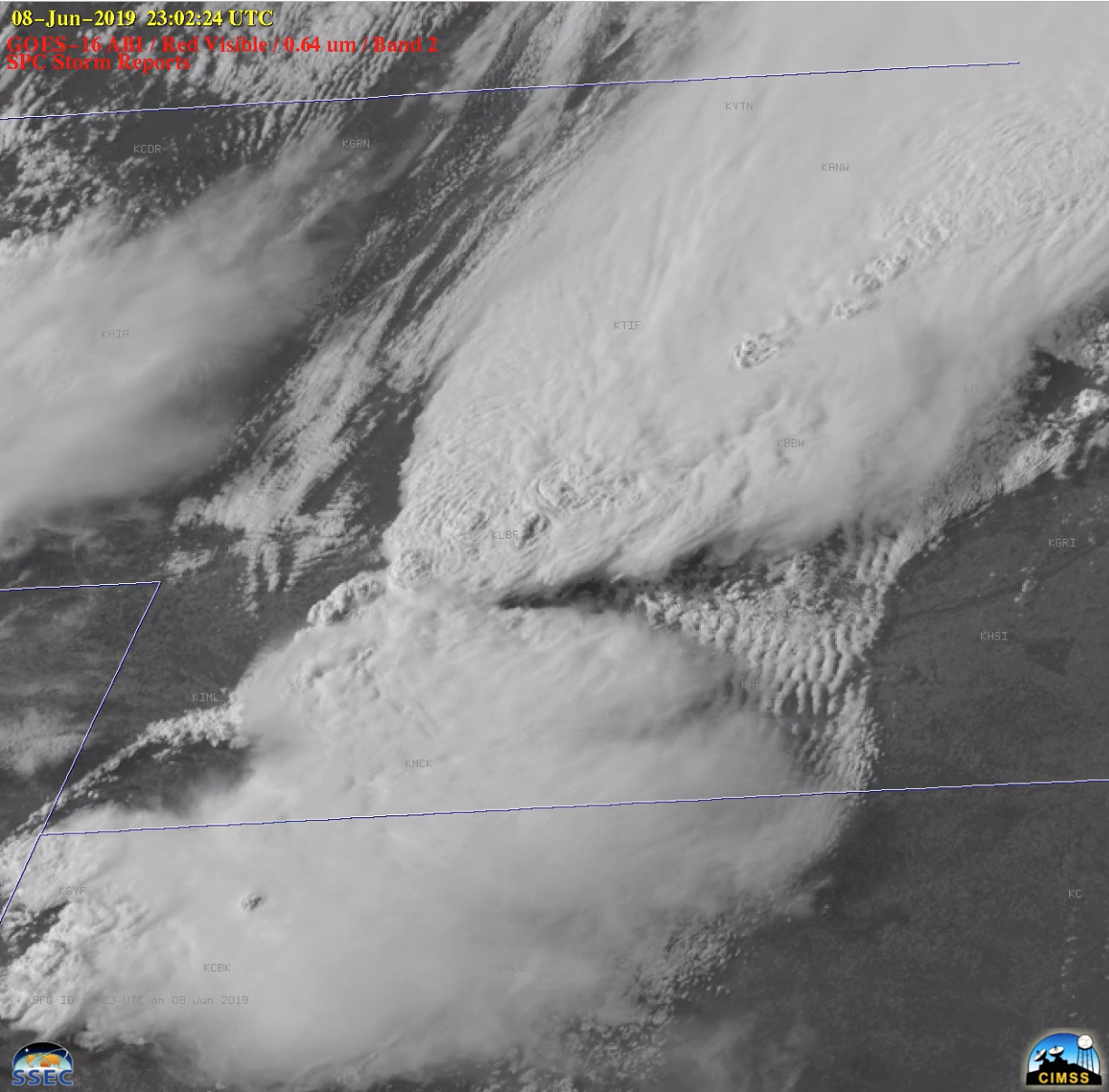
Figure: 30-second images from GOES-16 (GOES-East) of severe thunderstorms that developed across central Nebraska and northern Kansas along, and ahead of, an advancing frontal boundary on 08 June 2019. Click for animation. Credit: CIMSS.
ITEMS FOR THE ADMINISTRATOR:
ITEMS FOR THE ASSISTANT ADMINISTRATOR:
ITEMS FOR THE OFFICE DIRECTOR, STAR:
Meeting on Remote Sensing Support for Volcanic Hazard Mitigation: Mike Pavolonis (NOAA/NESDIS/STAR) participated in the third and final meeting of the United States Geological Survey (USGS) Powell Center Working Group on optimizing satellite resources for the global assessment and mitigation of volcanic hazards. The meeting was held June 10-14, 2019 at the Powell Center in Fort Collins, CO. The USGS Powell Center is a scientist-driven institution where leveraging existing research efforts produces powerful new insights and moves scientific understanding and its inclusion into management forward at an accelerated pace. The primary focus of the meeting was to draft a Scientific Investigation Report (SIR) and several supporting journal papers. The SIR will be used to communicate remote sensing needs, for effective volcanic hazard mitigation, to space agencies. (M. Pavolonis, E/RA2, 608-263-9597, Mike.Pavolonis@noaa.gov)
Tornado Modeling Science Presented at National Conferences: On June 3, 2019, Leigh Orf presented "Petascale supercell thunderstorm simulations and a new hypothesis for tornado formation and maintenance" at the 2019 joint Congress of the Canadian Society for Mechanical Engineering (CSME) and the CFD Society of Canada (CFDSC), a wind engineering conference hosted at the University of Western Ontario. On June 4, Cooperative Institute for Meteorological Satellite Studies (CIMSS) graduate student Kelton Halbert presented "Simulation and Analysis of Severe Thunderstorms On Blue Waters" at the 2019 Blue Waters Symposium in Sunriver, OR. Both talks highlight recent 10 meter 1/4 trillion grid zone simulations of a tornadic supercell thunderstorm. Both talks are available in video form at the following links: https://youtu.be/5cel1fLxR04 and https://youtu.be/wz6Zk9YX88E. (L. Orf, CIMSS, 608-890-1983)
 (Click image to enlarge)
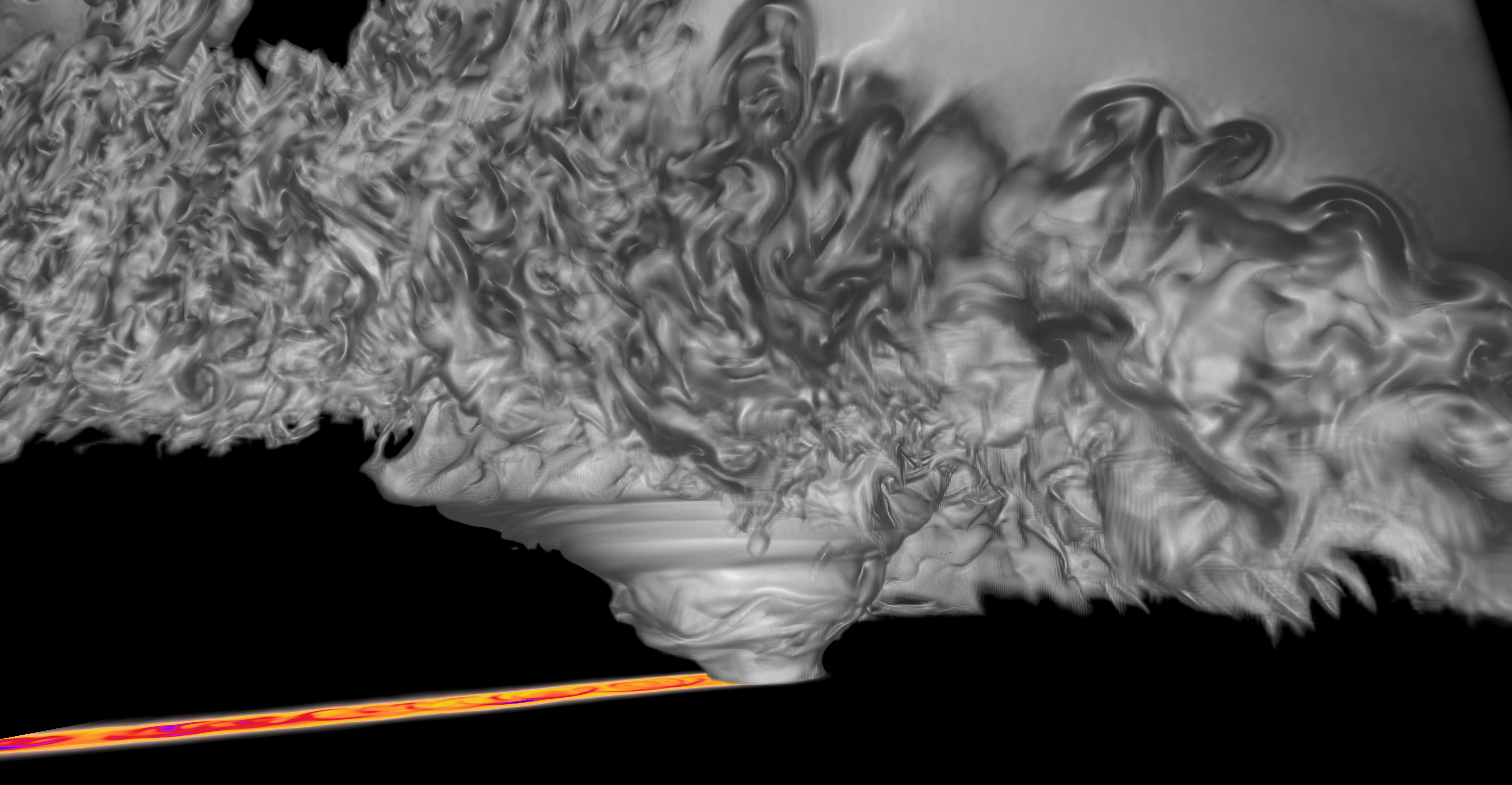
Figure: Cloud field and pressure trace of a 10 meter supercell simulation, showing a multiple vortex EF5 tornado.
CIMSS Investigates Extreme Solar Reflection off California Solar Farm: Scientists at the Cooperative Institute for Meteorological Satellite Studies (CIMSS) working with NOAA's Advanced Satellite Products Branch (APSB) investigated and reported an extreme case of solar reflectance detected by the Advanced Baseline Imager (ABI) on Geostationary Operational Environmental Satellite (GOES)-17 off the Topaz Solar Farm, located in southern California. When the sun/earth/satellite geometry is right, the reflection off the solar farm back to the ABI instrument is strong enough to saturate the detectors on multiple ABI bands. It can be seen in most surface-viewing bands including the infrared bands, and for short time periods the "Cold Pixels Around Fires" (CPAF) effect is seen in the fire detection band 7 (3.9 micrometer) as well as a newly noted effect, "Dark Areas Around Bright Objects" (DAABO) in the visible 0.64 micrometer band 2. The reason this case initially attracted researcher's attention is that the effect is so strong in the 0.64 micrometer band that it causes "vertical", or north-south, stripes that extend for the entire height of the ABI swath, likely related to saturated ABI detector column amplifiers due to an excess charge induced by intense sunlight reflected off the solar farm. This effect was first notable 22 days before the summer solstice, on May 30, 2019. It continues daily, and is expected to continue to be notable for approximately 22 days after the solstice (June 21). CIMSS reported this artifact to the GOES-R Calibration Working Group (CWG) and shared more information on the CIMSS Satellite Blog: http://cimss.ssec.wisc.edu/goes/blog/archives/33504. (T. Schmit, E/RA2, 608-263-0291, tim.j.schmit@noaa.gov, S. Bachmeier, CIMSS, M Gunshor, CIMSS, C. Schmidt, CIMSS)
 (Click image to enlarge)
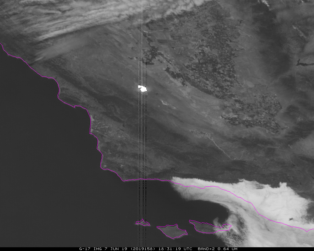
Figure: Band 2 (0.64 micrometer) of the Geostationary Operational Environmental Satellite (GOES)-17 Advanced Baseline Imager (ABI) at 18:31 UTC on June 19, 2019 showing the reflection off the Topaz Solar Farm in Southern California and the vertical stripes that result.
ITEMS FOR THE DIVISION CHIEF, CoRP:
Community Climate Change Presentation: Margaret Mooney from NOAA's Cooperative Institute for Meteorological Satellite Studies (CIMSS) presented on "Climate Change in Wisconsin and Beyond" at the First United Methodist Church in Madison, Wisconsin on Sunday June 9th, launching a local faith-based response to the climate crisis. Mooney shared data from NOAA and the Wisconsin Initiative for Climate Change Impacts (WICCI). Forty-eight (48) people attended and twelve joined a new carbon footprint reduction group forming at the church. (M. Mooney, CIMSS, Margaret.mooney@ssec.wisc.edu)
TROPOMI Seminar given by Brad Pierce: On June 13, the first NOAA/NESDIS Office of Projects, Planning and Analysis (OPPA) Technology Maturation Program (TMP) "brownbag" seminar was held. The remote presentation was given by Brad Pierce which was entitled, "TMP Exploit TROPOspheric Monitoring Instrument (TROPOMI) Sensor Project Status Overview" and showcased the importance of assimilating these new satellite measurements for improved air quality forecasts. (R.B. Pierce, SSEC; T. Schmit, E/RA2, 608-263-0291, tim.j.schmit@noaa.gov)
 (Click image to enlarge)
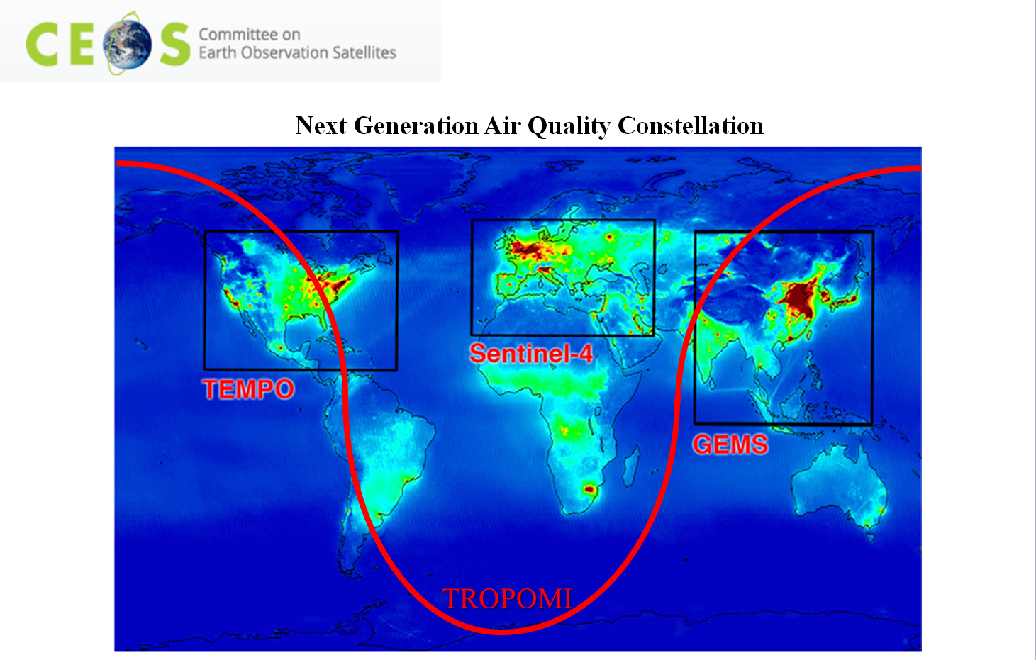
Figure: Next Generation Air Quality Constellation. TROPOMI provides global coverage and intercalibration between the GEO Air Quality (AQ) sensors.
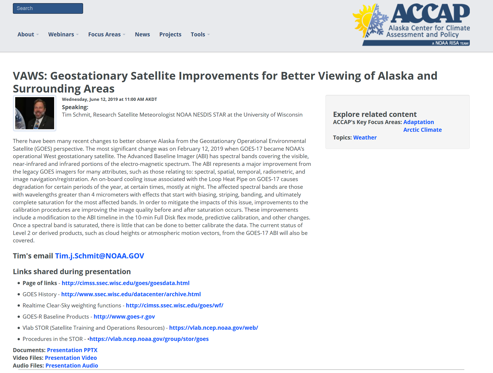
GOES-17 Presentation to Alaska Center for Climate Assessment and Policy: On June 12, Tim Schmit gave a remote seminar to the Alaska Center for Climate Assessment and Policy (ACCAP) / Geographic Information Network of Alaska (GINA) group. There were over 40 participants, including from some from Canada. The title of the talk was "Geostationary Satellite Improvements for Better Viewing of Alaska and Surrounding Areas". It included topics such the new Advanced Baseline Imager (ABI) 10-min Full Disk scan mode, results of the proposed predictive calibration algorithm and many ABI animations showcasing rapidly changing phenomena around Alaska. More information, including the Powerpoint file and various links can be found at https://accap.uaf.edu/VAWS_June2019. (T. Schmit, E/RA2, 608-263-0291, tim.j.schmit@noaa.gov)
 (Click image to enlarge)
Figure: Screen shot of the web page with details from the GOES-17 seminar.
VISITORS:
NEXT WEEK:
LOOKING AHEAD:
| Archived Weeklies Page | Submit a report item |