[ Archive ]
| CIMSS-NOAA Weekly Report [ Archive ] |
ASPB AND CIMSS WEEKLY HIGHLIGHTS FOR THE WEEK ENDING JULY 19, 2019
IN THE PRESS:
SSEC and CIMSS Scientists in the News: Scientists at the University of Wisconsin-Madison (UW) Space Science and Engineering Center (SSEC) and the Cooperative Institute for Meteorological Satellite Studies (CIMSS) provide expert commentary, interviews, and imagery to news media and participate in events to promote science. In the news this week: 1) CIMSS Satellite Blog contributor Scott Bachmeier published posts on "Tropical Storm Barry" (July 11, updated July 12,17). (S. Bachmeier, CIMSS)
 (Click image to enlarge)
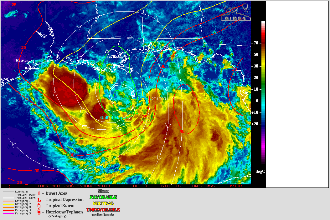
Figure: GOES-16 infrared imagery of Tropical Storm Barry on 11 July 2019 showing contours of deep-layer wind shear. Credit: CIMSS Tropical Cyclone Team.
ITEMS FOR THE ADMINISTRATOR:
ITEMS FOR THE ASSISTANT ADMINISTRATOR:
ITEMS FOR THE OFFICE DIRECTOR, STAR:
Manuscript Published on Global Snowfall Estimates from Spaceborne Radar Observations: A manuscript entitled " Satellite Estimation of Falling Snow: A Global Precipitation Measurement (GPM) Core Observatory Perspective" has been published in the Journal of Applied Meteorology and Climatology. This manuscript features collaborative work between NASA, NOAA, and the University of Wisconsin-Madison Space Science and Engineering Center. Manuscript co-authors are Gail Skofronick-Jackson (NASA), Mark Kulie (NOAA), Lisa Milani (NASA), Stephen J. Munchak (NASA), and Norman Wood (SSEC). The article highlights the GPM Core Observatory's Dual-frequency Precipitation Radar global snowfall estimation capabilities and critically compares GPM estimates to independent CloudSat Cloud Profiling Radar estimates. Efforts to minimize various sensor and algorithm-specific differences were undertaken to highlight GPM-CloudSat comparison best practices to the community. This manuscript is available at https://journals.ametsoc.org/doi/full/10.1175/JAMC-D-18-0124.1. (M. Kulie, E/RA2, 608-263-6583, mark.kulie@noaa.gov)
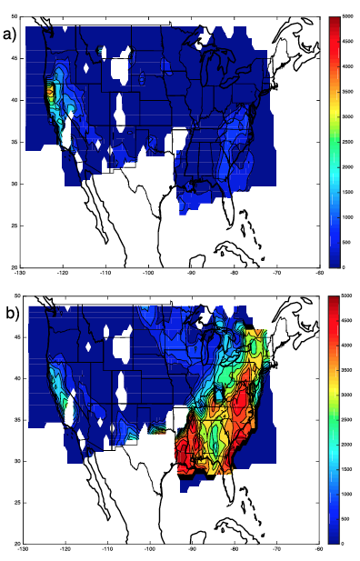
Improved CAPE from JPSS Sounder + Surface Observations Paper Published: A paper was published which demonstrated a technique to use vertical temperature and water vapor profiles derived from the polar-orbiting sounders merged with surface observations of temperature and dewpoint to create an improved estimate of surface-based Convective Available Potential Energy (SB-CAPE) over the continental United States (CONUS) region. This paper used direct broadcast (DB) data from the Suomi-NPP satellite of Cross-track Infrared Sounder (CrIS) and the Advanced Technology Microwave Sounder (ATMS) combined with near-real time surface observations from the NOAA Meteorological Data Ingest System (MADIS). The CrIS/ATMS data was processed using the direct broadcast version of the NOAA Unique Combined Atmospheric Processing System (NUCAPS) to produce vertical profiles of temperature and water vapor. This technique exploits the accuracy of the surface observations to derive a CAPE product that is a significant improvement over the NUCAPS-only estimate. The paper demonstrates a near-real time product that is visualized using SSEC's RealEarth(TM) web service for display on desktops, tablets, and smartphones. The paper can be accessed at https://journals.ametsoc.org/doi/pdf/10.1175/JAMC-D-18-0155.1. (R. Knuteson, SSEC, 608-263-7974, robert.knuteson@ssec.wisc.edu)
 (Click image to enlarge)
Figure: Surface Based CAPE derived from (a) NUCAPS only and (b) NUCAPS + MADIS surface observations.
Final Visit to NWS Pacific Region Headquarters: From 15 through 18 July 2019, Jordan Gerth, of the Cooperative Institute for Meteorological Satellite Studies (CIMSS), made a final visit to the National Weather Service (NWS) Pacific Region Headquarters (PRH) and Honolulu Forecast Office (HFO). Since 2012, he has supported the NWS PRH, HFO, and other forecast offices in the region through tailored satellite meteorology training, specialized applications development, and integrating new weather satellite imagery and products into the Advanced Weather Interactive Processing System (AWIPS). These visits assured that operational meteorologists could access and ably apply data from the Joint Polar Satellite System (JPSS) and Geostationary Operational Environmental Satellite R-Series (GOES-R) missions while providing routine weather services to the Pacific Basin. Jordan Gerth will start as a physical scientist for the NWS Office of Observations in Silver Spring, MD, this August. (J. Gerth, CIMSS, 608-263-4942)
ITEMS FOR THE DIVISION CHIEF, CoRP:
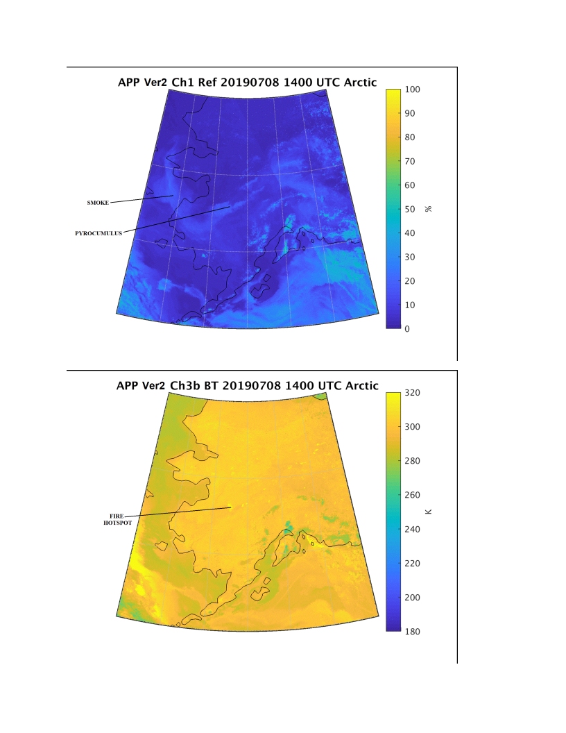
The AVHRR Polar Pathfinder (APP) Captures Large Forest Fires and Smoke Plumes over Alaska: The State of Alaska has been experiencing extreme heat, with McGrath setting a daily high temperature record of 89°F on 8 July 2019 for that day. Associated with the extreme heat were large wildfires evident in the AVHRR Polar Pathfinder (APP) climate data record channel 1 (top) and 3 (bottom) images. The channel 1 image captures the pyrocumulus clouds and smoke plumes that are blown over Norton Sound and Bering Sea around the ridge of high pressure that had settled over the state. The channel 3 image captures hotspots associated with forest fires, especially the large hotspot in west Alaska. Other parts of the Arctic have also set records for high temperature; e.g., see https://globalcryospherewatch.org/extremes/. (R. Dworak, CIMSS)
 (Click image to enlarge)
Figure: APP images of channel 1 (top) and channel 3 (bottom) over the Alaska region on 8 July 2019.
Promoting GOES-R data with Educators: Margaret Mooney from NOAA's Cooperative Institute for Meteorological Satellite Studies (CIMSS) shared resources from the GOES-R Education Proving Ground (http://cimss.ssec.wisc.edu/education/goesr/) at the annual NOAA-supported ESIP Teacher Workshop in Tacoma, Washington on July 17. The Earth Science Information Partners (ESIP) is a large organization supported by NOAA and NASA. CIMSS has collaborated on an annual ESIP teacher workshop since 2009. (M. Mooney, CIMSS, 608-265-2123, T. Schmit, E/RA2, 608-263-0291, S. Lindstrom, CIMSS, M. Gunshor, CIMSS)
VISITORS:
NEXT WEEK:
LOOKING AHEAD:
| Archived Weeklies Page | Submit a report item |