[ Archive ]
| CIMSS-NOAA Weekly Report [ Archive ] |
ASPB AND CIMSS WEEKLY HIGHLIGHTS FOR THE WEEK ENDING AUGUST 23, 2019
IN THE PRESS:
ITEMS FOR THE ADMINISTRATOR:
ITEMS FOR THE ASSISTANT ADMINISTRATOR:
ITEMS FOR THE OFFICE DIRECTOR, STAR:
Paper Published Atmospheric Motion Vectors for Hurricane Applications: A paper was recently published in the journal Remote Sensing on the "Development of Enhanced Vortex-Scale Atmospheric Motion Vectors (AMVs) for Hurricane Applications", by David Stettner, Christopher Velden, Robert Rabin, Steve Wanzong, Jaime Daniels, and Wayne Bresky. The study explores the special processing of enhanced AMVs derived from GOES-16 mesoscale domain sector multispectral imagery with a focus on hurricane applications. Novel methods are applied to optimally extract AMVs from close-in-time image sequences and show that enhanced datasets can be generated on spatiotemporal scales appropriate for mesoscale applications such as hurricanes. (C. Velden, CIMSS, 608-262-9168; D. Stettner, CIMSS; Robert Rabin, NSSL; S. Wanzong, CIMSS; J. Daniels, STAR; W. Bresky, I.M. Systems Group)
ITEMS FOR THE DIVISION CHIEF, CoRP:
Training on Fusion Data for GOES-17 Created: Cooperative Institute for Meteorological Satellite Studies (CIMSS) scientists have created and published training on GOES-17 Data Fusion products designed to provide imagery to replace bands during the Loop Heat Pipe-caused data outages. The recorded training is on YouTube (https://www.youtube.com/watch?v=-RG4sn_yZ2Q). The training describes the bands that lose data, why the data loss occurs, and how plausible imagery for the missing bands are created using imagery from bands that aren't severely affected by the Loop Heat Pipe underperfomance. (S. Lindstrom, CIMSS, 608 263 4425; T. Schmit, NOAA/ASPB )
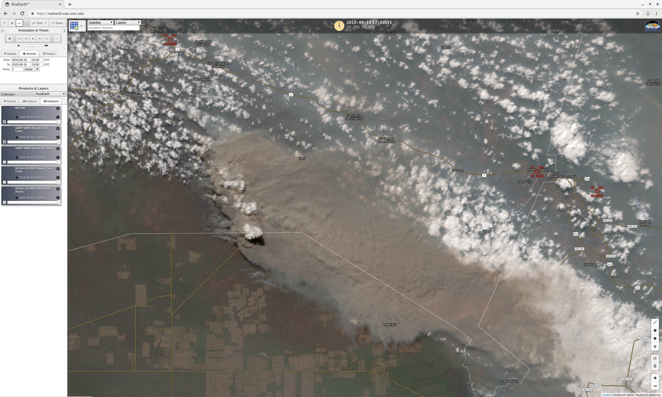
CIMSS Satellite Blog Updates: The Cooperative Institute for Meteorological Satellite Studies (CIMSS) Satellite Blog (https://cimss.ssec.wisc.edu/goes/blog/) was updated with the posts "Split Window Difference fields over the Ocean" (August 20), "Pyrocumulonimbus cloud in Bolivia" (August 18), "Swan Lake Fire in Alaska" (August 17) and "Using NUCAPS soundings to nowcast convective evolution" (August 15). (S. Lindstrom, SSEC, S. Bachmeier, CIMSS)
 (Click image to enlarge)
Figure: Suomi NPP VIIRS True Color image showing a pyrocumulonimbus (pyroCb) cloud over Bolivia on August 18, 2019. This was the second confirmed pyroCb over the South American continent, the second pyroCb documented in the tropics and the first pyroCb documented during a winter season.
VISITORS:
NEXT WEEK:
LOOKING AHEAD:
| Archived Weeklies Page | Submit a report item |