[ Archive ]
| CIMSS-NOAA Weekly Report [ Archive ] |
ASPB AND CIMSS WEEKLY HIGHLIGHTS FOR THE WEEK ENDING SEPTEMBER 6, 2019
IN THE PRESS:
SSEC and CIMSS Scientists in the News: Scientists at the University of Wisconsin-Madison (UW) Space Science and Engineering Center (SSEC) and the Cooperative Institute for Meteorological Satellite Studies (CIMSS) provide expert commentary, interviews, and imagery to news media and participate in events to promote science. In the news this week: 1) UW News and SSEC News published a story on CIMSS scientist Anthony Wimmers' research that explores how an AI model can help improve short-term forecasting of hurricanes: https://www.ssec.wisc.edu/news/articles/12224/. 2) SSEC Honorary Fellow Jordan Gerth talked with Salon about the potential impact of 5G wireless signals on forecasting accuracy: https://go.wisc.edu/n49xzt. 3) In an interview with Spectrum News, CIMSS scientist Shane Hubbard discussed Hurricane Dorian, damage estimates, and the value of building mitigation and resilience into communities post-disaster: https://go.wisc.edu/22n79l. 4) NOAA-20 VIIRS images of Hurricane Dorian processed by CIMSS researcher William Straka III were picked up by news media, including Fox News, Forbes, Weather Underground, Naples News, and The Mirror: https://www.ssec.wisc.edu/news/articles/category/ssec-in-the-news. 5) CIMSS researchers Sarah Griffin and Derrick Herndon talked with WMTV/NBC15 about Hurricane Dorian and tropical cyclone expertise at CIMSS. 6) NPR's Steve Inskeep interviewed NOAA scientist Jim Kossin about why more hurricanes like Dorian are moving at slower speeds, and whether that has anything to do with climate change: https://go.wisc.edu/r8nraf. 7) CIMSS Satellite Blog contributor Scott Bachmeier published posts on "Mesospheric airglow waves over the Northern Plains" (Sept. 2), "Hurricane Dorian reaches Category 5 intensity" (Sept. 1-2), "GOES-17 Loop Heat Pipe data outages reach seasonal peak" (Aug. 30), "Mesospheric airglow waves over the Northern Plains" (Sept. 2), and "Hurricane Dorian off the coast of South Carolina" (September 5, 2019). Read more at the CIMSS Satellite Blog: http://cimss.ssec.wisc.edu/goes/blog/. (T. Wimmers, CIMSS, J. Gerth, SSEC, S. Hubbard, CIMSS, W. Straka III, CIMSS, S. Griffin, CIMSS, D. Herndon, CIMSS, J. Kossin, NOAA, S. Bachmeier, CIMSS, E. Verbeten, SSEC,S. Lindstrom, CIMSS, J. Phillips, SSEC, 608-262-8164)
 (Click image to enlarge)
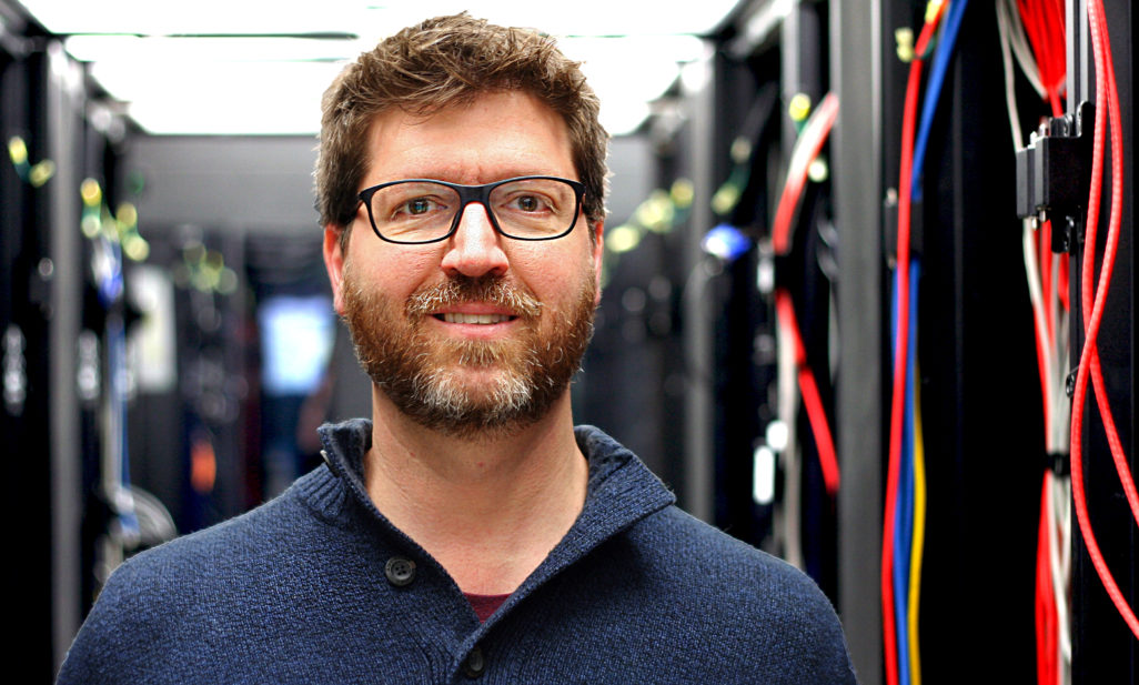
Figure: From SSEC News: CIMSS researcher Anthony Wimmers developed a deep learning AI program to estimate tropical cyclone intensity from satellite passive microwave imagery. Credit: Eric Verbeten.
 (Click image to enlarge)
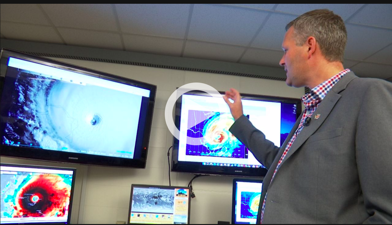
Figure: CIMSS scientist Shane Hubbard discussed Hurricane Dorian with Spectrum News. Credit: Spectrum News.
 (Click image to enlarge)
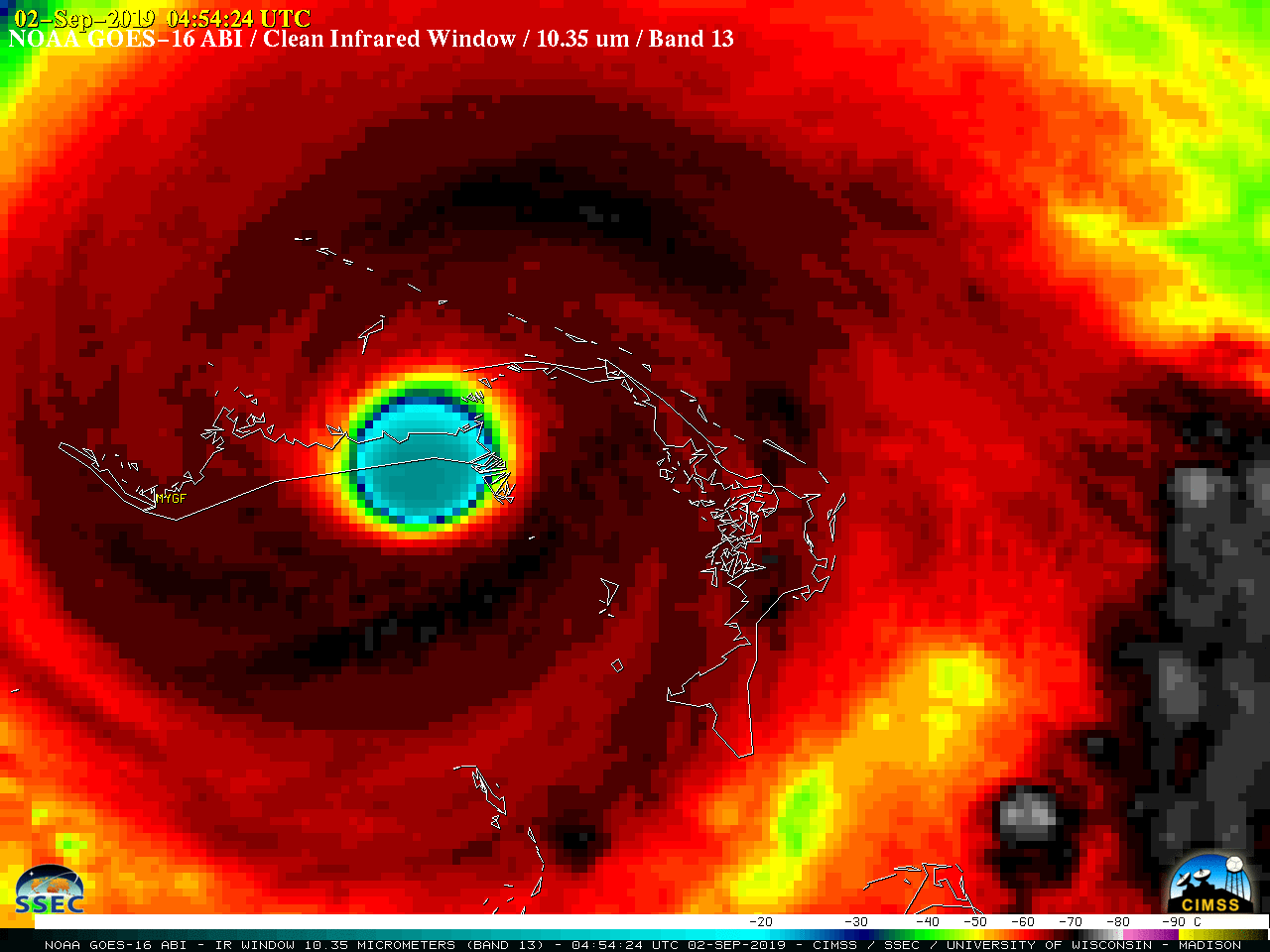
Figure: GOES-16 "Clean" Infrared Window (10.35 µm) image showing the eye of Category 5 Hurricane Dorian over Grand Bahama Island at 0454 UTC on September 2, 2019.
ITEMS FOR THE ADMINISTRATOR:
ITEMS FOR THE ASSISTANT ADMINISTRATOR:
ITEMS FOR THE OFFICE DIRECTOR, STAR:
Satellite Training in American Samoa: Scott Lindstrom, Cooperative Institute for Meteorological Satellite Studies (CIMSS), provided in-person, one-on-one satellite training to forecasters at the Weather Service Office (WSO) in Pago Pago, American Samoa. These satellite conversations over the course of three days covered the different satellite products available in the forecast office on the AWIPS Thin Client, and were tailored to the weather of the day and the forecast problems routinely faced at the office. (Scott Lindstrom, CIMSS, 608 263 4425)
ITEMS FOR THE DIVISION CHIEF, CoRP:
VISITORS:
NEXT WEEK:
LOOKING AHEAD:
| Archived Weeklies Page | Submit a report item |