[ Archive ]
| CIMSS-NOAA Weekly Report [ Archive ] |
ASPB AND CIMSS WEEKLY HIGHLIGHTS FOR THE WEEK ENDING SEPTEMBER 13, 2019
IN THE PRESS:
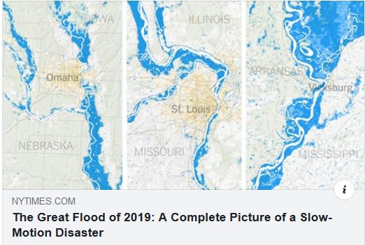
SSEC and CIMSS Scientists in the News: Scientists at the University of Wisconsin-Madison (UW) Space Science and Engineering Center (SSEC) and the Cooperative Institute for Meteorological Satellite Studies (CIMSS) provide expert commentary, interviews, and imagery to news media and participate in events to promote science. In the news this week: 1) The New York Times published a map of this year's flooding across the US by analyzing six months of NOAA/VIIRS data using the CSPP VIIRS Flood Detection Software developed at CIMSS and George Mason University with funding from NOAA: https://go.wisc.edu/ro6yxn. 2) ASPB scientist Tim Schmit and CIMSS scientist Mat Gunshor talked about improving GOES-17 data quality issues in a story published by SSEC News: https://www.ssec.wisc.edu/news/articles/12176/. 3) TechXplore picked up the UW News story on CIMSS scientist Anthony Wimmers' research that explores how an AI model can help improve short-term forecasting of hurricanes: https://go.wisc.edu/0o5aqs. 4) CIMSS Satellite Blog contributor Scott Bachmeier published posts on "Severe thunderstorms in Wyoming, Nebraska and South Dakota" (Sept. 10), "Dorian moves across the Maritime Provinces of Canada" (Sept. 8), "Typhoon Faxai makes landfall in Japan" (Sept. 8), "Hurricane Dorian off the coasts of South Carolina and North Carolina" (Sept. 5). Read more at the CIMSS Satellite Blog: http://cimss.ssec.wisc.edu/goes/blog/. (L. Gumley, CIMSS, T. Schmit, E/RA2, M. Gunshor, CIMSS, A. Wimmers, CIMSS, S. Bachmeier, CIMSS, J. Phillips, SSEC, 608-262-8164)
 (Click image to enlarge)
Figure: Map published by the New York Times of 2019 US flooding created with the CIMSS CSPP VIIRS Flood Detection Software. Credit: New York Times and CIMSS.
 (Click image to enlarge)
Figure: GOES-16 images showed the development of thunderstorms that produced large hail, tornadoes and damaging winds across eastern Wyoming, northern Nebraska and southern South Dakota on Sept. 10, 2019. Credit: CIMSS Satellite Blog.
(Click image to enlarge)
Figure: GOES-16 images showed the development of thunderstorms that produced large hail, tornadoes and damaging winds across eastern Wyoming, northern Nebraska and southern South Dakota on Sept. 10, 2019. Credit: CIMSS Satellite Blog.
ITEMS FOR THE ADMINISTRATOR:
ITEMS FOR THE ASSISTANT ADMINISTRATOR:
ITEMS FOR THE OFFICE DIRECTOR, STAR:
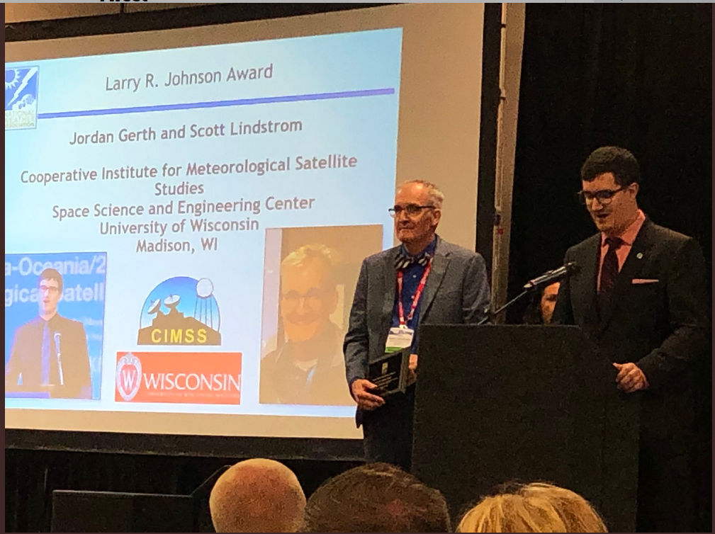
National Weather Association's Larry R. Johnson Award presented to CIMSS Scientists: Scott Lindstrom (Cooperative Institute for Meteorological Satellite Studies, CIMSS) and Jordan Gerth (recently of CIMSS, now at National Weather Service Office of Observations) were presented with the Larry R. Johnson Award at the annual meeting of the National Weather Association in Huntsville AL on 11 September 2019. The award was "For outstanding efforts in educating operational meteorologists on the uses and benefits of the new GOES series of satellites" and recognizes work that started at the Science and Operations Officer (SOO) Prep Course at the National Weather Service Training Center (NWSTC) in 2016 and 2017 and continues to the present in the form of in-person training visits to forecast offices, development of training documents and videos, and blogging about satellite data uses. (S. Lindstrom, CIMSS, 608 263 4425; J. Gerth, NWS/OBS)
 (Click image to enlarge)
Figure: Scott Lindstrom (left) and Jordan Gerth (right) accepting the Larry R. Johnson award at the NWA Meeting. Photo from @Tom_Wachs (Tom Wachs of Channel 6, Milwaukee)
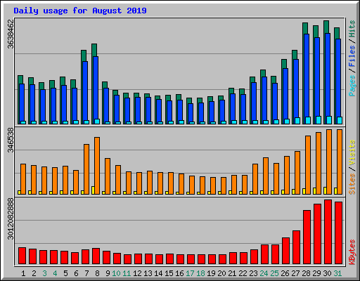
CIMSS Tropical Cyclone Site Active During Hurricane Dorian: Category 5 Hurricane Dorian captured public attention in a big way as it made its way through the Bahamas and up the US southeastern coast. The NESDIS Cooperative Institute for Meteorological Satellite Studies (CIMSS) at the University of Wisconsin (UW) hosts a Tropical Cyclones website (http://tropic.ssec.wisc.edu/) that garnered over 3 million hits/day on average during the event. This site specializes in depicting satellite-derived imagery and products that are not only viewed by the public, but also forecasters at the National Hurricane Center (NHC). The graphic below illustrates the website traffic that ramped up in late August as Dorian approached the Bahamas. (C. Velden, CIMSS, 608-262-9168; T. Olander, CIMSS, 608-265-8005; D. Herndon, CIMSS, 608-262-6741; D. Stettner, CIMSS, 608-262-8850; S. Wanzong, CIMSS, 608-263-1950; S. Griffin, CIMSS; T. Wimmers, CIMSS).
 (Click image to enlarge)
Figure: Daily traffic to the UW-CIMSS Tropical Cyclones web site during August (Hurricane Dorian developed during the last week).
ITEMS FOR THE DIVISION CHIEF, CoRP:
VISITORS:
NEXT WEEK:
LOOKING AHEAD:
| Archived Weeklies Page | Submit a report item |