[ Archive ]
| CIMSS-NOAA Weekly Report [ Archive ] |
ASPB AND CIMSS WEEKLY HIGHLIGHTS FOR THE WEEK ENDING SEPTEMBER 27, 2019
IN THE PRESS:
SSEC and CIMSS Scientists in the News: Scientists at the University of Wisconsin-Madison (UW) Space Science and Engineering Center (SSEC) and the Cooperative Institute for Meteorological Satellite Studies (CIMSS) provide expert commentary, interviews, and imagery to news media and participate in events to promote science. In the news this week: 1) CIMSS scientist Jason Otkin was quoted by the Washington Post and the Bowling Green Daily news regarding development of a flash drought across the southeastern US in recent weeks. Read more: https://go.wisc.edu/421u9p, https://go.wisc.edu/2u3wl8. 2) SSEC News highlighted new research by SSEC scientist Sam Batzli that takes advantage of high-resolution satellite data to help the National Weather Service (NWS) forecast landslides and debris flows after a wildfire. Read more: https://www.ssec.wisc.edu/news/articles/12249/. 3) CIMSS Satellite Blog contributors Scott Bachmeier and Scott Lindstrom published posts on "Hurricane Lorenzo in the Atlantic Ocean" (Sept. 26), "Severe Thunderstorms in the Upper Midwest" (Sep. 24), "Severe thunderstorms in Arizona" (Sept. 23), "30-year anniversary of the landfall of Hurricane Hugo" (Sept. 22, and "Saharan Air Layer plume over the Atlantic Ocean" (Sept. 20). Read more at the CIMSS Satellite Blog: http://cimss.ssec.wisc.edu/goes/blog/. (J. Otkin, CIMSS, S. Batzli, SSEC, S. Bachmeier, CIMSS, S. Lindstrom, SSEC, J. Phillips, SSEC, 608-262-8164)
 (Click image to enlarge)
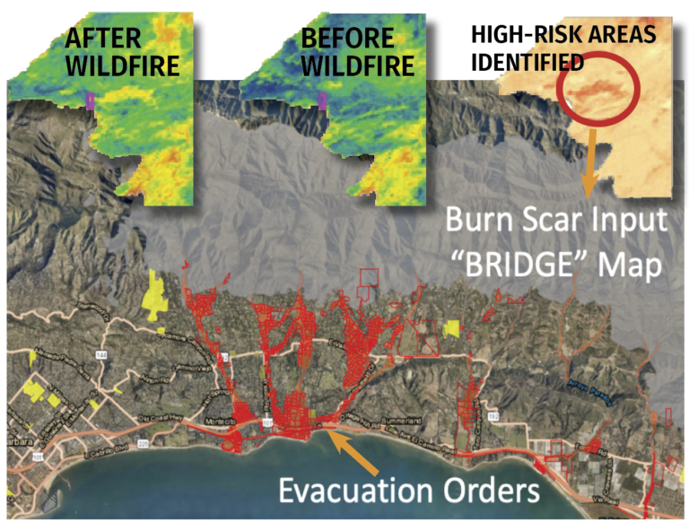
Figure: Example evacuation order map from March 05, 2019. Using the Normalized Difference Vegetation Index (NDVI), BRIDGE Map measures the amount of vegetation before and after a wildfire to determine areas at risk for future landslides. Credits: Santa Barbara County Sheriff and Emergency Operations Center and Sam Batzli, SSEC.
 (Click image to enlarge)
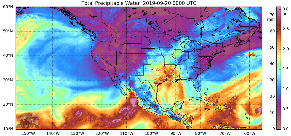
Figure: Much of the moisture helping to fuel the development of severe convection in Arizona on Sept. 23, 2019 was from the remnants of Tropical Storm Lorena in the East Pacific Ocean — the northward transport of this moisture could be seen using the hourly MIMIC Total Precipitable Water product. Credit: CIMSS.
ITEMS FOR THE ADMINISTRATOR:
ITEMS FOR THE ASSISTANT ADMINISTRATOR:
ITEMS FOR THE OFFICE DIRECTOR, STAR:
Paper Published on a Comparison of Satellite-derived Winds: A manuscript titled "2018 Atmospheric Motion Vector (AMV) Intercomparison Study" has been published in the Remote Sensing Special Issue: Satellite-Derived Wind Observations (https://www.mdpi.com/2072-4292/11/19/2240). The paper summarizes a case study comparison of AMVs calculated by six operational centers: NOAA/NESDIS, The Brazil Center for Weather Prediction and Climate Studies (CPTEC), European Organization for the Exploitation of Meteorological Satellites (EUMETSAT), Japan Meteorological Agency (JMA), Korea Meteorological Administration (KMA), and the Satellite Application Facility on Support to Nowcasting and Very short range forecasting (NWCSAF). The evaluation includes a statistical intercomparison of the winds, and comparisons to rawinsondes, model analyses, and the Cloud-Aerosol Lidar and Infrared Pathfinder Satellite Observation (CALIPSO) cloud heights. Also, included is a brief history of satellite-derived winds at the different centers, noting that some of the pioneering work was done at NOAA and the Space Science and Engineering Center/Cooperative Institute for Meteorological Satellite Studies (SSEC/CIMSS). Co-authors are R. Dworak (CIMSS), S. Nebuda (CIMSS), S. Wanzong (CIMSS), J. Daniels (STAR), W. Bresky (IMSG), and representatives from each of the operational centers. (D. Santek, CIMSS, 608-263-7410)
CIMSS Scientist's research on violent tornadoes highlighted:Cooperative Institute for Meteorological Satellite Studies (CIMSS) scientist Leigh Orf's research was recently featured by Futurum Careers (https://futurumcareers.com/using-supercomputers-to-simulate-super-tornadoes), an organization that encourages students from around the world to consider careers in the sciences. Orf also recently presented "Ultra-high resolution supercell simulations visualized with VAPOR v3" at the NCAR International Computers in Atmospheric Sciences conference in Stresa, Italy (Link to video of talk: https://youtu.be/zKTIku7g394). Orf is co-author on an accompanying recently published paper, "VAPOR: A Visualization Package Tailored to Analyze Simulation Data in Earth System" (https://doi.org/10.3390/atmos10090488) and sole author on the recent paper "A Violently Tornadic Supercell Thunderstorm Simulation Spanning a Quarter-Trillion Grid Volumes: Computational Challenges, I/O Framework, and Visualizations of Tornadogenesis" (https://doi.org/10.3390/atmos10100578).
 (Click image to enlarge)
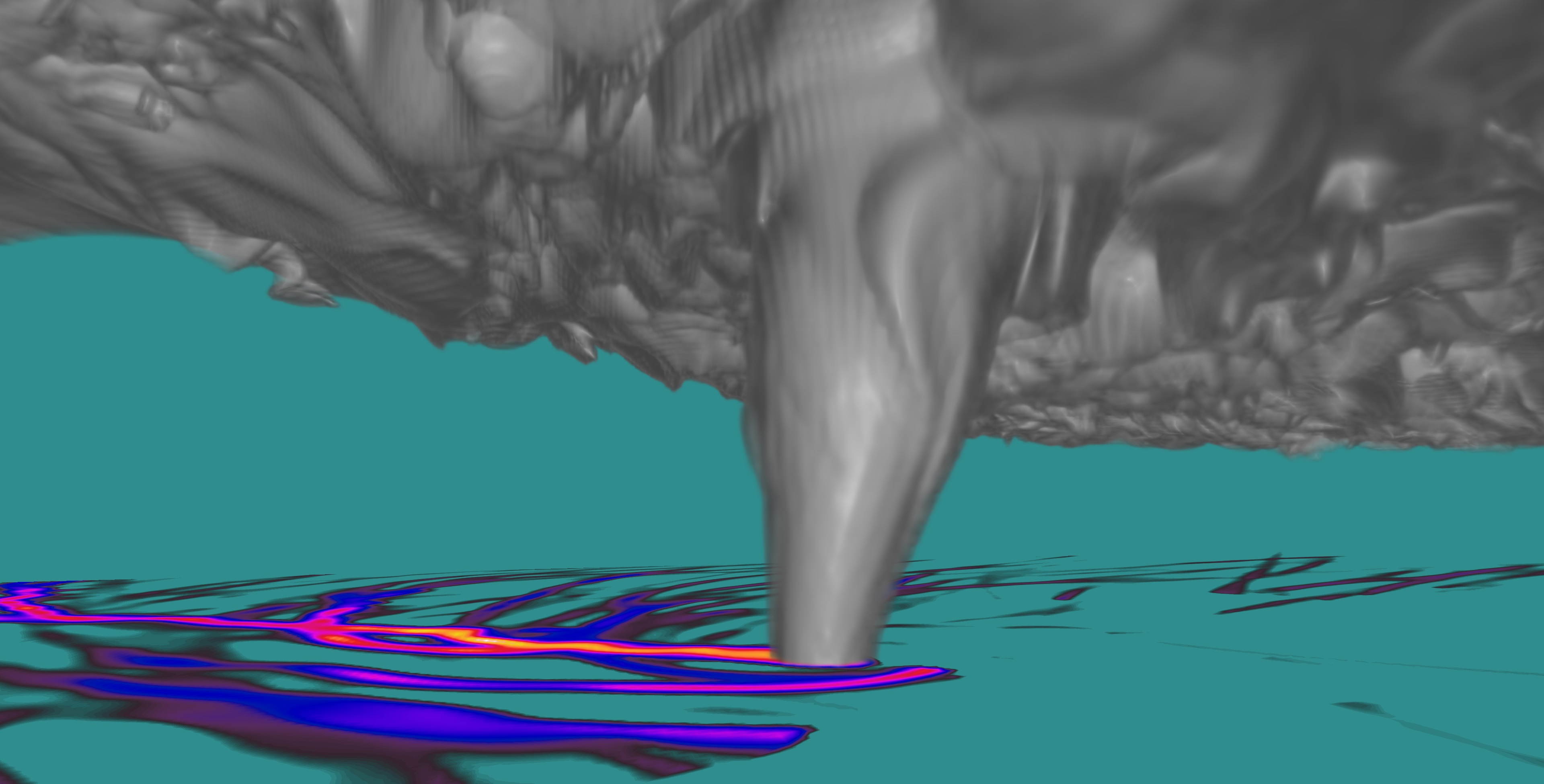
Figure: An image of a simulated tornado and surface vortex paths featured on the a recent Futurum Careers (https://futurumcareers.com) publication.
ITEMS FOR THE DIVISION CHIEF, CoRP:
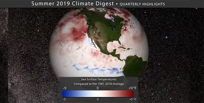
Climate Digest for Science On a Sphere Exhibits: NOAA's Cooperative Institute for Meteorological Satellite Studies (CIMSS) led a collaborative effort to produce an improved Science on a Sphere (SOS) product pairing music representing the Arctic Sea Ice record with NOAA's National Centers for Environmental Information (NCEI) global data for the months of June, July and August 2019. The Climate Digest can be viewed at any science center that has a SOS, and a YouTube version is linked from this web page: https://sphere.ssec.wisc.edu/summer2019/. (M. Mooney, CIMSS, 608-265-2123, R. Kohrs, SSEC, C. Suplinski, SSEC, S. Bachmeier, CIMSS)
 (Click image to enlarge)
VISITORS:
NEXT WEEK:
LOOKING AHEAD:
| Archived Weeklies Page | Submit a report item |