[ Archive ]
| CIMSS-NOAA Weekly Report [ Archive ] |
ASPB AND CIMSS WEEKLY HIGHLIGHTS FOR THE WEEK ENDING OCTOBER 4, 2019
IN THE PRESS:
ITEMS FOR THE ADMINISTRATOR:
ITEMS FOR THE ASSISTANT ADMINISTRATOR:
ITEMS FOR THE OFFICE DIRECTOR, STAR:
CIMSS and ASPB Support the 2019 Joint Satellite Conference: Cooperative Institute for Meteorological Satellite Studies (CIMSS) and STAR Advanced Satellite Products Branch (ASPB) scientists participated broadly in the 2019 Joint Satellite Conference, held September 30 through October 4, 2019 in Boston, MA. Two ASPB and 45 CIMSS scientists supported and participated in the conference as speakers, poster presenters, conference organizers, panel participants, session chairs, student speed mentoring and judging, and answering questions at the NOAA table. Additionally, there were many side meetings including one with the cooperative institute directors. (T. Schmit, E/RA2, 608-263-0291, tim.j.schmit@noaa.gov; J. Key, E/RA2, 608-263-2605, jeff.key@noaa.gov)
 (Click image to enlarge)
CIMSS Researcher Visits EUMETSAT for IASI Evaluation:Cooperative Institute for Meteorological Satellite Studies (CIMSS) researcher Tim Wagner recently returned from a two-week visit to EUMETSAT in Darmstadt, Germany. He worked with the hyperspectral team under the direction of EUMETSAT scientist Thomas August to use Aircraft Meteorological Data Relay (AMDAR) observations to evaluate the performance of the Infrared Atmospheric Sounding Interferometer (IASI) Level 2 thermodynamic profile retrievals. This included conducting a year-long study on the performance of IASI over the continental United States, assisting in the operationalization of the AMDAR/IASI comparison software that he developed, and contributing to the checkout of the IASI instrument aboard the recently launched Metop-C satellite. With a greatly enhanced spatial and temporal observational density as compared to the operational radiosonde network, AMDAR has been shown by this work to be a valuable tool for the evaluation and validation of low-earth orbiting satellites. (T. Wagner, CIMSS, 608-890-1980)
ITEMS FOR THE DIVISION CHIEF, CoRP:
CIMSS Provides Update to GOES-17 FPM Temperature Thresholds for ABI DQFs: Researchers at the Cooperative Institute for Meteorological Satellite Studies (CIMSS) and the Advanced Satellite Products Branch (ASPB) provided the Geostationary Operational Environmental Satellite (GOES)-R Program with an update to the thresholds for when to flag GOES-17 Advanced Baseline Imager (ABI) data during the daily heating period due to the loop heat pipe issue. The thresholds were updated based on analysis of the latest peak instrument heating day, August 30, 2019, and incorporated user feedback about the previous set of thresholds. The thresholds are based on Focal Plane Module (FPM) temperature and GOES-16 vs GOES-17 (GEO-GEO) statistics generated at CIMSS and available on the web at http://cimss.ssec.wisc.edu/goes-r/abi-/band_statistics_imagery.html. These thresholds were deployed operationally by the GOES-R Product Readiness and Operations (PRO) team on October 2, 2019 (https://www.ospo.noaa.gov/data/messages/2019/MSG2751954.html). (T. Schmit, E/RA2, 608-263-0291, tim.j.schmit@noaa.gov, M. Gunshor, CIMSS, J. Nelson, CIMSS).
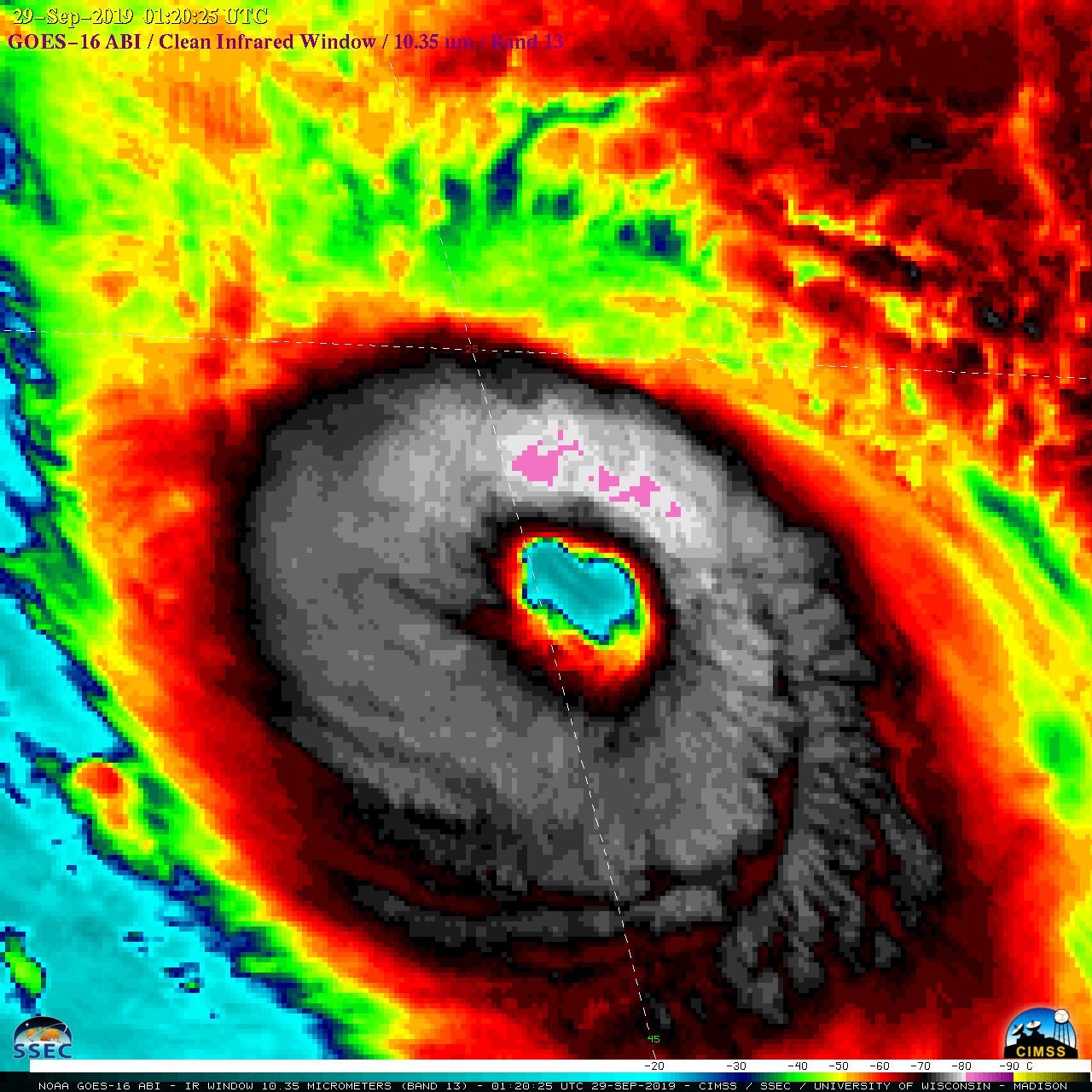
CIMSS Satellite Blog Updates: The Cooperative Institute for Meteorological Satellite Studies (CIMSS) Satellite Blog (https://cimss.ssec.wisc.edu/goes/blog/) was updated with the posts "Decker Fire in Colorado" (Oct. 2 and 3), "GOES-17 ABI Temperature Data Quality Flags (TDQF) thresholds updated" (Oct. 2), "Eruption of Popocatépetl in Mexico" (Oct. 2), "Fresh snow cover in Montana and Alberta" (Sep. 30 and Oct. 1), "Hurricane Lorenzo reaches Category 5 intensity" (Sep. 29) and "The probability of “intense convection” using geostationary satellite data" (Sep. 27). (S. Bachmeier, CIMSS, T. Schmit, E/RA2, J. Cintineo, CIMSS)
 (Click image to enlarge)
Figure: GOES-16 “Clean” Infrared Window (10.35 µm) image of Hurricane Lorenzo at 0120 UTC on September 29 2019, as the storm reached Category 5 intensity over the eastern Atlantic Ocean.
VISITORS:
NEXT WEEK:
LOOKING AHEAD:
| Archived Weeklies Page | Submit a report item |