[ Archive ]
| CIMSS-NOAA Weekly Report [ Archive ] |
ASPB AND CIMSS WEEKLY HIGHLIGHTS FOR THE WEEK ENDING JANUARY 10, 2020
IN THE PRESS:
SSEC and CIMSS Scientists in the News: Scientists at the University of Wisconsin-Madison (UW) Space Science and Engineering Center (SSEC) and the Cooperative Institute for Meteorological Satellite Studies (CIMSS) provide expert commentary, interviews, and imagery to news media and participate in events to promote science. In the news this week: 1) CIMSS scientist Scott Bachmeier talked with Wired Magazine about the dangerous occurrence of pyrocumulonimbus clouds over Australia: https://go.wisc.edu/873cz1. 2) The Weather Guys, Professors Steve Ackerman, CIMSS, and Jonathan Martin, UW-Madison Department of Atmospheric and Oceanic Sciences, looked back at the weather of 2019. The program aired on Wisconsin Public Radio: https://go.wisc.edu/6kz853. 3)CIMSS Satellite Blog contributor Scott Bachmeier published posts on the "Eruption of Popocatépetl in Mexico" (Jan. 9), and "Another outbreak of pyrocumulonimbus clouds in Australia" (Jan. 4, 6, 8). Read more at the CIMSS Satellite Blog: http://cimss.ssec.wisc.edu/goes/blog/. (Scott Bachmeier, CIMSS, Steve Ackerman, J. Phillips, SSEC)
 (Click image to enlarge)
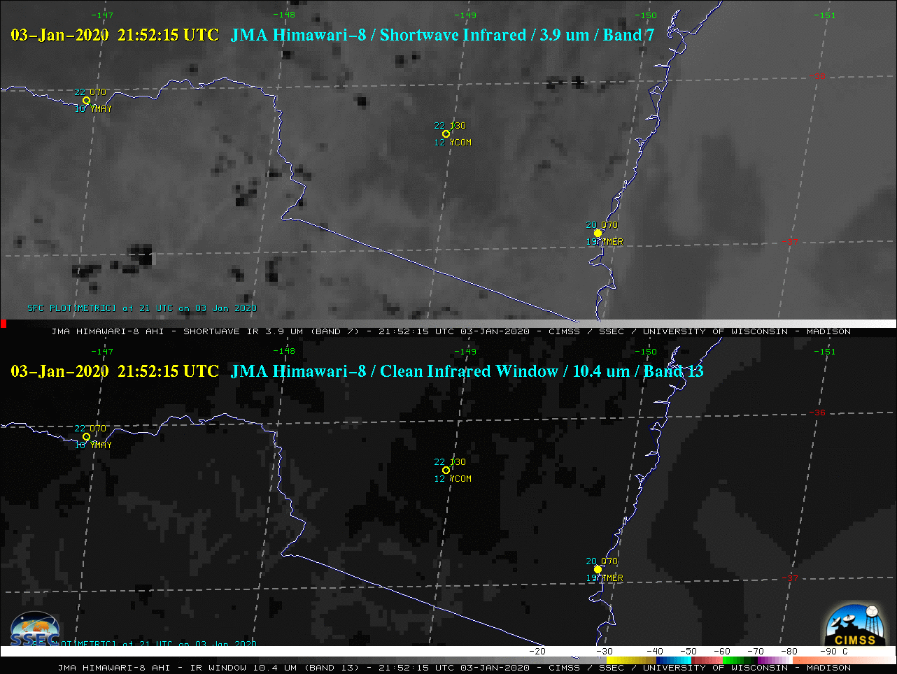
Figure: Himawari-8 Shortwave Infrared (3.9 µm) and “Clean” Infrared Window (10.4 µm) images on Jan. 4, 2020 showed the development of two pyroCb clouds over southern New South Wales, west of Cooma, and another near the border between Victoria and New South Wales. The second pyroCb exhibited cloud-top infrared brightness temperature values of -70ºC and colder (purple pixels). These images were picked up by Wired Magazine for their pyroCb story. Credit: CIMSS.
Gridded NUCAPS on CIMSS Satellite Blog: Scott Lindstrom, CIMSS, posted a training blog post on the CIMSS Satellite Blog on the use of horizontal thermodynamic fields derived from NOAA-Unique Combined Atmospheric Processing System (NUCAPS) profiles to estimate where a rain/snow line might occur. The fields were collected during a visit to the Sullivan WI National Weather Service Forecast Office (MKX). The blog post at https://cimss.ssec.wisc.edu/satellite-blog/archives/35383. (S. Lindstrom, CIMSS, 608 263 4425)
 (Click image to enlarge)
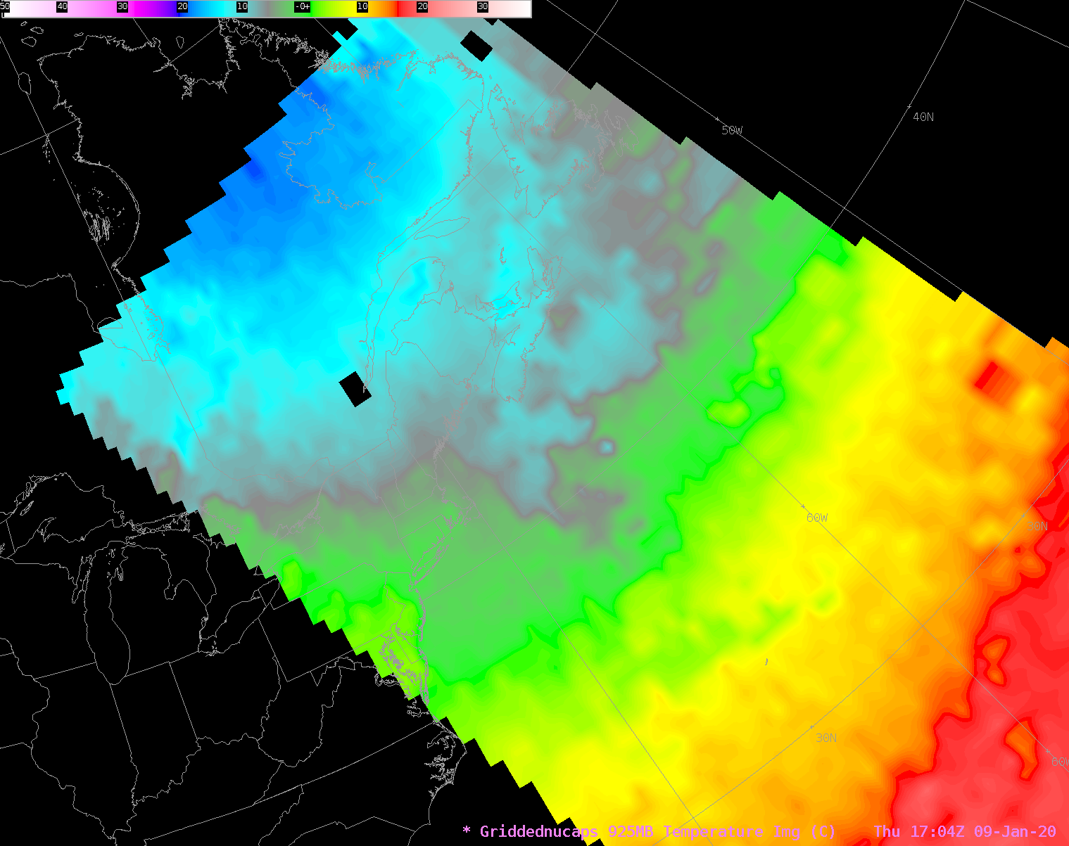
Figure: 925-hPa temperature field, derived from NUCAPS data, 1704 UTC on 9 January 2020.
ITEMS FOR THE ADMINISTRATOR:
ITEMS FOR THE ASSISTANT ADMINISTRATOR:
ITEMS FOR THE OFFICE DIRECTOR, STAR:
Paper on Microwave-based Global Snowfall Mapping Published: A new satellite remote sensing surface snowfall rate algorithm is described in a recently published paper titled "Retrieving surface snowfall with the GPM Microwave Imager: A new module for the SLALOM algorithm" (Rysman, J.-F., G. Panegrossi, P. Sano, A. C. Marra, S. Dietrich, L. Milani, M. S. Kulie, D. Casella, A. Camplani, C. Claud, and L. Edel, 2019, Geophysical Research Letters, 46:22, 13593-13601, doi:10.1029/2019GL084576). This algorithm uses co-located Global Precipitation Measurement (GPM) Microwave Imager and CloudSat Cloud Profiling Radar observations for tuning purposes, with CloudSat providing surface snowfall rate estimates. Multiple case studies are presented to illustrate algorithm efficacy under different conditions. Near-global snowfall mapping capabilities are also demonstrated. (M. Kulie, E/RA2, 608-263-6583, mark.kulie@noaa.gov)
 (Click image to enlarge)
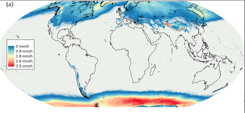
Figure: Unconditional surface snowfall rates between 70N-70S as estimated by the SLALOM algorithm.
New Manuscript on Lake-Effect Snow Events: A new manuscript is out this week in the January 2020 issue of the American Meteorological Society Journal of Applied Meteorology and Climatology titled "A Composite Analysis of Snowfall Modes from Four Winter Seasons in Marquette, Michigan". This work examines the microphysical and environmental characteristics of deep, synoptically-forced versus shallow, lake/surface-forced snow events. The lead author on this work is Claire Pettersen (SSEC/CIMSS) and co-authors include: Mark Kulie (NOAA/NESDIS/STAR), Aronne Merrelli (SSEC/CIMSS), Tim Wagner (SSEC/CIMSS), and Norman Wood (SSEC/CIMSS). The manuscript is available at https://journals.ametsoc.org/doi/10.1175/JAMC-D-19-0099.1. (C. Pettersen, SSEC, 608-772-6270, M. Kulie, E/RA2, 608-263-6583, mark.kulie@noaa.gov)
 (Click image to enlarge)
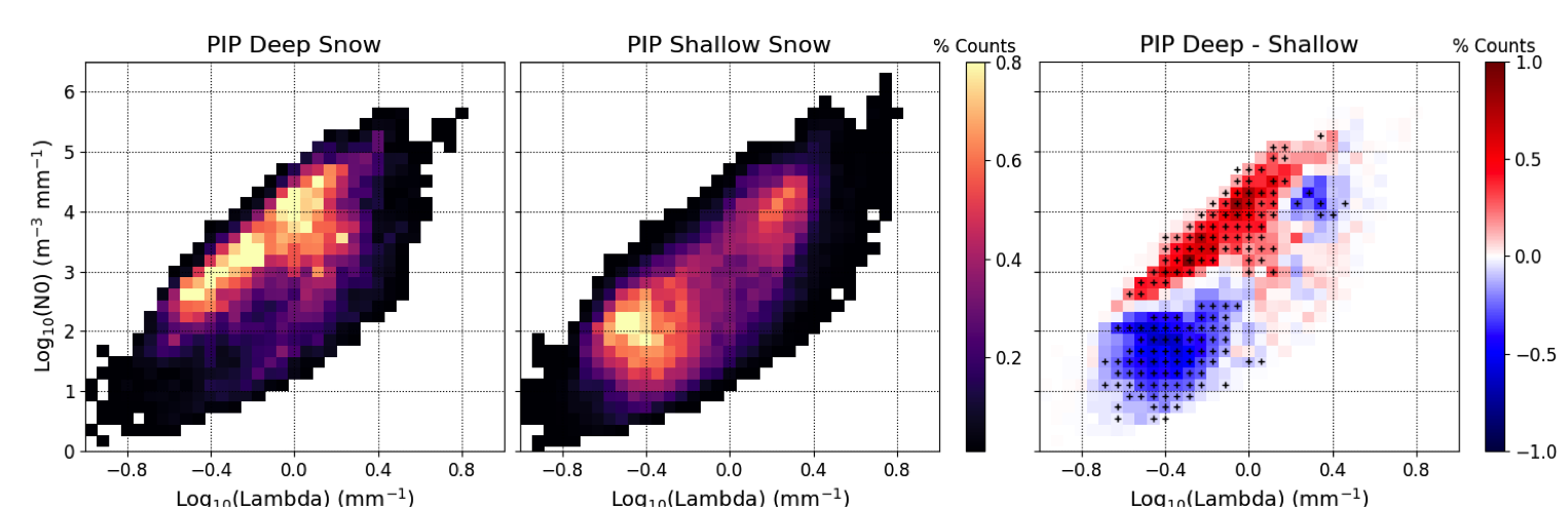
Figure: Composite two-dimensional histograms of PIP observations for (left) deep and (center) shallow snow events, along with (right) the difference of the event types, with red indicating more instances for the deep snow events and blue indicating more instances of shallow events. The black crosses in the right panel indicate where the differences between the deep and shallow snow are significant to 95%.
ITEMS FOR THE DIVISION CHIEF, CoRP:
Presentation to the EPA Region-1 Tribal Environmental Conference: Jim Kossin gave an invited presentation on January 8 to the New England Tribes (sponsored by the Mohegan Tribe and the EPA Region-1 Indian Program Manager). The talk was entitled “The Natural Hurricane Barrier Along the U.S. Southeast Coast, Past and Future.” (Jim Kossin, NCEI, 608-265-5356)
CIMSS Scientists visit NWS Office in Sullivan WI: Scott Lindstrom from the Cooperative Institute for Meteorological Satellite Studies (CIMSS) and Tim Schmit from the NESDIS STAR Advanced Satellite Products Branch (ASPB) visited the National Weather Service (NWS) Milwaukee/Sullivan office (MKX) on January 9, 2020, to provide on-site satellite training to three forecasters that are recent additions the MKX office, including Meteorologist-in-Charge (MIC) Kevin Lynott. Topics of discussion included Geostationary Operational Environmental Satellite R-Series (GOES-R) imagery, band differences, red-green-blue composites and quantitative products. Also covered were a number of satellite products from the Joint Polar Satellite System (JPSS), including NOAA-Unique Combined Atmospheric Processing System (NUCAPS) retrievals. Web applications that facilitate a better understanding of water vapor weighting functions and parallax were also demonstrated (they can be found off the link of links website: https://cimss.ssec.wisc.edu/goes/goesdata.html). (S. Lindstrom, CIMSS; T. Schmit, E/RA2, 608-263-0291)
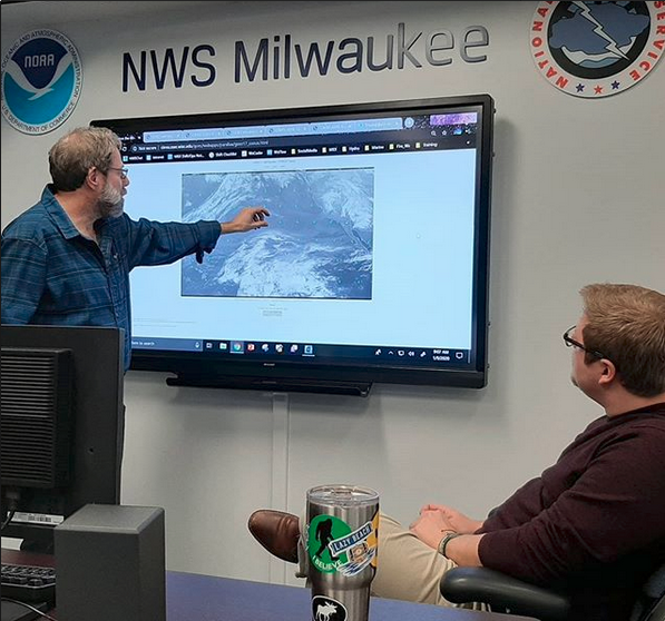 (Click image to enlarge)
Figure: Tim Schmit, NOAA/ASPB, demonstrated parallax at the National Weather Service Sullivan Office.
VISITORS:
NEXT WEEK:
LOOKING AHEAD:
| Archived Weeklies Page | Submit a report item |