[ Archive ]
| CIMSS-NOAA Weekly Report [ Archive ] |
ASPB AND CIMSS WEEKLY HIGHLIGHTS FOR THE WEEK ENDING FEBRUARY 7, 2020
IN THE PRESS:
SSEC and CIMSS Scientists in the News: Scientists at the University of Wisconsin-Madison (UW) Space Science and Engineering Center (SSEC) and the Cooperative Institute for Meteorological Satellite Studies (CIMSS) provide expert commentary, interviews, and imagery to news media and participate in events to promote science. In the news this week: 1) SSEC scientist Claire Pettersen and colleagues are studying the differences between lake effect and synoptic snowstorms that impact the Lake Superior region. SSEC News published this story: https://www.ssec.wisc.edu/news/articles/12497/. 2) CIMSS Satellite Blog contributor Scott Bachmeier published posts on "Severe turbulence over Arizona and New Mexico" (Feb. 3) and "Pyrocumulonimbus clouds in Australia: (Feb. 1). Read more at the CIMSS Satellite Blog (https://cimss.ssec.wisc.edu/satellite-blog/). 3) CIMSS Honorary Fellow Jordan Gerth was interviewed by The New York Times about OneWeb's plan to launch a constellation of Internet satellites and their potential to interfere with telescopes on Earth that use nearby frequencies: https://www.nytimes.com/2020/02/06/science/oneweb-launch.html. (C. Pettersen, SSEC, S. Bachmeier, CIMSS, J. Gerth, CIMSS, J. Phillips, SSEC, 608-262-8164)
 (Click image to enlarge)
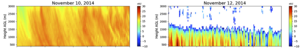
Figure: Graphic showing the average elevation of measured precipitation in the two different storm systems. Lake-effect systems (right) are between 1.5km – 2km, whereas the larger synoptic storms (left) extend beyond 3km.(C. Pettersen, 2020, JCAM). Credit: C. Pettersen, SSEC.
 (Click image to enlarge)
Figure: On Feb. 1, 2020, 2.5-miute rapid scan imagery from JMA Himawari-8 in the visible, shortwave infrared, and infrared window showed two small, pyrocumulonimbus (pyroCb) clouds spawned by large, hot bush fires in southern New South Wales, Australia. Credit; CIMSS.
ITEMS FOR THE ADMINISTRATOR:
ITEMS FOR THE ASSISTANT ADMINISTRATOR:
ITEMS FOR THE OFFICE DIRECTOR, STAR:
Book Chapter on Arctic Climate Change: Jeff Key co-authored a chapter on Arctic climate change in the recently-published book Physics and Chemistry of the Arctic Atmosphere (Koenigk, T. J. Key, and T. Vihma, 2020, Climate Change in the Arctic. In A. Kokhanovsky and C. Tomasi (eds.), Physics and Chemistry of the Arctic Atmosphere, Springer Polar Sciences. Springer, Cham. 717 pp., ISBN 978-3-030-33565-6, doi: https://doi.org/10.1007/978-3-030-33566-3_11). The chapter details changes in Arctic climate that are a result of complex interactions between the cryosphere and atmosphere, and discusses processes that contribute to the amplified warming signal such as the ice albedo feedback, changes in clouds and water vapour, enhanced meridional energy transport in the atmosphere and in the ocean, vertical mixing in Arctic winter inversions, and temperature feedbacks. Much of the Arctic satellite climatology work done at the Cooperative Institute for Meteorological Satellite Studies (Y. Liu, A. Letterly, X. Wang, J. Key) was represented in the chapter. (J. Key, E/RA2, 608-263-2605, jeff.key@noaa.gov)
 (Click image to enlarge)
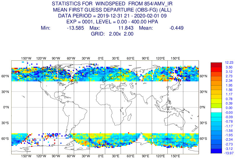
Leo-Geo Winds Monitored at ECMWF: The "leo-geo" polar wind product that is generated in near real-time at the Cooperative Institute for Meteorological Satellite Studies (CIMSS) is being monitored in the European Centre for Medium-Range Weather Forecasts (ECMWF) Integrated Forecasting System (IFS) as of late 2019. Real-time monitoring statistics and graphs can be found at this ECMWF webpage for these and other satellite-derived winds: http://bit.ly/376Lg8Y. The leo-geo wind product combines data from geostationary and polar-orbiting satellites to form Arctic and Antarctic composites from which winds are derived. (D. Santek, CIMSS, 608-263-7410; B. Hoover, SSEC; M. Lazzara, SSEC; J. Key, E/RA2, 608-263-2605, jkey@ssec.wisc.edu)
 (Click image to enlarge)
Figure: An example plot depicting the leo-geo upper-level wind speed departure from the ECMWF model background. The bias (mean departure) is low at -0.45 m/s.
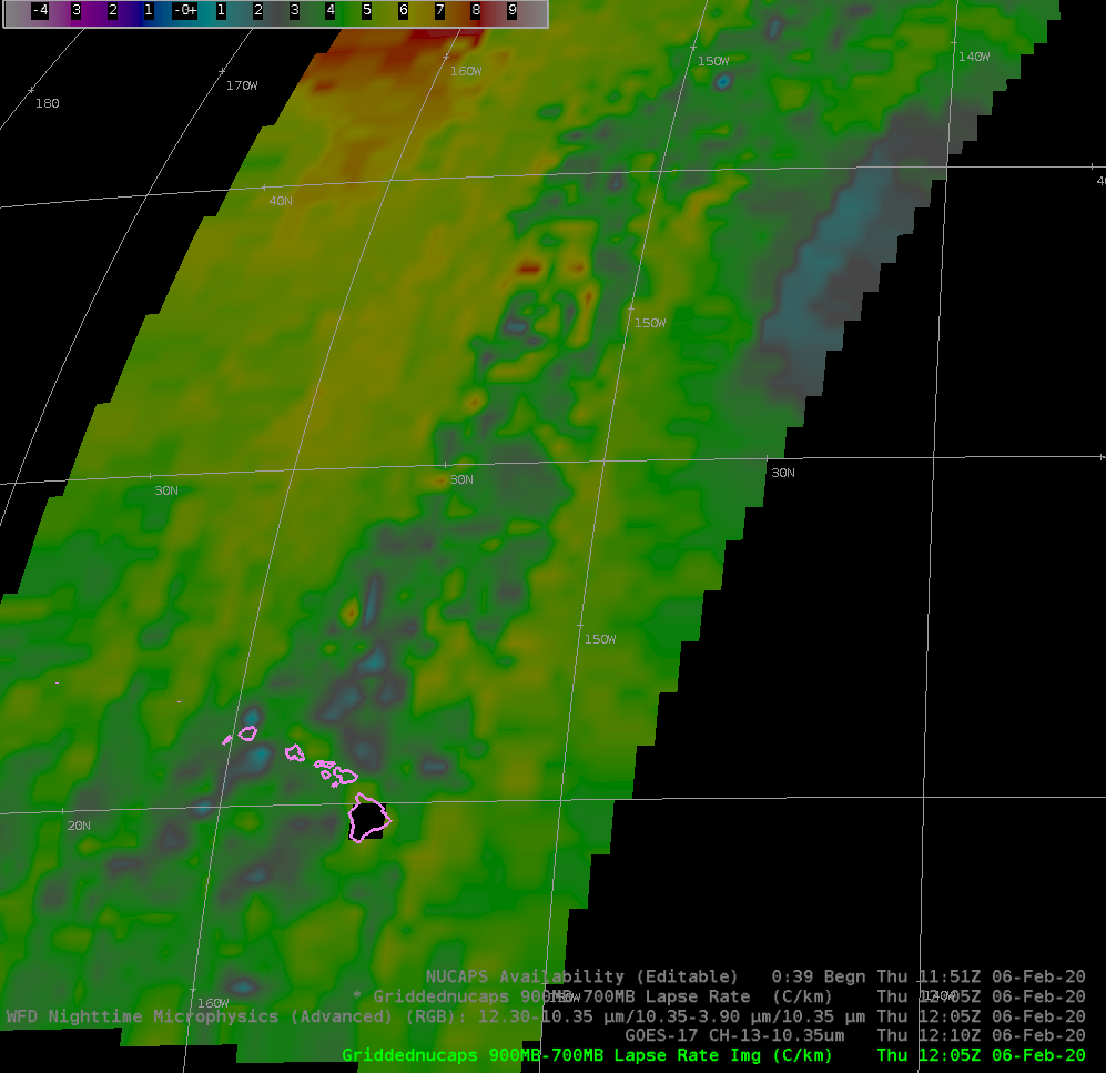
CIMSS Activities with NUCAPS Training: Scott Lindstrom of the Cooperative Institute for Meteorological Satellite Studies (CIMSS) published a new Training Video on YouTube (https://www.youtube.com/watch?v=1s69sHc2hXU) on NOAA-Unique Combined Atmospheric Processing System (NUCAPS) vertical profiles and how they can be accessed in AWIPS. Included in this training is information on Gridded NUCAPS. As a followup, Scott created a Blog Post on the CIMSS Satellite Blog (https://cimss.ssec.wisc.edu/satellite-blog/archives/35550) showing Gridded NUCAPS values of low-level (900-700 mb) lapse rates over the Pacific Ocean on either side of a cold front. (Scott Lindstrom, CIMSS, 608 263 4425)
 (Click image to enlarge)
Figure: Gridded NUCAPS values of 900-700 mb Lapse Rate at 1205 UTC on 6 February 2020 over the north Pacific Ocean.
ITEMS FOR THE DIVISION CHIEF, CoRP:
VISIT TROWAL Training for the NWS Riverton Wyoming Forecast Office: Scott Lindstrom from the Cooperative Institute for Meteorological Satellite Studies (CIMSS) provided Virtual Institute for Satellite Integration Training (VISIT) instruction to the Riverton, Wyoming forecast office of the National Weather Service (NWS/RIW) on Troughs of Warm Air Aloft (TROWALs), features associated with occluded extratropical cyclones. The live training used VISITview software and lasted 20 minutes; it was followed by a Q&A session. (S. Lindstrom, CIMSS, 608 263 4425)
VISITORS:
NEXT WEEK:
LOOKING AHEAD:
| Archived Weeklies Page | Submit a report item |