[ Archive ]
| CIMSS-NOAA Weekly Report [ Archive ] |
ASPB AND CIMSS WEEKLY HIGHLIGHTS FOR THE WEEK ENDING FEBRUARY 28, 2020
IN THE PRESS:
SSEC and CIMSS Scientists in the News: SSEC and CIMSS Scientists in the News: Scientists at the University of Wisconsin-Madison (UW) Space Science and Engineering Center (SSEC) and the Cooperative Institute for Meteorological Satellite Studies (CIMSS) provide expert commentary, interviews, and imagery to news media and participate in events to promote science. In the news this week: 1) CIMSS scientist Scott Lindstrom and colleagues have provided a product to assess ice concentration over the Great Lakes that is based on the MIRS sea ice product. SSEC News published this story: https://www.ssec.wisc.edu/news/articles/12534/. 2) CIMSS Satellite Blog contributors Scott Bachmeier and Scott Lindstrom published posts on the "Tehuano gap wind event" (Feb. 27), "Comparing Gridded NUCAPS data to model fields" (Feb.24), "Blowing dust across the Canary Islands and Atlantic Ocean" (Feb. 23-24), and "Global True-Color Visible Imagery Animated" (Feb. 21), and "Gridded NUCAPS over the southeast United States" (Feb. 21). Read more at the CIMSS Satellite Blog (https://cimss.ssec.wisc.edu/satellite-blog/). (S. Lindstrom, CIMSS, E. Verbeten, SSEC, S. Bachmeier, CIMSS, J. Phillips, SSEC, 608-262-8164)
 (Click image to enlarge)
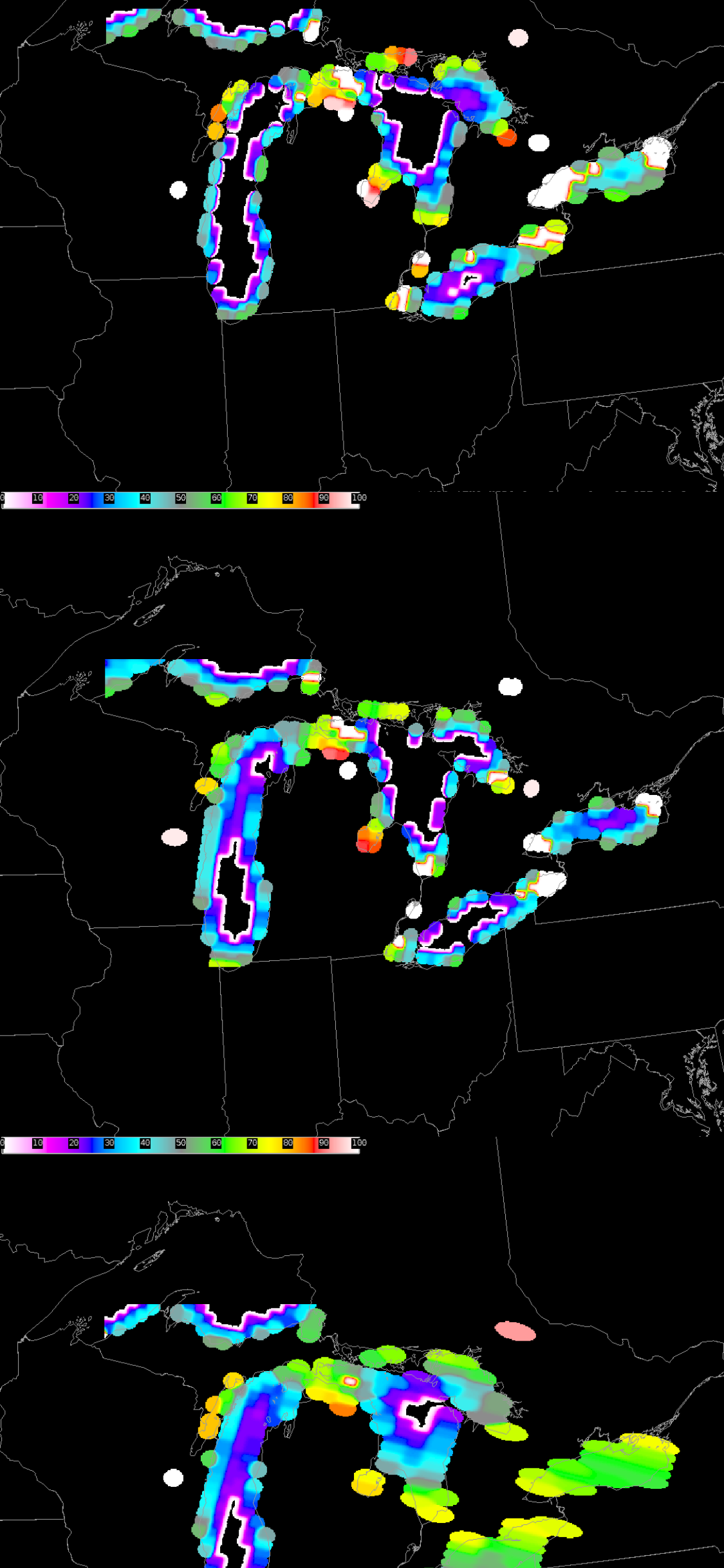
Figure: A visualization of the NOAA-20 microwave data (as a percentage) used to track ice cover over the Great Lakes. Credit: Scott Lindstrom.
 (Click image to enlarge)
Figure: GOES-16 dust, RGB images from 0800 UTC on 22 Feb. to 2100 UTC on 23 Feb. provided a continuous day/night visualization of a dust plume across the Canary Islands. A second dust plume emerges from below a patch of mid/high-altitude clouds on Feb. 23. Credit: SSEC, CIMSS, Geo2Grid.
ITEMS FOR THE ADMINISTRATOR:
ITEMS FOR THE ASSISTANT ADMINISTRATOR:
ITEMS FOR THE OFFICE DIRECTOR, STAR:
CIMSS and ASPB Participation in JPSS/GOES-R Summit: The Cooperative Institute for Meteorological Satellite Studies (CIMSS), Space Science and Engineering Center (SSEC), and the STAR Advanced Satellite Products Branch (ASPB) participated extensively in the JPSS/GOES-R Proving Ground/Risk Reduction Summit in College Park, MD, 24-18 February 2020. Brad Pierce, Andy Heidinger, Mike Pavolonis, Tim Schmit, Tony Wimmers, and Jeff Key participated on panels. Jun Li, Heidinger, and Pavolonis gave oral presentations in the Special Topics session. Yinghui Liu, Joe Taylor, Rich Dworak, Aaron Letterly, and others presented posters and participated in splinter sessions. William Straka received an JPSS Innovation Award for his contribution to the river flood products. Details are available at https://www.star.nesdis.noaa.gov/star/meeting_2020JPSSGOES.php. (J. Key, E/RA2, 608-263-2605, jeff.key@noaa.gov)
 (Click image to enlarge)
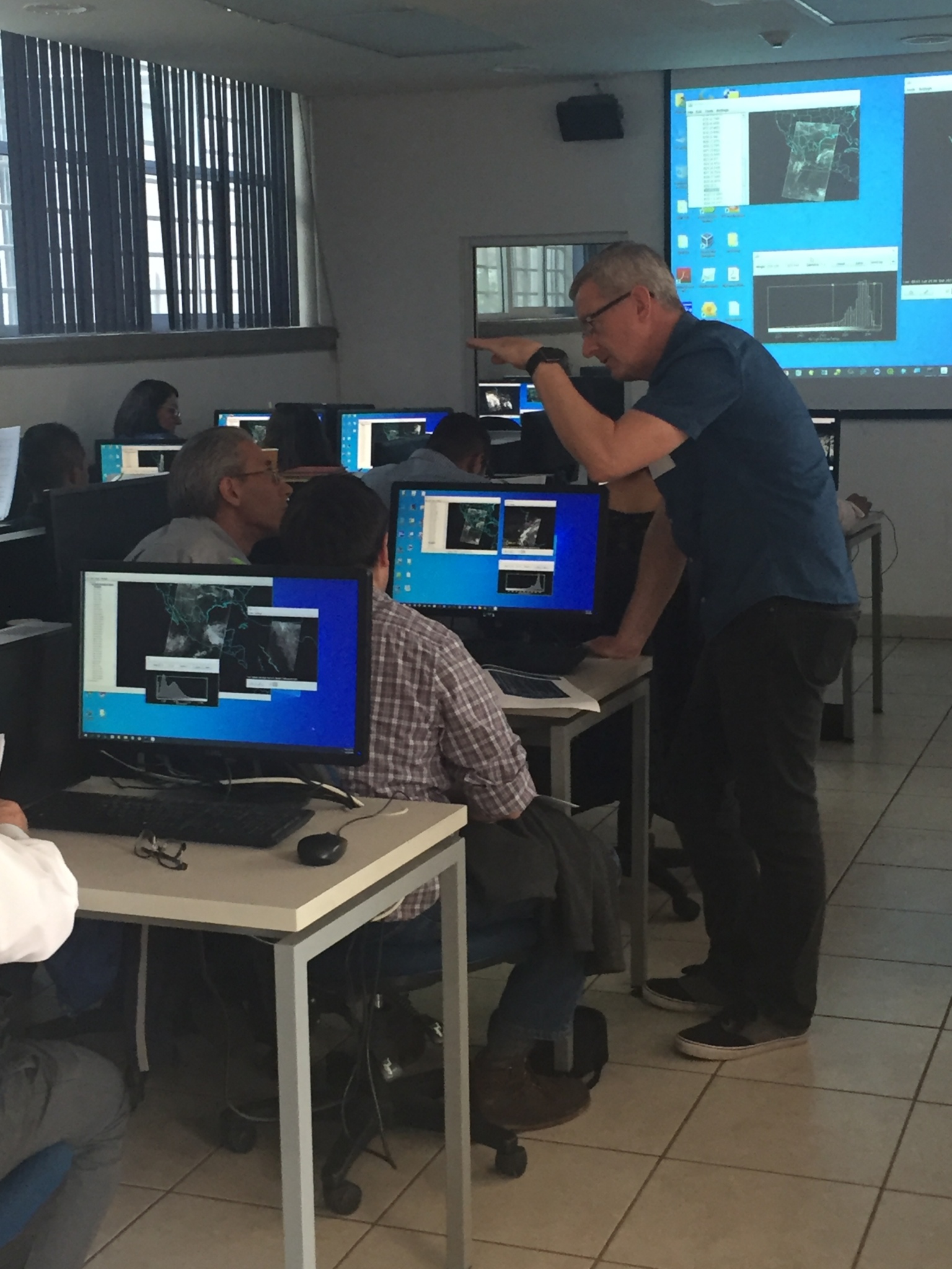
Mexico City Direct Broadcast Applications Workshop: Relationships built from the Community Satellite Processing Package (CSPP) Users' Group Conference held in China in June, 2019, resulted in a CSPP Direct Broadcast Applications workshop taught in partnership with the Laboratorio Nacional de Observación de la Tierra (LANOT), Universidad Nacional Autónoma de México (UNAM) in Mexico City, 18-21 February, 2020. The goal of the workshop was to present the broad range of products available from Polar Orbiter and Geostationary Meteorological Satellite CSPP software, as well as the scientific basis of the products and their applications. Twenty five students attended the workshop and presented results of an investigation of their choice on the last day, using direct broadcast data. Graduate students, researchers, Navy personnel, the weather service and forest service personnel were among the attendees. We hope this will initiate further collaborations between CIMSS and LANOT in the future. (K. Strabala, CIMSS, 608-263-8752, L. Gumley, CIMSS, J. Braun, CIMSS, A. Huang, CIMSS, G. Martin, CIMSS)
 (Click image to enlarge)
Figure: Liam Gumley works with students during an investigation of a Visible Infrared Imaging Radiometer Suite (VIIRS) direct broadcast data set. The HYDRA analysis toolkit is one of the software packages distributed as part of the CSPP Low Earth Orbiter (LEO) software suite.
ITEMS FOR THE DIVISION CHIEF, CoRP:
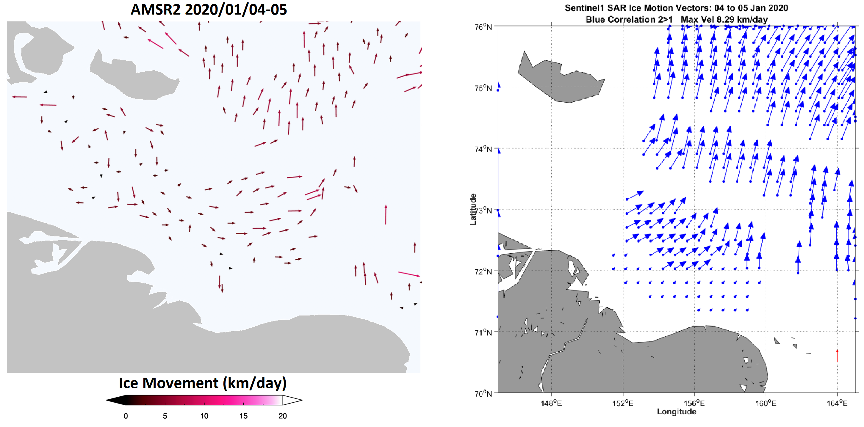
SAR Ice Motion Updates and Agreement with VIIRS Products: Individual Visible Infrared Imaging Radiometer Suite (VIIRS) and Advanced Microwave Scanning Radiometer 2 (AMSR2) sea ice motion products have been developed and are running routinely at theCooperative Institute for Meteorological Satellite Studies (CIMSS). One goal of the JPSS Risk Reduction ice motion project is to produce a blended product that combines ice motion information from VIIRS, AMSR2, and Synthetic Aperture Radar (SAR) data. Since early January, ice motion vectors using SAR data are being produced on a 500-m grid. Over 400 Sentinel-1 SAR images are acquired and processed each day to cover 75% of the Arctic above 71°N in a processing routine developed by NOAA affiliate researcher Chris Jackson. Compositing the ice motion vectors over the Arctic area results in a motion field that has compared well to AMSR2 and VIIRS ice motion in initial tests. SAR ice motion data at intra-day time scales on similar grids to the AMSR2 and VIIRS ice motion products is being produced for a more robust comparison for the later winter of 2020. The attached image shows AMSR2 ice motion compared to SAR motion for a 24-hour period in early January. Over the domain of Siberian shoreline and the New Siberian Islands, both sets of output show motion to the northeast immediately off the shoreline and a motion field shifting to the north further away from shore. The relative magnitude of the ice movement is also similar from both sensors. Initial agreement between the lowest- (AMSR2) and highest-resolution (SAR) is an excellent step towards creating daily blended products that leverage the unique spatial coverage, observation density, and capabilities of the three sensors. (A. Letterly, CIMSS, 608-890-1981)
 (Click image to enlarge)
Figure: 24-hour ice motion fields near the New Siberian Islands during January 5, 2020. Output from AMSR2 (left) shows spatially-averaged motion compared to SAR motion (right) which shows Fast Fourier Transform-derived ice motion over large grid boxes. Both images show that ice east of the New Siberian Islands was moving poleward 8-10km/day.
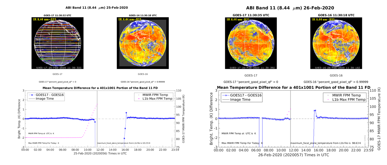
Modified GOES-17 ABI Mode 3 Cooling Timeline Implementation has been Verified: The Geostationary Operational Environmental Satellite (GOES)-R Algorithm Working Group (AWG) Imagery Team verified the impacts of the recent (February 26, 2020) GOES-17 ABI Mode 3 Cooling Timeline Implementation. By reducing the number of images scanned over part of the day over the four periods of peak heating throughout the year, the ABI focal plane module temperatures can be reduced. This results in approximately an extra hour of good imagery on either side of the heating for some spectral bands, most notably the water vapor bands. These results were presented to the Calibration Working Group. More can be found at http://cimss.ssec.wisc.edu/goes-r/abi-/16band_mainmenu.html and https://www.ospo.noaa.gov/data/messages/2020/MSG055214403.html. (T. Schmit, E/RA2, 608-263-0291, tim.j.schmit@noaa.gov, M. Gunshor, CIMSS)
 (Click image to enlarge)
Figure: Image shows positive impact of the GOES-17 Mode 3 Cooling Timeline implementation on February 26, 2020. Before (Left, February 25) at 11:30 UTC Band 11 (8.44 micrometer) GOES-17 image is unusable, but after (Right, February 26) at the same time the band 11 GOES-17 imagery still looks reasonable and comparison to GOES-16 (bottom panels) is much improved. Images from http://cimss.ssec.wisc.edu/goes-r/abi-/band_statistics_imagery.html.
VISITORS:
NEXT WEEK:
LOOKING AHEAD:
| Archived Weeklies Page | Submit a report item |