[ Archive ]
| CIMSS-NOAA Weekly Report [ Archive ] |
ASPB AND CIMSS WEEKLY HIGHLIGHTS FOR THE WEEK ENDING MARCH 6, 2020
PRODUCTS AND APPLICATIONS:
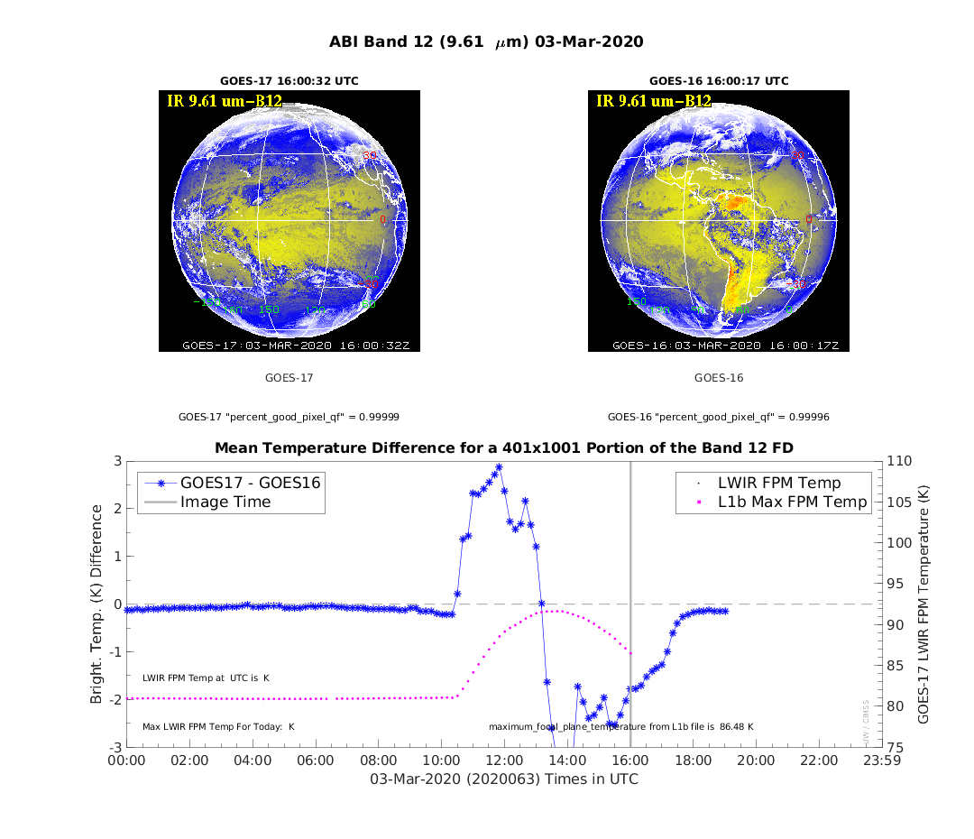
CIMSS Detects ABI Imagery Anomalies: Scientists at the Cooperative Institute for Meteorological Satellite Studies (CIMSS) notified NOAA's Office of Satellite and Product Operations (OSPO) of multiple anomalies in the Advanced Baseline Imager (ABI) data on both Geostationary Operational Environmental Satellite (GOES)-16 and GOES-17 this week. The anomalies were reported to the Product Readiness and operations (PRO) team and GOES-R Calibration Working Group (CWG). Two imagery quality issues were detected March 3, using data quality monitoring tools developed by the GOES-R Algorithm Working Group (AWG) Imagery Team at CIMSS in Madison, Wisconsin (http://cimss.ssec.wisc.edu/goes-r/abi-/band_statistics_imagery.html). One issue was GOES-16 ABI band 8 striping due to "erratic" behavior in one detector and the other issue was that the Predictive Calibration component of the GOES-17 calibration was inadvertently turned off, causing large temperature biases greater than 1 K in most IR bands; both issues were subsequently fixed by the satellite operators. (T. Schmit, E/RA2, 608-263-0291, tim.j.schmit@noaa.gov; M. Gunshor, CIMSS)
 (Click image to enlarge)
Figure: An example from the CIMSS monitoring tool showing the co-located GOES-16 & -17 brightness temperature difference for ABI band 12 on March 3, 2020, showing larger than normal differences, which are consistent with no Predictive Calibration being applied.
Moderate Assurance Distribution of Fog/Low Stratus Products: National Weather Service (NWS) users have long relied on quantitative Geostationary Operational Environmental Satellite (GOES) based fog/low stratus products for aviation decision support and other key nowcasting applications. Since 2011, these products have been available in Advanced Weather Interactive Processing System (AWIPS) via a moderate assurance production system hosted by the Cooperative Institute for Meteorological Satellite Studies (CIMSS) on a best effort basis. With GOES-15 no longer supplementing GOES-17 in the GOES-West position, the moderate assurance system was updated to provide a GOES-17 version of the products in lieu of GOES-15 (in addition to the GOES-16 version). The GOES-17 version of the multi-data source algorithm includes mitigation measures for offsetting impacts of the GOES-17 Advanced Baseline Imager (ABI) loop heat pipe issue. While taking much longer than initially planned, it is anticipated that the GOES-16 version of the fog/low stratus products will become operational in NESDIS by June 2020. The GOES-17 version of the products will likely not become operational until sometime in 2021, thereby making the moderate assurance capability critical for bridging the significant time gap associated with current research-to-operations system engineering practices. For additional information and examples see https://cimss.ssec.wisc.edu/satellite-blog/archives/35895 and https://fusedfog.ssec.wisc.edu/?p=4242. (M. Pavolonis, E/RA2, 608-263-9597, Mike.Pavolonis@noaa.gov, C. Calvert, CIMSS, S. Lindstrom, CIMSS)
WORKSHOPS, CONFERENCES, AND MEETINGS:
ASPB Participation in the NOAA Regional Collaboration Network Workshop: The STAR Advanced Satellite Products Branch (ASPB) was represented at the 2020 NOAA Regional Collaboration Network (RCN) Workshop held at the NOAA Western Regional Center in Seattle, WA from 24-28 February 2020. Mark Kulie (ASPB) attended the workshop as a member of the NOAA Great Lakes Regional Collaboration Team delegation that was comprised of representatives from three Great Lakes region NOAA line offices. Workshop attendees learned about innovative collaborative projects in the NOAA Western Region, toured the NOAA Western Regional Center and learned about novel instrument development activities performed at the center, received training to foster more effective RCN collaborations, and developed specific strategies to improve GLRCT functionality based on workshop lessons. ( M. Kulie, E/RA2, 608-263-6583, mark.kulie@noaa.gov)
CIMSS Participation in the CRTM Workshop and Training Session: The Joint Center for Satellite Data Assimilation (JCSDA) sponsored a workshop and training session in Monterey, CA, 28 February 2020, for users and developers of the Community Radiative Transfer Model (CRTM) to assist primarily JCSDA partners in the use of the CRTM for data assimilation and other applications. Participants were from academic institutions, the U.S. Naval Research Laboratory (NRL), the National Center for Atmospheric Research (NCAR), and NASA. Tom Greenwald of the Cooperative Institute for Meteorological Satellite Studies (CIMSS) served as an instructor for the microwave radiative transfer tutorial. (T. Greenwald, CIMSS, 608-263-3629).
 (Click image to enlarge)
Participation in PMEL Five-year Review: Jeff Key participated remotely as a stakeholder in the NOAA Pacific Marine Environmental Laboratory five-year review. The review was held at the NOAA Western Regional Center in Seattle, WA, March 3-5, 2020. Four research themes were covered: Climate-Weather, Ocean and Coastal Processes, Marine Ecosystems, and Innovation and Development. Key was part of the Climate-Weather Research Theme stakeholder group. More information on the review is available at https://www.pmel.noaa.gov/2020-lab-review. (J. Key, E/RA2, 608-263-2605, jeff.key@noaa.gov)
TRAINING AND EDUCATION:
Weekly Colloquium at University of Arizona in Tucson: On 6 March 2020 P. Menzel presented a talk on “Taking pictures of clouds from space – a perspective on the advent and evolution of satellite observations" as part of the weekly colloquium series in the Department of Hydrology and Atmospheric Sciences at the University of Arizona. Approximately 60 faculty and graduate students heard about the rocket and satellite events from the last 70 years that contributed to characterizing clouds and their changes during storm events, annual seasonal cycles, and the passage of several decades. Discussions with Professor Xubin Zeng suggested some possible opportunities for future collaborations. (P. Menzel, CIMSS, 608-263-4930, paulm@ssec.wisc.edu)
MEDIA AND OUTREACH:
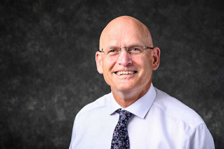
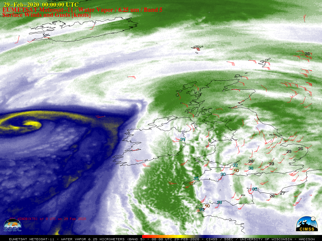
SSEC and CIMSS Scientists in the News: SSEC and CIMSS Scientists in the News: Scientists at the University of Wisconsin-Madison (UW) Space Science and Engineering Center (SSEC) and the Cooperative Institute for Meteorological Satellite Studies (CIMSS) provide expert commentary, interviews, and imagery to news media and participate in events to promote science. In the news this week: 1) UW-Madison announced this week that Steve Ackerman will serve as the university's next vice chancellor for research and graduate education. Ackerman is a faculty member in the Department of Atmospheric and Oceanic Sciences who served for 18 years as as director of CIMSS, as well as interim director for SSEC. (https://news.wisc.edu/ackerman-to-lead-uw-madisons-research-and-graduate-education/) 2) CIMSS scientist Jason Otkin was interviewed by Wired on the flash drought phenomenon. (https://www.wired.com/story/flash-droughts/) 3) CIMSS Satellite Blog contributors Scott Bachmeier and Scott Lindstrom published posts on the "Rapidly intensifying storm in the North Pacific Ocean" (Mar. 4-5), "GOES-17 IFR Probability Fields are now available via LDM Feed (Mar. 3), "Strong Tornado through Nashville Tennessee" (Mar.3), "GOES-15 is no longer sending data" (Mar. 2), and "Storm Jorge impacts the British Isles" (Mar. 1). Read more at the CIMSS Satellite Blog (https://cimss.ssec.wisc.edu/satellite-blog/). (S. Ackerman, J. Otkin, CIMSS, S Bachmeier, CIMSS, S. Lindstrom, CIMSS, J. Phillips, SSEC, 608-262-8164)
 (Click image to enlarge)
Figure: UW-Madison Vice Chancellor for Research and Graduate Education Steve Ackerman. Credit: Jeff Miller, UW-Madison.
 (Click image to enlarge)
Figure: EUMETSAT Meteosat-11 water vapor images showed the large field of strong surface winds associated with Storm Jorge as it approached the British Isles Feb. 29 - Mar. 1, 2020, with wind gusts of 70 knots recorded in Ireland. Credit: CIMSS.
 (Click image to enlarge)
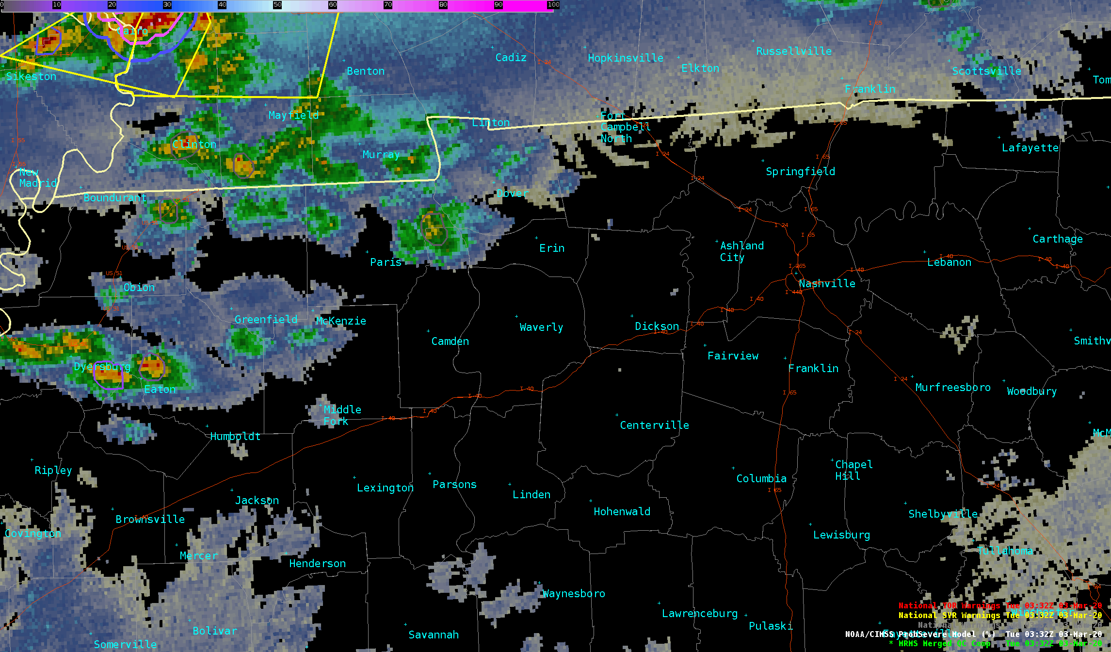
Figure: NOAA/CIMSS ProbSevere display captured the long storm over northwest to north-central Tennessee on 3 Mar. 2020, 0330 to 0730 UTC. Credit: NOAA, CIMSS.
| Archived Weeklies Page | Submit a report item |