[ Archive ]
| CIMSS-NOAA Weekly Report [ Archive ] |
ASPB AND CIMSS WEEKLY HIGHLIGHTS FOR THE WEEK ENDING MARCH 20, 2020
PRODUCTS AND APPLICATIONS:
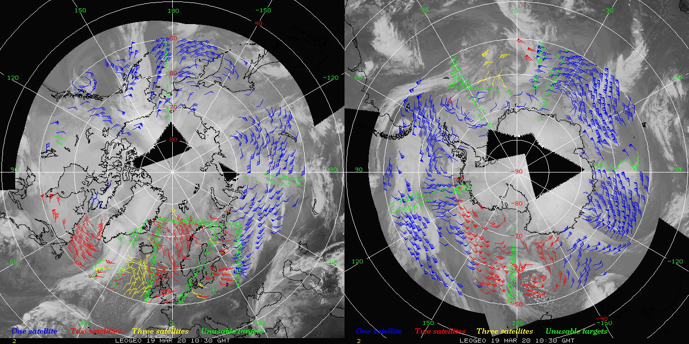
Leo-Geo Winds Updated to use GOES-16 and GOES-17: The "leo-geo" polar winds product that is generated in near real-time at the Cooperative Institute for Meteorological Satellite Studies (CIMSS) has been updated to include data from both GOES-16 and GOES-17. This wind product combines data from geostationary and polar-orbiting satellites to form Arctic and Antarctic composites from which winds are derived. With the improved temporal frequency of the GOES-R series satellites over the previous GOES satellites, a more complete coverage in the high latitudes is realized. The leo-geo winds product is assimilated in operational models at several locations, including the UK Met Office, the Naval Research Laboratory, and the National Center for Atmospheric Research. (D. Santek, CIMSS, 608-263-7410; B. Hoover, SSEC; M. Lazzara, SSEC; J. Key, E/RA2, 608-263-2605, jkey@ssec.wisc.edu)
 (Click image to enlarge)
Figure: An example of the leo-geo wind product overlaid on a composite satellite image from 19 March 2020. Wind barbs in blue are derived from a single satellite, red from two different satellites, and yellow from three different satellites. Green dots represent potential targets to track, however they are located on seams between different satellite data and are therefore unusable.
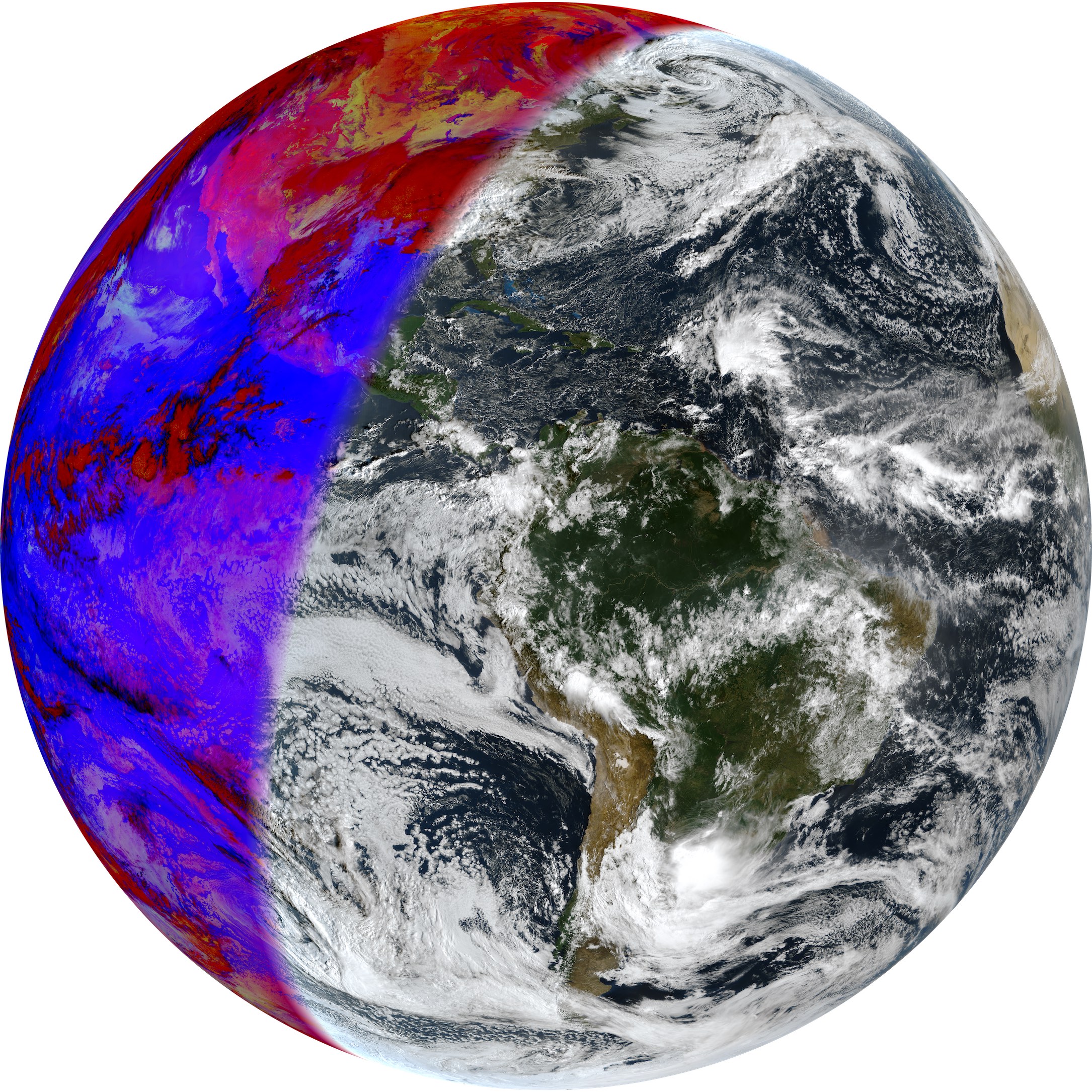
Geo2Grid Image Creation Software Package Update Released: The Community Satellite Processing Package (CSPP) for Geostationary Satellites (Geo) group at the Cooperative Institute for Meteorological Satellite Studies (CIMSS) released an update to the Geo2Grid software package, which provides an easy way to efficiently create high quality single band and combined Red/Green/Blue (RGB) images from geostationary satellite data. The software supports the Geostationary Operational Environmental Satellite (GOES)-16 and GOES-17 Advanced Baseline Imager (ABI) and the Himawari-8 Advanced Himawari Imager (AHI). Capabilities include 500m sharpening and Rayleigh correction as part of true color image creation, generation of GeoTiff and PNG files with optional map overlay, creation of animations, and regridding to user-defined projections. The v1.0.1 release includes significant performance improvements, additional AHI RGBs, improved day/night transition regions and several bug fixes resulting from user feedback. (G. Martin, CIMSS, 608-263-6794, D. Hoese, SSEC, K. Strabala, CIMSS)
 (Click image to enlarge)
Figure: Geo2Grid image of combined GOES-16 ABI true color (daytime) and night microphysics (nighttime) using observations from 12 November 2018, 12:30 UTC.
AWARDS AND RECOGNITION:
PUBLICATIONS:
Manuscript on combining passive and active remote sensing using machine learning for cloud-top height retrieval published: A manuscript titled "Retrieval of cloud top properties from advanced geostationary satellite imager measurements based on machine learning algorithms" has been published in Remote Sensing of Environment (Volume 239, 15 March 2020, 111616). This paper reports on a study to derive the cloud-top height (CTH) from combined passive advanced geostationary imager (Advanced Himawari Imager) and active Cloud-Aerosol Lidar and Infrared Pathfinder Satellite Observations (CALIPSO) using an advanced machine learning algorithm. It is found that significant CTH improvements from machine learning algorithm over the traditional physical-based 1DVAR algorithm for high and optically thin clouds, while 1DVAR has advantage on CTH retrieval for low clouds. Combining machine learning and 1DVAR algorithm provides the better CTH retrievals than either alone. The combined approach could be used to process data from advanced geostationary imagers for climate and weather applications. Co-authors are Min Min (CMA), Jun Li (CIMSS, the corresponding author), Fu Wang (CMA), Zijing Liu (CMA), and W. Paul Menzel (CIMSS). (Jun Li, CIMSS, 608-262-3755, Jun.Li@ssec.wisc.edu)
WORKSHOPS, CONFERENCES, AND MEETINGS:
GSICS Plenary Meeting: Andrew Heidinger attended the 2020 Global Spaced-based Inter-Calibration System (GSICS) Plenary Meeting held remotely this week. It was originally planned for Seoul, Korea. Heidinger presented on the status of the next generation of the International Satellite Cloud Climatology Project (ISCCP-NG). ISCCP-NG is a new cloud climatology based on the new era of advanced geostationary imagers. ISCCP-NG would like to leverage the work done by GSICS though it is not clear yet if all agencies will be able to provide GSICS corrections for all channels. GSICS would also benefit from this collaboration because ISCCP-NG would likely be the primary source of advanced geostationary imager data for a large set of users. Heidinger also attended the Visible/Near-Infrared meeting the following day and has been asked to chair a session at the next GSICS meeting in China. (A. Heidinger, E/RA2, 608-263-6757, andrew.heidinger@noaa.gov)
NOAA Snow Workshop: The NOAA Snow Workshop convened on 18-19 March 2020. The main goals of this workshop were to instigate discussions between the snow observation and research communities, identify high-priority NOAA products with unmet observational requirements, and identify existing capabilities and new technologies that could benefit operations in the near future. Mark Kulie (ASPB) presented an invited talk on ground-based observations of snow-to-liquid variability in the Upper Great Lakes and served as a panelist for the Observational Opportunities: Emerging Research and Technologies workshop session. (M. Kulie, E/RA2, 608-263-6583)
ACCP Sub-Orbital Working Group Workshop: The NASA Aerosol, Cloud, Convection, and Precipitation (ACCP) mission held a Sub-Orbital Working Group virtual workshop from 11-13 March 2020. This workshop was held to identify and prioritize sub-orbital observational needs for the proposed ACCP research satellite mission. Norm Wood (Cooperative Institute for Meteorological Satellite Studies, CIMSS), Claire Pettersen (CIMSS), and Mark Kulie (ASPB) were invited attendees for the ACCP Cold Clouds and Precipitation scientific objective group. Kulie served as the team lead for this group and chaired a workshop session dedicated to this topic. A follow-on meeting to formalize ideas generated from this meeting is tentatively scheduled for Fall 2020. (M. Kulie, E/RA2, 608-263-6583).
TRAINING AND EDUCATION:
MEDIA AND OUTREACH:
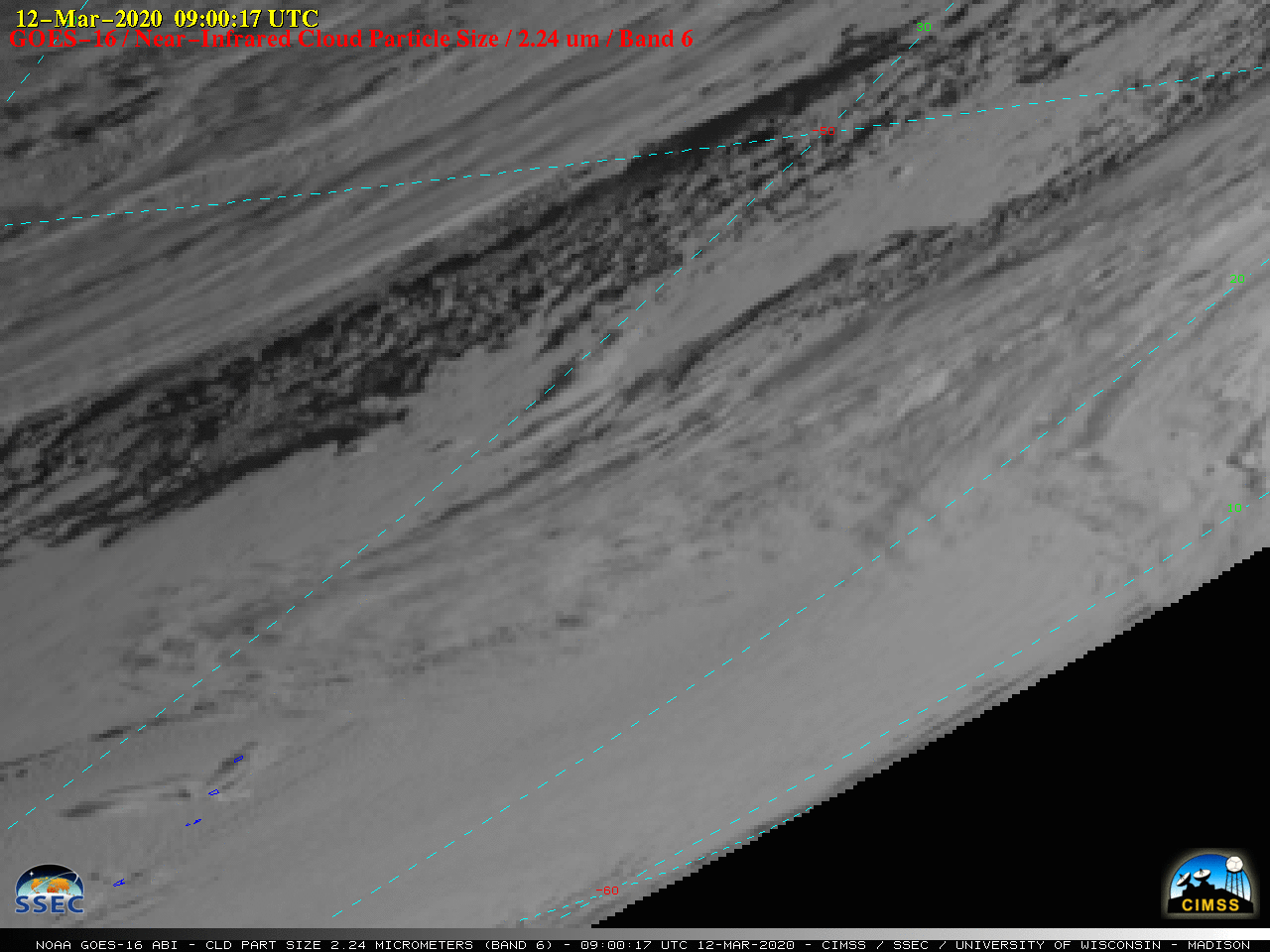
SSEC and CIMSS Scientists in the News: Scientists at the University of Wisconsin-Madison (UW) Space Science and Engineering Center (SSEC) and the Cooperative Institute for Meteorological Satellite Studies (CIMSS) provide expert commentary, interviews, and imagery to news media and participate in events to promote science. In the news this week: 1) The Columbia Journalism Review interviewed UW-Madison Fellow Jordan Gerth for a story on the potential for 5G to interfere with the water vapor frequency that is crucial to weather forecasting. (https://go.wisc.edu/9t02f6) 2) CIMSS Satellite Blog contributor Scott Bachmeier published posts on the "The effect of snow cover on boundary layer cloud development" (Mar. 15), "Vertically-propagating frontal gravity wave over Georgia" (Mar. 14), and "South Sandwich Islands volcanic and orographic cloud signatures" (Mar. 12). Read more at the CIMSS Satellite Blog (https://cimss.ssec.wisc.edu/satellite-blog/). (J. Gerth, S. Bachmeier, CIMSS, J. Phillips, SSEC, 608-262-8164)
 (Click image to enlarge)
Figure: The South Sandwich Islands are near the limb of the GOES-16 (GOES-East) view, however, near-infrared “Cloud Particle Size” (2.24 µm) images displayed a long volcanic plume (brighter shades of white) originating from Mount Michael on Saunders Island during daylight hours on 12 March 2020. Credit: CIMSS.
OTHER:
| Archived Weeklies Page | Submit a report item |