[ Archive ]
| CIMSS-NOAA Weekly Report [ Archive ] |
ASPB AND CIMSS WEEKLY HIGHLIGHTS FOR THE WEEK ENDING APRIL 17, 2020
PRODUCTS AND APPLICATIONS:
AWARDS AND RECOGNITION:
PUBLICATIONS:
Manuscript on new method for volcanic ash cloud top height retrieval published: A manuscript titled "Retrieving volcanic ash top height through combined polar orbit active and geostationary passive remote sensing data", has been published in Remote Sensing (12(6), 953, doi: 10.3390/rs12060953). A new method was developed by taking advantage of both the polar orbit active remote sensing data (from CALIOP) for vertical information and the geostationary passive remote sensing measurements (from SEVIRI) for large coverage, for retrieving the volcanic ash cloud top height (VTH). This deep-learning-based methodology provides an alternative approach for VTH retrieval and can be applied to the measurements from the advanced imagers on-board the new generation of international geostationary (GEO) weather satellites for VTH science product. Coauthors are Zhu et al. (CMA) and Jun Li (CIMSS/UW-Madison). (Jun Li, CIMSS, 608-262-3755, Jun.Li@ssec.wisc.edu)
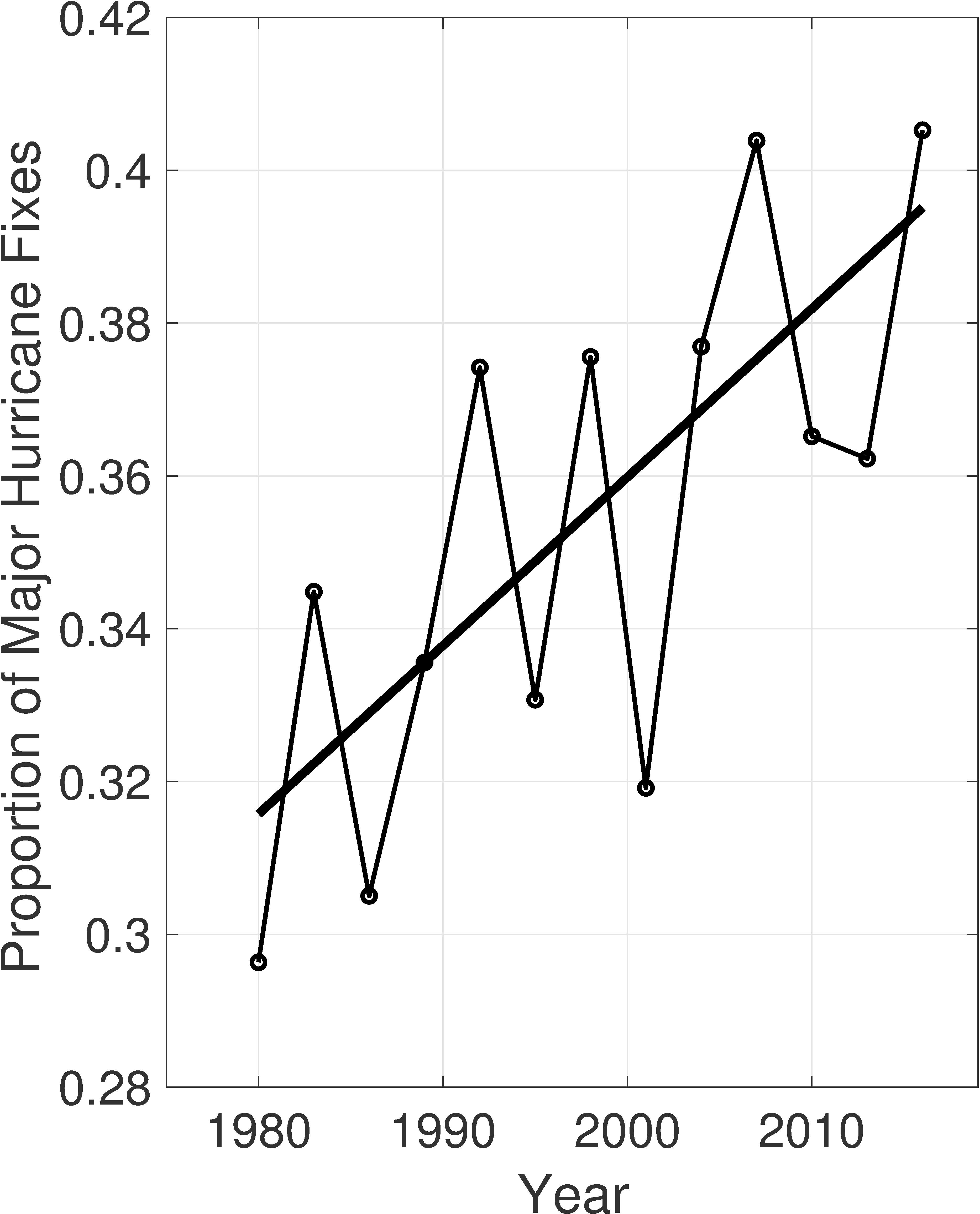
Manuscript Accepted in the Proceedings of the National Academy of Sciences: The manuscript "Global Increase in Major Tropical Cyclone Exceedance Probability Over the Past Four Decades" has been accepted in PNAS. The work is based on a collaboration between CIMSS scientists (Tim Olander and Chris Velden) and NOAA/NCEI scientists (Ken Knapp and Jim Kossin) under a NOAA CPO grant. Tropical cyclones (TCs), and particularly major TCs, pose substantial risk to many regions around the globe. Identifying changes in this risk and determining causal factors for the changes is a critical element for taking steps toward adaptation. Theory and numerical models consistently link increasing TC intensity to a warming world, but confidence in this link is compromised by difficulties in detecting significant intensity trends in observations. These difficulties are largely caused by known heterogeneities in the past instrumental records of TCs. In this work, a global geostationary satellite dataset is used to address and reduce these heterogeneities and significant global trends in TC intensity are identified over the past four decades. The results should serve to increase confidence in projections of increased TC intensity under continued warming. (J. Kossin, NOAA/NCEI, 608-265-5356)
 (Click image to enlarge)
Figure: Time series of fractional proportion of global major hurricane estimates to all hurricane estimates for the period 1979–2017. The linear Theil-Sen trend (black line) is significant at the 98% confidence level (Mann-Kendall P-value = 0.02). The proportion increases by 25% in the 39-year period (about 6% per decade).
WORKSHOPS, CONFERENCES, AND MEETINGS:
TRAINING AND EDUCATION:
VISIT Training on NUCAPS Soundings: Scott Lindstrom from the Cooperative Institute for Meteorological Satellite Studies (CIMSS) gave Virtual Institute for Satellite Integration Studies (VISIT) training on NOAA-Unique Combined Atmospheric Processing System (NUCAPS) profiles that are available in AWIPS at National Weather Service forecast offices. Forecasters from the Dodge City KS and Wichita KS forecast offices attended this live training event. (Scott Lindstrom, CIMSS, 608 263 4425)
Two VISIT Training modules updated: Scott Lindstrom from the Cooperative Institute for Meteorological Satellite Studies (CIMSS) updated two Virtual Institute for Satellite Integration Training (VISIT) modules this week. The training module on NOAA-Unique Combined Atmospheric Processing System (NUCAPS) profiles was updated with more examples of gridded NUCAPS data; The training module on NOAA/CIMSS ProbSevere was updated to include information on ProbSevere All Hazards (ProbWind, ProbHail, ProbTor). These training events are provided to National Weather Service forecasters and have become more popular during the current work-from-home environment. The training calendar can be viewed online at http://rammb.cira.colostate.edu/training/visit/calendar.asp. (S. Lindstrom, CIMSS, 608 263 4425)
MEDIA AND OUTREACH:
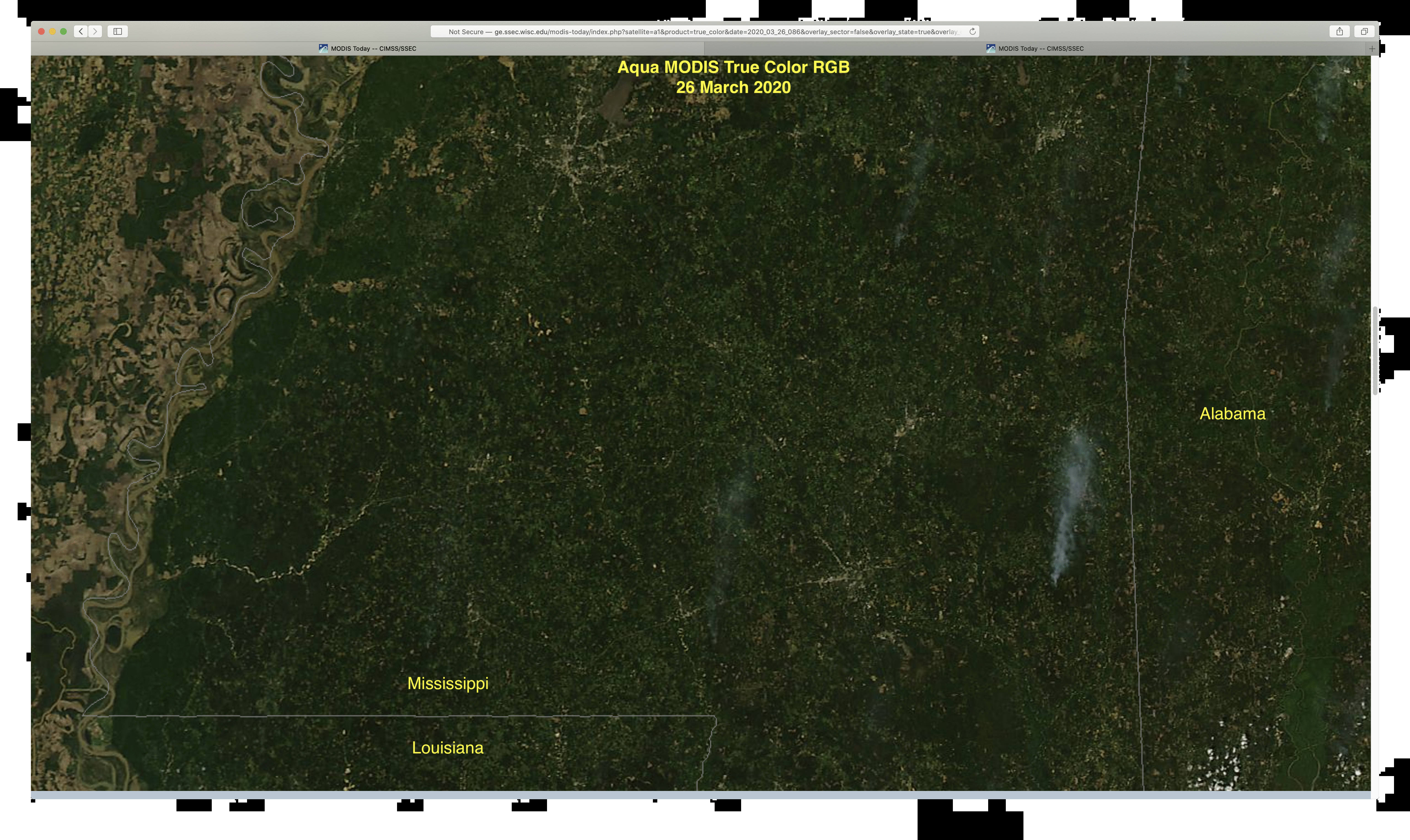
SSEC and CIMSS Scientists in the News: Scientists at the University of Wisconsin-Madison (UW) Space Science and Engineering Center (SSEC) and the Cooperative Institute for Meteorological Satellite Studies (CIMSS) provide expert commentary, interviews, and imagery to news media and participate in events to promote science. In the news this week: 1) SSEC Director Brad Pierce spoke with WISCTV in Madison, Wisconsin about NASA satellite measurements that indicate a reduction in nitrogen oxide resulting from 'shelter at home' policies during the coronavirus pandemic (https://go.wisc.edu/1p7aex). 2) CIMSS Satellite Blog contributors Scott Bachmeier and Scott Lindstrom published posts on "Outbreak of severe thunderstorms across the Deep South" (Apr. 12, 14) Read more at the CIMSS Satellite Blog (https://cimss.ssec.wisc.edu/satellite-blog/). (B. Pierce, SSEC, S. Bachmeier, CIMSS, J. Phillips, SSEC, 608-262-8164)
 (Click image to enlarge)
Figure: Aqua MODIS true color images show damage paths from tornadoes that struck Mississippi on Apr. 12, 2020. Also included are images from Mar. 26, 2020 for before and after comparisons. Credit: SSEC, MODIS Today.
Invited AGU Webinar Presentation: On Tuesday 14 April, Jim Kossin (NOAA/NCEI) gave an invited talk "Detecting Trends in Tropical Cyclones" as part of the AGU Atmospheric Sciences Webinar Series "From the Past Into the Future". The talk was part of an invitational session of the 2019 AGU Fall Meeting that turned out to be very popular and the room couldn't accommodate everyone who wanted to attend. All talks were consequently repeated and recorded during the Webinar series, which has spanned the past couple of months. As they become available, the recorded talks are placed on the AGU's YouTube page: https://www.youtube.com/user/AGUvideos/videos?view=0&sort=dd&flow=grid. (J. Kossin, NOAA/NCEI, 608-265-5356)
OTHER:
| Archived Weeklies Page | Submit a report item |