[ Archive ]
| CIMSS-NOAA Weekly Report [ Archive ] |
ASPB AND CIMSS WEEKLY HIGHLIGHTS FOR THE WEEK ENDING APRIL 24, 2020
PRODUCTS AND APPLICATIONS:
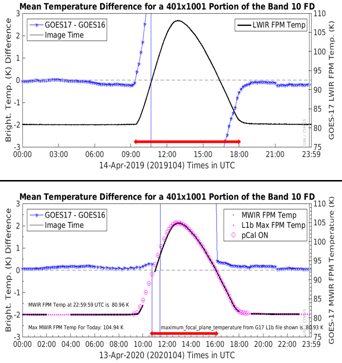
CIMSS GEO-GEO Monitoring Tool Upgrade: The web page created by Cooperative Institute for Meteorological Satellite Studies (CIMSS) researchers to help monitor Geostationary Operational Environmental Satellite (GOES)-17 Advanced Baseline Imager (ABI) data quality issues caused by the cooling system anomaly was upgraded recently. The page shows GOES-17 minus GOES-16 mean brightness temperature differences for a common scene and the upgrade included adding Focal Plane Module (FPM) temperatures obtained from the radiance data files and to add a circle marker to that time-series of FPM temperatures to indicate when GOES-17 has Predictive Calibration (pCal) turned on. This monitoring tool is used by CIMSS and ASPB researchers to detect issues with GOES-17 calibration and is currently being used to monitor the Mode 3 Cooling Timeline implementation that runs from April 9, 2020 to May 1, 2020 (http://cimss.ssec.wisc.edu/goes-r/abi-/16band_mainmenu.html). A preliminary PowerPoint report was presented to the GOES-R Calibration Working Group (CWG), including representatives from the Office of Satellite and Products Operations (OSPO) on April 22. (M. Gunshor, CIMSS, T. Schmit, E/RA2, 608-263-0291, tim.j.schmit@noaa.gov)
 (Click image to enlarge)
Figure: GEO-GEO difference plots showing GOES-17 minus GOES-16 mean brightness temperatures (blue asterisks) for an overlapping area at the Equator. Timeseries plots for day 104 in 2019 (top) vs 2020 (bottom) showing the hottest day of the April warming period (GOES-17 Focal Plane Module (FPM) temperatures are shown peaking near 13:00 UTC at over 107K in 2019 and just under 105K in 2020). This demonstrates both the recent changes made to the near-real-time generation of these plots (note magenta dots and circles in 2020 plot which are FPM temperature and Predictive Calibration indicator, respectively, taken from radiance file metadata) as well as the improvement to GOES-17 data quality due to the Mode 3 Cooling Timeline implementation (red lines near the x-axis showing the approximate time of data outage due to instrument warming were added for this comparison to show the improvement in 2020 since 2019 did not have the Cooling Timeline implemented).
AWARDS AND RECOGNITION:
PUBLICATIONS:
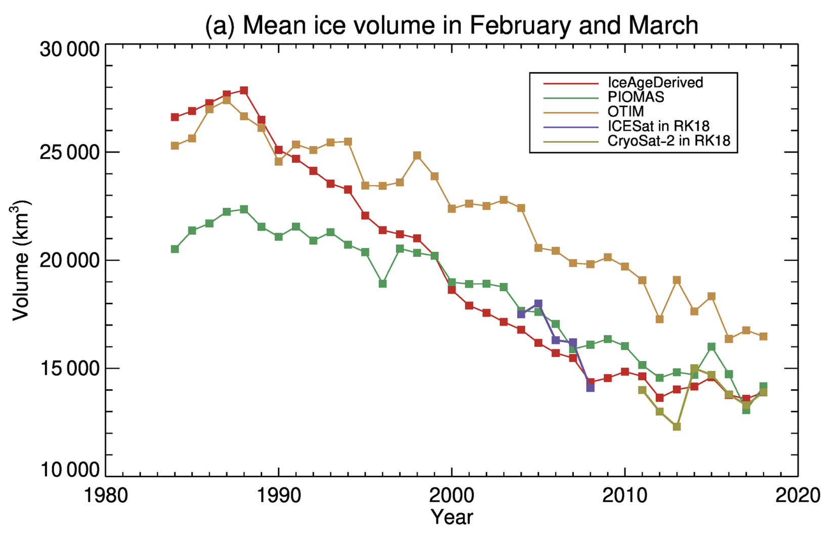
Paper published on a new multidecadal Arctic sea ice thickness and volume dataset: A paper titled "Multidecadal Arctic sea ice thickness and volume derived from ice age" has been published in the journal of The Cryosphere. This paper presents work to derive a new Arctic sea ice thickness and volume dataset from 1984 to 2018 based on the relationship of sea ice thickness and sea ice age. It is available at https://www.the-cryosphere.net/14/1325/2020/. The coauthors are Yinghui Liu (NOAA/NESDIS), Jeff Key (NOAA/NESDIS), Xuanji Wang (Cooperative Institute for Meteorological Satellite Studies), and Mark Tschudi (Colorado Center for Astrodynamics Research, University of Colorado Boulder). (Y. Liu, E/RA2, 608-890-1893, yinghui.liu@noaa.gov)
 (Click image to enlarge)
Figure: Mean Arctic ice volume in February and March over the period 1984 to 2018, derived from ice age, PIOMAS, OTIM, ICESat (2003–2007), and CryoSat2 (2011–2018) over the Arctic Ocean. From Liu et al. (2020).
WORKSHOPS, CONFERENCES, AND MEETINGS:
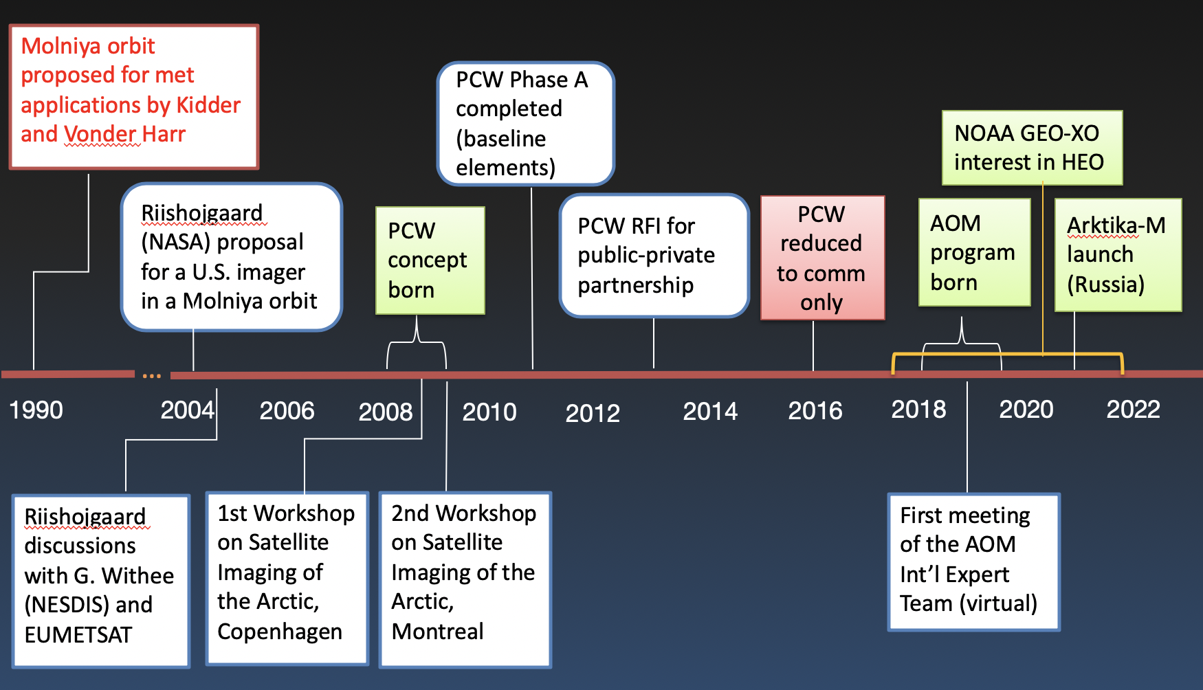
Presentation on a brief history of HEO mission plans: Jeff Key gave a presentation to the GEO-XO Working Group (XORWG) on April 21, 2020, titled, "A Brief Look at Recent Efforts to Improve Arctic Observing with Highly Elliptical Orbits". He described the timeline of international proposals and programs for putting an imager in a highly elliptical orbits (HEO) for meteorological applications (see figure), from a NASA proposal in 2004, the Canadian Polar Communication and Weather (PCW) mission around 2010, the current Canadian AIM-North/Arctic Observing Mission (AOM). NOAA's involvement in each program was highlighted. Russia's Arktika-M mission, planned for launch later this year, was also mentioned. (J. Key, E/RA2, 608-263-2605, jeff.key@noaa.gov)
 (Click image to enlarge)
Figure: Timeline of highly elliptical orbit (HEO) plans and programs for improving meteorological observations of the Arctic.
TRAINING AND EDUCATION:
VISIT Training on GOES-R IFR Probability fields: Scott Lindstrom from the Cooperative Institute for Meteorological Satellite Studies (CIMSS) gave Virtual Institute for Satellite Integration Studies (VISIT) training on GOES-R Instrument Flight Rule (IFR) Probability fields that are available in AWIPS at National Weather Service forecast offices via a Local Data Manager (LDM) feed from CIMSS to the National Weather Service. Forecasters from the Marquette, MI, and Medford, OR, forecast offices attended this live training event. (Scott Lindstrom, CIMSS, 608 263 4425)
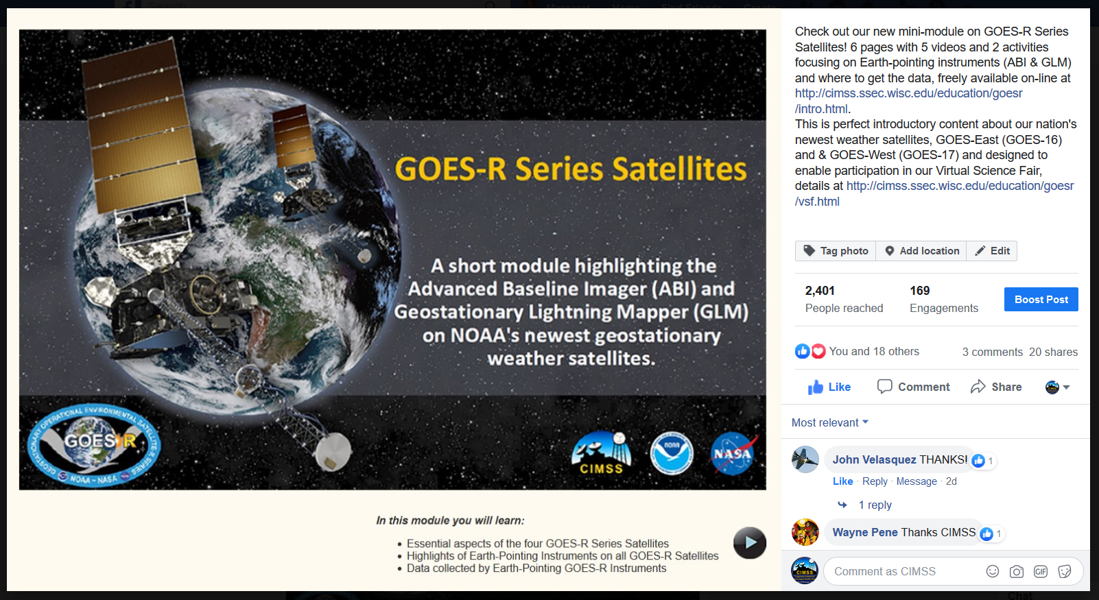
New mini-module on GOES-R Series Satellites: NOAA's Cooperative Institute for Meteorological Satellite Studies (CIMSS) recently released a new mini-module on GOES-R Series Satellites focusing on Earth-pointing instruments and where to get the data. The module consists of 6 pages with 5 videos and 2 activities, and is freely available on-line at http://cimss.ssec.wisc.edu/education/goesr/intro.html. When shared on social media two comments empathically exclaimed "THANKS" and "Thanks CIMSS". See the post at https://www.facebook.com/CIMSS.UW.Madison/photos/a.381001827219/10158333526502220/?type=3&theater. (M. Mooney, CIMSS, margaret.mooney@ssec.wisc.edu)
 (Click image to enlarge)
MEDIA AND OUTREACH:
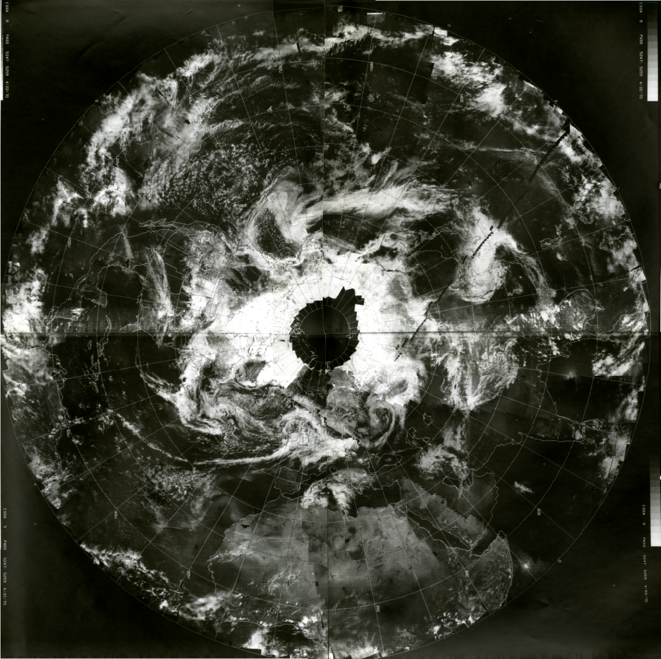
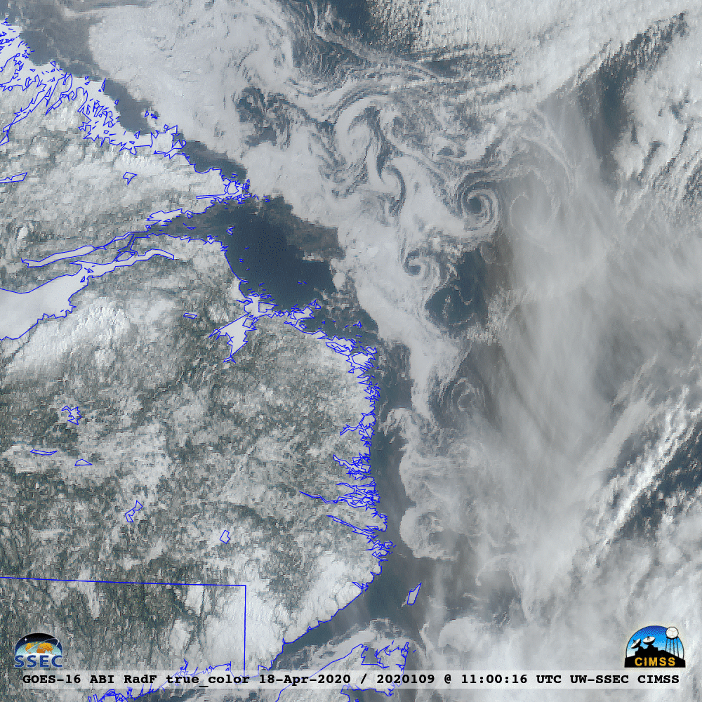
SSEC and CIMSS Scientists in the News: Scientists at the University of Wisconsin-Madison (UW) Space Science and Engineering Center (SSEC) and the Cooperative Institute for Meteorological Satellite Studies (CIMSS) provide expert commentary, interviews, and imagery to news media and participate in events to promote science. In the news this week: 1) SSEC News celebrated the 50th anniversary of Earth Day by sharing images of Earth from the SSEC data archives that date to the first Earth Day in 1970. (https://www.ssec.wisc.edu/news/articles/12750/) 2) CIMSS Satellite Blog contributors Scott Bachmeier and Scott Lindstrom published posts on "Severe weather in Oklahoma, Texas and Louisiana" (Apr. 22), "Gridded NUCAPS fields around nocturnal convection over the southern Plains" (Apr. 22), "Smoke from Asia over the North Pacific Ocean" (Apr. 21), "Another round of severe weather in the Deep South" (Apr. 19), "Ice in the Labrador Sea" (Apr. 18), and "Melting snow cover across the High Plains and Midwest" (Apr. 17). Read more at the CIMSS Satellite Blog (https://cimss.ssec.wisc.edu/satellite-blog/). (E. Verbeten, SSEC, S. Bachmeier, CIMSS, S. Lindstrom, CIMSS, J. Phillips, SSEC, 608-262-8164)
 (Click image to enlarge)
Figure: ESSA-9 image of Earth on the first Earth Day, Apr. 22, 1970. Credit: Schwerdtfeger Library, SSEC.
 (Click image to enlarge)
Figure: GOES-16 images revealed the complex motion of ice eddies in the Labrador Sea — off the coast of Labrador and Newfoundland, Canada — on Apr. 18, 2020. According to the Canadian Ice Service, this first-year ice was of below-normal concentration. Credit: SSEC, CIMSS, Geo2Grid.
OTHER:
| Archived Weeklies Page | Submit a report item |