[ Archive ]
| CIMSS-NOAA Weekly Report [ Archive ] |
ASPB AND CIMSS WEEKLY HIGHLIGHTS FOR THE WEEK ENDING MAY 15, 2020
PRODUCTS AND APPLICATIONS:
Flood Products in GEONETcast Americas: Flood product software, developed by George Mason University (GMU), are run routinely at the Cooperative Institute for Meteorological Satellite Studies (CIMSS). In response to user requests in South America, three products: hourly GOES-R series Advanced Baseline Imager (ABI) flood product composites, daily composites of Visible Infrared Imaging Radiometer Suite (VIIRS) flood product, and daily joint ABI/VIIRS composite flood product, are now being sent for distribution by NOAA's GEONETcast Americas. More information is available at https://geonetcast.wordpress.com/2020/05/14/noaa-leo-geo-flood-mapping-products-are-now-available-on-gnc-a-rebroadcast/ (GNC-A). (J. Hoffman, CIMSS, 608-780-1690, L. Gumley, SSEC, W. Straka III, CIMSS)
AWARDS AND RECOGNITION:
PUBLICATIONS:
WORKSHOPS, CONFERENCES, AND MEETINGS:
Global Cryosphere Watch Steering Group Meeting: The World Meteorological Organization (WMO) Global Cryosphere Watch (GCW) Steering Group held its seventh meeting, virtually, 11-13 May 2020. The main agenda topics were GCW's place in the new, major reorganization of WMO, the GCW pre-operational plan, approval of new GCW surface stations, the status of guides for "best practices", and a memorandum of agreement on the Third Pole Environment. There were participants from a number of European countries, Russia, North America, Australia, and China. Jeff Key is a member of the Steering Group. He provided guidance on the GCW Sea Ice Thickness Intercomparison Project (which he initiated two years ago). (J. Key, E/RA2, 608-263-2605, jkey@ssec.wisc.edu)
![]() (Click image to enlarge)
(Click image to enlarge)
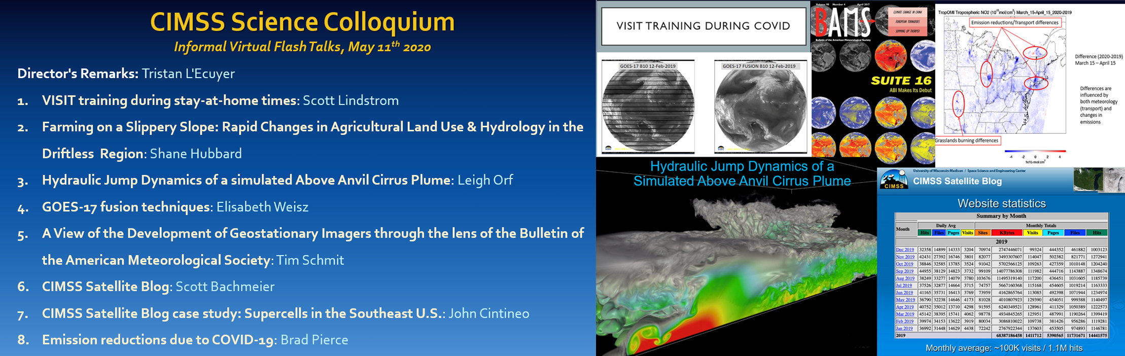
CIMSS Informal Science Colloquium: The Cooperative Institute for Meteorological Satellite Studies (CIMSS) held an informal "flash-talk" Science Colloquium on Monday May 11th featuring short virtual presentations by eight colleagues sharing details on projects they’re pursuing while working remotely. The event doubled as a social gathering to offset workplace isolation imposed by Covid-19 and the comradery was palpable. CIMSS plans to conduct monthly “flash talk socials” moving forward. (Tristan L'Ecuyer, CIMSS, M. Mooney, CIMSS, margaret.mooney@ssec.wisc.edu)
 (Click image to enlarge)
TRAINING AND EDUCATION:
VISIT Training on NUCAPS Profiles: Scott Lindstrom from the Cooperative Institute for Meteorological Satellite Studies (CIMSS) gave Virtual Institute for Satellite Integration Studies (VISIT) training on NUCAPS (NOAA-Unique Combined Atmospheric Processing System) Profiles that are available in AWIPS at National Weather Service forecast offices. The training includes information on individual profiles, how they can be modified in AWIPS, and on gridded thermodynamic fields that are derived from the NUCAPS profiles. This live training was given to the Warning Coordination Meteorologist (WCM) at the Boston Massachusetts forecast office. (Scott Lindstrom, CIMSS, 608 263 4425)
VISIT Training on NOAA/CIMSS ProbSevere: Scott Lindstrom from the Cooperative Institute for Meteorological Satellite Studies (CIMSS) gave Virtual Institute for Satellite Integration Studies (VISIT) training on the NOAA/CIMSS ProbSevere products that are used by National Weather Service forecasters to bolster confidence in warning issuance. The product suite includes ProbWind, ProbHail and ProbTor. This live training was given to forecasters at the Las Vegas (Nevada) Forecast Office. (Scott Lindstrom, CIMSS, 608 263 4425)
MEDIA AND OUTREACH:
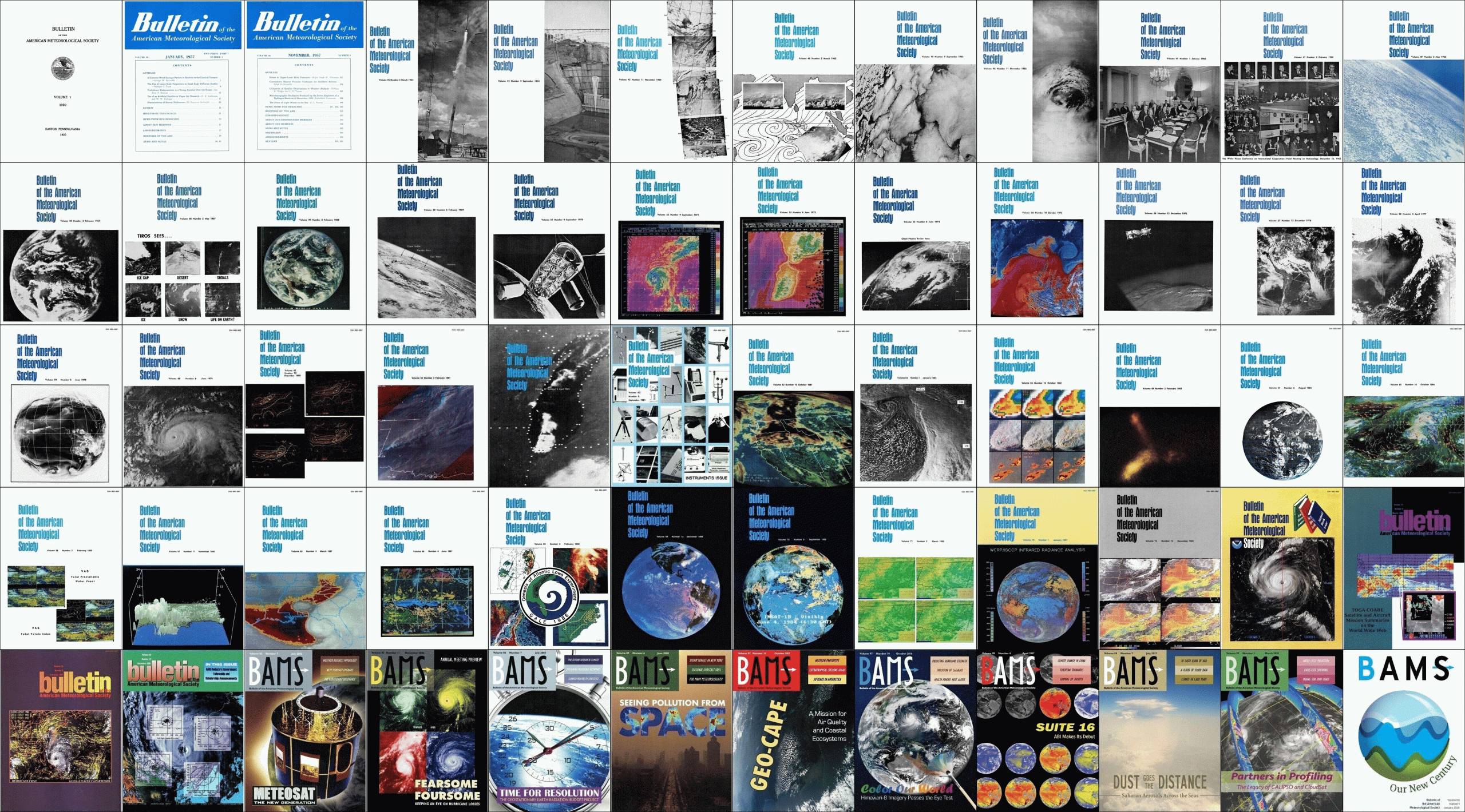
SSEC and CIMSS Scientists in the News: Scientists at the University of Wisconsin-Madison (UW) Space Science and Engineering Center (SSEC) and the Cooperative Institute for Meteorological Satellite Studies (CIMSS) provide expert commentary, interviews, and imagery to news media and participate in events to promote science. In the news this week: 1) CIMSS Satellite Blog contributors Tim Schmit and Scott Bachmeier published posts on "A View of the Development of Geostationary Imagers through the lens of BAMS" (May 14), "Typhoon Vongfong makes landfall in the Philippines" (May 14), "Blowing dust originating from the Gobi Desert in Mongolia" (May 12), "Mesoscale Convective Vortex in Texas" (May 12), "Midlatitude cyclone producing snow and high winds across the Upper Midwest" (May 9-10), and "Blowing dust off the coast of Australia" (May 8). Read more at the CIMSS Satellite Blog: https://cimss.ssec.wisc.edu/satellite-blog/. (T. Schmit, E/RA2, 608-263-0291, tim.j.schmit@noaa.gov, S. Bachmeier, CIMSS)
 (Click image to enlarge)
Figure: Selected covers from the Bulletin of the American Meteorological Society (AMS) showcasing the development of geostationary imagers, 1920-2020. Credit: AMS, NOAA, CIMSS.
 (Click image to enlarge)
Figure: JMA 2.5-minute rapid scan Himawari-8 “Clean” Infrared Window images showed Typhoon Vongfong during its rapid intensification to Category 3 intensity on May 13 and landfall on Samar Island in the Philippines as a Category 2 storm on May 14, 2020. Credit: CIMSS.
OTHER:
| Archived Weeklies Page | Submit a report item |