[ Archive ]
| CIMSS-NOAA Weekly Report [ Archive ] |
CIMSS AND ASPB WEEKLY HIGHLIGHTS FOR THE WEEK ENDING MAY 22, 2020
PRODUCTS AND APPLICATIONS:
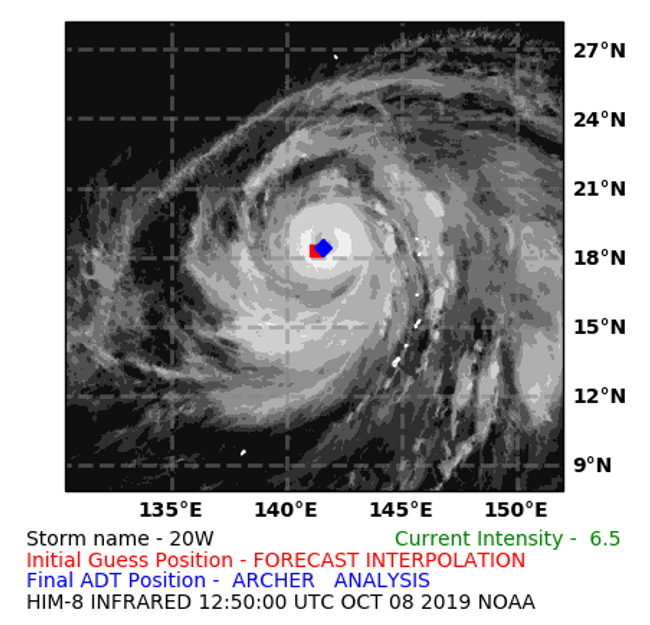
ADT completes Algorithm Readiness Review: The Cooperative Institute for Meteorological Satellite Studies (CIMSS) Advanced Dvorak Technique (ADT) Version 9.0 completed its Algorithm Readiness Review (ARR) on May 20, 2020. This review verifies that this latest version of the ADT, which estimates hurricane intensity from GOES IR imagery, is working within the STAR Development Environment and is ready to be delivered to NDE for operational implementation, currently scheduled for July/August of 2020. The ADT-V9.0 will replace the currently operational ADT-V8.2.1 running at OSPO. This algorithm update and migration is a Product System Development and Implementation (PSDI) effort in response to an approved Satellite Products and Services Review Board (SPSRB) request from the ADT user community. (T. Olander, CIMSS, 608-265-8005, C. Velden, CIMSS, 608-262-9168, J. Key, E/RA2, 608-263-2605, jeff.key@noaa.gov)
 (Click image to enlarge)
Figure: Sample graphical output file showing the initial “first-guess” position (forecast interpolation, in red) and final, objectively-determined storm center position (from ARCHER analysis, in blue) derived by the ADT algorithm.
AWARDS AND RECOGNITION:
PUBLICATIONS:
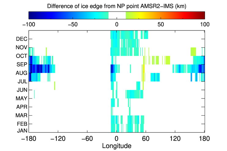
Paper published on AMSR2 sea ice extent and edge assessment using NOAA IMS: A paper titled, "Assessment of AMSR2 Ice Extent and Ice Edge in the Arctic Using IMS" has been published in the journal Remote Sensing. This study found good overall performance of Advanced Microwave Scanning Radiometer 2 (AMSR2) ice extent estimates, and Interactive Multisensor Snow and Ice Mapping System (IMS) ice edges extend further south compared to those from AMSR2. The paper is available at https://www.mdpi.com/2072-4292/12/10/1582. The coauthors are Yinghui Liu (NOAA/NESDIS), Sean Helfrich (NOAA/NESDIS), Walter Meier (National Snow and Ice Data Center), and Richard Dworak (Cooperative Institute for Meteorological Satellite Studies). (Y. Liu, E/RA2, 608-890-1893, yinghui.liu@noaa.gov)
 (Click image to enlarge)
Figure: Differences of monthly median ice edges from AMSR2 and IMS from 2015 to 2019 according to longitude. Absolute differences of less than 10 km are in white.
Using GEO water vapor measurements to evaluate several reanalysis: A paper has been published on the novel use of using homogenized geostationary water vapor measurements to evaluate a number of reanalysis. Specifically, the diurnal variation of upper tropospheric moisture information from international geostationary satellites was used to evaluate the diurnal variations from five modern reanalysis datasets. The full citation: Xue, Y.; Li, J.; Li, Z.; Gunshor, M.M.; Schmit, T.J. Evaluation of the Diurnal Variation of Upper Tropospheric Humidity in Reanalysis Using Homogenized Observed Radiances from International Geostationary Weather Satellites. Remote Sens. 2020, 12, 1628. The paper is available at https://www.mdpi.com/2072-4292/12/10/1628. (Jun Li, CIMSS, 608-262-3755, Jun.Li@ssec.wisc.edu; Tim Schmit, STAR, 608-263-0291, tim.j.schmit@noaa.gov)
WORKSHOPS, CONFERENCES, AND MEETINGS:
GSICS Executive Panel: A. Heidinger attended the Global Space-based Inter-calibration System (GSICS) Executive Panel Meeting which has hosted virtually by the European Organisation for the Exploitation of Meteorological Satellites (EUMETSAT). He gave an invited talk on the next generation of the International Satellite Cloud Climatology Project (ISCCP-NG) and its critical dependance on GSICS. ISCCP-NG is hoping to use all channels on the geo-ring of advanced imagers and is asking GSICS to extend their work to support them. ISCCP-NG also is asking GSICS to extend their InfraRed (IR) calibration correction to very cold temperatures to support cloud applications. A. Heidinger was assigned an action to host another meeting with the Visible and Near IR (VIS/NIR) and IR GSICS Working Groups to explore these issues further. (A. Heidinger, E/RA2, 608-263-6757, andrew.heidinger@noaa.gov)
TRAINING AND EDUCATION:
VISIT training on NOAA/CIMSS ProbSevere: Scott Lindstrom from the Cooperative Institute for Meteorological Satellite Studies (CIMSS) gave Virtual Institute for Satellite Integration Studies (VISIT) training on the NOAA/CIMSS ProbSevere products that are used by National Weather Service forecasters to bolster confidence in warning issuance. The product suite includes ProbWind, ProbHail and ProbTor. This live training was given to Science and Operations Officers (SOOs) from the Forecast Offices in Buffalo NY (BUF), Baltimore MD/Washington DC (LWX) and Pendleton OR (PDT). (Scott Lindstrom, CIMSS, 608 263 4425)
VISIT Training on Mesoscale Convective Vortices: Scott Lindstrom from the Cooperative Institute for Meteorological Satellite Studies (CIMSS) gave Virtual Institute for Satellite Integration Studies (VISIT) training on Mesoscale Convectively-Generated Vortices (MCVs) to forecasters at the Buffalo NY and Washington/Baltimore Forecast Offices. This remotely-given live training, originally created in 2004, was updated in 2019 by Scott Bachmeier, CIMSS and again in April 2020 by Scott Lindstrom. (Scott Lindstrom, CIMSS, 608 263 4425)
MEDIA AND OUTREACH:
SSEC and CIMSS Scientists in the News: Scientists at the University of Wisconsin-Madison (UW) Space Science and Engineering Center (SSEC) and the Cooperative Institute for Meteorological Satellite Studies (CIMSS) provide expert commentary, interviews, and imagery to news media and participate in events to promote science. In the news this week: 1) SSEC News published a story on the latest research by NOAA NCEI scientist James Kossin that identifies an increasing trend of hurricane intensification based on nearly 40 years of satellite imagery. CIMSS scientists Chris Velden and Tim Olander are co-authors on the study published in the Proceedings of the National Academy of Sciences. (https://www.ssec.wisc.edu/news/articles/12857/) . 2) CIMSS Satellite Blog contributors Scott Lindstrom and Scott Bachmeier published posts on "Severe thunderstorms in the High Plains (May 20), "Flooding along the Tittabawassee River in Michigan" (May 20), "Using Polar2Grid software to display historical MODIS data" (May 19), "Cyclone Amphan in the Bay of Bengal" (May 18), "40th anniversary of the Mount St. Helens eruption" (May 18), "Tropical Storm Arthur forms off the coast of Florida" (May 16), and "Back-building thunderstorms in Oklahoma" (May 15). Read more at the CIMSS Satellite Blog: https://cimss.ssec.wisc.edu/satellite-blog/. (J. Kossin, CIMSS, 608-265-5356, C. Velden, CIMSS, T. Olander, CIMSS, E. Verbeten, SSEC, S. Lindstrom, CIMSS, S. Bachmeier, CIMSS, J. Phillips, SSEC)
 (Click image to enlarge)
Figure: James Kossin, atmospheric research scientist with the NOAA National Centers for Environmental Information (NCEI) who is based at the University of Wisconsin-Madison. Credit: Bryce Richter, UW-Madison.
 (Click image to enlarge)
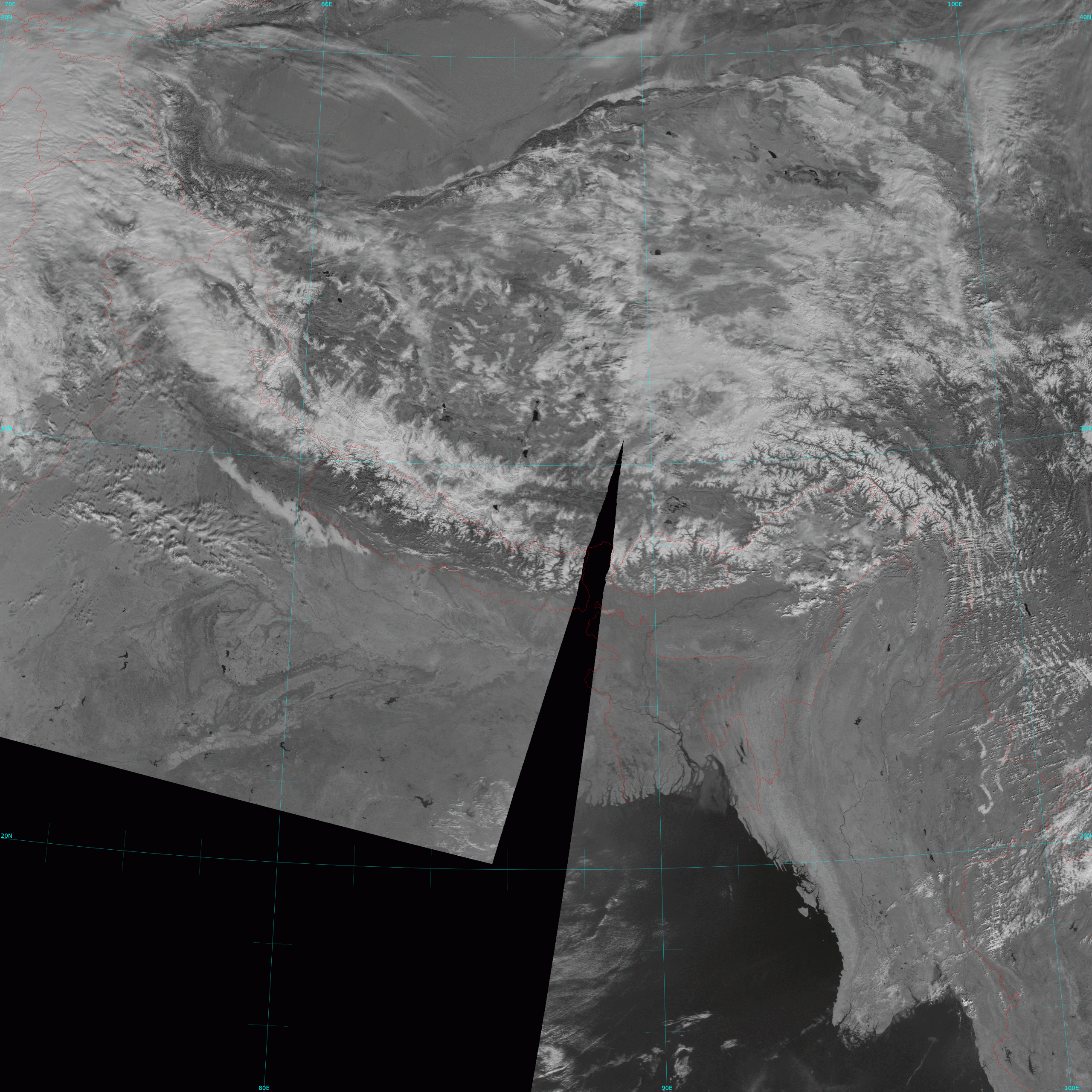
Figure: Archived MODIS data showing Mt. Everest on Jan. 28, 2004 displayed with CIMSS-developed Polar2Grid software. Credit: CIMSS, CSPP.
OTHER:
| Archived Weeklies Page | Submit a report item |