[ Archive ]
| CIMSS-NOAA Weekly Report [ Archive ] |
CIMSS AND ASPB WEEKLY HIGHLIGHTS FOR THE WEEK ENDING JUNE 19, 2020
PRODUCTS AND APPLICATIONS:
GOES-16 Fog/Low Stratus Products Declared Operational: On June 17, 2020, the NESDIS Satellite Products and Services Review Board (SPSRB) declared that the GOES-16 Advanced Baseline Imager (ABI) Fog/Low Stratus (FLS) products are ready for operational activation. The GOES-16 FLS algorithm utilizes machine learning and data fusion to determine the probability of critical aviation flight rule conditions. The FLS products were developed by the STAR Aviation Team at the Cooperative Institute for Meteorological Satellite Studies (CIMSS). The products will be made available to users through the NDE data distribution system after the next NDE update is installed, which is likely to occur in July 2020. The primary user of the products is the National Weather Service (NWS). The NWS will continue to rely on the experimental CIMSS data feed until the NDE data distribution has been activated and the Satellite Broadcast Network (SBN) is ready to distribute the products within the NWS. (M. Pavolonis, E/RA2, 608-263-9597, Mike.Pavolonis@noaa.gov; C. Calvert, CIMSS; S. Lindstrom, CIMSS)
AWARDS AND RECOGNITION:
PUBLICATIONS:
WORKSHOPS, CONFERENCES, AND MEETINGS:
TRAINING AND EDUCATION:
VISIT training on NOAA/CIMSS ProbSevere: Scott Lindstrom from the Cooperative Institute for Meteorological Satellite Studies (CIMSS) gave Virtual Institute for Satellite Integration Studies (VISIT) training on the NOAA/CIMSS ProbSevere products that are used by National Weather Service forecasters to bolster confidence in warning issuance. The product suite includes ProbWind, ProbHail and ProbTor. This live training was given to forecasters at the Duluth (MN, WFO DLH) Forecast Office. (Scott Lindstrom, CIMSS, 608 263 4425)
MEDIA AND OUTREACH:
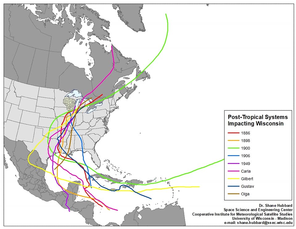
SSEC and CIMSS Scientists in the News: Scientists at the University of Wisconsin-Madison (UW) Space Science and Engineering Center (SSEC) and the Cooperative Institute for Meteorological Satellite Studies (CIMSS) provide expert commentary, interviews, and imagery to news media and participate in events to promote science. In the news this week: 1) CIMSS scientist Shane Hubbard's Facebook post, picked up by Marshall Shepherd for Forbes, provided historical context for a tropical depression in Wisconsin. (https://go.wisc.edu/asg5ju) 2) CIMSS Satellite Blog contributors Scott Bachmeier and Scott Lindstrom published posts on "ATMS imagery available via LDM from CIMSS" (June 18), "Saharan Air Layer dust continues to stream over the Atlantic Ocean" (June 17), "Inferring wind speed from ACSPO SSTs" (June 17), "Detection of Saharan Air Layer in the eastern Atlantic" (June 15), "Magnum Fire in northern Arizona" (June 13), "Cutoff low over northern Alaska" (June 12), "Shower initiation over Wisconsin" (June 12), and "Pyrocumulonimbus cloud spawned by the Bringham Fire in Arizona" (June 11). Read more at the CIMSS Satellite Blog: https://cimss.ssec.wisc.edu/satellite-blog/. (J. Phillips, SSEC, 608-262-8164, S. Hubbard, CIMSS, S. Bachmeier, CIMSS, S. Lindstrom, CIMSS)
 (Click image to enlarge)
Figure: Historical context for post-tropical storms impacting Wisconsin. Credit: S. Hubbard, CIMSS.
 (Click image to enlarge)
Figure: GOES-16 animation showing a dense plume of Saharan Air Layer dust as it streamed westward from Africa to the Eastern Atlantic Ocean on June 17, 2020. Credit: Geo2Grid, CIMSS.
OTHER:
| Archived Weeklies Page | Submit a report item |