[ Archive ]
| CIMSS-NOAA Weekly Report [ Archive ] |
CIMSS AND ASPB WEEKLY HIGHLIGHTS FOR THE WEEK ENDING JUNE 26, 2020
PRODUCTS AND APPLICATIONS:
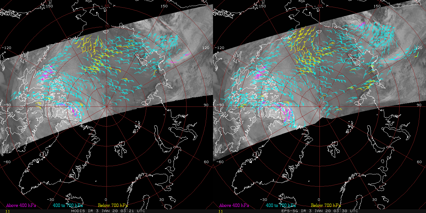
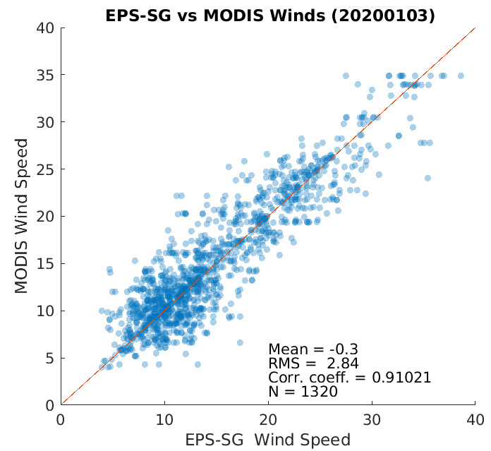
Initial Evaluation of Polar Winds from EPS-SG Simulated Data: The follow-on to the current Metop satellite series is the EUMETSAT Polar System-Second Generation (EPS-SG), with the first launch expected in 2023. In preparation for EPS-SG, a proxy dataset for the METimage sensor was produced and made available by the STAR calibration team. This dataset is composed of several orbits and was used by the Cooperative Institute for Meteorological Satellite Studies (CIMSS) polar winds team for an initial evaluation, using the heritage winds algorithm. The first figure shows a side-by-side visual comparison of the Terra Moderate Resolution Imaging Spectroradiometer (MODIS) infrared winds (left) and the EPS-SG METimage winds from simulated data (right) over the Arctic region, on 3 January 2020 at 0330 UTC. The spatial coverage and vertical distribution (color-coded) are very similar between the two, with an increased extent of winds due to a wider swath of the METimage sensor as compared to MODIS. The second figure is a scatterplot of the MODIS vs. METimage wind speed. The figure and statistics show very good agreement: The mean difference (METimage – MODIS wind speed) is -0.3 m/s; the RMS difference is 2.8 m/s; correlation coefficient is 0.9. (D. Santek, CIMSS, 608-263-7410, J. Key, E/RA2, 608-263-2605, jeff.key@noaa.gov, H. Zhang, CIMSS/SSEC)
 (Click image to enlarge)
Figure: MODIS (left) and METimage (right) polar winds from the infrared channel over the Arctic on 3 January 2020 at 0330UTC, color coded by height.
 (Click image to enlarge)
Figure: MODIS vs. METimage wind speed on 3 January 2020 at 0330UTC. The bias and RMS difference based on (METimage - MODIS) wind speed.
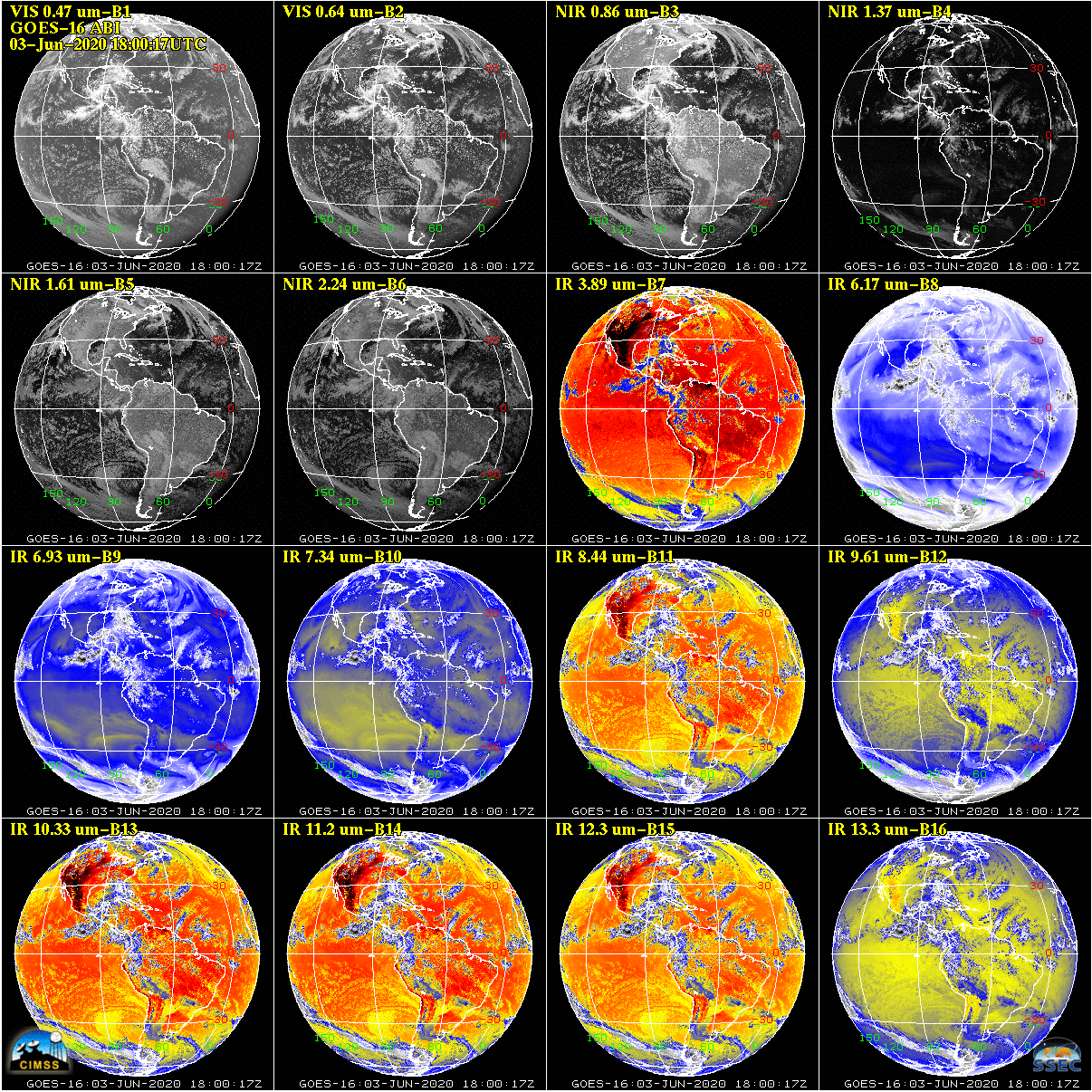
GOES-16 and -17 Level-1b Data Provided to NESDIS: On 03 June 2020, a data outage on the PDA (Product Distribution and Access) system prevented NESDIS operations from receiving GOES-16 and -17 Level-1b data needed for the production of various GOES products, including Atmospheric Motion Vectors (AMVs). Subsequent to this product outage it was observed that numerical model forecasts from the 00Z 04 June 2020 model run were degraded. NCEP (National Centers for Environmental Prediction) is currently investigating the effects of the product outages on this model run, and NESDIS is contributing to that study by reprocessing the missing AMVs. To that end, NESDIS contacted Tim Schmit (NOAA) at the University of Wisconsin-Madison, who worked with the Space Science and Engineering Center (SSEC) Data Center to provide NESDIS with the necessary Level-1b data. (T. Schmit, E/RA2, 608-263-0291, J. Nelson, CIMSS, 608-263-6013, J. Robaidek, SSEC, 608-262-6025)
 (Click image to enlarge)
Figure: All 16 bands of the GOES-16 ABI instrument, from 18:00:17UTC 03Jun2020.
AWARDS AND RECOGNITION:
PUBLICATIONS:
Two Research Papers Published: Two manuscripts were accepted for publication this week that deal with the sensitivity and assimilation of satellite data in numerical weather prediction. The two papers are: 1) Lewis, W., C. Velden and D. Stettner, 2020: Strategies for Assimilating High-Density Atmospheric Motion Vectors into a Regional Tropical Cyclone Forecast Model (HWRF), accepted in MDPI-Atmosphere. 2) Hoover, B., and C. Velden, 2020: Adjoint-Derived Impact of Assimilated Observations on Tropical Cyclone Intensity Forecasts of Hurricane Joaquin (2015) and Hurricane Matthew (2016), accepted in the Journal of Atmospheric and Oceanic Technology. (C. Velden, CIMSS, 608-262-9168)
WORKSHOPS, CONFERENCES, AND MEETINGS:
TRAINING AND EDUCATION:
VISIT training on NOAA/CIMSS ProbSevere: Scott Lindstrom from the Cooperative Institute for Meteorological Satellite Studies (CIMSS) gave Virtual Institute for Satellite Integration Studies (VISIT) training on the NOAA/CIMSS ProbSevere products that are used by National Weather Service forecasters to bolster confidence in warning issuance. The product suite includes ProbWind, ProbHail and ProbTor. This live training was given to forecasters at the Sioux Falls (SD, WFO FSD) Forecast Office. (Scott Lindstrom, CIMSS, 608 263 4425)
VISIT Training on Mesoscale Convective Vortices: Scott Lindstrom from the Cooperative Institute for Meteorological Satellite Studies (CIMSS) gave Virtual Institute for Satellite Integration Studies (VISIT) training on Mesoscale Convectively-Generated Vortices (MCVs) to forecasters at the Louisville, Kentucky Forecast Office. This remotely-given live training, originally created in 2004, was updated in 2019 by Scott Bachmeier, CIMSS. (Scott Lindstrom, CIMSS, 608 263 4425)
MEDIA AND OUTREACH:
SSEC and CIMSS Scientists in the News: Scientists at the University of Wisconsin-Madison (UW) Space Science and Engineering Center (SSEC) and the Cooperative Institute for Meteorological Satellite Studies (CIMSS) provide expert commentary, interviews, and imagery to news media and participate in events to promote science. In the news this week: 1) CIMSS Satellite Blog contributor Scott Bachmeier published posts on "Ice in Hudson Bay" (June 25), "Mesoscale Convective Vortex in Texas" (June 23), "Saharan Air Layer dust reaches the Lesser Antilles, Puerto Rico and the Gulf of Mexico" (June 21, 22, 24), "Solstice solar eclipse shadow moving across southern Asia" (June 21), and "Thunderstorms affecting American Samoa" (June 20). Read more at https://cimss.ssec.wisc.edu/satellite-blog/. (J. Phillips, SSEC, 608-262-8164, S. Bachmeier, CIMSS, 608-263-3958)
(Click image to enlarge)
Figure: A 17-day animation, June 8-24, 2020, of GOES-16 True Color RGB (daytime) and Dust RGB (nighttime) images showed a strong Saharan Air Layer dust plume reaching the Gulf of Mexico on June 24. A second dust plume developed off the northwest coast of Africa on June 22-23. Credit: Tim Schmit, ASPB, CIMSS.
 (Click image to enlarge)
Figure: Himawari-8 animation showing the shadow of a rare June Solstice solar eclipse moving across parts of Africa, the Arabian Peninsula and southern Asia on June 21, 2020. Credit: Geo2Grid, CIMSS.
OTHER:
| Archived Weeklies Page | Submit a report item |