[ Archive ]
| CIMSS-NOAA Weekly Report [ Archive ] |
CIMSS AND ASPB WEEKLY HIGHLIGHTS FOR THE WEEK ENDING JULY 3, 2020
PRODUCTS AND APPLICATIONS:
Comparison of 3D Winds Derived from Aeolus and Aqua AIRS Retrievals: As part of the NOAA Aeolus calibration/validation effort, a project at the Cooperative Institute for Meteorological Satellite Studies (CIMSS) is evaluating 3D winds from Aeolus as compared to those derived from hyperspectral IR sounders. Aeolus is the first mission to directly measure wind profiles throughout the troposphere and lower stratosphere using a Doppler Wind Lidar (DWL) instrument. This is a single horizontal line-of-sight (HLOS) instrument, which measures the component of the wind normal to the orbit path. An alternate method for deriving 3D winds has been the focus of NASA-sponsored research at the Space Science and Engineering Center (SSEC) using retrievals from the Atmospheric Infrared Sounder (AIRS) hyperspectral instrument on the Aqua satellite. 3D winds are derived by tracking moisture features (troposphere) and ozone gradients (stratosphere) from AIRS retrieved vertical profiles of temperature, humidity, and ozone in clear-sky and above-cloud. The Aeolus Rayleigh and AIRS wind products are similar in that they provide a 3D distribution of clear-sky winds in the stratosphere and troposphere. However, there are several inherent differences in the spatial coverage, temporal sampling, and the wind measurement itself from these two methods. Nevertheless, the initial comparisons are very good between co-located AIRS 3D winds and Aeolus winds (first figure). Moreover, the AIRS and Aeolus HLOS wind speeds compare favorably to HLOS-adjusted ERA5 reanalysis wind speeds (second figure). Because of the differences in the active vs. passive instruments and wind derivation methods, there is evidence these two sources of 3D winds may be complementary, with a similar measurement and quality of the resulting wind profiles. (D. Santek, CIMSS, 608-263-7410, B. Hoover, CIMSS/SSEC)
![]() (Click image to enlarge)
(Click image to enlarge)
Figure: Scatter plot of co-located high-quality AIRS HLOS-equivalent wind speed vs. Aeolus HLOS superob wind speed for August and September 2019
 (Click image to enlarge)
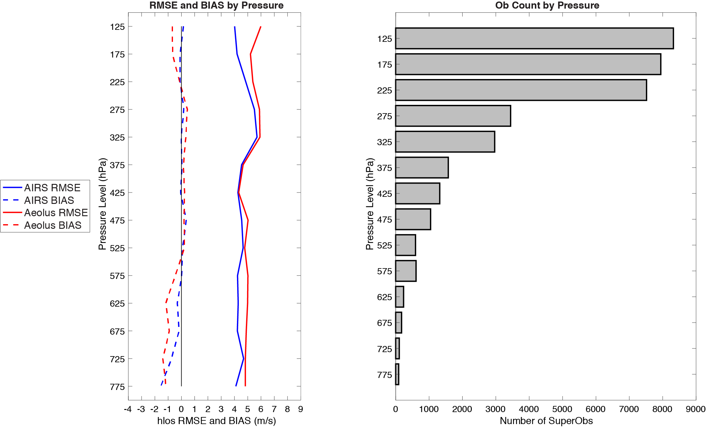
Figure: Vertical profile (left) of RMSE (solid) and bias (dashed) of AIRS (blue) and Aeolus (red) superob HLOS wind speed validating against ERA5 analysis, as a function of pressure level. In the right panel, the number of AIRS/Aeolus observations by pressure-bin. This is for ten days from August and September 2019.
AWARDS AND RECOGNITION:
PUBLICATIONS:
Paper on evapotranspiration published: A paper was published this month that investigates soil moisture-evapotranspiration coupling using the satellite-derived evapotranspiration stress index (ESI) and in-situ soil moisture and temperature observations. The paper is "Investigating the Relationship between the Evaporative Stress Index and Land Surface Conditions in the Contiguous United States" by Zhong, Y., J.A. Otkin, M.C. Anderson, and C. Hain, 2020, Journal of Hydrometeorology, 21, 1469-1486. (J. Otkin, CIMSS, 608-265-2476)
Paper on VIIRS-CrIS data fusion accepted for publication: A manuscript titled “Improvement in cloud retrievals from VIIRS through the use of infrared absorption channels constructed from VIIRS-CrIS data fusion” by Yue Li, Bryan A. Baum, Andrew K. Heidinger, W. Paul Menzel, and Elisabeth Weisz has been accepted by Atmospheric Measurement Techniques. This paper deals with the retrieval of semitransparent ice cloud properties from the Visible Infrared Imaging Radiometer Suite (VIIRS) satellite sensor on the Suomi-NPP and NOAA-20 platforms through fusion with the Crosstrack Infrared Sounder (CrIS). In comparison with the CALIPSO/CALIOP V4-20 cloud layer products and MODIS Collection 6.1 cloud top products, it is shown that the retrieved cloud top height for semitransparent ice clouds increases over non-polar regions and tends to be closer to the true CALIPSO/CALIOP cloud top height. Moreover, the uncertainty of cloud top height retrievals decreases globally for these clouds. This fusion approach overcomes one of the major deficiencies in the VIIRS cloud property determinations. (Yue Li, CIMSS, 608-890-4865)
WORKSHOPS, CONFERENCES, AND MEETINGS:
TRAINING AND EDUCATION:
VISIT Training on Above-Anvil Cirrus Plumes: Scott Lindstrom from the Cooperative Institute for Meteorological Satellite Studies (CIMSS) presented a Virtual Institute for Satellite Integration Training (VISIT) teletraining session on Above-Anvil Cirrus Plumes AACPs; these features of strong thunderstorms herald the appearance of very strong updrafts and are well-correlated with severe weather. This remote training was presented to forecasters at the Sterling, VA, forecast office (WFO LWX) (Scott Lindstrom, CIMSS, 608 263 4425)
MEDIA AND OUTREACH:
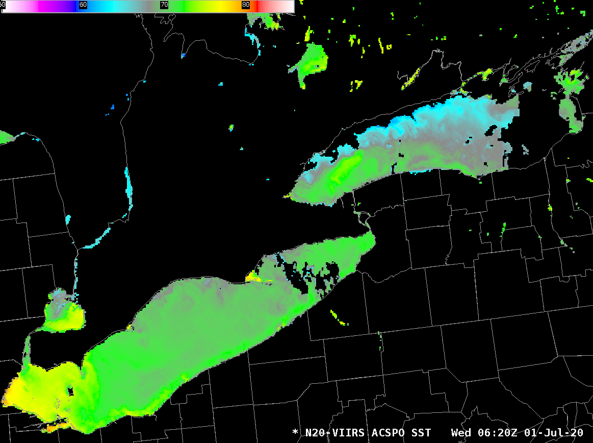
SSEC and CIMSS Scientists in the News: Scientists at the University of Wisconsin-Madison (UW) Space Science and Engineering Center (SSEC) and the Cooperative Institute for Meteorological Satellite Studies (CIMSS) provide expert commentary, interviews, and imagery to news media and participate in events to promote science. In the news this week: 1) SSEC scientist Shane Hubbard recently offered his expertise on disaster response during COVID-19 to SciLine, a service of the American Association for the Advancement of Science that helps connect journalists with scientific experts. Hubbard uses geospatial tools to model hazardous events like floods, tornadoes and hurricanes. He is a featured expert with UW News as well. Read more: https://www.sciline.org/covid-expert-quotes/disaster-response. 2) UW News featured SSEC scientist Scott Lindstrom as an expert available to talk with reporters about the Saharan Air Layer dust plume that developed over the Eastern Atlantic Ocean in June and moved westward. 3) CIMSS Satellite Blog contributors Scott Bachmeier and Scott Lindstrom published posts on "Fancy some time on the Lake? ACSPO SSTs show the warmest (and coolest) waters" (July 1), "Actinoform clouds near Hawai’i" (June30), "Severe thunderstorms over Wyoming and South Dakota" (June 28), and "Exploring the effects of GOES-17 parallax over Alaska" (June 27), Read more at the CIMSS Satellite Blog: https://cimss.ssec.wisc.edu/satellite-blog/. (J. Phillips, SSEC, 608-262-8164, S. Hubbard, CIMSS, 608-215-6059, S. Lindstrom, CIMSS, S. Bachmeier, CIMSS, 608-263-3958)
 (Click image to enlarge)
Figure: SSEC scientist Shane Hubbard offered his expertise on disaster response during COVID-19 to SciLine, a service of AAAS that helps connect journalists with scientific experts. Credit: S. Hubbard.
 (Click image to enlarge)
Figure: Early morning Lake Surface Temperatures (LST) over Lakes Erie and Ontario on July 1, 2020. LSTs are available via an LDM feed from CIMSS for insertion into AWIPS. Credit: CIMSS.
OTHER:
| Archived Weeklies Page | Submit a report item |