[ Archive ]
| CIMSS-NOAA Weekly Report [ Archive ] |
CIMSS AND ASPB WEEKLY HIGHLIGHTS FOR THE WEEK ENDING JULY 31, 2020
PRODUCTS AND APPLICATIONS:
AWARDS AND RECOGNITION:
PUBLICATIONS:
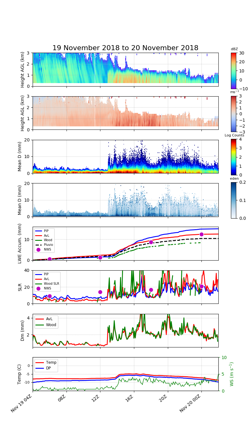
PIP Snow Paper Published in Atmosphere: A manuscript detailing the Precipitation Imaging Package (PIP) has been published in the journal Atmosphere this week. The lead author is Claire Pettersen (CIMSS/SSEC) and coauthors include Norm Wood (CIMSS/SSEC) and Mark Kulie (NOAA/NESDIS/STAR/ASPB), as well as others from NASA, Finnish Meteorological Institute, and University of Wisconsin - Madison. Dr. Pettersen is the instrument mentor and contact for the PIP. The PIP has been deployed at the long-term enhanced snow observation suite at the Marquette, Michigan NWS Office since 2014. This manuscript capitalizes on observations from the site and validates the automated PIP produced values of liquid equivalent snowfall rate and bulk snow density through comparisons to retrievals and coincident NWS observations. This work was supported by grants from NASA, NOAA, and the SSEC 2022 fund. This work will act as the main reference for the PIP snow products. The manuscript is available here: https://www.mdpi.com/2073-4433/11/8/785. (Attached figure illustrates a transition snowfall event - from high to low density.)
 (Click image to enlarge)
Figure: Example of a snow event that transitions from low to high snow to liquid ratio (SLR) snowfall from 19 to 20 November 2018. (a) Shown is data from the MRR reflectivity, (b) MRR Doppler velocity, (c) PIP-produced PSDs, (d) PIP-derived ρe distribution as a function of De, liquid water equivalent (LWE) accumulation for all three retrievals, (e) the Pluvio, and the NWS 6-hourly snow field, (f) calculated SLR from all three retrievals and the NWS 6-hourly snow field observations, (g) the mass-weighted diameter (Dm) from von Lerber and Wood, (h) and the surface meteorological conditions. All variables are presented as a function of time from 19 November at 0400 UTC to 20 November at 0200 UTC. The transition from low to high SLR occurs at approximately 1300 UTC.
WORKSHOPS, CONFERENCES, AND MEETINGS:
US CLIVAR Panel Presentation: Jason Otkin gave an invited presentation during the Summer Meeting of the U.S. CLIVAR Predictability, Predictions, and Applications Interface (PPAI) Panel. His presentation during the Drought Hazards session focused on discussing the characteristics and predictability of flash droughts. This topic has garnered increasing attention in the media and scientific community due to the occurrence of many high-impact flash drought events in the U.S. during the past decade. These climate events are characterized by a period of rapid drought intensification over sub-seasonal time scales that requires adjustments to existing drought monitoring and prediction methods. The presentation was given during their virtual meeting held on 20 July 2020. (J. Otkin, CIMSS, 608-265-2476)
TRAINING AND EDUCATION:
MEDIA AND OUTREACH:
CIMSS Satellite Blog Updates: The Cooperative Institute for Meteorological Satellite Studies (CIMSS) Satellite Blog (https://cimss.ssec.wisc.edu/satellite-blog/) was updated with the posts "Tropical Storm Gonzalo in the Atlantic" (July 24), "Hurricane Hanna makes landfall in Texas" (July 25), "Hurricane Douglas moves just north of Hawai’i" (July 26), "Vortices downwind of the Kuril Islands" (July 28), "Microwave Estimates of Total Precipitable Water" (July 28), "Potential Tropical Cyclone 9 intensifies to become Tropical Storm Isaias" (July 29), "Dry Air in the southwest Atlantic Ocean" (July 29) and "Satellite signatures of the Mars 2020 Perseverance Rover launch" (July 30). (S. Bachmeier, CIMSS, S. Lindstrom, CIMSS, 608.263.4425)
.png) (Click image to enlarge)
(Click image to enlarge)
Figure: NOAA-20 VIIRS I05 (11.45 µm) image of Tropical Storm Gonzalo, ca. 0400 UTC on July 24, 2020.
OTHER:
| Archived Weeklies Page | Submit a report item |