[ Archive ]
| CIMSS-NOAA Weekly Report [ Archive ] |
CIMSS AND ASPB WEEKLY HIGHLIGHTS FOR THE WEEK ENDING AUGUST 14, 2020
PRODUCTS AND APPLICATIONS:
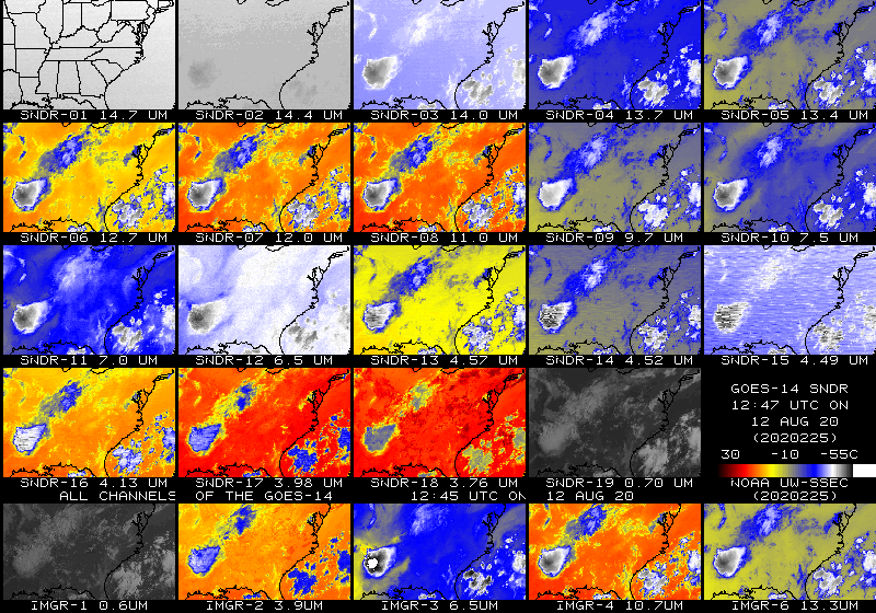
Experimental GOES-14 Imager and Sounder Data: Geostationary Operational Environmental Satellite (GOES)-14 recently came out of on-orbit storage for annual testing (https://www.ospo.noaa.gov/data/messages/2020/MSG195113402.html). In addition to performing several spacecraft maneuvers, test scans will also be performed. Near real-time Sounder imagery can be found under the GOES-14 "all bands" tab at http://cimss.ssec.wisc.edu/goes/rt/sounder-dpi.php. CIMSS and ASPB provided feedback regarding image quality. The Space Science and Engineering Center (SSEC) Data Services group was able to re-position a rooftop satellite dish and ingest the GOES-14 Imager and Sounder data in a timely manner. (T. Schmit, E/RA2, 608-263-0291, tim.j.schmit@noaa.gov; J. Robaidek, SSEC; J. Nelson, CIMSS; M. Gunshor, CIMSS)
 (Click image to enlarge)
Figure: 19 bands of the Geostationary Operational Environmental Satellite (GOES)-14 Sounder (top 4 rows) and 5 bands of the GOES-14 Imager (lower row) at approximately 13 UTC on 12 August 2020. All the bands have been remapped into the same projection. GOES-14 data are captured in real-time at the Space Science and Engineering Center (SSEC) Data Center in Madison, Wisconsin.
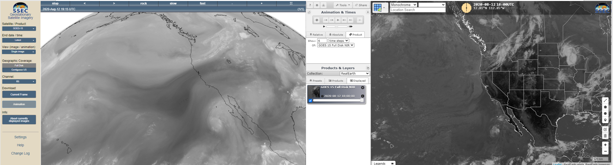
GOES-15 Imagery Posted: The University of Wisconsin-Madison Space Science and Engineering Center (SSEC) Data Services posted the GOES-15 imagery. This is from the supplemental operations of the GOES-15 Imager between August 9 and September 3, 2020. The imagery is posted for both the Full Disk and Pacific US sectors, both in the geo browser (https://www.ssec.wisc.edu/data/geo/#/animation?satellite=goes-15) and Real Earth (https://bit.ly/2Y0tpz2). (T. Schmit, E/RA2, 608-263-0291, tim.j.schmit@noaa.gov; M. Gunshor, CIMSS, 608-263-1146; J. Robaidek, SSEC Data Services)
 (Click image to enlarge)
Figure: Sample GOES-15 imagery from August 12, 2020, for the SSEC geo browser and Real Earth applications. The water vapor and shortwave window are shown, respectively.
AWARDS AND RECOGNITION:
PUBLICATIONS:
WORKSHOPS, CONFERENCES, AND MEETINGS:
Kickoff Meeting of New WMO Study Group on Cryosphere: As part of the major restructuring of the World Meteorological Organization (WMO), various Commissions, Standing Committees, Study Groups, and Expert Teams are being formed. The Study Group on Cryosphere (SG-Cryo) held its first meeting on 13 August 2020. While not a member of SG-Cryo, Jeff Key (NOAA) was asked to participate as a representative and member of the Infrastructure Commission's Standing Committee on Earth Observing Systems and Monitoring Networks (SC-ON). SG-Cryo will address the terms of reference for the Global Cryosphere Watch (GCW) and will advise on the fate of the WMO Polar Space Task Group (PSTG), for which Key has been Vice Chair, and the Executive Council Expert Panel on Polar and High Mountain Observations, Research, and Services (EC-PHORS), on which Key is a US representative. The group will also explore synergies with other international groups such as the World Climate Research Programme (WCRP), the Global Climate Observing System (GCOS), the Scientific Committee on Antarctic Research (SCAR), and others. Furthermore, SG-Cryo will seek an optimal integration of WMO activities relevant to the cryosphere within the new WMO governance structure. SG-Cryo has members from the US, Russia, Peru, Norway, France, Denmark, China, Canada, Austria, Australia, UK, Netherlands, and Iceland. (J. Key, E/RA2, 608-263-2605, jeff.key@noaa.gov)
TRAINING AND EDUCATION:
MEDIA AND OUTREACH:
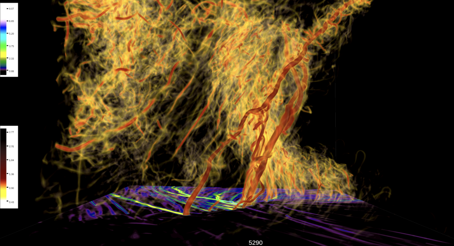
SSEC and CIMSS Scientists in the News: Scientists at the University of Wisconsin-Madison (UW) Space Science and Engineering Center (SSEC) and the Cooperative Institute for Meteorological Satellite Studies (CIMSS) provide expert commentary, interviews, and imagery to news media and participate in events to promote science. In the news this week. 1) CIMSS scientist Leigh Orf has been on the leading edge of efforts to create virtual tornadoes using powerful supercomputers. The Texas Advanced Computing Center featured his work in a story about supercell thunderstorms and how, and why, they can spawn tornadoes. (https://go.wisc.edu/pa21it) 2) CIMSS Satellite Blog contributors Scott Bachmeier and Scott Lindstrom published posts on "A view of California wildfire smoke from 4 GOES" (Aug. 13), "Midwest Derecho" (Aug. 10), "Mount Sinabung eruption in Indonesia" (Aug. 10), "Smoke across Brazil" (Aug. 9), "Severe thunderstorms in Minnesota" (Aug. 8), "Using CSPP QuickLooks and Direct Broadcast data to view gridded NUCAPS fields" (Aug. 7), and "Blowing dust off the coast of Namibia and South Africa" (Aug. 7). Read more: https://cimss.ssec.wisc.edu/satellite-blog/. (J. Phillips, SSEC, 608-262-8164, L. Orf, CIMSS, 608-890-1983, S. Bachmeier, CIMSS, 608-263-3958, S. Lindstrom, CIMSS)
 (Click image to enlarge)
Figure: The vorticity field of a multiple vortex EF5 tornado embedded within a supercell thunderstorm. The tornado vortex is the rightmost vertically erect vortex among several. A feature dubbed the Streamwise Vorticity Current (SVC) is evident as the diffuse yellow field that tilts from a horizontal orientation upwards behind and around the tornado. See: https://go.wisc.edu/pa21it. Credit: Leigh Orf, CIMSS.
 (Click image to enlarge)
Figure: 1-minute Mesoscale Domain Sector GOES-16 (GOES-East) imagery showing the eastward progression of a mesoscale convective system that produced a long swath of damaging winds, or derecho, from eastern Nebraska to Indiana on Aug. 10, 2020. See: https://cimss.ssec.wisc.edu/satellite-blog/archives/37938. Credit: CIMSS.
OTHER:
| Archived Weeklies Page | Submit a report item |