[ Archive ]
| CIMSS-NOAA Weekly Report [ Archive ] |
CIMSS AND ASPB WEEKLY HIGHLIGHTS FOR THE WEEK ENDING SEPTEMBER 18, 2020
PRODUCTS AND APPLICATIONS:
Teddy upgraded to Major Hurricane status based on CIMSS estimates: On September 17, 2020, the status of Hurricane Teddy was upgraded by the National Hurricane Center aided by objective intensity estimates from algorithms produced by the Cooperative Institute for Meteorological Satellite Studies (CIMSS). Here's the forecast discussion: "Hurricane Teddy Discussion Number 21, NWS National Hurricane Center Miami FL, 1100 AM AST Thu Sep 17 2020...Since the previous advisory, Teddy's satellite appearance has steadily improved. There is now a ragged warming eye surrounded by a ring of convection with cloud tops colder than -60 degrees C. Very recently the objective satellite intensity estimates from UW-CIMSS have been rapidly increasing. And although a blend of the 1130 and 1200 UTC Dvorak intensity estimates from SAB and TAFB, respectively, averaged out to an intensity of about 95 kt, the improved satellite presentation since that time suggests that the hurricane should have winds of at least 105 kt, which is the initial intensity for this advisory, which could even be a little conservative based on the latest UW-CIMSS ADT and SATCON values of 120 and 111 kt, respectively." The NOAA aircraft penetrating the hurricane shortly thereafter found 125 kt flight-level winds. (C. Velden, CIMSS, 608-262-9168; T. Olander, CIMSS; D. Herndon, CIMSS)
ABI Band Fact Sheets Now Available in French: Advanced Baseline Imager (ABI) band fact sheets are now available in French. Translation of the English versions was done by the Training and Career Development Division, Meteorological Service of Canada, Environment and Climate Change Canada (ECCC). The fact sheets have been posted at http://cimss.ssec.wisc.edu/goes/GOESR_QuickGuides_French.html. Thanks to J. Gerth, S. Lindstrom and many, many others for the original ABI band fact sheets. (T. Schmit, E/RA2, 608-263-0291, tim.j.schmit@noaa.gov; S. Lindstrom, CIMSS)
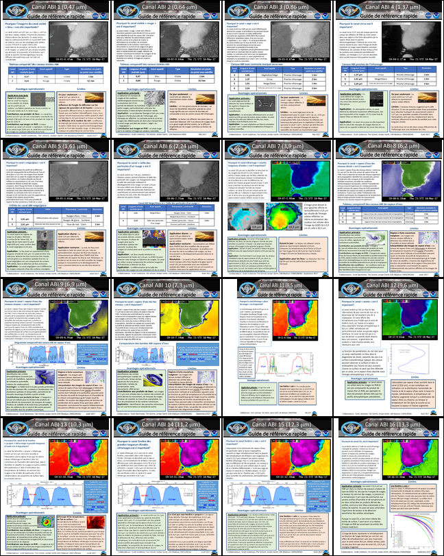 (Click image to enlarge)
Figure: Thumbnails of the front pages of the 16 ABI band French-language fact sheets that are now available.
AWARDS AND RECOGNITION:
PUBLICATIONS:
WORKSHOPS, CONFERENCES, AND MEETINGS:
Presentation at the National Weather Association Meeting from CIMSS: Scott Lindstrom from the Cooperative Institute for Meteorological Satellite Studies presented a poster at the 45th Annual Meeting of the National Weather Association, which was online this year. The topic was the Forecast Decision Training Division (FDTD) Satellite Applications Webinars (http://rammb.cira.colostate.edu/training/visit/satellite_chat/) that he coordinates with Dan Bikos from the Cooperatite Institute for Research in the Atmosphere (CIRA). These monthly events are peer-to-peer training events lead by National Weather Service forecasters. (S. Lindstrom, CIMSS, 608 263 4425)
TRAINING AND EDUCATION:
VISIT Training on IFR Probability fields: Scott Lindstrom from the Cooperative Institute for Meteorological Satellite Studies (CIMSS) gave Virtual Institute for Satellite Integration Training (VISIT) instruction on Instrument Flight Rule (IFR) Probability fields. These fields have recently begun flowing into National Weather Service Forecast Offices over the Satellite Broadcast Network (SBN). This live training event was to the Science and Operations Officer (SOO) and to a forecaster in the Grand Rapids MI (WFO GRR) forecast office. (Scott Lindstrom, CIMSS, 608 263 4425)
MEDIA AND OUTREACH:
New York Times Article on Hurricane Sally: Jim Kossin (NOAA/NCEI) gave a number of interviews (Reuters, Scientific American, Pix-11 TV in New York City, The New York Times) this week related to hurricanes and links to climate change, particularly on the slow movement of Hurricane Sally. The NYT article is at https://www.nytimes.com/2020/09/16/climate/hurricane-sally-climate-change.html. (Jim Kossin, NCEI, 608-265-5356)
CIMSS Flash Talk Social Event: NOAA’s Cooperative Institute for Meteorological Satellite Studies (CIMSS) held another in a series of informal on-line science talks on Monday September 14th featuring short virtual presentations on projects accomplished during work-from-home times. The monthly event doubles as a social gathering to connect with colleagues during a global pandemic. The line-up and a recording of the event is available at https://cimss.ssec.wisc.edu/education/flashtalks/. (M. Mooney, CIMSS, margaret.mooney@ssec.wisc.edu, Scott Lindstrom, CIMSS, scottl@ssec.wisc.edu)
SSEC and CIMSS Scientists in the News: Scientists at the University of Wisconsin-Madison (UW) Space Science and Engineering Center (SSEC) and the Cooperative Institute for Meteorological Satellite Studies (CIMSS) provide expert interviews, imagery and case studies to promote science. 1) SSEC Director Brad Pierce and UW Professor Ankur Desai spoke with WKOW27 about Western wildfires, their connection to climate change and whether the smoke from them will reduce air quality in the Midwest. More: https://go.wisc.edu/1v88m7. 2) CIMSS Satellite Blog contributors Scott Bachmeier and Scott Lindstrom published posts on "Hurricane Teddy rapidly intensifies to a Category 4 storm" (Sept. 17), "Medicane approaching Greece" (Sept. 17), "CMORPH estimates of hourly (and daily) rainfall with Sally" (Sept. 16), "Hurricane Sally makes landfall in Alabama" (Sept. 16", "Hurricane Sally" (Sept. 15), "Hurricane Sally in the northern Gulf of Mexico" (Sept. 14) and "Hurricane Gilbert: 1988 as seen by GOES-7" (Sept. 14). Read more: https://cimss.ssec.wisc.edu/satellite-blog/. (J. Phillips, SSEC, 608-262-8164, R.B. Pierce, SSEC, S. Bachmeier, CIMSS, S. Lindstrom, CIMSS, T. Schmit, E/RA2)
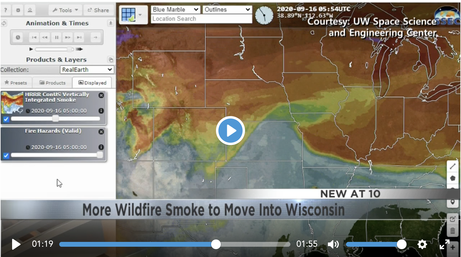 (Click image to enlarge)
Figure: Western wildfire smoke transport on Sept. 16, 2020 seen using NOAA's High Resolution Rapid Refresh (HRRR) Vertically Integrated Smoke forecast model along with NWS Fire Hazards products and displayed in SSEC's RealEarth. More at: https://go.wisc.edu/1v88m7.
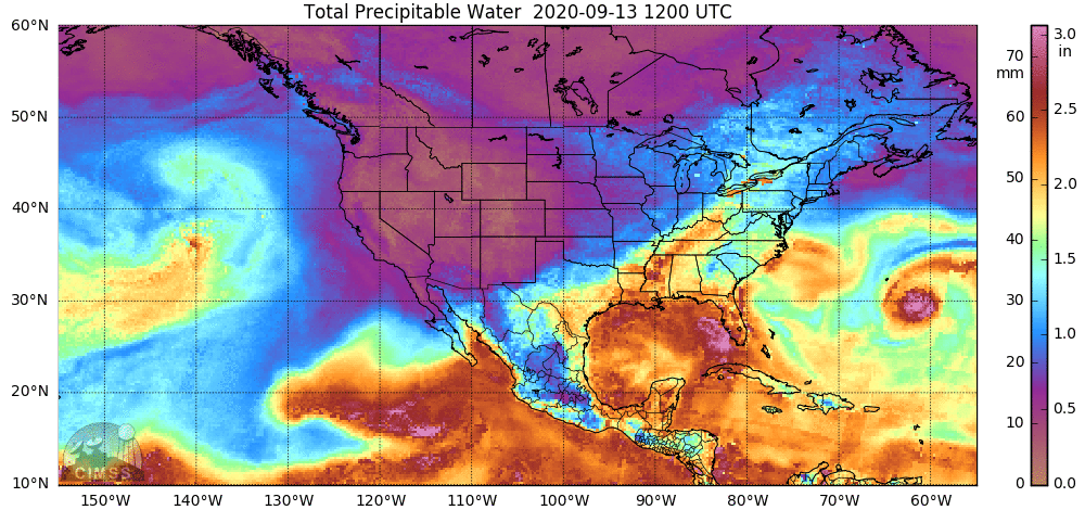 (Click image to enlarge)
Figure: Estimates of precipitable water for Hurricane Sally in the Gulf of Mexico for the 24 hours ending at 11 UTC on Sept. 14, 2020. Also seen are Hurricane Paulette moving over Bermuda and Pacific Tropical Storm Karina. Credit: CIMSS MIMIC-TPW, https://go.wisc.edu/575kq3.
 (Click image to enlarge)
Figure: Hurricane Gilbert, one of the most intense Atlantic hurricanes on record, as see from GOES-7 images, Sept. 10-17, 1988. The geostationary orbit offers synoptic as well as mesoscale views of the storm. Credit: CIMSS, NOAA, https://go.wisc.edu/1z7j4p.
OTHER:
| Archived Weeklies Page | Submit a report item |