[ Archive ]
| CIMSS-NOAA Weekly Report [ Archive ] |
CIMSS AND ASPB WEEKLY HIGHLIGHTS FOR THE WEEK ENDING SEPTEMBER 25, 2020
PRODUCTS AND APPLICATIONS:
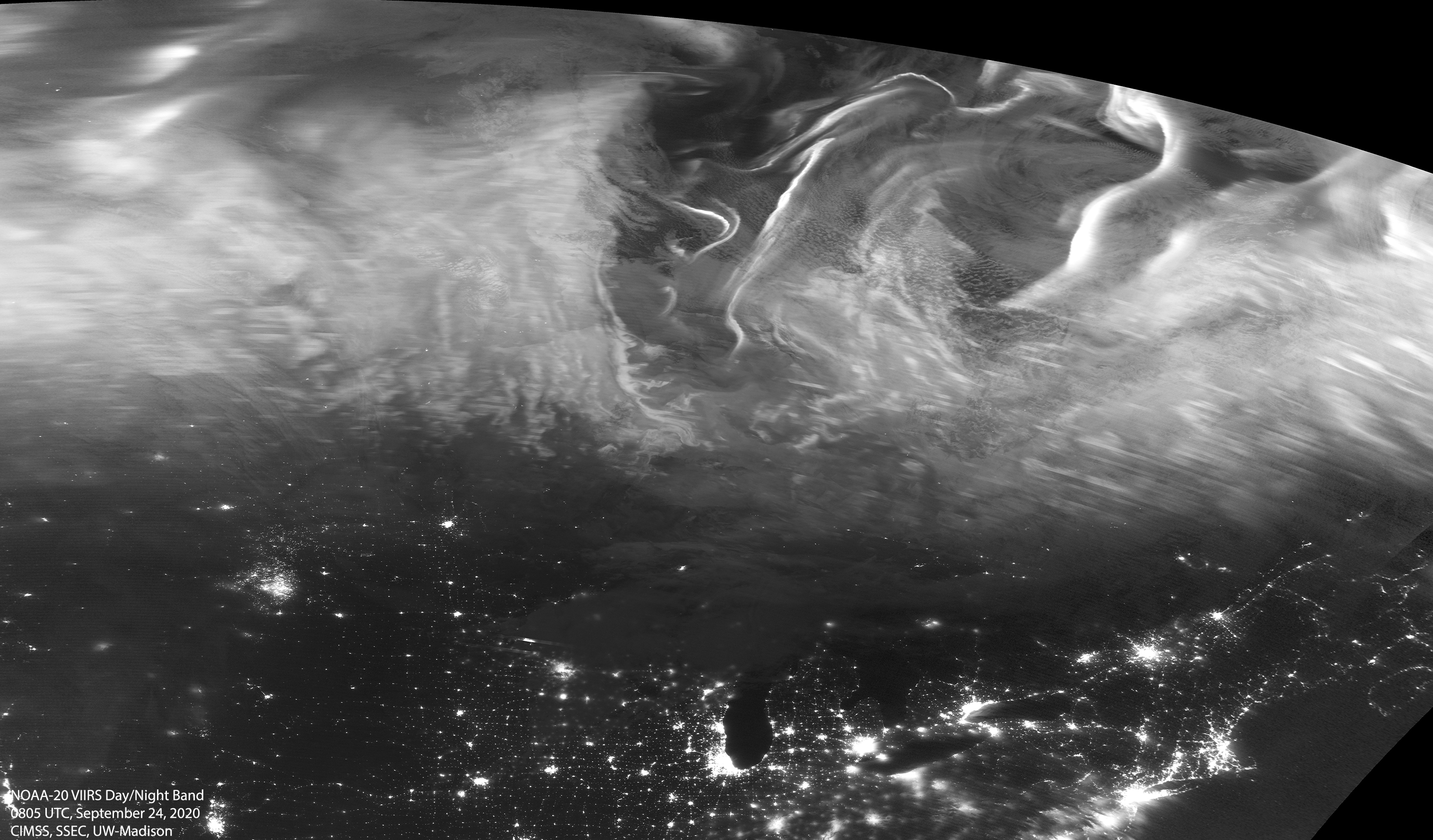
NOAA-20 View of the Aurora Borealis: The Space Science and Engineering Center, University of Wisconsin-Madison, acquired a spectacular image of the Aurora Borealis (Northern Lights) from the Visible Infrared Imaging Radiometer Suite (VIIRS) Day-Night Band (DNB) on the NOAA-20 satellite. The image was acquired at approximately 03:00 local time on 24 September 2020 and processed with the Community Satellite Processing Package (CSPP) at NOAA's Cooperative Institute for Meteorological Satellite Studies (CIMSS). Additional images are available on the CIMSS Facebook page at https://www.facebook.com/CIMSS.UW.Madison/posts/10158778354872220 with further discussion on the CIMSS Satellite Blog at https://cimss.ssec.wisc.edu/satellite-blog/archives/38464. (M. Mooney, CIMSS/SSEC, 608-265-2123, K. Strabala, CIMSS/SSEC)
 (Click image to enlarge)
AWARDS AND RECOGNITION:
PUBLICATIONS:
Paper published on the use of homogenized water vapor measurements: A paper has been published on the use of homogenized water vapor absorption radiance measurements from international geostationary satellites to evaluate several reanalysis, with a focus on the monthly variation of upper tropospheric water vapor (UTWV) over most of the globe. Studies show that the reanalyses capture the variation of UTWV well during the El Niño periods, but underestimate the UTWV gradient over tropical Pacific in the decay period, all reanalyses exhibit a dominant wet bias that is worth further research. The full citation: Xue, Y.; J. Li, Z. Li, R. Lu. M. Gunshor, S. Moeller, D. Di, and T. Schmit, 2020: Assessment of Upper Tropospheric Water Vapor Monthly Variation in Reanalyses with Near-Global Homogenized 6.5 µm Radiances from Geostationary Satellites, Journal of Geophysical Research: Atmospheres, http://dx.doi.org/10.1029/2020JD032695. (Jun Li, CIMSS; T. Schmit, E/RA2, 608-263-0291)
Book Chapter Published: Cooperative Institute for Meteorological Satellite Studies (CIMSS) Director Tristan L'Ecuyer is co-author of, "A Relational Vulnerability Analytic: Exploring Hybrid Methodologies for Human Dimensions of Climate Change Research in the Himalayas." It is a chapter in the 2020 book, "Himalayan Weather and Climate and their Impact on the Environment" published by Springer. Read more: https://link.springer.com/chapter/10.1007%2F978-3-030-29684-1_24. (T. L'Ecuyer, CIMSS)
WORKSHOPS, CONFERENCES, AND MEETINGS:
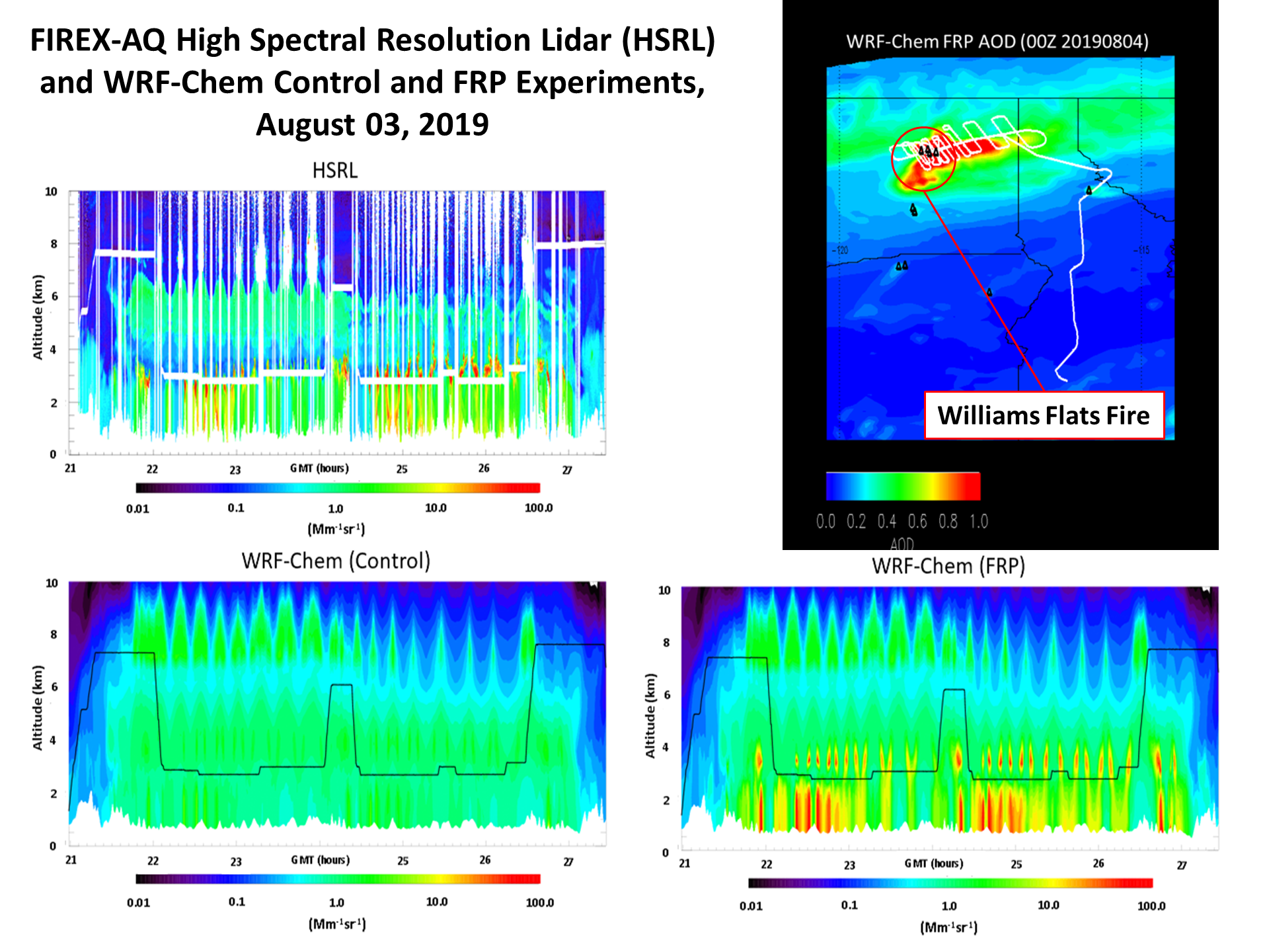
National Academy of Science Workshop on Wildland Fires: Brad Pierce participated as a wildfire forecasting panel member at the National Academy of Science “Wildland Fires: Towards Improved Understanding and Forecasting of Air Quality Impacts” workshop on September 23-25, 2020. The goal of the workshop was to bring together atmospheric chemistry and health research communities, managers, and decision makers to discuss knowledge and needs surrounding how wildfire effluent affects air quality and human health. He provided advice on current and future satellite observations of wildfires and associated air quality impacts and how these measurements are assimilated within regional and global air quality forecast models to improve predictions of wildfire pollution. Results from high resolution UW-Madison WRF-Chem retrospective wildfire forecasts conducted during the 2019 NASA/NOAA FIREX-AQ field campaign using GOES-16 Advance Baseline Imager (ABI) Fire Radiative Power (FRP) retrievals where highlighted. These experiments show significant improvements in predicted aerosol backscatter and injection heights when GOES-16 FRP is used for wildfire emissions and plume rise calculations compared to control experiments without GOES-16 FRP (R. B. Pierce, SSEC, 608-890-1892, rbpierce@wisc.edu, A. Kumar, SSEC, 608-263-4683, C. Schmidt, CIMSS, 608-262-7973)
 (Click image to enlarge)
Figure: Comparisons between WRF-Chem Control (lower left panel), WRF-Chem FRP (lower right panel) and High Spectral Resolution Lidar (HSRL, John Hair/NASA LaRC) aerosol backscatter measurements (upper left , Mm-1sr-1) during FIREX-AQ DC8 transects through the Williams Flats fire plume on August 3, 2019 (upper right panel) show significant improvement in predicted aerosol backscatter and injection heights when GOES-16 FRP retrievals are used for WRF-Chem emissions and plume injection heights. [Retrospective WRF-Chem experiments conducted by Aditya Kumar, SSEC]
TRAINING AND EDUCATION:
MEDIA AND OUTREACH:
Climate Central Hurricane Story: In collaboration with Jim Kossin (NOAA/NCEI), Climate Central posted a story on the results of a recent PNAS paper by NOAA and CIMSS authors, which found global increases in tropical cyclone intensity over the past four decades. The story appears at https://medialibrary.climatecentral.org/resources/2020-stronger-hurricanes. (J. Kossin, NOAA/NCEI, 608-265-5356)
SSEC and CIMSS Scientists in the News: Scientists at the University of Wisconsin-Madison (UW) Space Science and Engineering Center (SSEC) and the Cooperative Institute for Meteorological Satellite Studies (CIMSS) provide expert interviews, imagery and case studies to promote science. 1) Imagery from CIMSS Satellite Blog posts was picked up by the U.S. Naval Research Laboratory for a story on environmental effects of pyrocumulonimbus plumes and The Washington Post, for a story on the 2020 Atlantic hurricane season. Read more: https://go.wisc.edu/i7lx75, https://go.wisc.edu/f8xkqh. 2) CIMSS Satellite Blog contributors Scott Lindstrom and Scott Bachmeier published posts on "VIIRS views of the surface and atmosphere, late September 2020 version" (Sept. 24), "ACSPO Lake Surface Temperatures over the Great Lakes" (Sept. 23), "Hurricane Teddy and wildfire smoke" (Sept. 22), "Medicane Ionas after Greece" (Sept. 21), "VIIRS Day Night Band imagery of Beta off the coast of Texas" (Sept. 21", "Tropical Storm Beta in the Gulf of Mexico" (Sept. 20) and "Pyrocumulonimbus clouds produced by the Mullen Fire in Wyoming" (Sept. 19). Read more: https://cimss.ssec.wisc.edu/satellite-blog/. (J. Phillips, SSEC, S. Bachmeier, CIMSS, S. Lindstrom, CIMSS)
 (Click image to enlarge)
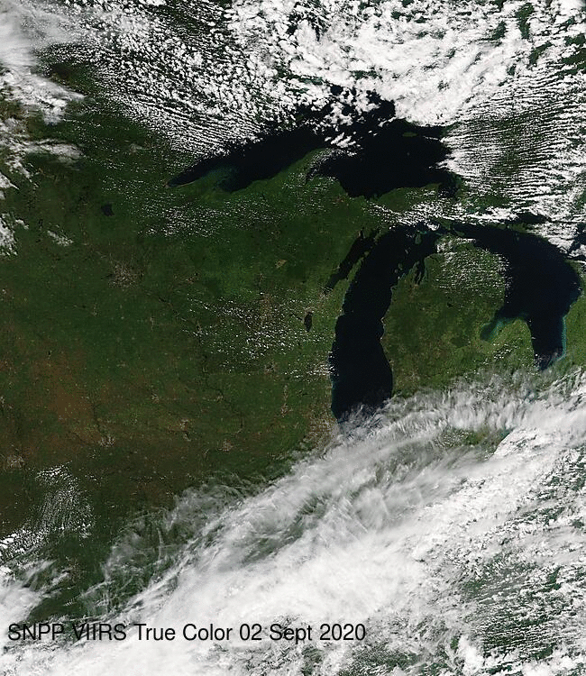
Figure: VIIRS true color imagery of the Upper Midwest on Sept. 2 and Sept. 20, 2020 provides a snapshot of the region's transition from summer to fall, showing trees changing from green to red/gold/brown. Credit: CIMSS, VIIRS Today.
 (Click image to enlarge)
Figure: CIMSS Satellite Blog analysis of GOES-16 images on Sept. 22 showed the large circulation of Hurricane Teddy drawing smoke, likely from western US wildfires, in a southerly direction from Canada and New England out over the Atlantic Ocean. Credit: CIMSS, Geo2Grid.
OTHER:
| Archived Weeklies Page | Submit a report item |