[ Archive ]
| CIMSS-NOAA Weekly Report [ Archive ] |
CIMSS AND ASPB WEEKLY HIGHLIGHTS FOR THE WEEK ENDING OCTOBER 9, 2020
PRODUCTS AND APPLICATIONS:
AMSR2 sea ice concentration scheduled for NCO operations: Operationalization of the NOAA AMSR-2 sea-ice concentration data stream in NCEP Central Operations (NCO) was completed in early October 2020. The product is generated by STAR's GCOM-W1 AMSR-2 Algorithm Software Processor (GAASP). This implementation continues the existing NESDIS/OSPO Product Distribution and Access (PDA) ingest and establishes delivery to the NCO operational data tank. Previously, the NCEP Environmental Modeling Center (EMC) was using the AMSR2 sea ice concentration data only for development and validation. This is a transition of the sea ice data from development to operations in the Real-Time Ocean Forecast System – Data Assimilating (RTOFS-DA). Establishing this and other operational satellite ocean observation data streams directly enables transitioning of RTOFS-DA and NOAA's West Coast Operational Forecast System (WCOFS) to operations in November 2020 and January 2021, respectively. RTOFS-DA is NWS's first global ocean model to implement NOAA data assimilation. WCOFS is the National Ocean Service's first operational data-assimilating model and forecast system. (J. Key, E/RA2, 608-263-2605, jeff.key@noaa.gov; E. Bayler, STAR)
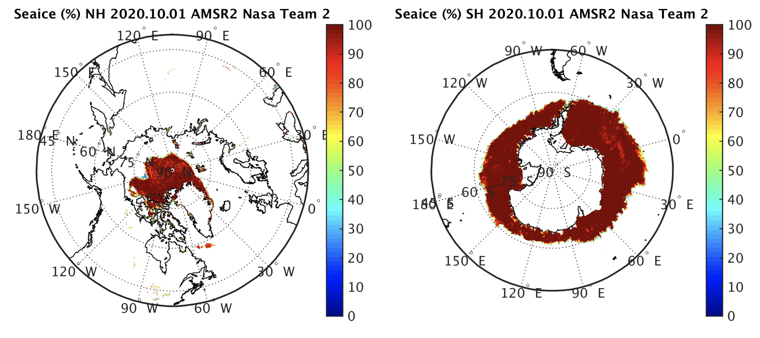 (Click image to enlarge)
Figure: AMSR2 sea ice concentration on 1 October 2020 for the Arctic (left) and Antarctic (right).
Hurricane Delta winds from GOES-16 Meso Scans: Experimental enhanced atmospheric motion vector (AMV) datasets are being produced in real time during Atlantic tropical cyclones by researchers at the Cooperative Institute for Meteorological Satellite Studies at the University of Wisconsin (UW-CIMSS). Very high spatiotemporal vortex-scale datasets at 15-minute intervals are being derived using GOES-16 multispectral images from the Meso sector scans targeting tropical systems. This week, the GOES-16 meso scans followed Hurricane Delta as it developed into a major hurricane ultimately making landfall in Louisiana. An example of the AMV datasets for a period of time during Delta's approach to the U.S. coast is shown in the accompanying animation. AMVs are produced using the GOES-R Algorithm Working Group (AWG) tracking software with processing strategies designed to optimize the use of the 1-min. meso scans and maximize the coverage density to capture hurricane-scale flow features. Additional AMVs (shown in magenta in the example animation) are derived from an experimental optical flow algorithm that augments the coverage over the very cold and coherent central dense overcast region of the storm. (C. Velden, CIMSS, 608-262-9168; D. Stettner, CIMSS, 608-262-8850; R. Rabin, NOAA/NSSL and CIMSS, 608-264-5325/405-366-0583; S. Wanzong, CIMSS, 608-263-1950; J. Daniels, STAR; W. Bresky, STAR)
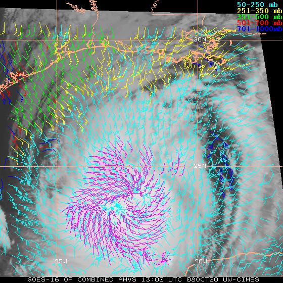 (Click image to enlarge)
Figure: Demonstrational animation of AMV datasets produced in real time at 15-minute intervals over a 10-hour period from GOES-16 meso scans during Hurricane Delta. The colors indicate the vector heights (hPa), and the magenta vectors are derived from an experimental optical flow method.
AWARDS AND RECOGNITION:
PUBLICATIONS:
WORKSHOPS, CONFERENCES, AND MEETINGS:
TRAINING AND EDUCATION:
Training for Myanmar Department of Meteorology and Hydrology: Scott Lindstrom, Cooperative Institute for Meteorological Satellite Studies (CIMSS), gave ten daily 3-hour remotely-presented training lectures during the weeks of 28 September – 2 October and 5 October – 9 October to about 30 members of the Myanmar Department of Hydrology and Meteorology. The topic was Synoptic and Dynamic Tropical and Extratropical Meteorology and was a follow-on to in-person training (cut short by COVID-19) in March 2020. This was training sponsored by the World Meteorological Organization (WMO), and funded through COMET. (Scott Lindstrom, CIMSS, 608 263 4425)
MEDIA AND OUTREACH:
SSEC and CIMSS Scientists in the News: Scientists at the University of Wisconsin-Madison (UW) Space Science and Engineering Center (SSEC) and the Cooperative Institute for Meteorological Satellite Studies (CIMSS) provide expert interviews, imagery and case studies to promote science. This week: 1) NOAA NCEI scientist Jim Kossin, interviewed by Associated Press and The New York Times, described aspects of climate change that are making storms like Hurricane Delta more destructive. Read more: https://go.wisc.edu/0i1ndw, https://go.wisc.edu/l15uxs. 2) CIMSS scientist William Straka III provided VIIRS images to NOAA and engineering.com for stories on the moon and Western US wildfires. Read more: https://go.wisc.edu/f54q1w, https://go.wisc.edu/15p6tq. 3) CIMSS Satellite Blog contributors Scott Lindstrom and Scott Bachmeier published case studies on "Typhoon Chanhom south of Japan" (Oct. 9), "Tropical Storm Delta becomes a Hurricane" (Oct. 6-7), and "Hurricane Marie in the East Pacific Ocean" (Oct. 2-3). Read more: https://cimss.ssec.wisc.edu/satellite-blog/archives/38484. (J. Phillips, SSEC, 608-262-8164, J. Kossin, NOAA NCEI/CIMSS, 608-265-5356, W. Straka III, CIMSS, S. Lindstrom, CIMSS, S. Bachmeier, CIMSS)
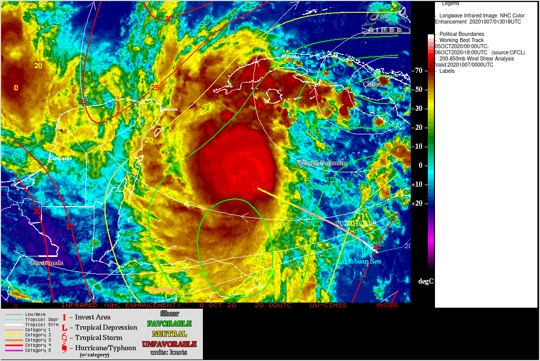 (Click image to enlarge)
Figure: GOES-16 Infrared Window (11.2 µm) imagery showed Hurricane Delta on Oct. 6-7, 2020 as it encountered low, deep-layer wind shear while moving over very warm ocean waters. Credit: CIMSS Tropical Cyclones and CIMSS Satellite Blog.
OTHER:
| Archived Weeklies Page | Submit a report item |