[ Archive ]
| CIMSS-NOAA Weekly Report [ Archive ] |
CIMSS AND ASPB WEEKLY HIGHLIGHTS FOR THE WEEK ENDING OCTOBER 16, 2020
PRODUCTS AND APPLICATIONS:
ProbSevere Promoted to Operations: The ProbSevere nowcasting system, developed by STAR and the Cooperative Institute for Meteorological Satellite Studies (CIMSS), was promoted to operations at the National Weather Service (NWS) National Center for Environmental Prediction (NCEP) Central Operations (NCO) on October 14, 2020. ProbSevere is an artificial intelligence system that nowcasts severe weather events (wind, hail, tornado) using data fusion and machine learning. ProbSevere directly supports severe weather warning operations by alerting forecasters to storms that are most likely to generate severe weather in the future. The operational implementation is the culmination of nearly 10 years of research, user engagement, and testbed support. The operational transition was done in close coordination with the Oceanic and Atmospheric Research (OAR) and NWS line offices, as the ProbSevere software was integrated into v12 of the Multi Radar Multi Sensor System (MRMS) developed by OAR and transitioned to the NWS operational environment. (M. Pavolonis, E/RA2, 608-263-9597, Mike.Pavolonis@noaa.gov; John Cintineo, CIMSS; Justin Sieglaff, CIMSS; Lee Cronce, CIMSS; Jason Brunner, CIMSS)
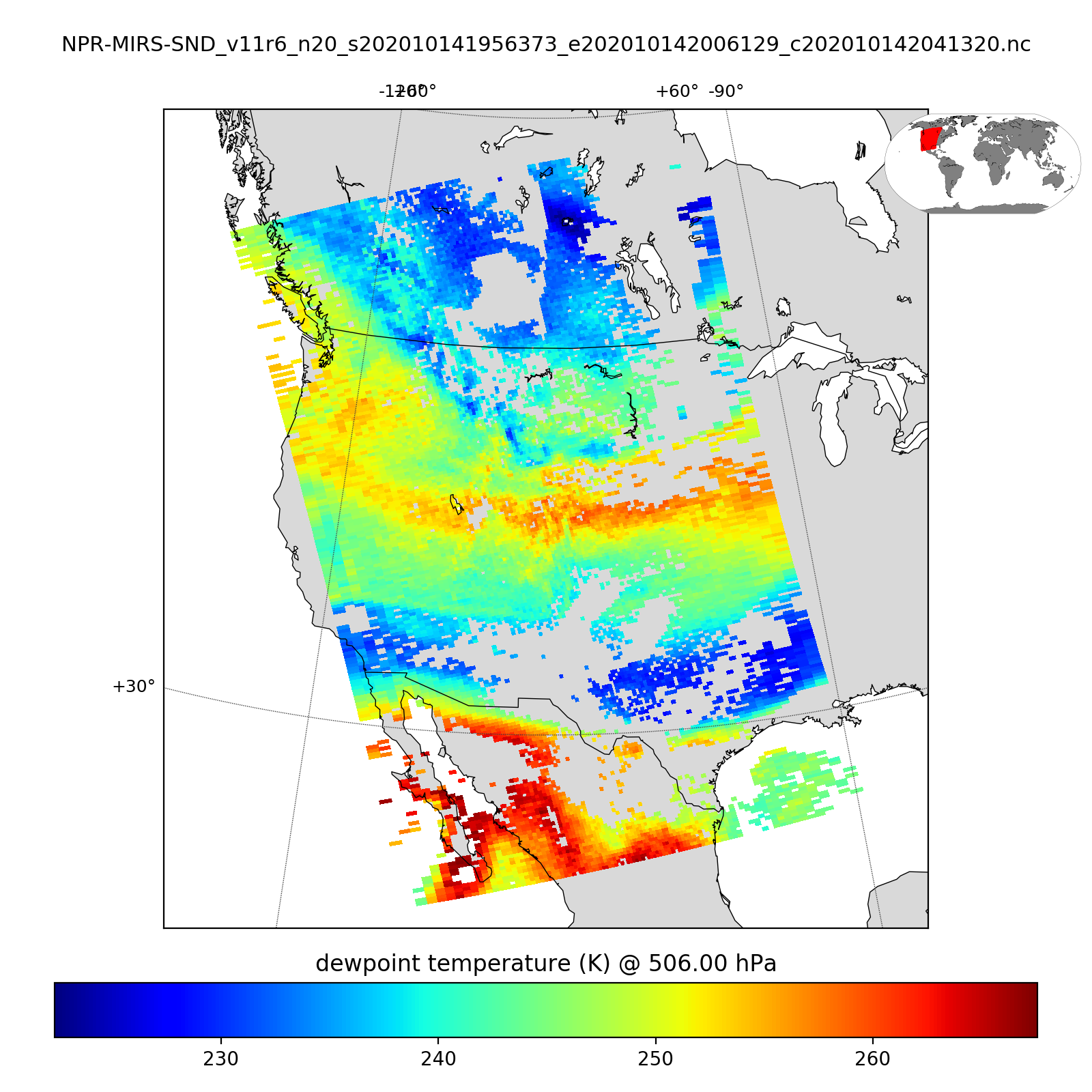
New CSPP MiRS Software Released in Support of Direct Broadcast Users: A new version of the NOAA/NESDIS/STAR Microwave integrated Retrieval System (MiRS) was released as part of the Community Satellite Processing Package (CSPP), in support of NOAA-20 and Suomi-NPP Advanced Technology Microwave Sounder (ATMS), and NOAA-18,-19, Metop-A,-B,-C Advanced Microwave Sounding Unit-A (AMSU-A) and Microwave Humidity Sounder (MHS) direct broadcast sensor data. The code base is updated to Version 11.6, with support added for the Metop-C platform. MiRS provides a wide variety of validated retrieval products, including temperature and moisture profiles, cloud and surface properties. This CSPP release allows global users with local receiving capabilities to produce and use products in near-real-time in support of environmental decision makers. (K. Strabala, CIMSS, 608-263-8752, J. Davies, CIMSS)
 (Click image to enlarge)
Figure: Community Satellite Processing Package (CSPP) Microwave integrated Retrieval System (MiRS) NOAA-20 ATMS retrieval image created from a direct broadcast overpass acquired on 14 October 2020. The image shows 500hPa dewpoints.
AWARDS AND RECOGNITION:
PUBLICATIONS:
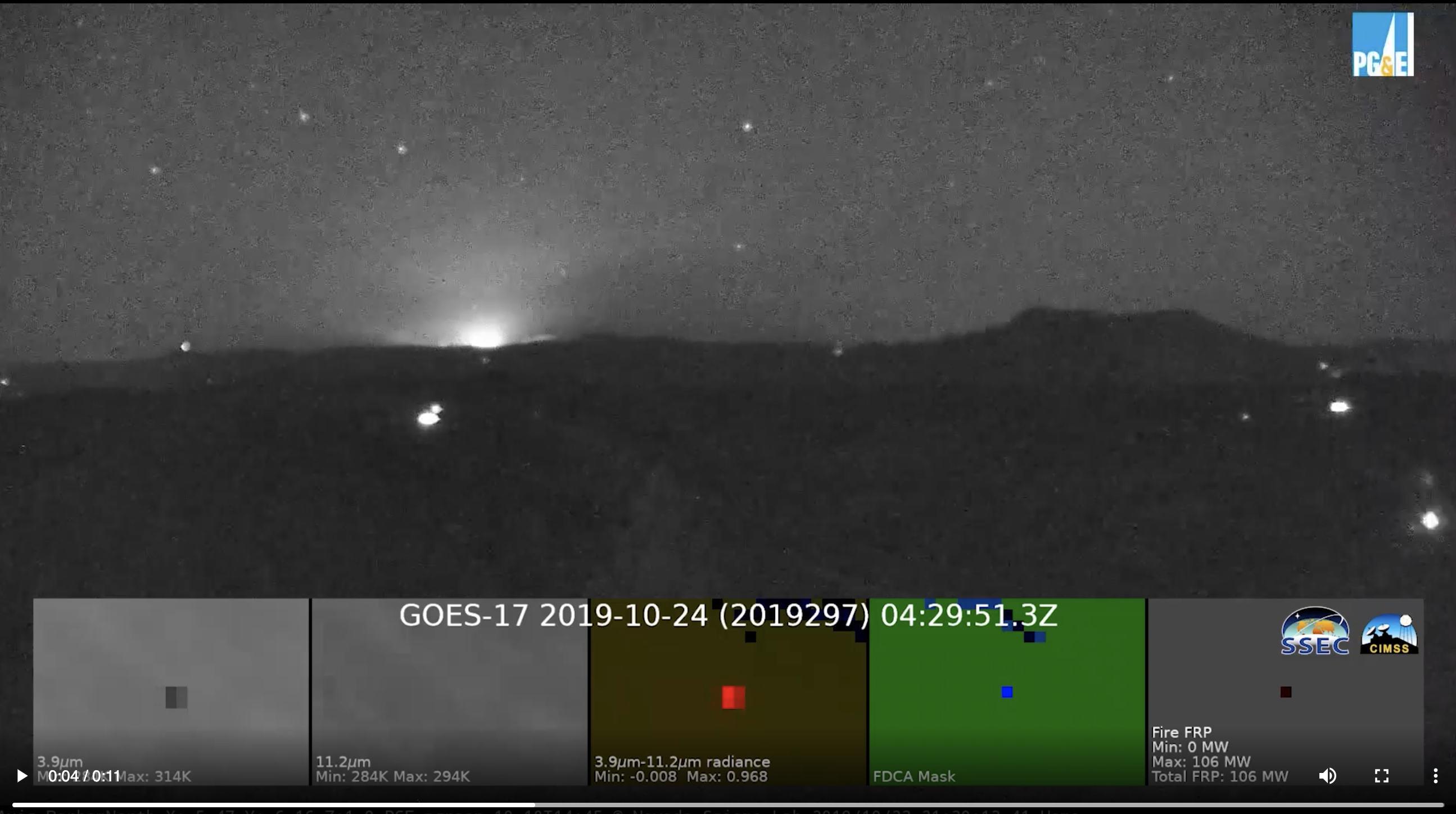
Paper published on operational utility of ABI fire products: A case study of the Kincade Fire that corroborates that Geostationary Operational Environmental Satellite (GOES)-17 Advanced Baseline Imager (ABI) fire detection capabilities can be utilized in an operational context has been published. Retrospective analysis of ABI data was compared to observations from the ALERTWildfire fire surveillance video system to show that the Kincade Fire's heat signature became visually evident in GOES-17 band 7 shortwave infrared imagery 52s after the ground-based cameras detected a near-infrared heat source. NOAA's operational ABI fire algorithm, the Fire Detection and Characterization Algorithm (FDCA), detected the fire 5 minutes after the apparent ignition. The paper demonstrates that the lack of FDCA processing of mesoscale (1 minute) ABI scans added two minutes to the delay compared to mesoscale data processed at the Space Science Engineering Center (SSEC) using the same algorithm. This case also highlights the need for algorithm development to improve early fire detection. This paper represents the first peer-reviewed examination of a very well-defined fire initiation time and GOES ABI detection of the fire. Full citation: Lindley, T. T., A. B. Zwink, C. M. Gravelle, C. C. Schmidt, C. K. Palmer, S. T. Rowe, R. Heffernan, N. Driscoll, and G. M. Kent, 2020: Ground-based corroboration of GOES-17 fire detection capabilities during ignition of the Kincade Fire. Journal of Operational Meteorology, 8 (8), 105-110, doi: https://doi.org/10.15191/nwajom.2020.0808. (C. Schmidt, CIMSS, 608-262-7973)
 (Click image to enlarge and animate)
WORKSHOPS, CONFERENCES, AND MEETINGS:
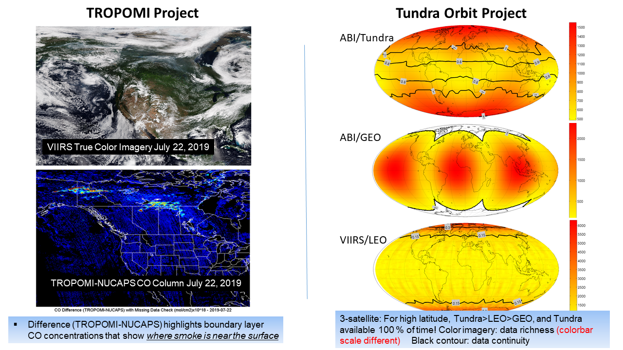
Two presentations at the Technology Maturation Program Annual Review Meeting: Scientists from the Cooperative Institute for Meteorological Satellite Studies (CIMSS) and the Advanced Satellite Products Branch (ASPB) gave two presentations to the Science Support to the Office of. Projects, Planning, and Analysis (OPPA) Technology Maturation Program (TMP) Annual Review Meeting held (virtually) on October 15, 2020. The titles were "Exploit TropOMI Sensor" and "Demonstrating the Potential Benefits of a Tundra Orbit". The presentations are available upon request. (T. Schmit, E/RA2, 608-263-0291)
 (Click image to enlarge)
Figure: Sample results from both projects, using multiple sensors to estimate low-level smoke and a 3-satellite tundra configuration.
 (Click image to enlarge)
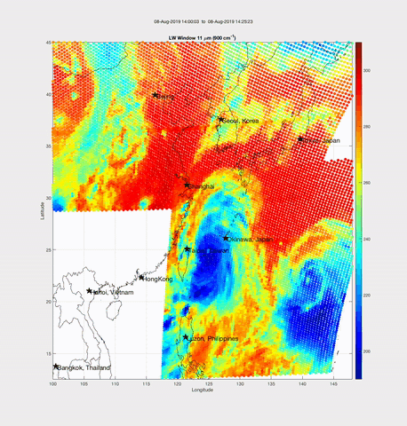
Figure: Example of the FY4A GIIRS satellite brightness temperature in the LW window with 30 minute refresh time from 08 August 2019.
TRAINING AND EDUCATION:
VISIT Training on Fog/Low Stratus IFR Probability Products: Scott Lindstrom from the Cooperative Institute for Meteorological Satellite Studies (CIMSS) gave Virtual Institute for Satellite Integration Training (VISIT) instruction on Instrument Flight Rule (IFR) Probability fields. GOES-16 versions of these fields have recently begun flowing into National Weather Service Forecast Offices over the Satellite Broadcast Network (SBN). This live training event was to a forecaster in the Anchorage, AK forecast office. GOES-17 IFR Probability fields over Alaska are being created by CIMSS for future distribution via LDM to Alaska Region. (Scott Lindstrom, CIMSS, 608 263 4425)
MEDIA AND OUTREACH:
SSEC and CIMSS Scientists in the News: Scientists at the University of Wisconsin-Madison (UW) Space Science and Engineering Center (SSEC) and the Cooperative Institute for Meteorological Satellite Studies (CIMSS) provide expert interviews, imagery and case studies to promote science. This week: 1) NOAA NCEI scientist Jim Kossin, who is based at CIMSS, was interviewed for a story on trends in hurricane behavior. Read the SSEC News story here: https://www.ssec.wisc.edu/news/articles/13243/. 2) CIMSS Satellite Blog contributors Scott Lindstrom and Scott Bachmeier published case studies on "GOES-17 IFR Probability fields are now being created for Alaska" (Oct. 15), "Cameron Peak Fire becomes the largest on record for Colorado" (Oct. 14), "Upper-tropospheric stability around wildfires" (Oct. 14), "NUCAPS Lapse Rates ahead of a line of convection in lower Michigan" (Oct. 12), and "Leeside cold frontal gravity wave across the central and southern Plains" (Oct. 11). Read more: https://cimss.ssec.wisc.edu/satellite-blog/archives/38484. (J. Phillips, SSEC, 608-262-8164, J. Kossin, NOAA NCEI/CIMSS, 608-265-5356, S. Lindstrom, CIMSS, S. Bachmeier, CIMSS)
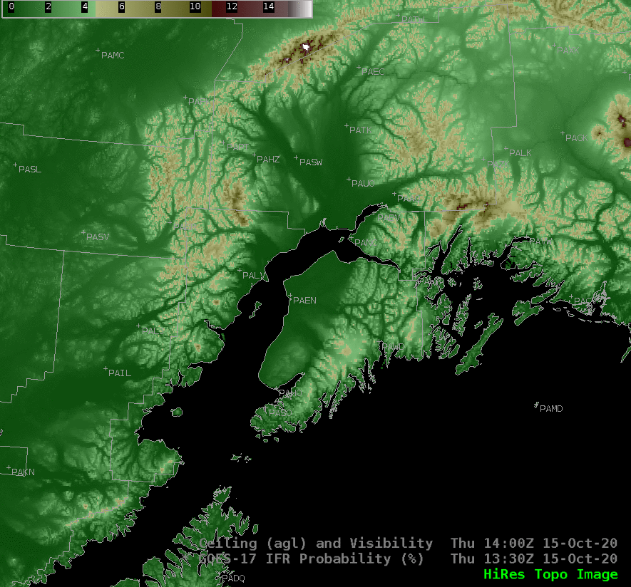 (Click image to enlarge)
Figure: GOES-17 IFR (Instrument Flight Rule) Probability fields over Anchorage, AK and surrounding area on Oct. 15, 2020 preceded by a view of topographic features. NOAA/NESDIS may begin processing the fields in 2021. See: https://go.wisc.edu/54ra7i. Credit: CIMSS.
OTHER:
| Archived Weeklies Page | Submit a report item |