[ Archive ]
| CIMSS-NOAA Weekly Report [ Archive ] |
CIMSS AND ASPB WEEKLY HIGHLIGHTS FOR THE WEEK ENDING NOVEMBER 20, 2020
PRODUCTS AND APPLICATIONS:
CSPP Direct Broadcast Retrieval Software Release: A new version of the NOAA/NESDIS/STAR Hyper-Spectral Enterprise Algorithm Package (HEAP) retrieval software was released as part of the Community Satellite Processing Package (CSPP) in support of the global direct broadcast community. The software supports retrievals of atmospheric profiles of temperature, moisture, trace gases and cloud-cleared radiances from Suomi-NPP/NOAA-20 CrIS+ATMS Sensor Data Records (SDRs) and IASI+AMSUA/MHS Level1-b files for Metop-A, B, and C. This update includes optimized recompiled binaries and SO2 retrieval support for Suomi-NPP and NOAA-20 satellites. (J. Davies, SSEC, 608-265-8007, K. Strabala, CIMSS)
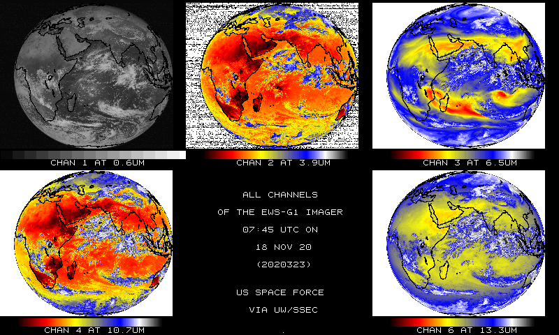
SSEC Receiving EWS-G1 Data: The University of Wisconsin-Madison Space Science and Engineering Center (SSEC) Data Services is now acquiring the GVAR (GOES Variable) signal from the U.S Space Force EWS-G1 (Electro-optical Infrared Weather System Geostationary) satellite. Near realtime imagery are being posted on the SSEC geo-browser page (https://www.ssec.wisc.edu/data/geo/#/animation?satellite=ews-g1) of each of the five spectral bands. The imager provides full disk imagery, centered on the equator and approximately 61 East longitude, every half an hour. A CIMSS Satellite Blog on this topic is available at https://cimss.ssec.wisc.edu/satellite-blog/archives/38928. (SSEC Data Services and T. Schmit, E/RA2)
 (Click image to enlarge)
Figure: The five spectral bands of the EWS-G1 Imager, from November 18, 2020.
AWARDS AND RECOGNITION:
PUBLICATIONS:
Geostationary Sounder Value Assessment Report: The Geostationary and Extended Orbits (GEO-XO) Hyperspectral InfraRed Sounder Value Assessment Report was prepared and submitted to the program office. The GEO-XO Hyperspectral Value Assessment Team consisted of Subject Matter Experts (SMEs) and comprised broad-based stakeholder representatives, was formed from both NOAA and NASA participants, as well as others such as from the cooperative institutes. The report is over 160 pages, covering the science, the need, potential applications and economic impacts. Copies available upon request from GEO XO. (T. Schmit, E/RA/2)
.png) (Click image to enlarge)
(Click image to enlarge)
Figure: Figure 3-1 from the value assessment report, showing the incredible increase in spectral resolution going from a broad-band imager to a hyperspectral infrared sounder.
WORKSHOPS, CONFERENCES, AND MEETINGS:
Participation in WMO International Verification Methods Workshop: Jason Otkin and Ralph Petersen, both from the Cooperative Institute for Meteorological Satellite Studies (CIMSS), participated virtually in the 7th World Meteorological Organization (WMO) International Verification Methods Workshop. Oktin's presentation discussed the benefits of using object-based verification methods and satellite observations to assess the accuracy of high-resolution model forecasts. Petersen's talk focused on the availability, quality and use of meteorological observations from commercial aircraft as a means of validating other profile observations and verifying Numerical Weather Prediction (NWP) model forecasts of vertical tropospheric structures throughout the days. (J. Otkin, CIMSS, 608-265-2476; R. Petersen, CIMSS, 262-763-2583).
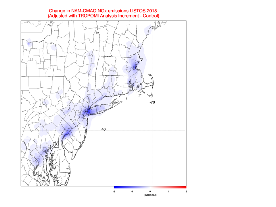
EPA Satellite Webinar: Brad Pierce served as panel member on a U.S Environmental Protection Agency (EPA) Satellite Webinar entitled "Moving from Research to regular utilization of satellite data: NO2 and O3" on November 19, 2020. The goal of the workshop was to assess recent advancements in remote sensing and inform EPA's operational satellite assimilation framework. Brad served as an expert on three dimensional variational (3DVAR) composition assimilation and presented results from both global and regional assimilation experiments (R. Pierce, 608-890-1892, rbpierce@wisc.edu)
 (Click image to enlarge)
Figure: Assimilation of TropOMI NO2 results in significant (~14%) reductions in NWS NAM-CMAQ NOx emissions over NYC in July-August 2018.
TRAINING AND EDUCATION:
VISIT Training on NUCAPS Profiles: Scott Lindstrom from the Cooperative Institute for Meteorological Satellite Studies (CIMSS) gave a Virtual Institute for Satellite Integration Training (VISIT) session on NUCAPS (NOAA-Unique Combined Atmospheric Processing System) Profiles that are available in AWIPS at National Weather Service forecast offices. The training includes information on how individual profiles are created and displayed, how they can be modified in AWIPS, and on gridded thermodynamic fields that are derived from the NUCAPS profiles. This live training was given to the a new meteorologist at Eastern Region Headquarters. (Scott Lindstrom, CIMSS, 608 263 4425)
MEDIA AND OUTREACH:
SSEC and CIMSS Scientists in the News: Scientists at the University of Wisconsin-Madison (UW) Space Science and Engineering Center (SSEC) and the Cooperative Institute for Meteorological Satellite Studies (CIMSS) provide expert interviews, imagery and case studies to promote science. 1) SSEC News published a special edition of Through the Atmosphere. The Climate Issue highlights research at SSEC and CIMSS that is increasing understanding of our climate and offering paths to solutions. Read more: https://www.ssec.wisc.edu/news/articles/13301. 2) NCEI scientist Jim Kossin and CIMSS scientist Shane Hubbard talked with Spectrum News1 for a story on trends in hurricane behavior and related costs of natural disasters. The interview aired in the morning on Thursday, November 19, 2020. Read more: https://go.wisc.edu/2g9x0b. 3) CIMSS Satellite Blog contributors Scott Bachmeier, Tim Schmit, and Scott Lindstrom published case studies on "Offshore transport of glacial silt over the Gulf of Alaska" (Nov. 18), "Imagery from the EWS-G1 — U.S. Space Force" (Nov. 18), "SpaceX launch of the Crew Dragon mission" (Nov. 15), "Hurricane Iota in the Caribbean Sea" (Nov. 15), and "Typhoon Vamco approaches Vietnam" (Nov. 13). Read more: https://cimss.ssec.wisc.edu/satellite-blog/. (J. Phillips, SSEC, 608-262-8164, E. Verbeten, SSEC, L. Avila, CIMSS, Callyn Bloch, CIMSS, J. Kossin, NOAA/NCEI/CIMSS, 608-265-5356, S. Hubbard, CIMSS, S. Bachmeier, CIMSS, T. Schmit, E/RA2, 608-263-0291, S. Lindstrom, CIMSS)
 (Click image to enlarge)
Figure: GOES-17 (GOES-West) images showed the offshore transport of glacial silt across the Gulf of Alaska on Nov. 17-18, 2020. See the Satellite Blog case study: https://go.wisc.edu/1u92ue. Credit: CIMSS, Geo2Grid.
 (Click image to enlarge)
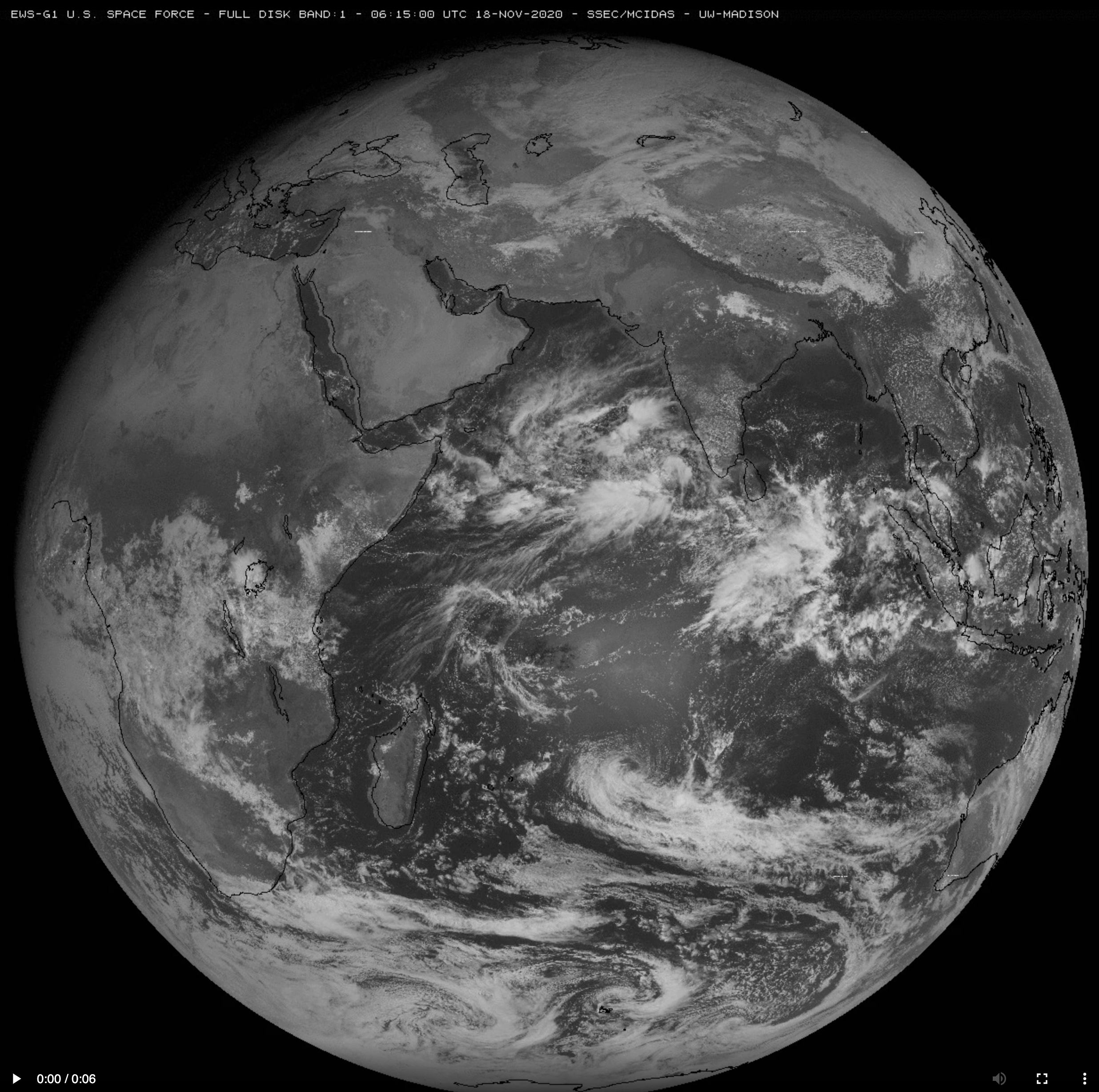
Figure: Full-disk images from the EWS-G1 (Electro-optical Infrared Weather System Geostationary), a U.S. Space Force mission, are now available from the SSEC Geostationary Satellite Image Browser. An animation of the imager's five spectral bands is available at https://stratus.ssec.wisc.edu/aspb/weeklies/archive/20/11-20/EWS_G1_FD_5bnds.mp4. (https://go.wisc.edu/09hqd9) Credit: SSEC, CIMSS.
OTHER:
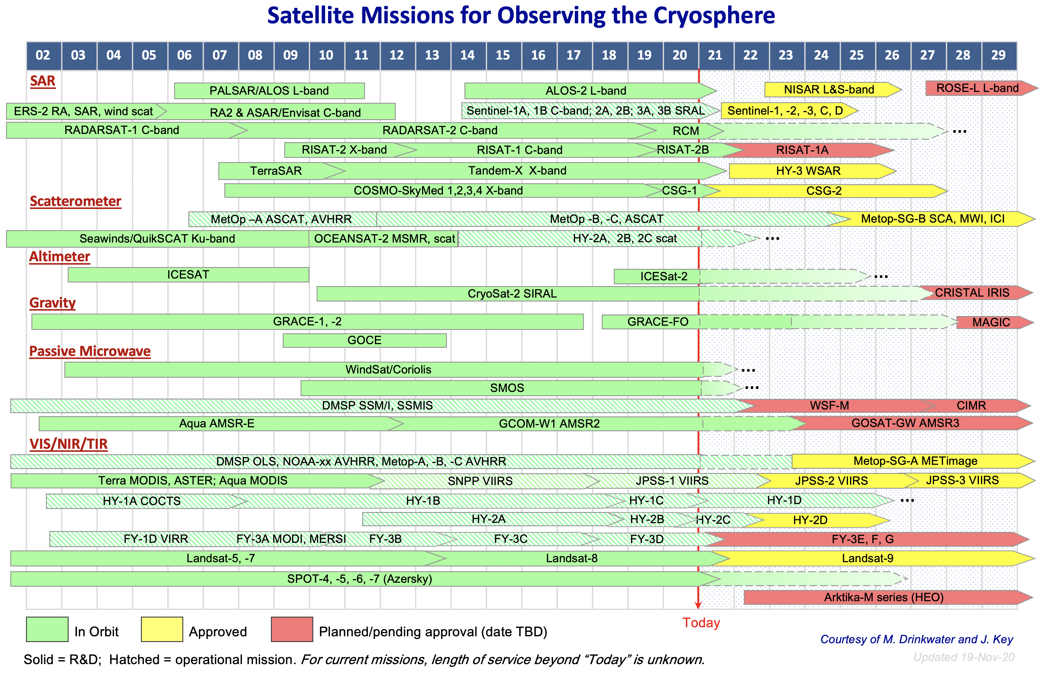
A Look at Satellite Missions for Observing the Cryosphere: Snow cover, floating ice (sea, lake, and river ice), and land ice (glaciers, ice sheets) are observed and characterized by a variety of satellite instruments: synthetic aperture radar (SAR), scatterometers, radar and laser altimeters, gravity measurements, passive microwave radiometers, and optical imagers. Each provides information on different properties of snow and ice, and all are necessary for a robust cryosphere observing system. A graphical illustration of the primary satellite missions for observing the cryosphere since the early 2000’s is shown below. It includes current satellites such as JPSS, and future missions from the U.S., Canada, Europe, China, India, and Russia. It is a simplified depiction of a complex system, but useful for providing a quick view of the space-based cryosphere observing system's evolution. The full-size figure is available at https://bit.ly/3kOyumr. (Note: It is a work in progress and may have minor errors.) (J. Key, E/RA2, 608-263-2605, jeff.key@noaa.gov)
 (Click image to enlarge)
| Archived Weeklies Page | Submit a report item |