[ Archive ]
| CIMSS-NOAA Weekly Report [ Archive ] |
CIMSS AND ASPB WEEKLY HIGHLIGHTS FOR THE WEEK ENDING DECEMBER 11, 2020
PRODUCTS AND APPLICATIONS:
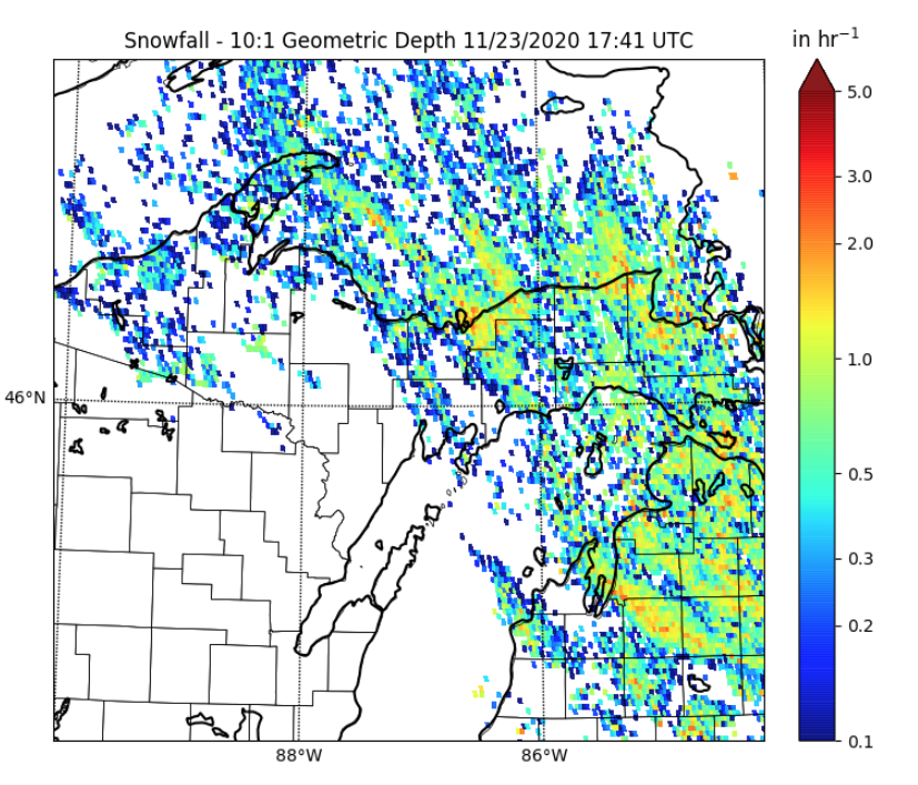
Experimental GOES Lake-Effect Snow Product Released: An experimental GOES lake-effect snow quantitative precipitation estimation (QPE) product was recently released for operational testing by the University of Wisconsin-Madison's Cooperative Institute for Meteorological Satellite Studies (CIMSS). The GOES QPE product uses a training dataset of fused NEXRAD QPE and GOES Algorithm Working Group cloud products to augment NEXRAD observations in Great Lakes regions that suffer from degraded NEXRAD coverage. This project also incorporates ground-based observations from a specialized snowfall measurement instrumentation suite at the Marquette, Michigan National Weather Service Weather Forecast Office to improve both NEXRAD and GOES QPE for lake-effect snow events. This product has been jointly developed by Claire Pettersen (CIMSS), Mark Kulie (NOAA/NESDIS/STAR/ASPB), Marian Mateling (CIMSS), Tim Wagner (CIMSS), Steve Wangzong (CIMSS), Andi Walther (CIMSS), and Andy Heidinger (NOAA/NESDIS). The product is currently produced for the Lake Superior and northern Lake Michigan region and can be viewed at the following website: https://www.ssec.wisc.edu/les-goes16/image-viewer. (M. Kulie, E/RA2, 608-263-6583, mark.kulie@noaa.gov)
 (Click image to enlarge)
Figure: GOES lake-effect snow QPE product example for a recent lake-effect snow event over the northern Great Lakes region on 23 November 2020.
AWARDS AND RECOGNITION:
PUBLICATIONS:
WORKSHOPS, CONFERENCES, AND MEETINGS:
Participation in the NIDIS Flash Drought Workshop: Jason Otkin, Cooperative Institute for Meteorological Satellite Studies (CIMSS), participated in a workshop organized by the National Integrated Drought Information System (NIDIS) that brought together international experts on flash drought and various stakeholders that could benefit from improved monitoring and forecasting of these events. This 3-day workshop was held virtually from 01-03 December 2020. Flash droughts have garnered increasing attention in the media and scientific community due to the occurrence of many high-impact events in the U.S. during the past decade. These climate phenomena are characterized by a period of rapid drought intensification over sub-seasonal time scales that requires adjustments to existing monitoring and prediction methods. Dr. Otkin was a facilitator for two breakout sessions and gave a presentation discussing various tools that can be used to monitor flash drought conditions. He was also a member of the scientific steering committee. (J. Otkin, CIMSS, 608-265-2476)
TRAINING AND EDUCATION:
Remote Training to the Department of Meteorology and Hydrology in Myanmar: Scott Lindstrom from the Cooperative Institute for Meteorological Satellite Studies (CIMSS) gave ten daily 3-hour remotely-presented training lectures during the weeks of 30 November - 4 December and 7 December - 11 December to about 30 members of the Myanmar Department of Hydrology and Meteorology. The topic was Tropical Forecasting and followed remote training on Tropical Synoptic meteorology given in early October this year, and in-person training on Tropical Synoptic Meteorology in early March 2020. The training was sponsored by the World Meteorological Organization (WMO) and funded through COMET. (S. Lindstrom, CIMSS, 608 263 4425)
MEDIA AND OUTREACH:
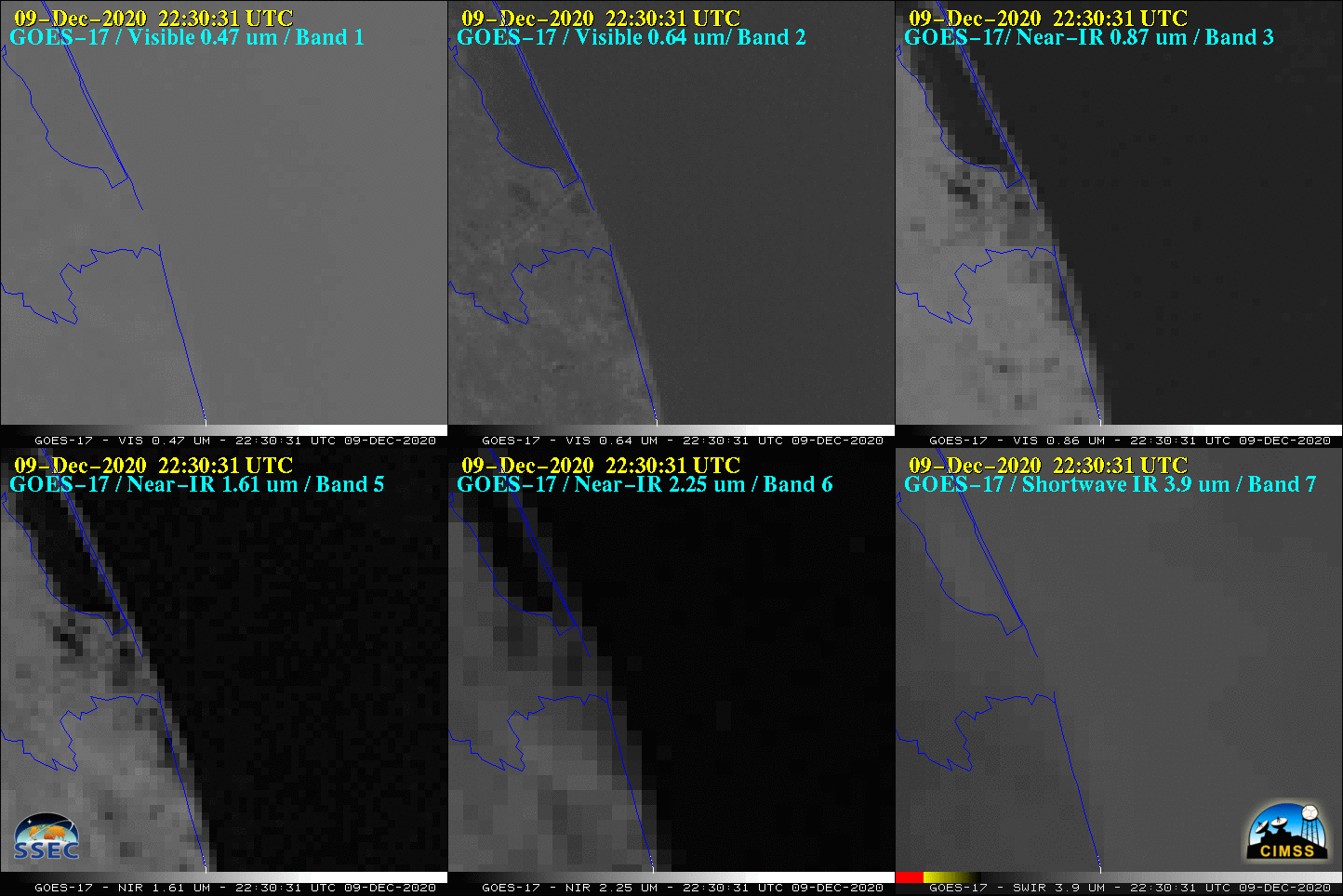
SSEC and CIMSS Scientists in the News: Scientists at the University of Wisconsin-Madison (UW) Space Science and Engineering Center (SSEC) and the Cooperative Institute for Meteorological Satellite Studies (CIMSS) provide expert interviews, imagery and case studies to promote science. 1) NOAA NCEI scientist Jim Kossin collaborated with John Leslie (NOAA Office of Communications) and John Bateman (NOAA Public Affairs) on a Q&A about the 2020 hurricane season that was published by NESDIS News. Read more: https://go.wisc.edu/r9b4tq. 2) CIMSS Satellite Blog contributor Scott Bachmeier published case studies on "Satellite signatures of the Space-X Starship SN8 flight" (Dec. 9), "Persistent snow cover in Oklahoma and Kansas" (Dec. 8-9), "Power Plant plume in West Virginia" (Dec. 7), "Signatures of the Alaska Range on Water Vapor imagery" (Dec. 5), and "Wildfires in Southern California" (Dec. 3). Read more: https://cimss.ssec.wisc.edu/satellite-blog/. (J. Phillips, SSEC, 608-262-8164, J. Kossin, NOAA/NCEI/CIMSS, 608-265-5356, S. Bachmeier, CIMSS)
 (Click image to enlarge)
Figure: GOES-17 visible, near-infrared, and shortwave infrared imagery showed visible and hot thermal signatures of the explosion of Space-X Starship SN8 upon landing on Dec. 9, 2020. More information at the CIMSS Satellite Blog post: https://cimss.ssec.wisc.edu/satellite-blog/archives/39167. Credit: CIMSS
OTHER:
| Archived Weeklies Page | Submit a report item |