[ Archive ]
| CIMSS-NOAA Weekly Report [ Archive ] |
CIMSS AND ASPB WEEKLY HIGHLIGHTS FOR THE WEEK ENDING JANUARY 15, 2021
PRODUCTS AND APPLICATIONS:
RealEarth Server Dedicated to CIMSS Cloud Products: A new dedicated RealEarth server has been set up to display operational GOES and VIIRS cloud product imagery (https://clouds.ssec.wisc.edu). Products include a resent archive of cloud mask, height, temperature, and others. (J. Hoffman, CIMSS 608-890-1690)
 (Click image to enlarge)
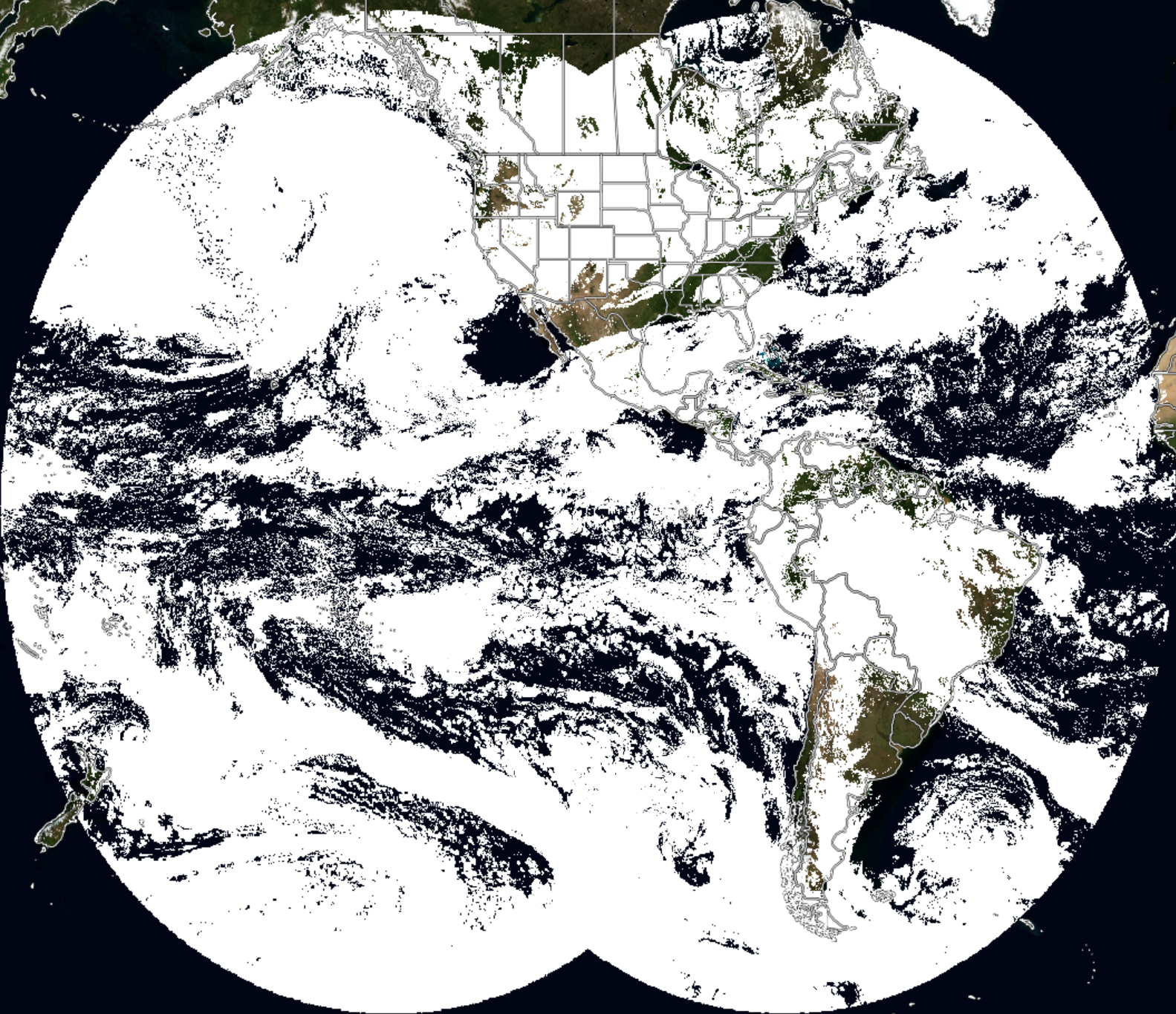
Figure: A recent composite of GOES-16 and GOES-17 clear sky masks as displayed in RealEarth.
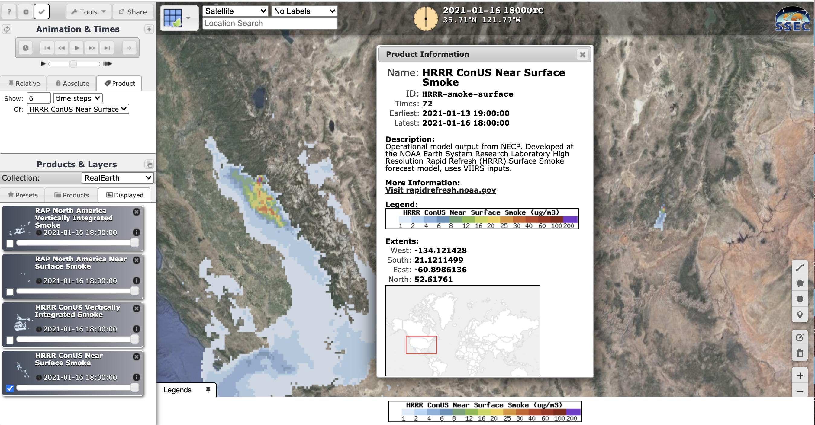
Operational HRRR and RAP Smoke Forecasts now in SSEC RealEarth: Researchers at the Space Science and Engineering Center/ Cooperative Institute for Meteorological Satellite Studies (SSEC/CIMSS) are now displaying operational High-Resolution Rapid Refresh (HRRR) and Rapid Refresh (RAP) smoke forecasts in the SSEC RealEarth visualization platform. The 3km resolution HRRR surface and vertically integrated smoke forecast estimates for CONUS and Alaska have been very popular products in RealEarth for years and were previously made available from the experimental model developed at the NOAA Earth System Research Laboratory (ESRL). Now the source is the operational data from NCEP. While the HRRR grids were familiar, integrating the 13.5km full North American domain for RAP smoke in RealEarth posed challenges due to its rarely used (at least in the GIS community) "rotated sphere" projection. Working with Kevin Sampson of UCAR and Eric James of ESRL, Sam Batzli of SSEC/CIMSS derived the projection definition in an interoperable geospatial format. One of the main advantages of having data in RealEarth stems from the extended GIS formats it makes available for all its products. Interoperability with GIS through OGC (Open Geospatial Consortium) formats has helped applications like ArcGIS and GeoCollobrate display and share smoke data via RealEarth with Emergency Operations Centers in response to western wildland fires. Solving the navigation-translation issue with the RAP full North American Domain makes it possible to integrate nearly all of the output variables with GIS for the first time. We have started with the smoke forecast variables, and as far as we know, RealEarth is the only platform making them available this way. (S. Batzli, SSEC/ERSC, W. Straka III, CIMSS)
 (Click image to enlarge)
Figure: Screen capture of operational HRRR smoke in RealEarth. Visit https://re.ssec.wisc.edu/s/A1HNOC to see it and other smoke products in action.
AWARDS AND RECOGNITION:
PUBLICATIONS:
Article Listed in Top 3 of Media Mentions in 2020: An article published in the Proceedings of the National Academy of Sciences of the United States of America (PNAS) by NOAA and CIMSS scientists has been listed at #3 of the climate papers most featured in the media in 2020, and #1 for the number of news articles (739). The analysis, performed each year by CarbonBrief, appears at https://bit.ly/3ihw4gL. (J. Kossin, NOAA/NCEI, 608-265-5356)
Article published in Governing: An article, based in part on an interview with Jim Kossin (NOAA/NCEI), appears on Governing.com, a website whose "audience consists of governors, mayors, county executives, city and county council members, state legislators, state and local agency executives and those holding key professional government positions." The article appears here: https://www.governing.com/community/Stronger-Hurricanes-Challenge-Housing-Recovery-Plans.html. (J. Kossin, NOAA/NCEI, 608-265-5356)
WORKSHOPS, CONFERENCES, AND MEETINGS:
WMO SG-Cryo Monitoring Group Meeting: As part of the major restructuring of the World Meteorological Organization (WMO), various Commissions, Standing Committees, Study Groups, and Expert Teams are being formed. One of the tasks of the new Study Group on Cryosphere (SG-Cryo) is to address the terms of reference for the WMO Global Cryosphere Watch (GCW), including its monitoring activities. The first meeting of SG-Cryo's Cryosphere Monitoring Task Team was held on 12 January 2021 to discuss gaps in cryosphere monitoring and uses of cryosphere data, both satellite and in situ. The Team must provide recommendations on how to better utilize cryosphere data and information for operational services and research applications. While not a member of SG-Cryo, Jeff Key (NOAA) was asked to participate as a representative and member of the Infrastructure Commission's Standing Committee on Earth Observing Systems and Monitoring Networks (SC-ON) and as a member of the GCW Steering Group. As such, he represented and promoted NOAA’s work on cryosphere monitoring from space with JPSS (VIIRS and AMSR2), GOES-R, and other platforms (e.g., Cryosat-2 and ICESat-2). (J. Key, E/RA2, 608-263-2605, jeff.key@noaa.gov)
University of Wisconsin-Madison CIMSS and SSEC and ASPB Participation at the 2021 AMS 101st Annual Conference: Representatives from the Cooperative Institute for Meteorological Satellite Studies (CIMSS), Space Science and Engineering Center (SSEC), and the NOAA Advanced Satellite Products Branch (ASPB) participated in the 101st Annual American Meteorological Society (AMS) meeting held virtually the week of January 10, 2021. There were over 45 oral presentations, 21 posters, and 15 chairs/conveners by CIMSS/SSEC staff as part of the 24th Conference on Satellite Meteorology, Oceanography, and Climatology, 17th Symposium on Operational Environmental Satellite Systems, 23rd Conference of Atmospheric Chemistry, 35th Conference on Hydrology, 20th Conference on Artificial Intelligence for Environmental Sciences, 25th Conference on Integrated Observing and Assimilation Systems, 11th Conference on Transition to Research to Operations, 11th Symposium on Lidar Atmospheric Applications, 37th Conference on Environmental Information Processing Technologies, 16th Symposium on Societal Applications: Policy, Research, and Practice, 30th Conference on Education, 4th Special Symposium on Tropical Meteorology and Cyclones, 7th Symposium on High Performance Computing, 37th Conference on Environmental Information Processing Technologies, 9th AMS Symposium on the JCSDA, 11th Symposium on Advances in Modeling and Analysis Using Python. Others participated in panels, networking sessions, student engagement, as session co-chairs, conference co-chairs and other roles. The SSEC booth in the (virtual) exhibit hall highlighted advances with McIDAS-V, SSEC RealEarth, Community Satellite Processing Package (CSPP), and the SSEC Data Services (SDS) and other hardware/software support. (W. Feltz, CIMSS/SSEC, 608-265-6283, wayne.feltz@ssec.wisc.edu; T. L’Ecuyer, CIMSS/SSEC, 608-890-2107, tlecuyer@wisc.edu, T. Schmit, E/RA2, 608-263-0291, tim.j.schmit@noaa.gov)
 (Click image to enlarge)
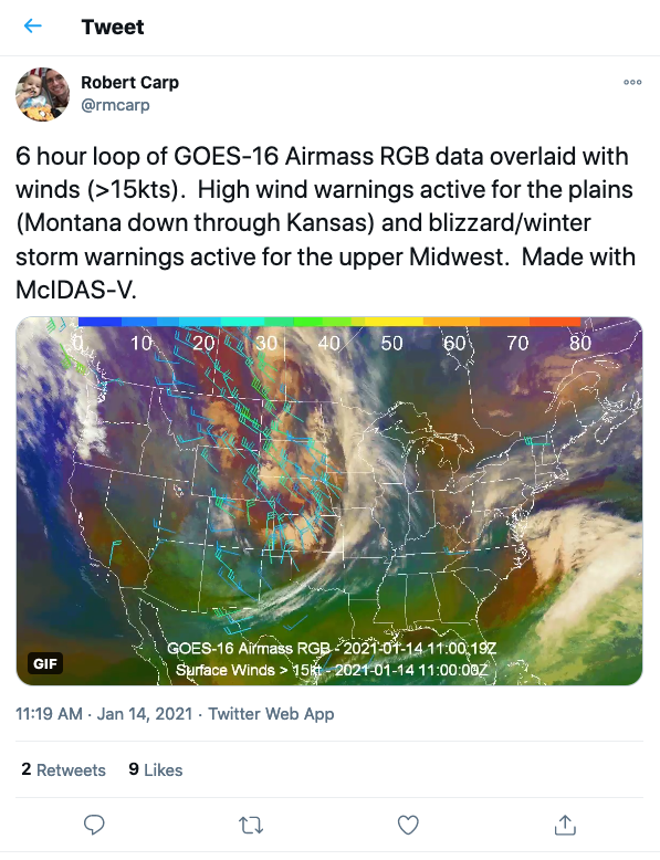
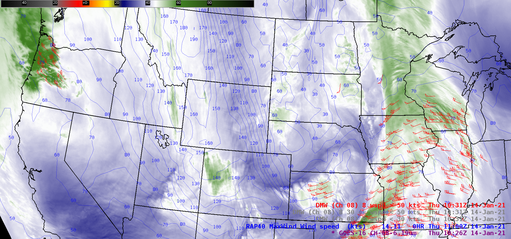
Figure: 6 hour loop of GOES-16 Airmass RGB data overlaid with winds (>15kts). High wind warnings active for the plains (Montana down through Kansas) and blizzard/winter storm warnings active for the upper Midwest. Made with McIDAS-V. (https://twitter.com/rmcarp/status/1349768104545542145)
TRAINING AND EDUCATION:
GOES Lake-Effect Snow Product Great Lakes NWS Training: University of Wisconsin-Madison (UW) Cooperative Institute for Meteorological Satellite Studies (CIMSS) scientists Claire Pettersen and Marian Mateling led a training session with Great Lakes Region National Weather Service (NWS) Science and Operations Officers (SOOs). Mark Kulie (NOAA/NESDIS) also participated in the session. All three scientists provide background information on an experimental GOES lake-effect snow quantitative precipitation estimation product that is currently being tested by the Marquette, MI NWS Weather Forecast Office (WFO). Case studies from the current winter were also shown and guidance was provided on how to apply the product most effectively for improved situational awareness for lake-effect snow events. In conjunction with Great Lakes NWS WFO's and SOOs, this product will undergo continued development and evaluation for the next two winter seasons. (M. Kulie, E/RA2, 608-263-6583, mark.kulie@noaa.gov)
MEDIA AND OUTREACH:
SSEC and CIMSS Scientists in the News: Scientists at the University of Wisconsin-Madison (UW) Space Science and Engineering Center (SSEC) and the Cooperative Institute for Meteorological Satellite Studies (CIMSS) provide expert interviews, imagery and case studies to promote science. 1) CIMSS Satellite Blog contributors Scott Bachmeier and Scott Lindstrom published case studies on "A leeside cold frontal gravity wave in the Plains, and a strong polar jet stream over the Rockies" (Jan. 14), "CIMSS GeoSphere website is now active" (Jan. 13), "Freezing fog in the Carolinas and Virginia" (Jan. 13), and "Winter storm affecting the southern Plains and Lower Mississippi Valley" (Jan. 10-11). Read more: https://cimss.ssec.wisc.edu/satellite-blog/. (J. Phillips, SSEC, 608-262-8164, S. Bachmeier, CIMSS, S. Lindstrom, CIMSS)
 (Click image to enlarge)
Figure: GOES-16 water vapor images captured the signature of a leeside, cold frontal gravity wave as it moved rapidly southward across the Plains on Jan. 14, 2021. Read more: https://go.wisc.edu/9067ic. Credit: CIMSS.
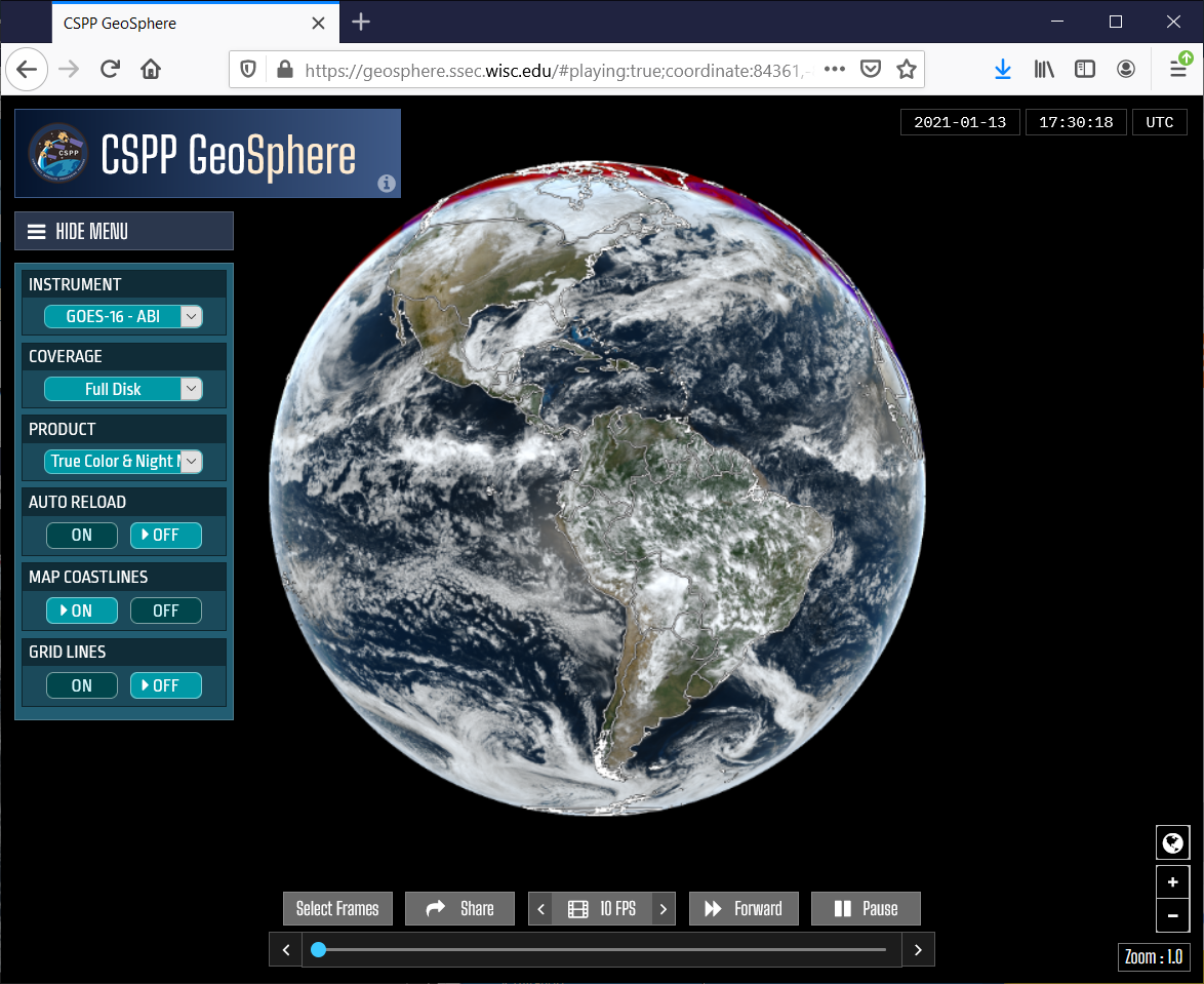 (Click image to enlarge)
Figure: Now available: The CIMSS CSPP-powered GeoSphere site, offering quick access to GOES-16 imagery via cloud-friendly, flexible (and configurable) software. Read more: https://go.wisc.edu/i9y307. Credit: CIMSS.
OTHER:
| Archived Weeklies Page | Submit a report item |