[ Archive ]
| CIMSS-NOAA Weekly Report [ Archive ] |
CIMSS AND ASPB WEEKLY HIGHLIGHTS FOR THE WEEK ENDING JANUARY 29, 2021
PRODUCTS AND APPLICATIONS:
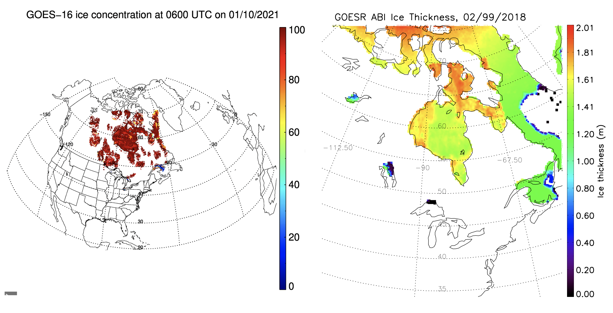
GOES-16/17 Ice Products Provisional Review: The GOES-16 and GOES-17 Advanced Baseline Imager (ABI) level-2 NOAT (NWS Operational Advisory Team) cryosphere products Provisional Peer/Stakeholder - Product Validation Review (PS-PVR) was held on 21 January 2021. The Provisional Maturity Review evaluated the status of the ABI Ice Concentration & Extent, Ice Age & Thickness, Ice Motion products. The GOES-R Cryosphere Team presented validation results for the ice products generated by the Ground System and by ASSISTT (Algorithm Scientific Software Integration and System Transition Team). The Ice Concentration & Extent, Ice Age & Thickness products were demonstrated to meet the accuracy and precision requirements. Ice Motion did not meet the requirements overall, possibly due to a small sample size in the validation study. Regardless, an algorithm improvement was proposed and demonstrated, and will be implemented in the coming months. The conclusion of the review board echoed the recommendations of the Cryosphere Team: that Ice Concentration & Extent and Ice Age & Thickness have reached Provisional Maturity for GOES-16 and for the GOES-17 "cool" period. This review declares that the Provisional data can be distributed from PDA (Product Distribution and Access) and CLASS to the broader user community. (J. Key, E/RA2, 608-263-2605, jeff.key@noaa.gov)
 (Click image to enlarge)
Figure: Ice concentration (left) and ice thickness (right) from ABI on two different dates.
AWARDS AND RECOGNITION:
PUBLICATIONS:
Manuscript on Tundra imaging capability published : A manuscript titled "Understanding the Imaging Capability of Tundra Orbits Compared to Other Orbits" was published in IEEE Transactions on Geoscience and Remote Sensing (https://ieeexplore.ieee.org/document/9336058). This work compares the imaging capability from imagers on Tundra orbits with geostationary and polar orbits, for single satellites as well as a constellation of multiple satellites. The main objective is to highlight the potentials of Tundra orbits for the imagery use in high latitudes and polar region. The co-authors are Zhenglong Li, Timothy Schmit, Jun Li, Mathew Gunshor, and Frederick Nagle. This work was supported by OPPA TMP and GEO-XO programs. (Zhenglong Li, 608-890-1982, zhenglong.li@ssec.wisc.edu).
WORKSHOPS, CONFERENCES, AND MEETINGS:
TRAINING AND EDUCATION:
MEDIA AND OUTREACH:
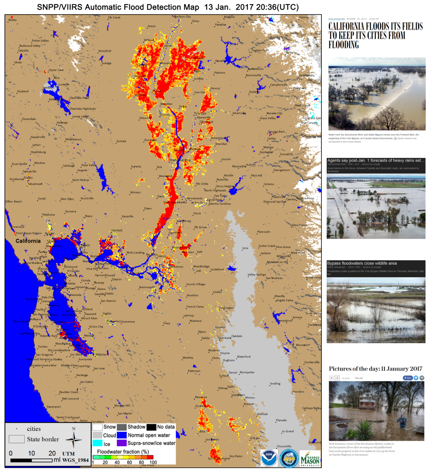
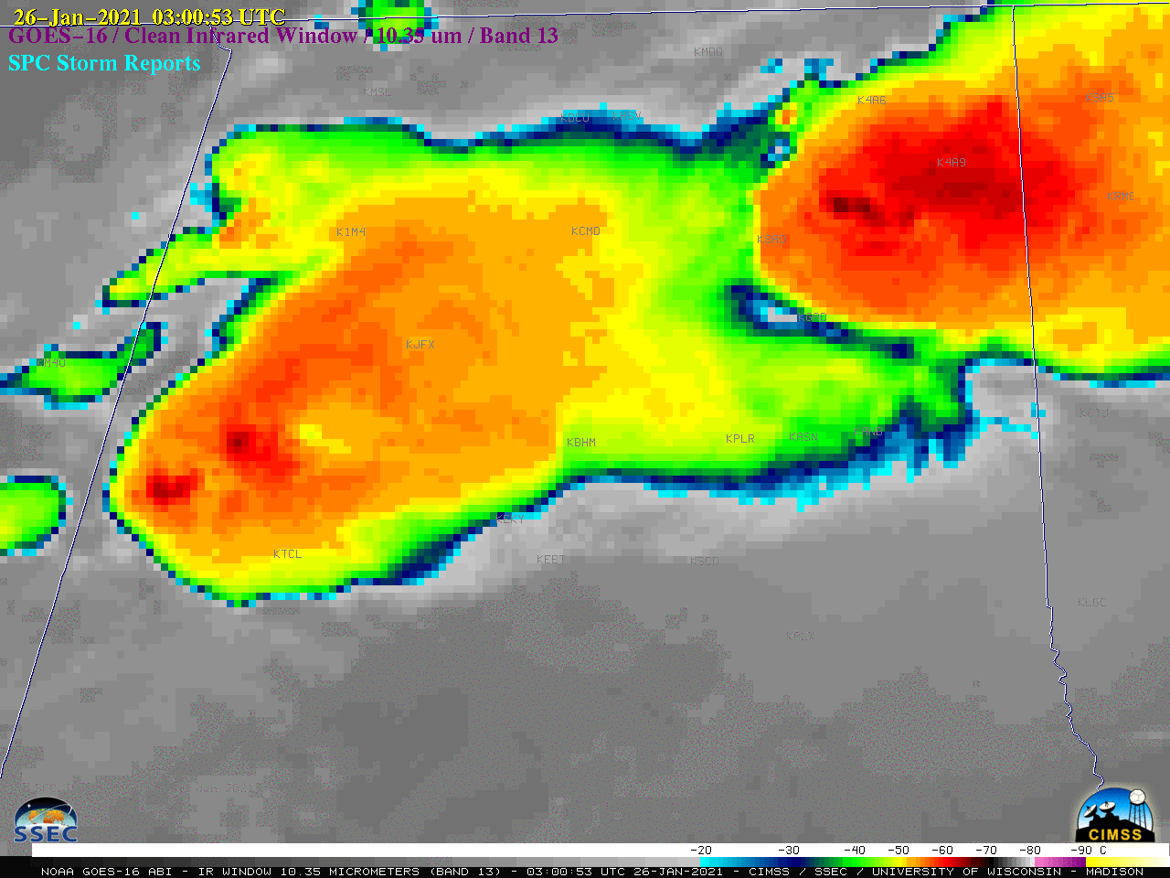
SSEC and CIMSS Scientists in the News: Scientists at the University of Wisconsin-Madison (UW) Space Science and Engineering Center (SSEC) and the Cooperative Institute for Meteorological Satellite Studies (CIMSS) provide expert interviews, imagery and case studies to promote science. This week: 1) To meet the growing challenge of monitoring floods, CIMSS researchers William Straka III and Jay Hoffman, along with Sanmei Li of George Mason University, are taking advantage of high-resolution satellite imagery to detect where they may occur and how people, cities and rural areas might be affected. More from SSEC News: https://www.ssec.wisc.edu/news/articles/13454/. 2) CIMSS Satellite Blog contributors Scott Lindstrom and Scott Bachmeier published case studies on "Snowfall across Virginia and North Carolina" (Jan 28), "NOAA/CIMSS ProbSevere with a tornado in Tallahassee, FL" (Jan. 27), "Tornado near Birmingham, Alabama" (Jan. 25), and "Heavy rainfall and snowfall in Southern California" (Jan. 23). Read more: https://cimss.ssec.wisc.edu/satellite-blog/. (J. Phillips, SSEC, 608-262-8164, C. Bloch, CIMSS, W. Straka III, CIMSS, J. Hoffman, CIMSS, S. Lindstrom, CIMSS, S. Bachmeier, CIMSS)
 (Click image to enlarge)
Figure: An example of VIIRS flood map (left) and pictures (right) of flooding in Northern California. Read more: https://www.ssec.wisc.edu/news/articles/13454/. Credit: CIMSS.
 (Click image to enlarge)
Figure: One-minute, GOES-16 (GOES-East) images of the large supercell moving northeastward across Alabama several hours after sunset on Jan. 25, 2021 that later produced an EF3 tornado north of Birmingham. Read more: https://cimss.ssec.wisc.edu/satellite-blog/archives/39747. Credit: CIMSS.
OTHER:
| Archived Weeklies Page | Submit a report item |