[ Archive ]
| CIMSS-NOAA Weekly Report [ Archive ] |
CIMSS AND ASPB WEEKLY HIGHLIGHTS FOR THE WEEK ENDING FEBRUARY 26, 2021
PRODUCTS AND APPLICATIONS:
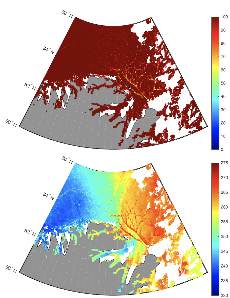
VIIRS 375-meter High-Resolution Warm Intrusion into the Arctic: The VIIRS Image Bands (I-bands) can be utilized to increase the resolution of the VIIRS ice products from 750 to 375-meter resolution. On 19 February 2021, a warm intrusion into the Arctic was observed from VIIRS Ice Surface Temperature (IST) Enterprise Algorithm just north of northeast Greenland. Utilizing the I-bands SVI01 (0.64 µm), SVI02 (0.865 µm), SVI03 (1.61 µm), and SVI05 (11.45 µm) we can derive Ice Concentration (SIC) and IST at twice the resolution of the M-band products. Due to the lack of an I-band at 12 µm for atmospheric moisture correction, the single band method published in 2018 is applied for IST determination. In the figure below, the 375-meter I-band SIC product shows leads (fractures) associated with lower ice concentrations, while the IST product illustrates the detail of the much warmer ice within leads. Noteworthy in this case is the warm instrusion into the Arctic and the large temperature gradient from warm (right) to cold (left), estimated to be about 20 K over 160 km. (R. Dworak, CIMSS, 608-265-8620; Y. Liu, E/RA2, 608-890-1893, yinghui.liu@noaa.gov; J. Key, E/RA2, 608-263-2605, jeff.key@noaa.gov)
 (Click image to enlarge)
Figure: 375-meter resolution (I-band) Sea Ice Concentration (top) and Ice Surface Temperature (bottom) over the Arctic Ocean north of Greenland on 19 February 2021.
AWARDS AND RECOGNITION:
PUBLICATIONS:
Paper Published on the Last AVHRR: A paper titled "The advanced very high resolution radiometer: Contributing to Earth observations for over 40 years" was published in the Bulletin of the American Meteorological Society (BAMS). The authors are S. Kalluri, C. Cao, A. Heidinger, A. Ignatov, J. Key, and T. Smith (https://doi.org/10.1175/BAMS-D-20-0088.1). The Advanced Very High Resolution Radiometers (AVHRR), which have been flying on NOAA’s polar-orbiting weather satellites since 1978, provide the longest global record of Earth observations from a visible–infrared imager. Over four decades of data have been vital for studying Earth and its change. The MetOp-C satellite that was launched in 2018 carries the last AVHRR. This article reviews the contributions of AVHRR in building a continuous global data record over the last 40 years on the occasion of its last launch. The paper is available at https://bit.ly/2NVH7AN. (J. Key, E/RA2, 608-263-2605, jeff.key@noaa.gov; A. Heidinger, 608-263-6757, andrew.heidinger@noaa.gov)
Manuscript on improving storm scale forecasts by assimilating combined GOES and radar data published: A manuscript titled "The Impact of Assimilating Satellite-derived Layered Precipitable Water, Cloud Water Path and Radar Data on Short-Range Thunderstorm Forecasts" has been published in Monthly Weather Review (https://journals.ametsoc.org/view/journals/mwre/aop/MWR-D-20-0040.1/MWR-D-20-0040.1.xml). It is found that assimilating additional GOES products improves short-range forecasts by providing more accurate initial conditions, especially for moisture and temperature variables. Co-authors are Sijie Pan (CIMMS/University of Oklahoma), Jidong Gao and Thomas A. Jones (NSSL/NOAA), Yunheng Wang (CIMMS/University of Oklahoma), Xuguang Wang (School of Meteorology/University of Okahoma), and Jun Li (CIMSS/University of Wisconsin-Madison). (Jun Li, CIMSS, 608-262-3755, Jun.Li@ssec.wisc.edu)
Manuscript on Model Bias Estimation for Data Assimilation Published: A manuscript entitled “Nonlinear conditional model bias estimation for data assimilation” was published in the February issue of the SIAM Journal of Applied Dynamical Systems (https://epubs.siam.org/doi/10.1137/19M1294848). Jason Otkin (CIMSS), Roland Potthast (German DWD), and Amos Lawless (University of Reading, UK) are the co-authors of this paper. (J. Otkin, CIMSS, 608-265-2476)
WORKSHOPS, CONFERENCES, AND MEETINGS:
EUMETSAT Workshop on the Use of Microwave Products for Polar Regions: EUMETSAT held a virtual scientific workshop titled "The Optimal Use of Operational Satellite Microwave Products for High Latitudes and Polar Area Models", 23-24 February 2021. The purpose of the workshop was to advance the utilization and impact of operational satellite microwave data in weather, climate, ocean and sea ice prediction and climate reanalyses in the high latitudes and polar areas. There were 18 presentations and four panel discussion. While most of the presentations and discussions focused on numerical weather prediction, there were also presentations specifically on sea ice product and upcoming microwave instruments. Yinghui Liu, Eric Bayler, and Jeff Key (STAR) participated in the workshop. More information is available at https://bit.ly/2NXxP7o. (J. Key, E/RA2, 608-263-2605, jeff.key@noaa.gov)
Participation in the 2021 DTC UFS Evaluation Metrics Workshop: Jason Otkin participated in a workshop that brought together model developers, forecasters, and verification experts to discuss which verification metrics and variables should be used to assess the accuracy of model forecasts and the impacts of proposed model changes. These discussions along with results from a set of pre-workshop surveys will be used to provide guidance on how to standardize evaluation procedures. Otkin was a facilitator for breakout sessions focusing on verification of short-range weather and medium-range weather applications and how to map verification metrics to different steps or gates in the research-to-operations process. He was also a member of the workshop organizing committee. (J. Otkin, CIMSS, 608-265-2476)
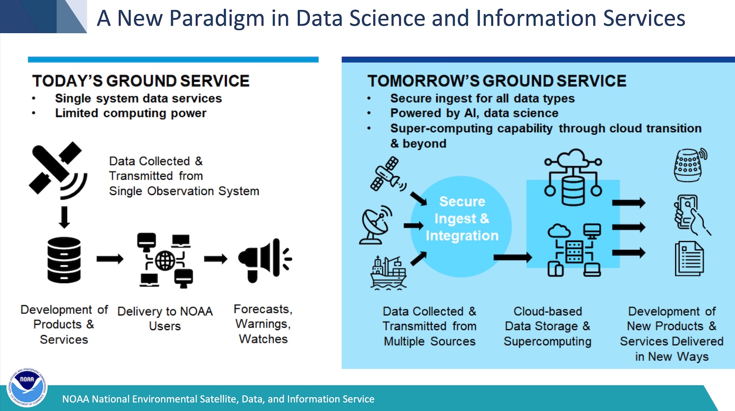
NESDIS Ground Enterprise Study Cycle 1 Kickoff Meeting: NESDIS Ground Enterprise Study (NGES) group held their Cycle 1 Kickoff Meeting on 24 February 2021. NGES is tasked to examine the capabilities and provide an optimal approach for designing an enterprise approach to the NESDIS ground architecture, primarily the capturing and processing of data, distribution of data to users, and archiving of data for future use. It will guide NESDIS’ transition away from unique ground systems for each satellite system and toward an enterprise ground capability that can incorporate an ever-evolving set of data sources. Cycle 0 established a baseline of the current ground system architecture. This includes science aspects, such as how NESDIS processes, stores, and archives data and products. Cycle 1 will to examine six scenarios that will test the bounds of the ground system architecture. Jeff Key and Laurie Rokke are are STAR representatives on NGES. (J. Key, E/RA2, 608-263-2605, jeff.key@noaa.gov)
 (Click image to enlarge)
Figure: Ground services, current and future.
TRAINING AND EDUCATION:
MEDIA AND OUTREACH:
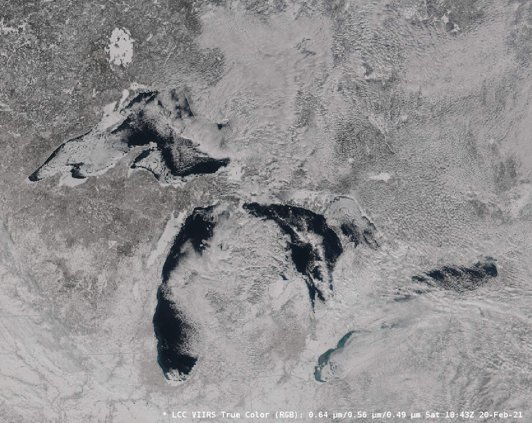
SSEC and CIMSS Scientists in the News: Scientists at the University of Wisconsin-Madison (UW) Space Science and Engineering Center (SSEC) and the Cooperative Institute for Meteorological Satellite Studies (CIMSS) provide expert interviews, imagery and case studies to promote science. This week: 1) CIMSS Satellite Blog contributors Scott Bachmeier and Scott Lindstrom published case studies on "Using 1-minute GOES-17 imagery to monitor tropical convection near American Samoa" (Feb. 21-23), "VIIRS Imagery shows ice cover on Great Lakes" (Feb. 20), "Ice motion on the Great Lakes" (Feb. 19-21), and "Eruption of Mount Etna" (Feb. 19). Read more: https://cimss.ssec.wisc.edu/satellite-blog/. (J. Phillips, SSEC, 608-262-8164, S. Bachmeier, CIMSS, S. Lindstrom, CIMSS)
 (Click image to enlarge)
Figure: 1-minute Mesoscale Domain Sector GOES-17 (GOES-West) infrared imagery showed thunderstorms associated with the South Pacific Convergence Zone on Feb. 21, 2021. Read more: https://cimss.ssec.wisc.edu/satellite-blog/archives/40019. Credit: CIMSS.
 (Click image to enlarge)
Figure: Suomi-NPP VIIRS, true-color images of the Great Lakes on Feb. 20, 2021. Read more: https://cimss.ssec.wisc.edu/satellite-blog/archives/40008. Credit: CIMSS.
OTHER:
| Archived Weeklies Page | Submit a report item |